Archive for April 2024
Slopes to flats
Tuesday

– photo by Mitch Waxman
As mentioned yesterday, a humble narrator was recently observed walking down a set of municipal steps here in Pittsburgh which are called – apparently – ‘German Square.’
I found a shot of them from 1933, on display at historicpittsburgh.org. Zillow indicates that this area is a named neighborhood which goes by German Square, and that several quite lovely homes are available here which could be all yours for about 200k. I guess that’s more or less confirmation of the naming convention.
It’s really quirky around here, nice houses but with somewhat forested and steeply graded properties surrounding them. Lovely view too, as you can see both the jail, and Duquesne University, from up here.
This was a pretty cool path to walk, I’d mention, although it ended up being fairly ‘physical,’ if you know what I mean.

– photo by Mitch Waxman
One was stretching the ligaments, toning the tendons, and macerating many muscles I didn’t even know I had. I mean, how often do you actually walk down 1,000 feet (about ten stories, that) of steps? It was great exercise, will do it again, but boy oh boy did I feel it the next day. Wow.
At the top of the shot is the Monongahela River, and that yellow bridge in the distance is the South Tenth Street bridge. On both sides of the stairs, heavy brush was observed growing amongst fairly developed deciduous trees. I’m sure that at night, this area is crawling with critters.

– photo by Mitch Waxman
On both sides of the stairs, there were wood framed homes, and I was careful to not violate anyone’s privacy while waving the camera about. In a few spots, the plank of concrete which served as a step sat loose in its metal framing and that was a fairly disconcerting experience. Law of averages, I guess.
After a few hundred feet worth of occasionally shifting stairs, a landing was coming up in front of me – in the form of an actual street – where I’d have to walk about a hundred feet eastwards in order to reacquire the steps.

– photo by Mitch Waxman
Fritz Street, I’m told, is where this spot is. Or, at least that’s what it’s called to the east of the German Square Steps, to the left (or west) it’s called Windom Street. Honestly, this city is invasion proof. An entire Battalion of enemy soldiers would just get lost into these hills and never be seen again.
The brick colored buildings at the right are the aforementioned city jail, the Liberty Bridge crosses the Monongahela River, and that’s Downtown Pittsburgh rising up to claim its place against the sky.

– photo by Mitch Waxman
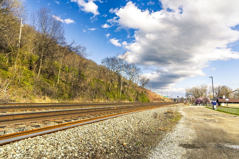
Just before reaching the ground, the German Square steps feed onto a small bridge which overflies railroad tracks. These tracks are Norfolk Southern’s domain. I’ve been working my way along these tracks for a bit.
Several posts have been offered from the P.J. McArdle roadway in recent weeks, which is just down the tracks west of here. This right of way seems a lot busier than the nearby CSX one, and in recent weeks I’ve been attempting to locate shooting POV locations along it. As you’ll see tomorrow – this is fairly good spot for such endeavors.

– photo by Mitch Waxman
I’ll end this post with the moment of explosive panic which occurred when I realized I had walked myself directly into a cage. Ahhh! Not again,
The good news about this cage, however, was that the chain link fencing which encapsulates the pedestrian path is the ‘old school’ kind with large inch and half diamonds woven into it. It’s sensible to vouchsafe the tracks and trains against somebody tossing something down on a moving train, but most of the more modern fencing you encounter in such places uses a design that incorporates tiny little diamond apertures of maybe a half to three quarters of an inch.
The latter are very difficult to get a photo through. There’s a reason that people cut ‘Bernie Holes’ into such fencing. Pfah!
Back tomorrow with more – at your Newtown Pentacle.
“follow” me on Twitter- @newtownpentacle
Buy a book!
“In the Shadows at Newtown Creek,” an 88 page softcover 8.5×11 magazine format photo book by Mitch Waxman, is now on sale at blurb.com for $30.
Twelve hundred steps program
Monday

– photo by Mitch Waxman
Famously, the City of Pittsburgh offers hundreds of flights of municipal steps for the usage of the citizenry, which aid pedestrians in navigating the challenging terrain of the place. Recent endeavor saw a humble narrator hire a taxi in order to get to the top of one of the more extreme examples of this sort of infrastructure (not the ones pictured above) and then proceed downward along the rises and runs. In my admittedly limited experience, these stairs are generally compound structures composed of concrete and steel that are set into the steep hillsides.
As a note: rises are the vertical dimension of steps, whereas the runs are the flat parts which you step on.
The neighborhood which I started this scuttle in is called ‘Allentown,’ an area that I’ve visited in the past. Allentown is set into a larger residential ‘zone’ called the ‘South Side Slopes’ which cascade about a thousand feet down along the eastern side of Mount Washington, here in Pittsburgh.

– photo by Mitch Waxman
My path carried me past several abandoned homes, which must have been pretty ‘choice’ when they were originally built. The views from this area are pretty spectacular, but it must be a pretty athletic experience living on the edge of a steep slope like this. Imagine carrying your groceries in from the car – there’s a workout, I tell’s ya.
Where I was heading was a set of municipal steps that proceed down the slopes to the South Side Flats while transversing the equivalent horizontal space of no more than a half mile. A passel of municipal density huddles against the southern bank of the Monongahela River down there on flat land along the river – hence ‘Flats.’

– photo by Mitch Waxman
There used to be ‘T’ street car service here, specifically the Brown Line, but budget cuts associated with the first decade of the 21st century ended all that. The tracks and overhead catenary wires are maintained, however. When there’s work on the T happening further to the south, or in the transit tunnel under Mount Washington which T service normally routes through, the streetcars gets rerouted through this area. Essentially, Arlington Avenue is a back-up.
There’s signs along Arlington Avenue warning truckers to switch gears along this road, warning of a 9-10 degree road grade that these heavy vehicle operators will have to contend with. There’s also the ubiquitous ‘Watch Children’ signs, which generally fill me with an existential dread.
What are these Yinzer kids getting up to, that warrants the installation of signage admonishing passerby to watch them?

– photo by Mitch Waxman
This is what you see from up top, looking down on the aforementioned density of the South Side Flats. The bridge is the Birmingham Bridge, which had been mentioned here several times.
The ‘Flats’ area is where I’ve spent more than few hours walking around at this point. There’s trails on both sides of the river, which I’ve also pointed the camera at. Way off in the distance, the Cathedral of Learning can be seen jutting up out of the Oakland area, where the University of Pittsburgh and Carnegie Mellon University rule the roost.
One had examined the desired path using Google maps before committing to the walk, and I was looking out for a certain intersection leading to my desired municipal stairway.

– photo by Mitch Waxman
There it was, and thusly there I went. The path led down, and northwards, which I intuitively find contraindicative. Another one of my NYC born presumptions is that south is both ‘down’ and flat in geologic character, whereas north is up where the terrain gradiates quickly from hilly to mountainous forests, and then to ones which no one has ever visited to the north and left of Albany.
I know… I know.
I’m also of the opinion that rivers flow south rather than north. It’s odd the way that the brain works. Mine, at least, received early training that indicated certain realities – upstate NY started in Mount Vernon or Yonkers, and it was ‘up there.’
Long Island, as in both Nassau and Suffolk, are ‘the country.’ Also; the Atlantic ocean is always on your right hand side whereas the Pacific is on the left, and somehow NYC sets the standard for ‘correct’ weather in the United States (after Los Angeles) – despite the fact that NYC’s atmospheric temperatures annually fluctuate more than a hundred degrees one way or the other and it’s vulnerable to every sort of atmospheric disturbance there is.
Additionally, Chicago is too cold and Florida too hot. Mustard ONLY goes on a hot dog, and whereas I do make an allowance for Sour Kraut, I think that’s a mistake as it ruins the bun with sogginess.

– photo by Mitch Waxman
Walking down steps is pretty low impact and shouldn’t be much of a chore… to continue mentioning things which I believe, without any actual evidence or personal knowledge thereof.
At the end of this scuttle, my legs were absolutely blasted out. The soles of my feet hurt. So did the fronts of my calfs. Globes of inflammation were forming around the knees, and I think I developed a hip problem.
All told, this set of stairs (which are apparently dubbed ‘German Square’) travelled downwards about 1,000 vertical feet before reaching the South Sides Flats area. Holy Moley.
Back tomorrow with more.
“follow” me on Twitter- @newtownpentacle
Buy a book!
“In the Shadows at Newtown Creek,” an 88 page softcover 8.5×11 magazine format photo book by Mitch Waxman, is now on sale at blurb.com for $30.
Wassup in Sewickley
Friday

– photo by Mitch Waxman
Sewickley is a Borough in Pennsylvania’s Allegheny County, found about 12 miles northwest of Pittsburgh proper, and is home to about 4,000 people. It’s quite a lovely and seemingly well-off suburb, I would mention.
There’s a park and a boat launch along the Ohio River, the access road of which is pictured above as it tunnels under the Norfolk Southern tracks which I’d been shadowing all afternoon and has been mentioned in prior posts. In the shot above, the tracks are carried above the boat launch tunnel, with the Ohio River in the background.
After one walked through the tunnel, surprising a couple of people who were surreptitiously enjoying some cannabis, one discovered that the views attainable here weren’t terribly photogenic so I walked up a nearby hill to try and find a POV.

– photo by Mitch Waxman
The Sewickley Bridge came into frame at the hill top, a 1981 vintage truss which spans the Ohio and carries State Route 4025 – which connects Sewickley to Moon Township on the south side of the river. I’d be driving over that bridge before the afternoon was over, on my way back to HQ.
One scuttled about, and I received a phone call from an old friend while doing so, who’s been referred to here as ‘The Hermetic Hungarian.’ We caught up and discussed the issues of the day while I scuttled about and crossed my fingers that I might get a shot of a train, after haunting these tracks in different locations all afternoon.

– photo by Mitch Waxman
Wishes do come true, apparently, as Norfolk Southern #4781 came roaring into view. I’m told that’s an ‘EMD SD70MAC’ model locomotive.
That probably means quite a bit to someone versed in the railfanning hobby, but as is often stated – I like taking pictures of trains, and photos always need subjects to focus on. Trains are also sort of difficult to photograph, especially so when they’re under full steam and cooking along their way. Not railfanning, however.
Back next week, with something different at this – your Newtown Pentacle.
“follow” me on Twitter- @newtownpentacle
Buy a book!
“In the Shadows at Newtown Creek,” an 88 page softcover 8.5×11 magazine format photo book by Mitch Waxman, is now on sale at blurb.com for $30.
On the hunt
Thursday

– photo by Mitch Waxman
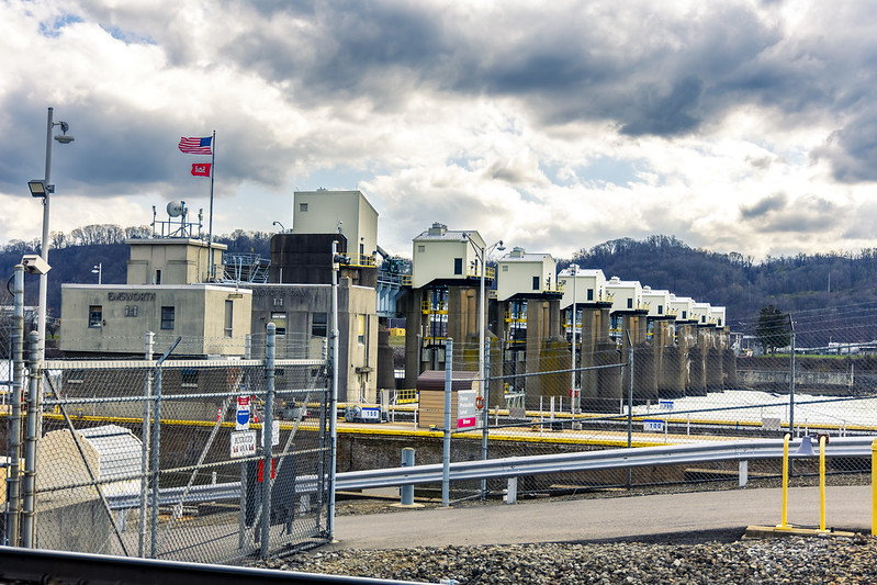
After visiting Emsworth Locks and Dam along the Ohio River, located just outside Pittsburgh, one noticed a plastic box labeled with ‘take one’ that contained xerox flyers proclaiming this spot as being ‘Buzzie’s Corner.’
I haven’t been able to find out too much about this cognomen, but apparently this was, and is, a popular railfanning location. There’s a website: Buzzie’s Corner, but the proprietor thereof confesses their own ignorance as to the origin of the name and whom Buzzie was or is.
I’m reminded of a Staten Island spot on the Kill Van Kull back in NYC which my friends and I started called ‘Skelson’s Office’ in honor of our dearly departed pal John Skelson – a photographer who lived nearby that spent countless hours photographing the parade of maritime vessels exiting and entering Port Elizabeth Newark from a certain spot on the shoreline.
Man, I’ve got a lot of dead friends.
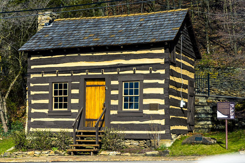
– photo by Mitch Waxman
Historically preserved, restored, and moved from its original location, pictured above is a 1797 vintage log cabin dubbed the Dickson Log House. The Buzzie’s Corner site has a page devoted to its story – check it out here.
Me? It was time to move on to another location and see what could be seen from it. A few miles down the river was found a neat little town which looked a great deal like a fishing village. It was all of two to three blocks in depth, and pavement on its roads stopped about 200 feet from the highway off ramp that took me there. At the very end of an unpaved and muddy road is a small park with a baseball field that sits right along the same Norfolk Southern tracks mentioned yesterday.
I discovered that the end of this road is where the local ‘working guys’ go ‘cribbing,’ meaning that this where they park their trucks while taking a nap at work.
– photo by Mitch Waxman
Still batting zero on the train front, I keyed in the next destination on my phone, and let Google maps guide me to another spot I wanted to check out. A rather circuitous route was laid out for me, which allowed for visual inspection of a nearby suburb. One is often annoyed by the navigational suggestions hereabouts. Google doesn’t seem to take into account that their ‘shorter by three seconds’ route requires driving up a mountain and back down again when a U or K Turn would have done the job more simply and not burned out a bunch of fuel.
What also annoys me is these sorts of routes send motorists into residential neighborhoods, increasing traffic flow in precisely the areas where you want it to be cut down.
Back tomorrow.
“follow” me on Twitter- @newtownpentacle
Buy a book!
“In the Shadows at Newtown Creek,” an 88 page softcover 8.5×11 magazine format photo book by Mitch Waxman, is now on sale at blurb.com for $30.
Emsworth Lock and Dam
Wednesday
– photo by Mitch Waxman
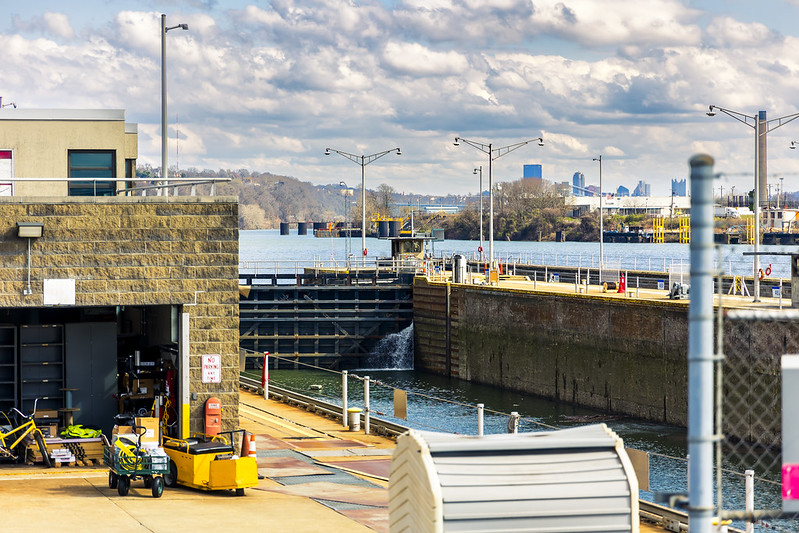
As part of a humble narrator’s continuing exploration of the Pittsburgh metro area, an afternoon in late March found me standing at the fence lines of an United States Army Corps of Engineers installation called the Emsworth Locks and Dam, on the Ohio River. As it turned out, I missed a dramatic set of events here which would occur in early April when an unusually high volume of rainfall caused all sorts of chaos here in the local vicinity.
Hullabaloo, I tell’s ya, hullabaloo.
The Three Rivers overflowed their banks which flooded several waterfront parcels, and here at Emsworth – 26 maritime barges which were tied up upriver that were full of minerals got loose from their moorings, and ended up wedged up against the dam.
Before you ask, I followed my usual policy of staying the hell away from such horrors unless someone was specifically going to be paying me to take the risk, in order to get a photo or deliver a video.
– photo by Mitch Waxman
As mentioned above, this particular afternoon was one of my ‘exploratory trips’ wherein a series of waypoints were encoded into a Google map, which I then followed while driving the Mobile Oppression Platform from place to place. This one wasn’t a walk, it was a drive.
So far, my ‘get out there and see something’ instincts have been drawing me up the Monongahela and Allegheny rivers away from the center of Pittsburgh, with just a few ventures out and along the Ohio.
There’s a series of GPS waypoints which I’ve tagged along this river’s banks – boat launches, public parks, trails, etc. – which I’ve planned on visiting sometime in the near future, or in the case of this week’s posts – now. There’ll come a moment sometime in the future when I’m actually crossing into – y’know, the State of Ohio – which is about a 90 minute drive from Pittsburgh, here in the Commonwealth of Pennsylvania.
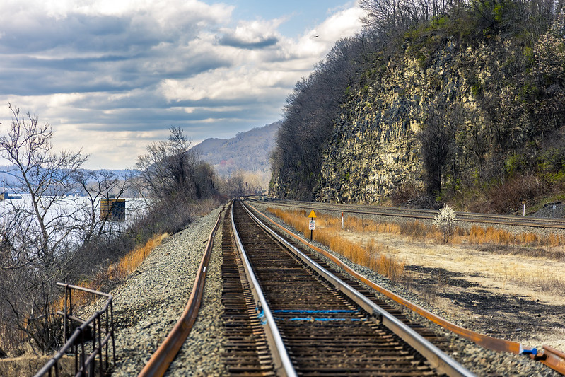
– photo by Mitch Waxman
Along the Ohio River, and this shot is from the northern side of the waterbody, there’s a pretty expansive series of rail tracks which are used by the Norfolk Southern outfit. I was hoping to catch a shot of a passing train when I was here, but no such luck was on offer. Have to get myself one of those railfan scanner radios one of these days, so I know if something interesting is coming my way.
Go west, old man.
Back with all that, at this – your Newtown Pentacle, tomorrow.
“follow” me on Twitter- @newtownpentacle
Buy a book!
“In the Shadows at Newtown Creek,” an 88 page softcover 8.5×11 magazine format photo book by Mitch Waxman, is now on sale at blurb.com for $30.


