Archive for the ‘Calvary Cemetery’ Category
rolled down
Down with the night, yo.

– photo by Mitch Waxman
As opined yesterday, the wrought iron fence posts of First Calvary Cemetery are just the right size to stick a camera lens through. In that prior post wherein my keen observational prowess was offered, focus was given to the estimable Kosciuszcko Bridge project, while today’s set of images are a few night shots of the cemetery itself. Unless you are an absolute fanatical maniac on the subject of eating carrots or half Kryptonian, these shots are just a smidge broader than the perceptual range of human vision. The light sources are environmental, incidentally.
All I saw, with the naked eye as it were, was a silhouette of the cemetery against the skyline of the Shining City to the west.

– photo by Mitch Waxman
There were a few examples of the long exposures one returned to HQ with, wherein the camera’s sensitivity to light was enhanced in different ways, which rendered out as sort of cartoonish, and overexposed the lit up Manhattan skyline into a white blob. Saying that, I was able to reclaim an excruciating amount of detail from the shadowed areas but the images were in “the uncanny valley,” meaning that they looked utterly fake and overtly “digital.”
You can’t put a landscape picture of Calvary Cemetery up on the web without some recognizable part of the skyline in it, as a note.

– photo by Mitch Waxman
On Laurel Hill Blvd., here at the angle between Industrial Maspeth and Blissville, however – if you “go wide” the section of Manhattan between the Battery and 57th street can all be captured in one shot.
“follow” me on Twitter- @newtownpentacle
luring skylines
Only the lonely…

– photo by Mitch Waxman
Girt in filthy black outer wear, with camera dangling, recent endeavor found a humble narrator scuttling in the general direction of Bushwick from Astoria. Crossing the Newtown Creek at just the right spot is critical, as the various street grids of the ancient communities which surround it are often at odds with each other and can be described as dangerously heterogenous. Walk over the wrong bridge and you could have easily added a half hour to the journey.
In the case of walking from Astoria to Bushwick, the best path to follow is actually one through Sunnyside, Woodside, and Maspeth. You want to aim yourself at the Grand Street Bridge, where you’ll get a nice view of the Koscisuzcko Bridge if you get there at the right time of day.

– photo by Mitch Waxman
Using knowledge of the old municipal grids which signified the borders of the independent towns and villages, one threw himself inexorably south and east. Crossing the former Thomson Avenue, now called Queens Blvd., nearby its intersection with Greenpoint/Roosevelt Avenue vouchsafed me passage out of the street pattern of the Middleburgh section of Long Island City now known as Sunnyside. The natural turn one would make at this point is about ten blocks eastwards at 58th street nearby the so called “Big Six” buildings, which is less than pedestrian friendly and visually “meh.”

– photo by Mitch Waxman
Instead, one cut through the funereal properties of the Roman Catholic Church called “Second Calvary Cemetery,” a path which guaranteed one a bit of quietude and solace. One always feels at home amongst the tomb legions, for their condemnations and judgment are always silent. There are four Calvary Cemeteries, by the way, which share common supervision under an organization called “the Trustees of Old St. Patrick’s cathedral.” The local manager – over the groundskeepers, interments, office, and all other existential issues is provided by a fellow named Joe.

– photo by Mitch Waxman
As is the case with many cemeteries in Queens, a highway bisects the property. In this case, it’s the Brooklyn Queens Expressway, and although the local street below it has no street signs or other demarcations – it’s Laurel Hill Blvd. The Calvary’s on the southern extent of the highway are Calvary #’s three and four. You end up on 58th street anyway, at the end of this street, where a southern or right turn is exacted. You’re still in Woodside at this point, incidentally.
The sidewalks stop about halfway between 58th street’s two corners, and it’s a long block between the BQE and the Long Island Expressway, I tell ya, and there ain’t no sidewalks for most of it.

– photo by Mitch Waxman
Along 58th, on the east side of the street, is Mount Zion cemetery. Third Calvary is across the road, on the west side. Mount Zion is a Jewish cemetery, and was primarily set up for folks who lived on the crowded Lower East side of lower Manhattan. This graveyard uses every possible square inch of space for interments.

– photo by Mitch Waxman
It was on 58th street, along the wrought iron gates of Mount Zion Cemetery, that the latest trophy of the Queens Cobbler was observed. The Queens Cobbler is – of course – a local serial killer who leaves behind single shoes as ghastly trophies of his or her nefarious activities.
One couldn’t linger though, as a particular form of psychological torment was awaiting me in Bushwick and I didn’t want to be late.
“follow” me on Twitter- @newtownpentacle
familiar rookery
It’s National Eat a Red Apple Day, in these United States.

– photo by Mitch Waxman
The holiday season arrives at Newtown Creek in a manner alien to the neighborhoods surrounding it.
Hereabouts it’s truck tires roasting on a open fire, and that ain’t Jack Frost nipping at your nose kiddo, it’s benzene. Reviewing my year end list of; all the mistakes I’ve newly made, people I’ve offended, stupid things I’ve said in public, or generally humiliated myself somehow – it occurred that I hadn’t checked in on things in DUKBO (Down Under the Kosciuszcko Bridge Onramp) in about a month.
That’s the scene, above, at the spot where Review Avenue transmogrifies into Laurel Hill Blvd. at Penny Bridge, in the Blissville section of Long Island City, in the Borough of Queens.

– photo by Mitch Waxman
Long time readers of this – your Newtown Pentacle – will tell you that this bridge replacement project has been explored before.
Documenting this project has been a long standing project of mine – this 2012 post tells you everything you could want to know about Robert Moses, Fiorella LaGuardia, and the origins of the 1939 model Kosciuszcko Bridge. Just before construction started, I swept through both the Brooklyn and Queens sides of Newtown Creek in the area I call “DUKBO” – Down Under the Kosciuszcko Bridge Onramp. Here’s a 2014 post, and another, showing what things used to look like on the Brooklyn side, and one dating back to 2010, and from 2012 discussing the Queens side – this. Construction started, and this 2014 post offers a look at things. There’s shots from the water of Newtown Creek, in this June 2015 post, and in this September 2015 post, which shows the bridge support towers rising. Additionally, this post from March of 2016 detailed the action on the Queens side. Most recently, here’s one from May of 2016, and one from June of the same year. Here’s one from August of 2016, the December 2016 one, one from March of 2017 which discusses the demolition of the 1939 bridge.
Here’s a post showing what I saw during a pre opening walk through in early April of 2017, and the fanfare surrounding the opening of half of the new bridge in April of 2017, a walk through of the Brooklyn side job site in June of 2017. Here’s some night shots from early July of 2017. A series of posts focused in on the removal of the central truss of the 1939 bridge from the summer of 2017 – a timelapse, some stills, and the barging out of the truss.
Most recently, in late September of 2017, a final series of shots of the old bridge were captured in this post. Acquisition of a souvenir chunk of steel from the 1939 bridge was described in this post, and a video of the “energetic felling” of the approaches on October 1st was offered in this one. Still shots and views of the aftermath from the waters of Newtown Creek from later in the day on Oct. 1 are found in this posting, and the aftermath of the demolition as seen from Calvary Cemetery in LIC’s Blissville section in this post from October 5th.

– photo by Mitch Waxman
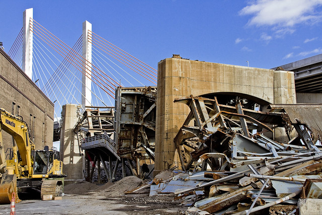
They’re still hard at work demolishing the rubble left behind by the “energetic felling” of the 1939 model Kosciuszcko Bridge at the start of October. These shots were captured from the hills of Calvary Cemetery, if you haven’t already figured that one out yet.

– photo by Mitch Waxman
The reinforced concrete piers that carried the roadway are being demolished using traditional means. That involves the yellow thingamabob being equipped with a chisel hammer, and the guy on the orange lift is spraying water on the concrete to mitigate dust.
The shots of the Queens side of DUKBO in today’s post were shot on November 17th, a Friday.

– photo by Mitch Waxman
On the following Sunday the 19th, a humble narrator scuttled over to the Poison Cauldron in Greenpoint.
That’s my pet name for the section of DUKBO that begins at Kingsland Avenue and heads east past Meeker Avenue to the National Grid fencelines at Lombardy Street. It’s ugly in the Poison Cauldron, I tell you, ugly. Things can’t “get from bad to worse” because they’re already there.

– photo by Mitch Waxman
Similar industrial demolition and scrap removal practices to those in Queens are also occurring on the Brooklyn side. Unlike the Queens side, however, I was able to walk right up to and on the job site. I even used one of the Porta Potties they had stationed to blow some internal ballast (hey, it’s a fairly long walk from Astoria).
– photo by Mitch Waxman
It is odd for me to see light in this spot… this was always an area permeated by shadows, which I now long for.
Additionally, not being chased, threatened, or harassed by the questionable managers of a local waste transfer station as to “whatchu takin pictchas of asshole, getdafukouttaherre” – said operation having been displaced by the construction activity – was not missed at all.

– photo by Mitch Waxman
The only thing going through my mind was that this scene looked like a battle had been fought here.

– photo by Mitch Waxman
I’m sure I’ll have a bit more to tell you about the Kosciuszcko Bridge shortly, as there’s supposed to be a meeting of the Stakeholders Committee coming up in early December.

– photo by Mitch Waxman
There was only so far I wanted to go, as this was and is an active demolition site.
Luckily, that’s what zoom lenses are for.

– photo by Mitch Waxman
The things you see along the Newtown Creek…

– photo by Mitch Waxman
… if you don’t take pictures of them, nobody would believe you.
How can such a place be real, and that so few people even know it exists, this omphalos of New York City?
Upcoming Tours and events
Calvary Cemetery Walking Tour, with Atlas Obscura – Sunday, December 10th, 11 a.m. – 1 p.m.
Explore NYC history, hidden inside sculptural monuments and mafioso grave sites, as you take in iconic city views on this walking tour, with Newtown Creek Alliance Historian Mitch Waxman – details here.
“follow” me on Twitter- @newtownpentacle
trial records
It’s National Spicy Hermit Cookie Day, in these United States.

– photo by Mitch Waxman
A variety of obligations and impediments have caused one to come up short on content this week. As is my custom, accordingly, whilst a humble narrator is out perambulating about the great city seeking to ameliorate his shortcomings – single shots which I like for one reason or another will be presented at this – your Newtown Pentacle.
Pictured above – a shot of one of the groundling burrowers at Calvary Cemetery.
Upcoming Tours and events
Calvary Cemetery Walking Tour, with Atlas Obscura – Sunday, December 10th, 11 a.m. – 1 p.m.
Explore NYC history, hidden inside sculptural monuments and mafioso grave sites, as you take in iconic city views on this walking tour, with Newtown Creek Alliance Historian Mitch Waxman – details here.
“follow” me on Twitter- @newtownpentacle
local inquisitiveness
There is no National Food day on October 5th!

– photo by Mitch Waxman
As promised in Tuesday’s post, one headed over to Calvary Cemetery in the Blissville section of Long Island City to check out the scene after the October 1st “energetic felling” or demolition of the approaches of the Koscisuzcko Bridge. Given that Laurel Hill, which Calvary Cemetery is carved into, offers some altitude and commanding views of the bridge(s) it’s a pretty good choice as far as “point of view.”

– photo by Mitch Waxman
Long time readers of this – your Newtown Pentacle – will tell you that this bridge replacement project has been explored before.
Documenting this project has been a long standing project of mine – this 2012 post tells you everything you could want to know about Robert Moses, Fiorella LaGuardia, and the origins of the 1939 model Kosciuszcko Bridge. Just before construction started, I swept through both the Brooklyn and Queens sides of Newtown Creek in the area I call “DUKBO” – Down Under the Kosciuszcko Bridge Onramp. Here’s a 2014 post, and another, showing what things used to look like on the Brooklyn side, and one dating back to 2010, and from 2012 discussing the Queens side – this. Construction started, and this 2014 post offers a look at things. There’s shots from the water of Newtown Creek, in this June 2015 post, and in this September 2015 post, which shows the bridge support towers rising. Additionally, this post from March of 2016 detailed the action on the Queens side. Most recently, here’s one from May of 2016, and one from June of the same year. Here’s one from August of 2016, the December 2016 one, one from March of 2017 which discusses the demolition of the 1939 bridge.
Here’s a post showing what I saw during a pre opening walk through in early April of 2017, and the fanfare surrounding the opening of half of the new bridge in April of 2017, a walk through of the Brooklyn side job site in June of 2017. Here’s some night shots from early July of 2017. A series of posts focused in on the removal of the central truss of the 1939 bridge from the summer of 2017 – a timelapse, some stills, and the barging out of the truss.
Most recently, in late September of 2017, a final series of shots of the old bridge were captured in this post. Acquisition of a souvenir chunk of steel from the 1939 bridge was described in this post, and a video of the “energetic felling” of the approaches on October 1st was offered in this one. Still shots and views of the aftermath from the waters of Newtown Creek from later in the day on Oct. 1 are found in this posting.

– photo by Mitch Waxman
On the south side of the job site, the Breeze company’s demolition crews are hard at work, and they were chipping and grinding away at a section which must be blocking the Lower Montauk tracks and the LIRR’s right of way. This section of the tracks is known as “dead man’s curve” due to it having been the site of the legendary Blissville Rail disaster and for the number of laborers employed by the now vacated Phelps Dodge company who thought that they could outrun a freight train.

– photo by Mitch Waxman
It is somewhat surreal, this current landscape in DUKBO. This view is looking north towards Sunnyside’s 43rd street, which is found on the other side of the Long Island Expressway viaduct that forms a shield wall between the industrial zone and the residential neighborhoods.

– photo by Mitch Waxman
This view is looking eastwards towards West Maspeth, from a prominence inside the cemetery.

– photo by Mitch Waxman
Here’s a link to a FAR larger incarnation of the stitched panorama above, which captures the entire scene. This is a HUGE file, for those of you reading this on your phones, btw.

– photo by Mitch Waxman
I promise this will be the last Kosciuszcko Bridge post for a bit. In my defense though, in my roll as Newtown Creek Alliance Historian, part of my “job” is to record the events of the Superfund era and to document the seismic changes happening along the fabulous Newtown Creek for posterity.
Upcoming Tours and event
Exploring Long Island City, from Luxury Waterfront to Abandoned Factories Walking Tour,
with NY Adventure Club – Saturday, October 7th, 1 p.m. – 3 p.m.
Long Island City is a tale of two cities; one filled with glittering water-front skyscrapers and manicured parks, and the other, a highly active ground transportation & distribution zone vital to the New York economy — which will prevail? With Newtown Creek Alliance Historian Mitch Waxman – details here.
The Hidden Harbors Of Staten Island Boat Tour,
with Working Harbor Committee – Sunday, October 15th, 2 p.m. – 4 p.m.
A very cool boat tour that visits two of the maritime industrial waterways of New York Harbor which adjoin Staten Island and Bayonne in New Jersey – The Kill Van Kull and the Arthur Kill. There will be lots of tugboats, cargo docks, and you’ll get to see multiple bridges from the water – including the brand new Goethals Bridge. I’ll be on the mike, narrating with WHC board member Gordon Cooper – details here.
“follow” me on Twitter- @newtownpentacle


