Archive for the ‘Dutch Kills’ Category
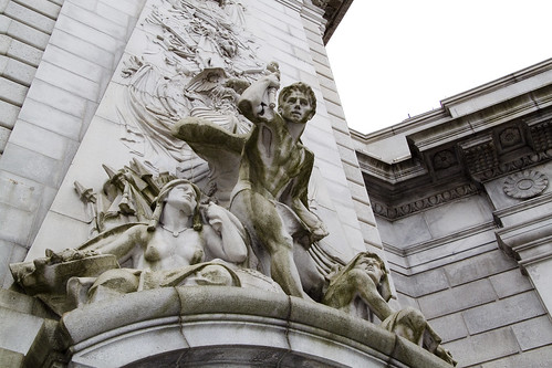
with palpitant heart

– photo by Mitch Waxman
Startlingly interesting is the only way to describe the experiences of the preceding year. Attempts have been made to cogently describe and colorfully illustrate the encounters your humble narrator has enjoyed in this 10th year of the millennium. For those of you who have just recently started to read this, your Newtown Pentacle, this is your chance to check out some of the highlights of 2010 (according to me), and for the veteran Lords and Ladies of the Pentacle an opportunity to review.
If you’ll indulge me…
January, 2010- The Abbot

The sort of posting which satisfies me deeply, “The Abbot” monument found at Calvary focused my attentions on certain realities of 19th century New York, and proved my theory that Calvary Cemetery is the single greatest historical resource in Queens. Obviation of my satisfaction with the posting is provided by the admission that I had noticed the stone peripherally, found it interesting, and started shooting it with no idea at all about its meaning. Only at home, when reviewing the photos did the whole story come together. Al Smith is buried at Calvary as well (he’s the fellow who built the skyscraper seen in the night shot at the head of this post) but this paragraph is about January 2010 and Governor Smith’s story was told in 2009.
January, 2010- The Great Machine

Also in January, a pet ideation was advanced, one not of theory but of perception. The notion of the megalopolis figures heavily in my thinking- a concept that sees the eastern seaboard of the United States not as a series of cities, but rather one vast urban zone of varying densities with New York City at the titular center of a web of industry, transport, and agricultural systems. The center of the web has a center itself, which is Manhattan- specifically where it connects to “the Great Machine” of the Queensboro bridge and it’s corollaries.

– photo by Mitch Waxman
February 2010– Affordable Housing Development on Borden Avenue

This post, “Affordable Housing Development on Borden Avenue“, is included in the year end wrap up simply because it ended up being one of the more widely read and commented upon endeavors presented in 2010. Most likely, it was the linking shout out from Queenscrap that made it so, rather than any subjective quality or incisive observation. Homeless camps abound in the Newtown Pentacle, hidden away on seldom trodden lanes and along backwater pathways- in this case it’s alongside the oft delayed construction project at the Borden Avenue Bridge which spans Dutch Kills.
February 2010– horrible and unearthly ululations…

A lot of time was spent in 2010 trying to wrap my head fully around the story of the Newtown Creek (which culminated ultimately in the late October release of the first Newtown Pentacle book- Newtown Creek for the vulgarly curious) and “horrible and unearthly ululations…” was the first of several posts which attempted to boil complicated and obscure snippets of historical lore into a cohesive and accessible form. So much is made of the Greenpoint Oil Spill and the Meeker Avenue Plumes by the legal community, whose hungry jowls slaver and shake at the financial possibilities offered by the EPA’s superfund designation and various court decisions, that the true and terrible wonder of the Newtown Creek is often overlooked. This post and several others of its ilk attempt to present a fuller version of things, and act as reminders that what was may once again be.

– photo by Mitch Waxman
March 2010– The Shadow over Sunnyside

The St. Pat’s Day for All parade in Sunnyside is a yearly event which draws in a citywide coterie of political entities, all desperate for attention and attribution as being friendly to the GLTG members of the electorate. The parades origins are a reaction against the banning of outwardly gay marchers in the RC church’s own St. Patricks day parade in Manhattan. Despite its politically contentious birthing, the Sunnyside parade is actually a fun and light hearted event, and signals the coming of springtime in the Newtown Pentacle. While there principally to get shots of the political master race which rules over us, amongst the crowd I noticed small clots of dire intent armed with ugly signage. Research into this group, which was clearly coordinated and queerly ominous, revealed them to be adherents to a bastardized form of Catholic fundamentalism which has been outlawed and defined as a dangerous cult by several Nation-states. A shadow over Sunnyside indeed.
March 2010– Exhausted
A brighter experience for your humble narrator was the Manhattan Bridge Centennial Time Capsule event, on March 5. Interactions and conversations were enjoyed by the least of men with certain powers and potentates of the City of Greater New York and entry to the interior space of the Manhattan Bridge was obtained. One of the high points of my year, “Exhausted” detailed the embedding of a time capsule in the East River Bridge #2- aka the Manhattan Bridge. Remarkable self control was exercised when I met the DOT Commissioner, Jeanette Sadik-Khan. My sincerest desire was to bend her ear with my alleged wisdom about bike lanes and bridge safety- but self control was ascendent that day and only congratulations were offered to both her and the other staffers at DOT.

– photo by Mitch Waxman
April 2010– City of Marble and Beryl
Odd shenanigans were observed at St. Michael’s Cemetery here in Astoria, which were of a decidedly magickal nature. A ritual site that your humble narrator stumbled across was examined and evidentiary examination suggested that certain third world cults were extant here in the old village of Astoria, conducting midnight bacchanals concurrent with the lunar cycle. “City of Marble and Beryl” was but the first of many moons which witnessed a working of will amongst the desolations of our kind.
April 2010– Searching for Gilman

A good part of 2010 was spent “Searching for Gilman” at First Calvary Cemetery, which I am doing as you are reading this, assuming it’s the start of 2011 whenever you do. Gilman is the source of no small amount of pain and financial hardship around these parts, as your humble narrator has become dangerously obsessive and paranoid around the subject. A psychotic need to find Gilman’s grave torments me, coloring my days and painting my dreams a dull yellow.

– photo by Mitch Waxman
May 2010– the king in yellow, brick
Remiss would be apparent were I to not mention the “Madison Avenue Bridge Centennial” but “the king in yellow, brick” advanced another of my pet theories and served up a fascinating (to me at least) sequence of events and relationships which attempts to explain why those yellow Kreischer bricks are all over the older sections of Queens.
May 2010– after cycles incalculable

“After cycles incalculable” is another one of those perfect posts, from a personal perspective. Wandering around with a friend, which is a disturbing trend which developed over the course of 2010, at Skillman Avenue’s start we observed the Lemuria hatching in concordance with the anniversary of the Roman festival of Lemuralia in Long Island City.

– photo by Mitch Waxman
June 2010– from Hells Gate, loosed upon the world

When I set out on my little walks, there is seldom a destination in mind. Literally wandering, obscure symbols and pseudo occultism guide my steps- I’ll follow a black cat, or merely adopt a roughly heliotropic path using my own shadow as compass. At the very end of May, my feet carried me toward Astoria Park and the notorious section of the East River known as Hells Gate. The odd craft, an “unidentified floating object” if you would, which sped past my lens required more than a small bit of detective work to identify- which was detailed in “from Hells Gate, loosed upon the world“.
June 2010– Gods Gift to Pain

English Kills, which is the logical and modern end of Newtown Creek, is a heavily industrialized and largely anaerobic tributary of the larger waterway and is seldom visited (by me, at least) at its extant. One fine day, while hanging out with another Creek enthusiast (you should not go to this place alone), we decided to enter the largely hidden urban foyer which leads here- despite the fact that we were most likely trespassing- which violates Newtown Pentacle policy. The title of the post- “Gods Gift to Pain” was lifted from an enigmatic and appropriate bit of graffiti observed in this forgotten pace of dissolution and poison.

– photo by Mitch Waxman
The reason for Brooklyn, and Queens- why it was a viable alternative to living in Manhattan in the 19th century was defined by the horrors of tenement life. The grand old buildings with their high ceilings, thick plastered walls, convenient dumbwaiters, and incredibly ornate lobbies- the structures which distinguished and made life desirable in the incalculably distant boroughs, were built as an alternative to the crowded and dangerous tenements of “The City”- especially the warren which was known as the “Five Points“. Additionally, Calvary Cemetery (of particular interest to me, and perhaps, to you) was founded by the parishioners of Old St. Patrick’s Cathedral which is smack dab in the middle of this ancient labyrinth of poverty, crime, and squalor. It was decided that to fully understand what one observes in the remains of the supposed “answer to the problem”, exploration of “the problem” itself is required.
July 2010– Bandits Roost, 2010

Ideal source material for the textural and societal milieu of the Five Points is the admittedly biased “How the Other Half Lives” by 19th century do-gooder Jacob Riis. Speaking the truth that power wants to hear is always a sound move if one considers fiscal realities and historical reputation. Attempts were made to find the modern locale in which Riis shot some of his more famous shots, such as this visit to “Bandits Roost 2010“.
July 2010– The house of Dagger John

Another critical visitation for me, as part of my larger education and study of the early development of the City of Greater New York was occasioned on the day when I went to “The house of Dagger John“. Old St. Patrick’s Cathedral satisfies both my continuing fascination with the counterpoint of sacred and profane in the story of the Megalopolis, and figures largely in the predictions of certain obscure lore which governs the schedule of my researches.

– photo by Mitch Waxman
August 2010– not to harsh anyone’s buzz… but…

August of 2010 brought a posting which garnered a lot of attention, due to curbed.com noticing and linking to it. Simply noticing that a growing proliferation of small boats were berthing illegally at the Vernon Avenue street end, it would be irresponsible of me- given everything that I know about the location not to point out the mortal and existential danger that the operators of these boats were placing themselves in. It’s not even the water, really, its the high pressure natural gas line- the enormous CSO which drains LIC- the omnipresent heavy industrial maritime traffic- which makes the spot so hazardous. Mortal threats were received via email (which I’ve kept private), and the comments thread displayed an angry and accusatory tone. As is the case with all such critique, these comments were presented verbatim- here’s a taste: “i have red your article in which you show a great deal of unger towards me and my friends . i believe that you base your article on many misconceptions that are rooted in a lack of communication”, “Blogger or not, the prudent journalist would make an effort to uncover basic facts before publishing a story full of assumptions”, “are you just the type of little man that tells teacher when the cool kids make you feel inferior. The water is public domain! And according to maritime law it is not illegal to moor a boat as long as it safe and looked after.”, “They are not bothering anyone. And get sick from the canal, come on. They are not living down there as far as I know. Parking your boat in the canal is not going to get them sick! Stop over doing it.” Check out “not to harsh anyone’s buzz… but…“.
August 2010– lively antics

One of the greatest joys of living in Queens are the chance encounters you’ll have with people who hail from the furthest points of the compass, such as this Bouzouki player during another visit to Hells Gate. His “lively antics” added splendor to a brightly lit walk around Astoria.

– photo by Mitch Waxman
September 2010– Lucky Shot

Although veteran photographers caution me against use of this term, I call the photo above my “shot of the year”. The steel structure attached to the bottom of the Brooklyn Bridge was installed as part of a bridge painting and maintenance project, and I was luckily along on a Working Harbor trip just as the sun was setting. Right place, right time, it was a “Lucky Shot“.
September 2010– stronger than fear

The dynamic new Safeboats utilized by NYPD and other entities around the harbor were a frequent subject over several of the Working Harbor expeditions I was lucky enough to attend. The many shapes, colorways, and missions of these quick little patrol boats are a delight to observe- and to those who would work maritime malice upon the metropolis- they are the head of the spear. Check out “stronger than fear“.

– photo by Mitch Waxman
A high of the year was the Newtown Creek Cruise which I had the honor of co-narrating with Bernard Ente on October 24th, of course, but the main topic of conversation amongst the antiquarian and environmental communities of the Newtown Pentacle in October revolved around the EPA’s superfund announcement about Newtown Creek at the very end of September. October is spooky time around these parts, and I spent a little time digging around the area for thrills and chills as well.
October 2010– blurred outlines

As part of series of postings detailing what might be seen in the Brooklyn neighborhood of Greenpoint, “blurred outlines” discusses the alleged appearance of a pyrokinetic at 84 Guernsey Street in January of 1895.
October 2010– scenes familiar, and loved

One of my frequent walks through Calvary Cemetery took me to the curiously empty chapel which enjoys the paramount of Laurel Hill. I will admit that I came here this day seeking two things- one was a likely entrance to a vast subterranean structure which underlies the area- the other was a vain hope that the grave of Gilman might present itself in a section which was, at the time, not terribly familiar to me as I normally stay close to the fringes of the place where the whipporwills wail. I very well might have captured what mass media paranormal media sources describe as a ghost orb in “scenes familiar, and loved“.

– photo by Mitch Waxman
November 2010– peace rests nevermore

One of the goals of this, your Newtown Pentacle, is to provide some sort of documentation about this terrible and wonderful place called the Newtown Creek- and I’m happy to say that I was there when the then Attorney General and Governor Elect Andrew Cuomo announced the settlement of a lawsuit brought by his office on behalf of New York State against Exxon-Mobil which involved the Greenpoint Oil Spill. “Peace rests nevermore” indeed.
November 2010– shocking coruscations

Entertaining maritime folklore from past centuries was offered in “shocking coruscations“, which is told against a series of twilight photos from good old Hells Gate between the two great bridges.

– photo by Mitch Waxman
During the cold, when inclement clime restricts my movements and the black dog nips at my heels, I tend toward shorter postings- and in December of 2010 there were two “Then and Now” postings that really took my fancy. These posts are difficult because of the scarce source material available in the public domain, but fun nevertheless. In my usual fashion “dumb idiot” fashion, I had shot the modern views completely unaware of the original photo. Our friends at the Greater Astoria Historic Society have recently released a book of similar historical views, which is worthy of consideration.
December 2010– Bowery Savings Bank 2010 and 1903

As the title states, this is the iconic shell of a once essential and awesomely powerful institution called the Bowery Savings Bank in Manhattan, with a 1903 photo from a similar perspective.
December 2010– Hunters Point Avenue Bridge Centennial

If you told me a year ago that I’d end up doing a press conference with a United States Congresswoman, I’d have hit you. That’s how I ended up at the Degnon Terminal’s own Sunshine Biscuits (LaGuardia Community College) building though, and by an odd coincidence- found myself standing in nearly the same spot as some unknown photographer did in 1921. This posting was built around the announcement of the “Hunters Point Avenue Bridge Centennial” event.

– photo by Mitch Waxman
Overall, a positive and exciting year, despite the deaths of several members of my family.
For a while, I enjoyed a spot on the board of the nascent Newtown Historical Society as a trustee, which is a position that I’ve had to resign for a variety of personal reasons- but I’d like to thank fellow board members Kevin Walsh, Christina Wilkinson, Steve Garza, and Bob Singleton for an interesting and educational experience. Kevin Walsh of forgotten-ny gets a personal call out, as his support, knowledge, and encouragement has been invaluable. Special thanks also are extended toward Capt. John Doswell and Meg Black of the Working Harbor Committee, all the guys and gals aboard the John J. Harvey fireboat, and everybody else who allowed a piss poor specimen such as myself to come along on adventures. Bernard Ente of the Newtown Creek Alliance, Working Harbor, and others also receives a heartfelt gratitude and shout out from this humble mendicant. Standing on the shoulders of giants is difficult if you suffer from altitude related nosebleeds.
What’s next?
Tell you what, feel like taking a walk?
Meet me at the border of Brooklyn and Queens – bring a camera… and ID… I’ll show you something cool…
A few recent shots from Dutch Kills
– photos by Mitch Waxman
Funny, these shots only represent a duration of a couple of weeks, yet the variation in water condition is remarkable. The odd white goo coating the bottom observed in the first few shots has been reported to me as existing at the Gowanus Canal as well.
I’m going to be taking a little break, as far as hard core posting goes, to accommodate the holidays. Expect a few more slideshows, and some short posts until after the seasons festivities have passed. The winter session at this, your Newtown Pentacle, will officially begin in the new year but for now the posts will be terse but regularly offered.
Today’s holiday, of course, is Festivus.
Hunters Point Avenue Bridge Centennial, Dec. 11

– photo by Mitch Waxman
Gaze upon it, lords and ladies, a risible talisman of permanence amidst an ever changing industrial landscape… The Hunters Point Avenue Bridge.
A recent post was offered for consideration at this, your Newtown Pentacle, which hinted at certain remarkable events about to occur in its environs and discussed a small part of the rather expansive history of this largish bit of motile steel which spans Dutch Kills.
Glory then, in the announcement of a free walking tour celebrating its centennial.
from nycbridges100.org
![]()
NEW YORK CITY BRIDGE CENTENNIAL COMMISSION AND NEWTOWN CREEK ALLIANCE TO HOST WALKING TOUR OVER HUNTERS POINT AVENUE BRIDGE MORNING OF DECEMBER 11TH
The New York City Bridge Centennial Commission (NYC BCC) and Newtown Creek Alliance announced today that they will sponsor a free walking tour of the Hunters Point Avenue Bridge in Long Island City on Saturday, December 11, 2010 at 11 a.m. to celebrate its 100th birthday.
“It’s important to celebrate these milestones as a way to show how much we rely on all these crossings in our day-to-day lives,” said NYC BCC President Sam Schwartz.

– photo by Mitch Waxman
Your tour guides for this centennial event will be Newtown Creek Alliance and Working Harbor Committee’s Bernard Ente, and a certain humble narrator will be assisting him in meager ways.
This location is awfully close to both legendary Greenpoint and to the heart of Long Island City, and quite close to Manhattan via subway. Here’s a google map with the location of the Bridge, and the meet-up point at 21st street and Hunters Point Avenue is called out.
from nycbridges100.org
The original Hunters Point Avenue Bridge dates back to 1874 when the bridge was a wooden structure. From 1874 to 1907 an iron bridge was in place before being replaced in 1910 by a double-leaf bascule bridge. It was again rebuilt in the early 1980s as a single-leaf bascule bridge. Bascule bridges are designed with a counterweight that balances the span as it swings upward (a single leaf lifts up from one end while a double leaf lifts up from both sides in the middle of the span).
The bridge is located between 27th and 30th streets in Long Island City and is situated four blocks east of the Borden Avenue Bridge. The span is 21.8 meters long and has two lanes, one in each direction. It has experienced higher traffic volumes over the last year and a half while the Borden Avenue Bridge has been closed for construction in this heavily industrialized area.

– photo by Mitch Waxman
Spectacular views of Dutch Kills, as well as knowledgeable and unbiased narration, can be had for the price of attendance alone. Attendees are advised to bring cameras, as this is a particularly photogenic section of the Newtown Creek watershed.
from nycbridges100.org
![]()
The meeting point for the tour will be at Hunters Point Avenue at 21st Street outside the 7 train station. If you would like to participate, please email tour guide Bernie Ente at info@entephoto.com.
About the NYC Bridge Centennial Commission
The NYC Bridge Centennial Commission is a 501 c 3 non-profit comprised of public and privateorganizations to commemorate the centennials of several NYC bridges and raise infrastructure awareness.
About the Newtown Creek Alliance
The Newtown Creek Alliance represents interests of community residents and local businesses who arededicated to restoring community health and vibrant water dependent commerce along Newtown Creek.

– photo by Mitch Waxman
Dutch Kills is a familiar sight to regular readers of this, your Newtown Pentacle, but must be experienced first hand by all interested in the story of the Newtown Creek. This will not be a rigorous walking experience- sneakers or other comfortable shoes should be sufficient as we won’t be leaving the sidewalk- but if icy conditions occur- use good judgement.
Undoubtedly, it will be cold, and the event will be happening rain, shine, or snow- so gauge your outerwear according to forecasted weather conditions.
For those interested in further discussion with other antiquarians and enthusiasts, we are planning an after event visit to a local diner for coffee, luncheon, and conversation.
from nyc.gov
Hunters Point Avenue is a two-lane local City street in Queens. Hunters Point Avenue is oriented east-west and extends from 21st Street to the Long Island Expressway/Brooklyn Queens Expressway interchange in Queens. The avenue is parallel to and approximately one block south of the Long Island Expressway. The Hunters Point Bridge over Dutch Kills is situated between 27th Street and 30th Street in the Long Island City section of Queens, and is four blocks upstream of the Borden Avenue Bridge. It is a bascule bridge with a span of 21.8m. The general appearance of the bridge has been significantly changed since it was first opened in 1910. The bridge provides a channel with a horizontal clearance of 18.3m and a vertical clearance, in the closed position, of 2.4m at MHW and 4.0m at MLW. The bridge structure carries a two-lane, two-way vehicular roadway with sidewalks on either side. The roadway width is 11.0m, while the sidewalks are 1.8m wide. The width of the approach roadways vary from the width of the bridge roadway. The west approach and east approach roadways are 13.4m and 9.1m, respectively.
The first bridge at this site, a wooden structure, was replaced by an iron bridge in 1874. That bridge was permanently closed in 1907 due to movement of the west abutment, which prevented the draw from closing. It was replaced in 1910 by a double-leaf bascule bridge, designed by the Scherzer Rolling Lift Bridge Company. The bridge was rebuilt in the early 1980′s as a single-leaf bascule, incorporating the foundations of the previous bridge.
Incidentally…
a photo in the same series as the one below was recently exhibited here- in the “from some point in space” posting about Dutch Kills and the Hunters Point Avenue Bridge.
– photo by Mitch Waxman
While doing supplemental research about the place, I came across the following shot embedded in a scanned “google book”, and the two images form an interesting parallel. The BW shot, you see, is from 1921.
Coincidence abounds, but I believe my forebear was shooting from a similar if not same vantage as I would be at some four score and nine years or 24,855 days later.

– Photo from “The Newtown Creek industrial district of New York City By Merchants’ Association of New York. Industrial Bureau”
indefinable odors

– photo by Mitch Waxman
Down by Dutch Kills, one must persevere to maintain some inkling of hope for the future of mankind.
Saying that, however, in its own way Dutch Kills is actually quite a lovely place- as storied industrial centers which have seen better days typically are. A canalized waterway, Dutch Kills is a tributary of that languid cautionary tale known as the Newtown Creek, and has been isolated for several seasons from its principate source by emergency bridge construction and a changing industrial landscape. I’m down here a lot of course, most recently in the “from some point in space” posting of November 3rd, which includes an intriguing set of high elevation shots of the area which I recently managed to capture.
from nyc.gov
Hunters Point Avenue is a two-lane local City street in Queens. Hunters Point Avenue is oriented east-west and extends from 21st Street to the Long Island Expressway/Brooklyn Queens Expressway interchange in Queens. The avenue is parallel to and approximately one block south of the Long Island Expressway. The Hunters Point Bridge over Dutch Kills is situated between 27th Street and 30th Street in the Long Island City section of Queens, and is four blocks upstream of the Borden Avenue Bridge. It is a bascule bridge with a span of 21.8m. The general appearance of the bridge has been significantly changed since it was first opened in 1910. The bridge provides a channel with a horizontal clearance of 18.3m and a vertical clearance, in the closed position, of 2.4m at MHW and 4.0m at MLW. The bridge structure carries a two-lane, two-way vehicular roadway with sidewalks on either side. The roadway width is 11.0m, while the sidewalks are 1.8m wide. The width of the approach roadways vary from the width of the bridge roadway. The west approach and east approach roadways are 13.4m and 9.1m, respectively.
The first bridge at this site, a wooden structure, was replaced by an iron bridge in 1874. That bridge was permanently closed in 1907 due to movement of the west abutment, which prevented the draw from closing. It was replaced in 1910 by a double-leaf bascule bridge, designed by the Scherzer Rolling Lift Bridge Company. The bridge was rebuilt in the early 1980’s as a single-leaf bascule, incorporating the foundations of the previous bridge.

– photo by Mitch Waxman
Seldom commented, the Hunters Point Avenue Bridge segments Dutch Kills neatly, and has done so for nigh on a century now. The marshes and streams which once typified the area before the advance of railroad and vast agglutination of industrial installation are long gone, relegated to subterranean sewers and masonry clad spillways, but a century ago- the Hunters Point Avenue Bridge (and its predecessors) allowed egress between the terrestrial isolation of the Long Island City center and the rest of western Queens.
The NY Times, in 1908, commented that Long Island City might someday be known as “A city of bridges” due to the many crossings over the tributaries of the Newtown Creek and the presence of mighty Queensboro at its center.
from federalregister.gov
The Hunters Point Avenue Bridge, at mile 1.4, over the Dutch Kills has vertical clearances of 8 feet at mean high water and 13 feet at mean low water. The existing regulations for the Hunters Point Avenue Bridge in 33 CFR 117.801(d) require the draw to open on signal if at least a one-hour advance notice is given to the drawtender at the Grand Street/Avenue Bridge, the NYCDOT Radio Hotline, or NYCDOT Bridge Operations Office. In the event the drawtender is at the Roosevelt Island Bridge or the Borden Avenue Bridge, up to an additional half-hour delay may occur.
The bridge owner, the New York City Department of Transportation (NYCDOT), submitted bridge opening log data to the Coast Guard for review. The bridge owner plans to operate these bridges with multiple crews of drawtenders. The two-hour advance notice should allow sufficient time for the crews to operate these bridges due to the close proximity of the bridges to each other. Recent yearly openings have been relatively low which will allow the bridge owner to utilize the roving crew concept and still meet the needs of navigation.

– photo by Mitch Waxman
The Hunters Point Avenue Bridge (the 1910 version) was configured differently than the modern structure when first built, although the original was constructed for some $95,214 from plans by the Scherzer Rolling Lift Bridge Company with the dirty work performed by the Duseath Engineering Company of 114 Liberty St. NY. As you’d imagine, there is a certain logic behind the esoterica presented about this obscure little bridge found in a literal “industrial backwater” in Queens.
But… I can’t tell you what is is yet…
from nysdot.gov
About 1900, most of the Newtown Creek was bulkheaded and occupied by about fifty industrial properties. Undeveloped or less developed sections without bulkheads included Dutch Kills, about 2,000 feet of shoreline in Queens just above Dutch Kills with two LIRR lighterage piers, about 1,000 feet of shoreline in Queens near the Penny Bridge, and about 3,500 feet of shoreline downstream of Maspeth Avenue in Brooklyn.15 Dutch Kills, and the Queens side of Newtown Creek, just upstream of Dutch Kills, were developed circa 1905-1912, largely through the efforts of the Degnon Terminal & Realty Company. The Degnon firm created an industrial park with rail and marine access around Dutch Kills between about Hunters Point and 47th Avenue, Dutch Kills subsequently was included within USACE dredging projects. Without federal assistance, Degnon created a 150-foot-wide channel with 2,400 feet of bulkhead, including a turning basin. To create rail links to the development, Degnon helped the LIRR build a new 1,000-acre freight terminal circa 1907 along Newtown Creek east of Dutch Kills on property bought from Calvary Cemetery, including several short piers intended to handle heavy freight such as brick, coal, lumber, and ice. From this terminal, a private Degnon Terminal Railroad was created, largely through local streets. On newly filled marshy margins of Dutch Kills, Degnon Terminal & Realty promoted industrial development both on and away from the water. One iron works and several large building materials firms occupied the Degnon waterfront by the early 1920s. Reconstruction of the two movable bridges over Dutch Kills circa 1908-10 contributed to these developments. On other Degnon lots, large firms included the American Eveready Company and the American Chiclet Company, respective makers of batteries and candy.16 Facilitating this growth was the construction of the Queensboro Bridge (1909) and the start of the operation of the IRT subway line in 1917.

– photo by Mitch Waxman
Unfortunately, I can’t announce the news yet… Let’s just say that it would be a good idea to leave the 11th of December open, and that Long Island City is terrible in its grandeur during the winter months.
More on this will be forthcoming by the end of the week.
from wikipedia
Edward Byrne began his civil engineering career in 1886 with the New York City Aqueduct Commission on the construction of the Croton Water Supply System. It is of interest that on this project he met Robert Ridgway, who also was destined to become a distinguished engineer and an outstanding civil servant.
From 1889 to the close of 1897, Byrne worked on highways and bridges for the old Department of Public Works of New York City.
On January 1, 1898, he joined the Department of Bridges and began a striking and noteworthy service which ended in November, 1933, with his resignation from the position of Chief Engineer of the Department of Plant and Structures (the successor of the Bridge Department), in order to assume the duties of Chief Engineer of the Triborough Bridge. His thirty-six years of service in the Department of Bridges, and its successor, the Department of Plant and Structures, may be divided into two periods.
Borden Avenue Bridge
During this period, he was in charge of bridge construction and maintenance, supervising the construction of the Willis Avenue Bridge over the Harlem River, the Vernon Avenue Bridge, the Borden Avenue and Hunters Point Bridges over Dutch Kills, and the old bridge over Flushing River.

– photo by Mitch Waxman
Also, as a note:
I get asked all the time what these signs mean, what they indicate, and how seriously they should be regarded. The powers that be don’t make it easy to find out, for despite the “for more information” attribution, the City doesn’t go into much detail at nyc.gov/dep about them. Partly, this is due to the vogue followed by municipal authorities in recent years which allows private contractors to perform public work. The contractor is under no obligation to release their work into the public domain, as government workers are, and many important details about our metropolis ends up hidden behind corporate firewalls.
Here’s a little of the Batman type detection required to penetrate a purposely obtuse subject, which is a skill I’ve been developing over the lifetime of this, your Newtown Pentacle.
Quoting from hydroqual.com
The Bowery Bay WPCP is permitted by the NYSDEC under SPDES permit number NY-0026158. The facility is located at 43-01 Berrian Blvd., Astoria, NY, 11105 in the Astoria section of Queens, on a 34.6 acre site adjacent to the Rikers Island Channel, leading into the Upper East River, bounded by Berrian Blvd. and Steinway Street. The Bowery Bay WPCP serves an area of approximately 16,105 acres in the Northwest section of Queens, including the communities of KewGarden Hills, Rego Park, Forest Hills, Forest Hills Gardens, North Corona, South Corona, Lefrak City, Elmhurst, East Elmhurst, Jackson Heights, Maspeth, Woodside, Sunnyside Gardens, Sunnyside, Hunters Point, Long Island City, Astoria, Astoria Heights, Steinway, Ravenswood, and Roosevelt Island.
and from the same document this text and chart
The Low Level service area contains 46 regulators, of which 19 interconnected regulators discharge to the Newtown Creek during wet weather through the 13 CSOs. Of these 13 CSOs, 6 discharge to the tributary Dutch Kills (BB-004, 009, 010, 026, 040, and 042), and 6 discharge to Newtown Creek(BB-011, 012, 013, 014, 015, and 043). An additional 2-feet, 8-inches x 4-foot outfall, BB-049, is listed in the Bowery Bay WPCP SPDES permit as discharging to Dutch Kills near 21st Street, but no further information is available such as which regulator it is connected to.

lutes and dancing

– photo by Mitch Waxman
Wandering aimlessly across the pattern that underlies the streets of Long Island City, a logical course whose every obstacle is modern, one day I found myself in the Empty Corridor. Not so empty as it used to be, for the continuing diversion of traffic away from the Borden Avenue Bridge funnels vast numbers of vehicles through these streets- some of which are still clad in only their original Belgian Block cobbles.
from wikipedia
Public property
- It is generally legal to photograph or videotape anything and anyone on any public property, with some exceptions.
- Taking a photograph while on an airplane is banned in many places, and many mass transit systems prohibit taking photographs or videos while on board buses or trains or inside of stations. (It is unknown whether such prohibitions are legal, due to transit systems in the United States often being considered public places.) Photography is against Port Authority rules in New York and New Jersey’s PATH Train system. Photography and videography are also prohibited in the U.S. Capitol, in courthouses, and in government buildings housing classified information. Bringing a camera phone into one of these buildings is not permitted either.
- Photographing or videotaping a tourist attraction, whether publicly or privately owned, is generally considered legal, unless explicitly prohibited by posted signs.

– photo by Mitch Waxman
Always on the lookout for intriguing items to photograph, your humble narrator often finds himself in front of scenes such as this one, and possessed by a paradoxical mindset. On one hand, the artwork which adorns this octagonal stop sign is well wrought, and skillfully placed for maximum esthetic value. On the other, this is vandalism- and it creates a dangerous situation regarding the passage of vehicles through a now unmarked intersection.
Further, I’m often at odds with the ideation of taking photos of such displays at all.
from wikipedia
Private property
Photography may be prohibited and/or restricted within an area of property by the property owner. At the same time, a property owner generally cannot restrict the photographing of their property by individuals who are not located within the bounds of the property.
In order to film on someone else’s property, permission must be received from the owner.
Photographing of privately-owned property that is generally open to the public (i.e. retail) is permitted unless explicitly prohibited by posted signs.
Some jurisdictions have laws regarding filming while in a hospital or health care facility. Where permitted, such filming may be useful in gathering evidence in cases of abuse, neglect, or malpractice.

– photo by Mitch Waxman
Public art, even when unsigned, is still considered to be the property of the original artist. Technically speaking, I’m not allowed to “publish” this image without the express permission of the artist and despite the fact that I own the copyright on the image, I can’t transfer or sell it without permission.
Were this posting commercial in nature, in fact, a court of law could assign damages and restitution. Art commissioned and owned by “The State” on behalf of the public is a different matter, and a complicated legal ground that’s ever shifting about. Generally, if it’s owned by the U.S. government and produced before the 1970’s it’s probably in the public domain.
Usually, I just leave this sort of thing to the prolific Ms. Heather over at NY Shitty, as she’s much better at finding new and exciting street art than I and is possessed of a curatorial spirit toward her discoveries.
But this one I couldn’t stop from shooting. Click the image for the larger size, as these are very nicely drawn images.
from wikipedia
Copyright is a set of exclusive rights granted by the law of a jurisdiction to the author or creator of an original work, including the right to copy, distribute and adapt the work. Exceptions and limitations to these rights strive to balance the public interest in the wide distribution of the material produced and to encourage creativity. Exceptions include fair dealing and fair use, and such use does not require the permission of the copyright owner. All other uses require permission and copyright owners can license or permanently transfer or assign their exclusive rights to others. Copyright does not protect ideas, only their expression or fixation. In most jurisdictions, copyright arises upon fixation and does not need to be registered. Copyright protection applies for a specific period of time, after which the work is said to enter the public domain.


