Posts Tagged ‘Hunters Point Avenue Bridge’
joint furlough
Friday

– photo by Mitch Waxman
Back where I belong, like every other piece of wind blown trash in NYC, at Newtown Creek. Specifically, this is the Dutch Kills tributary of the larger waterway, which is found in Long Island City’s Degnon Terminal subsection. This is the turning basin pictured above, wherein one could expect the space required to rotate a tug and barge combination and reverse course back out to the main stem of Newtown Creek and the East River beyond.
What? You think I’m going to purchase a new lens and not bring it here? Pfah. The new lens in question for today’s post is a 35mm f1.8 prime lens.

– photo by Mitch Waxman
The critical factor in purchasing this lens is that it has onboard image stabilization technology, which couples with a different stabilization mechanism inside of the camera body. This combination has been allowing me to pull off handheld shots that I formerly would have needed to use a tripod to achieve. That’s a 1/60th of a second shot above, and the one below is an astounding 1/10th of a second. With my older camera system, I was lucky if 1/80th of a second was possible.
All told, I’m fairly pleased with myself at choosing to invest in the Canon R6 mirrorless system as my primary rig for the next few years.

– photo by Mitch Waxman
As far as “it,” “It” has remained elusive and whereas I’ve hear splashing indications and seen vortexes in the water that indicate something large and heavy had submerged itself, even after several months of looking for “it” I haven’t been able to produce any documentation of “It.”
If “It” is down there, I will get eventually get a shot of it. Just a matter of time and patience, and time spent at the water’s edge here in the heart of the Newtown Pentacle.
Note: I’m writing this and several of the posts you’re going to see for the next week at the beginning of the week of Monday, February 1st. My plan is to continue doing my solo photo walks around LIC and the Newtown Creek in the dead of night as long as that’s feasible. If you continue to see regular updates here, that means everything is kosher as far as health and well being. If the blog stops updating, it means that things have gone badly for a humble narrator.
“follow” me on Twitter- @newtownpentacle
Buy a book!
“In the Shadows at Newtown Creek,” an 88 page softcover 8.5×11 magazine format photo book by Mitch Waxman, is now on sale at blurb.com for $30.
loutish fellow
Thursday

– photo by Mitch Waxman
A humble narrator is taking a break this week, as his anxiety and or stress levels have become absolutely maxed out. Also, I’m working on something rather time consuming that requires 100% of my attention this week since learning the nuances of a new software package is involved. Thusly, you’ll be seeing single shots and regular postings will resume next week.
Pictured above is the Hunters Point Avenue Bridge, spanning the Dutch Kills tributary of Newtown Creek in Long Island City, on a fairly foggy night.
Note: I’m writing this and several of the posts you’re going to see for the next week at the beginning of the week of Monday, October 26th. My plan is to continue doing my solo photo walks around LIC and the Newtown Creek in the dead of night as long as that’s feasible. If you continue to see regular updates here, that means everything is kosher as far as health and well being. If the blog stops updating, it means that things have gone badly for a humble narrator.
“follow” me on Twitter- @newtownpentacle
Buy a book!
“In the Shadows at Newtown Creek,” an 88 page softcover 8.5×11 magazine format photo book by Mitch Waxman, is now on sale at blurb.com for $30.
beldame thrust
Wednesday

– photo by Mitch Waxman
A humble narrator is taking a break this week, as his anxiety and or stress levels have become absolutely maxed out. Also, I’m working on something rather time consuming that requires 100% of my attention this week since learning the nuances of a new software package is involved. Thusly, you’ll be seeing single shots and regular postings will resume next week.
Pictured above is the Dutch Kills tributary of Newtown Creek in Long Island City, where a somewhat minor industrial discharge was noticed as occurring and pouring into the canal.
Note: I’m writing this and several of the posts you’re going to see for the next week at the beginning of the week of Monday, October 26th. My plan is to continue doing my solo photo walks around LIC and the Newtown Creek in the dead of night as long as that’s feasible. If you continue to see regular updates here, that means everything is kosher as far as health and well being. If the blog stops updating, it means that things have gone badly for a humble narrator.
“follow” me on Twitter- @newtownpentacle
Buy a book!
“In the Shadows at Newtown Creek,” an 88 page softcover 8.5×11 magazine format photo book by Mitch Waxman, is now on sale at blurb.com for $30.
correlated causeways
Eleven bridges, one creek.

– photo by Mitch Waxman
Pulaski Bridge is the first span you encounter, when you’ve left the East River and embarked on a journey down the fabulous Newtown Creek. A double bascule drawbridge, and electrically powered, the Pulaski Bridge connects 11th street in Long Island City with McGuinness Blvd. to the south in Brooklyn’s Greenpoint. Built in 1954, the Pulaski Bridge is owned and operated by the New York City Department of Transportation or “NYC DOT.” The Pulaski Bridge carries five lanes of traffic, plus a dedicated bicycle lane and a separate pedestrian pathway. It overflies the Queens Midtown Tunnel and Long Island Expressway, as well as active railroad tracks found on Borden Avenue.

– photo by Mitch Waxman
DB Cabin acts as a gatekeeper to the Dutch Kills tributary of Newtown Creek. It’s a railroad swing bridge owned by the Long Island Railroad, and connects two rail yards – the Wheelspur Yard (to the west, or left in the shot above) and the Blissville Yard – across the water. Both rail yards and the bridge itself are part of the LIRR’s Lower Montauk tracks. DB Cabin dates back to the 1890’s and is in a terrible state of repair. The swing bridge’s motors are nonfunctional, which isolates the Dutch Kills tributary from maritime traffic, and from the rest of the Newtown Creek.

– photo by Mitch Waxman
Cabin M is just to the north of DB Cabin on Dutch Kills, and the single bascule drawbridge connects the Montauk Cutoff with the Blissville Yard mentioned above. The Montauk Cutoff is an elevated track which used to provide a connection between the LIRR’s Main Line tracks at the nearby Sunnyside Yards with the Lower Montauk tracks along the north (or Queens side) shoreline of Newtown Creek. The 2020 Capital Plan just released by the Long Island Railroad’s owner – The MTA – includes funding to demolish Cabin M.

– photo by Mitch Waxman
Borden Avenue Bridge is owned by the NYC DOT, and is one of just two retractile bridges in NYC (the other being the Carroll Street Bridge over the Gowanus Canal). Built in 1908 to replace an earlier wooden drawbridge (1868) at the intersection of Borden Avenue and Dutch Kills, Borden Avenue Bridge received extensive upgrades and structural repairs in 2010 and 2011, and had its electronic components destroyed by flooding during Hurricane Sandy. Another round of repairs and upgrades began in 2019, which included asbestos abatement work.

– photo by Mitch Waxman
The Long Island Expressway is 71 miles long, and is operationally managed in three sections. The Queens Midtown Expressway is how it’s owners, the New York State Department of Transportation, refer to the section found between the Queens Midtown Tunnel and Greenpoint Avenue in Long Island City. This section is elevated, rising to 106 feet above the waters of Dutch Kills. The LIE truss pictured above handles some 87.7 thousand daily vehicle trips, or 32 million annually, to and from Manhattan,
– photo by Mitch Waxman
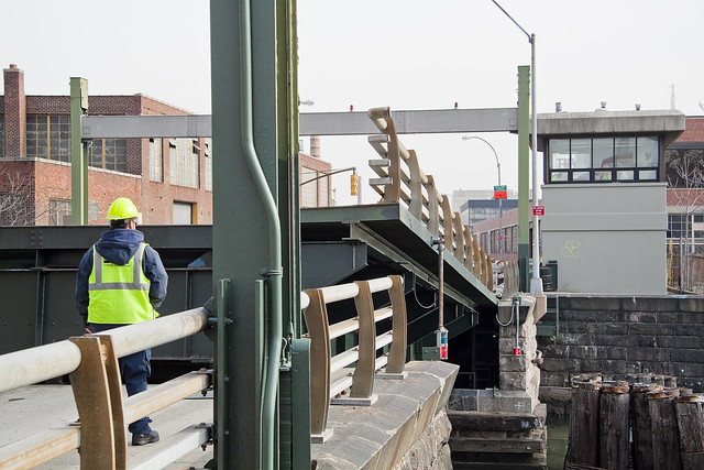
Hunters Point Avenue Bridge is due north west of Borden Avenue Bridge and the LIE truss. It’s a single bascule drawbridge, owned by the NYC DOT. Replacing an earlier wooden draw bridge that was opened and closed by a donkey walking on a wheel, the Hunters Point Avenue Bridge was built in 1910. Back then, it was a double bascule bridge, but a rebuild in the 1980’s simplified the mechanism to a single bascule. The masonry of the bridge is original to the 1910 design.

– photo by Mitch Waxman
The Greenpoint Avenue Bridge is found some 1.37 miles from Newtown Creek’s intersection with the East River, and roughly a half mile from the mouth of Dutch Kills. It’s a double bascule bridge, built in 1987, and owned and operated by the NYC DOT. There have been many Greenpoint Avenue Bridges, dating back to the first one built by Greenpoint’s town father Neziah Bliss back in 1850, but that one was called the “Blissville Bridge.” The Greenpoint Avenue Bridge is a traffic machine, carrying 28.3 thousand vehicle trips a day, or about ten million a year. Most of that traffic takes the form of heavy trucking.

– photo by Mitch Waxman
The brand new Kosciuszko Bridge(s) replaced a 1939 vintage truss bridge that carried the Brooklyn Queens Expressway over Newtown Creek and are found some 2.1 miles from the East River. The NYS DOT is busy putting the finishing touches on the new cable stay bridge’s construction. In addition to the… ahem… high speed traffic lanes of the BQE, there is also a pedestrian and bicycle pathway found on the new Kosciuszko Bridge which connects 43rd street in Queens’s Sunnyside section with Meeker Avenue in Brooklyn’s Greenpoint.

– photo by Mitch Waxman
The Grand Street Bridge is a swing bridge connecting Maspeth’s Grand Avenue in Queens with East Williamsburg/Bushwick’s Grand Street in Brooklyn. 3.1 miles back from the East River, in a section of Newtown Creek once called “White’s Dock,” the NYC DOT have recently announced plans to replace this 1909 beauty – which is actually the third bridge to occupy this spot. Damage from Hurricane Sandy, and the narrow roadways with height restrictions that the bridge offers, have pretty much sealed its fate. It will be missed.
This is where the main spur of Newtown Creek ends, as a note. Directly east is a truncated tributary called the East Branch, and another tributary called English Kills makes a hard turn to the south just before you encounter Grand Street Bridge.

– photo by Mitch Waxman
Metropolitan Avenue Bridge is a double bascule drawbridge that crosses the English Kills tributary of Newtown Creek, and is owned by the NYC DOT. Metropolitan Avenue was originally built as a private toll road in 1813, and the first bridge here was a part of the “Williamsburg and Jamaica Turnpike.” The current Metropolitan Avenue Bridge was built in 1931, although it has received significant alterations in 1976, 1992, 2006, and again in 2015. The 2015 alterations?
You guessed it, Hurricane Sandy strikes again.

– photo by Mitch Waxman
Montrose Avenue Rail Bridge is the final crossing found over the waters of Newtown Creek and its tributaries. Some 3.7 miles back from the East River, it’s the property of the Long Island Railroad and used for freight service on their Bushwick Branch tracks. A truss bridge, or trestle if you must, my understanding of things are that whereas the trackway and parts of the rail bridge date back to approximately 1924… there has been quite a lot of work done on the thing which I have not been able to fully document so rather than fill in blanks with assumptions – I’m just going to say that I don’t know everything… yet.
It’s an active track, it should be mentioned.
“follow” me on Twitter- @newtownpentacle
Buy a book!
“In the Shadows at Newtown Creek,” an 88 page softcover 8.5×11 magazine format photo book by Mitch Waxman, is now on sale at blurb.com for $30.
indefinable odors
“follow” me on Twitter at @newtownpentacle
This is a reblog of the post “indefinable odors“, which focused in on the little commented Hunters Point Avenue Bridge. Sorry for the repeat, fresh and new stuff is in the pipes.

– photo by Mitch Waxman
Down by Dutch Kills, one must persevere to maintain some inkling of hope for the future of mankind.
Saying that, however, in its own way Dutch Kills is actually quite a lovely place- as storied industrial centers which have seen better days typically are. A canalized waterway, Dutch Kills is a tributary of that languid cautionary tale known as the Newtown Creek, and has been isolated for several seasons from its principate source by emergency bridge construction and a changing industrial landscape. I’m down here a lot of course, most recently in the “from some point in space” posting of November 3rd, which includes an intriguing set of high elevation shots of the area which I recently managed to capture.
from nyc.gov
Hunters Point Avenue is a two-lane local City street in Queens. Hunters Point Avenue is oriented east-west and extends from 21st Street to the Long Island Expressway/Brooklyn Queens Expressway interchange in Queens. The avenue is parallel to and approximately one block south of the Long Island Expressway. The Hunters Point Bridge over Dutch Kills is situated between 27th Street and 30th Street in the Long Island City section of Queens, and is four blocks upstream of the Borden Avenue Bridge. It is a bascule bridge with a span of 21.8m. The general appearance of the bridge has been significantly changed since it was first opened in 1910. The bridge provides a channel with a horizontal clearance of 18.3m and a vertical clearance, in the closed position, of 2.4m at MHW and 4.0m at MLW. The bridge structure carries a two-lane, two-way vehicular roadway with sidewalks on either side. The roadway width is 11.0m, while the sidewalks are 1.8m wide. The width of the approach roadways vary from the width of the bridge roadway. The west approach and east approach roadways are 13.4m and 9.1m, respectively.
The first bridge at this site, a wooden structure, was replaced by an iron bridge in 1874. That bridge was permanently closed in 1907 due to movement of the west abutment, which prevented the draw from closing. It was replaced in 1910 by a double-leaf bascule bridge, designed by the Scherzer Rolling Lift Bridge Company. The bridge was rebuilt in the early 1980′s as a single-leaf bascule, incorporating the foundations of the previous bridge.

– photo by Mitch Waxman
Seldom commented, the Hunters Point Avenue Bridge segments Dutch Kills neatly, and has done so for nigh on a century now. The marshes and streams which once typified the area before the advance of railroad and vast agglutination of industrial installation are long gone, relegated to subterranean sewers and masonry clad spillways, but a century ago- the Hunters Point Avenue Bridge (and its predecessors) allowed egress between the terrestrial isolation of the Long Island City center and the rest of western Queens.
The NY Times, in 1908, commented that Long Island City might someday be known as “A city of bridges” due to the many crossings over the tributaries of the Newtown Creek and the presence of mighty Queensboro at its center.
from federalregister.gov
The Hunters Point Avenue Bridge, at mile 1.4, over the Dutch Kills has vertical clearances of 8 feet at mean high water and 13 feet at mean low water. The existing regulations for the Hunters Point Avenue Bridge in 33 CFR 117.801(d) require the draw to open on signal if at least a one-hour advance notice is given to the drawtender at the Grand Street/Avenue Bridge, the NYCDOT Radio Hotline, or NYCDOT Bridge Operations Office. In the event the drawtender is at the Roosevelt Island Bridge or the Borden Avenue Bridge, up to an additional half-hour delay may occur.
The bridge owner, the New York City Department of Transportation (NYCDOT), submitted bridge opening log data to the Coast Guard for review. The bridge owner plans to operate these bridges with multiple crews of drawtenders. The two-hour advance notice should allow sufficient time for the crews to operate these bridges due to the close proximity of the bridges to each other. Recent yearly openings have been relatively low which will allow the bridge owner to utilize the roving crew concept and still meet the needs of navigation.

– photo by Mitch Waxman
The Hunters Point Avenue Bridge (the 1910 version) was configured differently than the modern structure when first built, although the original was constructed for some $95,214 from plans by the Scherzer Rolling Lift Bridge Company with the dirty work performed by the Duseath Engineering Company of 114 Liberty St. NY. As you’d imagine, there is a certain logic behind the esoterica presented about this obscure little bridge found in a literal “industrial backwater” in Queens.
But… I can’t tell you what is is yet… (it was a Bridge centennial parade)
from nysdot.gov
About 1900, most of the Newtown Creek was bulkheaded and occupied by about fifty industrial properties. Undeveloped or less developed sections without bulkheads included Dutch Kills, about 2,000 feet of shoreline in Queens just above Dutch Kills with two LIRR lighterage piers, about 1,000 feet of shoreline in Queens near the Penny Bridge, and about 3,500 feet of shoreline downstream of Maspeth Avenue in Brooklyn.15 Dutch Kills, and the Queens side of Newtown Creek, just upstream of Dutch Kills, were developed circa 1905-1912, largely through the efforts of the Degnon Terminal & Realty Company. The Degnon firm created an industrial park with rail and marine access around Dutch Kills between about Hunters Point and 47th Avenue, Dutch Kills subsequently was included within USACE dredging projects. Without federal assistance, Degnon created a 150-foot-wide channel with 2,400 feet of bulkhead, including a turning basin. To create rail links to the development, Degnon helped the LIRR build a new 1,000-acre freight terminal circa 1907 along Newtown Creek east of Dutch Kills on property bought from Calvary Cemetery, including several short piers intended to handle heavy freight such as brick, coal, lumber, and ice. From this terminal, a private Degnon Terminal Railroad was created, largely through local streets. On newly filled marshy margins of Dutch Kills, Degnon Terminal & Realty promoted industrial development both on and away from the water. One iron works and several large building materials firms occupied the Degnon waterfront by the early 1920s. Reconstruction of the two movable bridges over Dutch Kills circa 1908-10 contributed to these developments. On other Degnon lots, large firms included the American Eveready Company and the American Chiclet Company, respective makers of batteries and candy.16 Facilitating this growth was the construction of the Queensboro Bridge (1909) and the start of the operation of the IRT subway line in 1917.

– photo by Mitch Waxman
Unfortunately, I can’t announce the news yet… Let’s just say that it would be a good idea to leave the 11th of December open, and that Long Island City is terrible in its grandeur during the winter months.
More on this will be forthcoming by the end of the week.
from wikipedia
Edward Byrne began his civil engineering career in 1886 with the New York City Aqueduct Commission on the construction of the Croton Water Supply System. It is of interest that on this project he met Robert Ridgway, who also was destined to become a distinguished engineer and an outstanding civil servant.
From 1889 to the close of 1897, Byrne worked on highways and bridges for the old Department of Public Works of New York City.
On January 1, 1898, he joined the Department of Bridges and began a striking and noteworthy service which ended in November, 1933, with his resignation from the position of Chief Engineer of the Department of Plant and Structures (the successor of the Bridge Department), in order to assume the duties of Chief Engineer of the Triborough Bridge. His thirty-six years of service in the Department of Bridges, and its successor, the Department of Plant and Structures, may be divided into two periods.
Borden Avenue Bridge
During this period, he was in charge of bridge construction and maintenance, supervising the construction of the Willis Avenue Bridge over the Harlem River, the Vernon Avenue Bridge, the Borden Avenue and Hunters Point Bridges over Dutch Kills, and the old bridge over Flushing River.

– photo by Mitch Waxman
Also, as a note:
I get asked all the time what these signs mean, what they indicate, and how seriously they should be regarded. The powers that be don’t make it easy to find out, for despite the “for more information” attribution, the City doesn’t go into much detail at nyc.gov/dep about them. Partly, this is due to the vogue followed by municipal authorities in recent years which allows private contractors to perform public work. The contractor is under no obligation to release their work into the public domain, as government workers are, and many important details about our metropolis ends up hidden behind corporate firewalls.
Here’s a little of the Batman type detection required to penetrate a purposely obtuse subject, which is a skill I’ve been developing over the lifetime of this, your Newtown Pentacle.
Quoting from hydroqual.com
The Bowery Bay WPCP is permitted by the NYSDEC under SPDES permit number NY-0026158. The facility is located at 43-01 Berrian Blvd., Astoria, NY, 11105 in the Astoria section of Queens, on a 34.6 acre site adjacent to the Rikers Island Channel, leading into the Upper East River, bounded by Berrian Blvd. and Steinway Street. The Bowery Bay WPCP serves an area of approximately 16,105 acres in the Northwest section of Queens, including the communities of KewGarden Hills, Rego Park, Forest Hills, Forest Hills Gardens, North Corona, South Corona, Lefrak City, Elmhurst, East Elmhurst, Jackson Heights, Maspeth, Woodside, Sunnyside Gardens, Sunnyside, Hunters Point, Long Island City, Astoria, Astoria Heights, Steinway, Ravenswood, and Roosevelt Island.
and from the same document this text and chart
The Low Level service area contains 46 regulators, of which 19 interconnected regulators discharge to the Newtown Creek during wet weather through the 13 CSOs. Of these 13 CSOs, 6 discharge to the tributary Dutch Kills (BB-004, 009, 010, 026, 040, and 042), and 6 discharge to Newtown Creek(BB-011, 012, 013, 014, 015, and 043). An additional 2-feet, 8-inches x 4-foot outfall, BB-049, is listed in the Bowery Bay WPCP SPDES permit as discharging to Dutch Kills near 21st Street, but no further information is available such as which regulator it is connected to.


