Archive for the ‘East River’ Category
…this one’s for the birds

– photo by Mitch Waxman
Washington, whose actual birthday is on February 22, would have avoided shopping on this holiday- I would think.
Have no doubt that the American Augustus had significant material aspirations and enjoyed a lifestyle that could only be maintained by a subjugate army of slaves, but I’d like to believe that he would be resistant to having his birthday celebrated with a crass and consumerist bacchanal.
I like to think he’d be embarrassed, but as I’m a non-slaver, it’s difficult for me to imagine the mindset of the “founding fathers”.
from wikipedia
Titled Washington’s Birthday, the federal holiday was originally implemented by the United States Congress in 1880 for government offices in the District of Columbia (20 Stat. 277) and expanded in 1885 to include all federal offices (23 Stat. 516). As the first federal holiday to honor an American citizen, the holiday was celebrated on Washington’s actual birthday, February 22. On 1 January 1971, the federal holiday was shifted to the third Monday in February by the Uniform Monday Holiday Act. This date places it between February 15 and 21, which makes the name “Washington’s Birthday” a misnomer, since it never lands on Washington’s actual birthday, February 22. A draft of the Uniform Holidays Bill of 1968 would have renamed the holiday to Presidents’ Day to honor the birthdays of both Washington and Lincoln, but this proposal failed in committee and the bill as voted on and signed into law on 28 June 1968, kept the name Washington’s Birthday.

– photo by Mitch Waxman
February 15th is also Susan B. Anthony‘s birthday, who is at least as important to our republic as its founder. If Washington was indeed Augustus, Anthony was Trajan. Speaking of pagan times, incidentally, today is the third day of Lupercalia – a Roman spring cleaning ritual that is also known as Februa. The particular deity of this ancient rite is Februus– an Etruscan god of malaria- although its the ritual that lends its name to the calendrical month, not the god.
Closer to home, February 15th is also the birthday of a man who sired one of Astoria’s most important families– Heinrich Engelhard Steinweg.
from wikipedia
Because of the unstable political climate in Germany, Steinweg decided to leave the country. He emigrated from Braunschweig to New York City in 1851 with four of his sons, but before leaving he gave the company to his son, Theodor Steinweg. Once in New York, he anglicized his name to Henry E. Steinway, and he and his sons worked for other piano companies until they could establish their own production under the name of Steinway & Sons in 1853.
The overstrung scale in a square piano earned the Steinway Piano first prize at the New York Industrial Fair of 1855.[3] In 1862 they gained the first prize in London in competition with the most eminent makers in Europe; and this victory was followed in 1867 by a similar success at the Universal exposition in Paris. According to Franz Liszt, Anton Rubinstein, and other high authorities, the Steinways have done more to advance the durability, action, and tone-quality of their instruments than any other makers of Europe or America.
He and his wife, Juliane, had seven children: Albert Steinway, Charles H. Steinway, Christian Friedrich Theodor Steinweg, Doretta Steinway, Henry Steinway, Jr., Wilhelmina Steinway and William Steinway.
A walk around Hallet’s Cove
Feel like taking a walk? Bring your camera, and ID…

the grill on the dome light says “the lordship”- photo by Mitch Waxman
Hallet’s Cove is the area surrounding the Noguchi Museum and Socrates Sculpture Garden at the border of Astoria and Ravenswood, although it was once the name for the entire village that became Astoria.
Well known to the residents of modern Queens due to the presence of a warehouse operation called Costco, and to its ancient citizens for the ferries to Blackwells Island and Manhattan- Hallet’s Cove is less well known for its industrial history, and the machinations of real estate interests in the locale are obvious to the knowing eye. The times are a-changing, indeed.
from wikipedia
Beginning in the early 19th century, affluent New Yorkers constructed large residences around 12th and 14th streets, an area that later became known as Astoria Village (now Old Astoria). Hallet’s Cove, founded in 1839 by fur merchant Steven Halsey, was a noted recreational destination and resort for Manhattan’s wealthy.
During the second half of the 1800s, economic and commercial growth brought about increased immigration from German settlers, mostly furniture and cabinet makers. One such settler was Heinrich Engelhard Steinweg, patriarch of the Steinway family who founded the piano company Steinway & Sons in 1853, which today is a worldwide piano company. Afterwards, the Steinways built a sawmill and foundry, as well as a streetcar line. The family eventually established Steinway Village for their workers, a community that provided school instruction in German as well as English.
In 1870, Astoria and several other surrounding villages, including Steinway, were incorporated into Long Island City. Long Island City remained an independent municipality until it was incorporated into New York City in 1898. The area’s farms were turned into housing tracts and street grids to accommodate the growing number of residents.

Socrates Sculpture Park – photo by Mitch Waxman
Socrates Sculpture Park presents the picture that the modern City wants you to believe about these “up and coming” corners of river front property. Middle and upper class citizens improving their minds and bodies in a clean and safe environment of esthetic esteem- the epitome of the physical culture movement’s dreams for the urban environment. Nothing wrong with that, of course, and for sporting pursuits and cookouts- the nearby Rainey Park is available to their coarser neighbors from the Ravenswood or Astoria Houses who might not be interested in Yoga- but the neighborhood is becoming a little too “Ayn Rand” for my tastes. There is another side to this place, of course, off the beaten path.
from wikipedia
Socrates Sculpture Park is an outdoor exhibition space for sculpture. It is located at the intersection of Broadway and Vernon Boulevard in the neighborhood of Long Island City, Queens, New York City, United States, North America. In addition to exhibition space, the park offers an arts education program and job training.

A block away from Socrates Sculpture Park – photo by Mitch Waxman
Aboriginal swamplands were conquered in the late 19th century, as the floods of the Sunswick Creek and the East River were tamed by the enterprise of engineers. The industrial mills and combines of Long Island City and Ravenswood extended all the way to Astoria Point, exploiting the valuable river front. In modernity, this is another corridor of dirty industry being swept aside to make room for an urban population bursting at the seams, with little regard for the past or present. Deemed underutilized, experts have named the area as an industrial relict, better demolished than preserved.
If one leaves the carefully mapped walking paths suggested by city planners, another picture emerges. Generations have quietly made lives here, in noble homes whose architectural influences suggest hints of the nautical culture of eastern Long Island and New England.
from socratessculpturepark.org
Socrates Sculpture Park was an abandoned riverside landfill and illegal dumpsite until 1986 when a coalition of artists and community members, under the leadership of artist Mark di Suvero, transformed it into an open studio and exhibition space for artists and a neighborhood park for local residents. Today it is an internationally renowned outdoor museum and artist residency program that also serves as a vital New York City park offering a wide variety of public services.
This is what the Queens waterfront used to look like, notice the small stature of the buildings, except for the Piano factory, since converted over to Condos.


Horror at Hallet’s Cove- Nelson’s Galvanizing site 2010- photo by Mitch Waxman
Across the Newtown Pentacle, where a speculative real estate bubble has recently burst, empty lots are fenced off from their environs. Unlike the abandoned lots of ground that peppered the landscape of New York in the 1970’s and 80’s before the bubble, these patches of shattered masonry are not abandoned- instead they are being held in reserve for future usage. Rapid demolition of these properties follows the quiet acquisition of said lots, to hasten the building process when economic times are better and to head off environmental or historical concerns about erasing possibly significant structures. In the case of this property, Newtown Pentacle readers may remember an examination of the “Nelson Galvanizing” site- titled “The Horrors of Hallet’s Cove“- and the multiple links to various environmental violations assigned to it by the City and State of New York. This is going to be the home of a future apartment house, incidentally.
photo from the “The Horrors at Hallet’s Cove posting”

Horror at Hallet’s Cove- Nelson’s Galvanizing site 2008 – photo by Mitch Waxman

Vernon Blvd. and Broadway – photo by Mitch Waxman
On the corner of Vernon Blvd. and Broadway, with the aforementioned Sculpture Park at my back, the comical Greenstreets sign on a traffic island- surrounded on all sides by “warehoused” former industrial building sites. Large tracts have been demolished to make way for future construction of multiple story, Manhattan style, apartment houses. Underserved by mass transit as it is, with a sewer system designed in the 1920’s, this is the Hallet’s Cove of 2010.
For the Hallet’s Cove of 1840, click here to check out a map and street necrology from pefagan.com

– photo by Mitch Waxman
Formerly one of the tallest residential buildings in the area, this enigmatic survivor of “the good old days” is dwarfed by the newly built tower rising menacingly some 2 blocks away. Just to make myself clear, I’m not anti anything, and regard such development work as inevitable and completely out of my hands. This angers and frustrates colleagues and friends in the antiquarian community, who view this pragmatism as acknowledging defeat, a tacit surrender to the princes of the city and their claims of oligarchal inevitability. In reality, I’m just trying to see all sides of the story.
Always, I must remain an Outsider.
from nydailynews.com
Undaunted by the floundering housing market, a New Jersey real estate firm is looking to build 2,400 residential units on the Astoria Peninsula, the Daily News has learned.
Lincoln Equities of East Rutherford has a contract to buy five parcels of land once used for manufacturing on First Ave., along the portion of the East River waterfront known as Hallets Cove.
Lincoln plans to bulldoze several warehouses on the land and build five residential buildings, one of which would rise 40 stories, company officials said.
“We don’t know what the market will indicate, but it is our intent to have a blend of rentals and condos,” said Hank Sheinkopf, a prominent Democratic political strategist who has been hired as a spokesman for the project.
The project, known as Hallets Point Development, would require the zoning be changed from manufacturing to residential.
Formal plans, which also could include ground-floor retail space, are expected to be submitted by the end of the year.
The proposal would join a growing list of high-density residential developments under construction or planned for the Long Island City waterfront – a list led by the state’s Queens West megadevelopment in Hunters Point and the city’s proposed Hunters Point South community.
Sheinkopf said 20% of the 2,400 units will be affordable housing, but it was unclear how the prices for the project, which is privately funded, would be determined.

– photo by Mitch Waxman
Ultimately, the shocking scale of these new structures dwarf the surrounding neighborhoods- blocking the panoramic views and open skies of a formerly 2 and 3 story cityscape, where a large structure was 5 stories. Philosophically, I tend to regard LeCorbusier style tower parks (and gated communities on the whole) as anti-democratic and very bad for the future of the Republic, as it tends to isolate political centers away from each other and foists an unsustainable population onto local streets and sewers. Like many of these new towers, parking amenities are planned into the structure, but that too brings more traffic onto the local streets which were not designed to handle the increased load. Quality of life in the City of New York is more than just law and order, lords and ladies of Newtown, it’s streets and sewers and electrical infrastructure.
The Hallets, from the Annals of Newtown
William Hallett, their ancestor, was b. in Dorsetshire, Eng., in 1616, and emigrating to New-England, joined in the settlement of Greenwich, Ct., whence he removed to Long Island, and acquired a large estate at Hellgate. (See pp. 29, 63.) In the fall of 1655 the Indians destroyed his house and plantation at Hallett’s Cove, which induced him to take up his residence at Flushing. Here he was appointed sheriff in 1656, but the same year was deposed by Stuyvesant, fined and imprisoned, for entertaining the Rev. Wm. “VVickenden from Rhode Island, allowing him to preach at his house and receiving the sacrament of the Lord’s Supper from his hands. Disgusted at this treatment, Mr. Hallett, on the revolt of Long Island from the Dutch, warmly advocated the claims of Connecticut ; and, being sent as a delegate to the general court of that colony/he was appointed a commissioner or justice of the peace for Flushing. Afterwards he again located at Hellgate, where he lived to the age of about 90 yrs. He had two sons, William- and Samuel,6 between whom, in 1688, he divided his property in Hellgate Neck.
2.. William Hallett, eldest son of William,1 received that portion of his father’s lands which lay south of the road now forming Greenoak, Welling, and Main streets, and Newtown avenue; which road divided his possessions from those of his brother Samuel on the north

– photo by Mitch Waxman
Shot from the Queensboro Bridge, with mighty Triborough and Hells Gate in the background, that’s Big Allis on the left- just for scale. Hallets Cove, where the Sunswick Creek once drained into the East River, is located roughly across the street from the large new building on the right.

– photo by Mitch Waxman
The strip of bare shoreline, a rarity along the East River, is the actual sandy beach of Hallets Cove. During the summer, kayaks are launched from here- I believe courtesy of the LIC Boathouse– but I may be incorrect. Looking south, one sees Blackwells- oops- I mean Roosevelt Island, and Manhattan commands the horizon. Interesting to some may be the observation that in New York, up until recent times, when an entrepreneur was building a new venture in an existing community, it was expected that other improvements would follow- whether roads, streets, or schools.
from the Greater Astoria Historical Society
HALSEY, Stephen Alling.
He donated a tract of land, 100 by 200 feet, extending from Academy street to First Avenue, for school purposes. A commodious school house was shortly afterwards erected on this site, which is to-day used by the Fourth Ward school. He invested in other property, in almost every instance showing his progressive spirit by laying out streets, grading them, &c. The ferry (then running to 86th street) was owned by him up to 1860, and he it was who placed the first modern ferryboat on the line.
He was a great lover of horticulture, and in the garden in front of Capt. Monson’s house on Fulton street may be seen some of the largest Magnolia trees on Long Island, 75 feet in height, planted by him. He had a particular admiration for shade trees which he gratuitously gave to parties desirous of planting shade trees in front of their property. The fine Elms on Washington street and Perrot Avenue still stand as specimens of his planting.

– photo by Mitch Waxman
Now, I go to a lot of places that most people would consider insane, but the folks at undercity.org have actually been down in the sewers beneath Astoria. Check out their gallery and adventures which truly do answer the question- who can guess what it is, that may be buried down there? – Click here.
The folks from watercourses have been through here as well- check out their Sunswick Creek page, with maps.
also, from the Greater Astoria Historical Society
Sunswick Creek. A drained marsh near the foot of Broadway. Scholars believe it may come from an Indian word “Sunkisq” meaning perhaps “Woman Chief” or “Sachem’s Wife.”

– photo by Mitch Waxman
Finally- check out this nytimes.com 1914 article, which describes following a “forgotten-ny” style mapping and exploration of the city along a path forged by by Sarah Comstock in 1849. The map she followed was called “12 miles around New York” (map at new york public library, of course- and check out Comstock’s “Old roads from the heart of New York” at archive.org). She starts with a journey on the Astoria Ferry from 86th street in Manhattan to Hallet’s point and continues through the Newtown Pentacle all the way to the ancient town of Flushing, as well as other destinations.
as it turns out, treadsoftly, a blog I like, rolled through here at the beginning of the week. Check it out.
A Great Machine

Queensboro Bridge and associated structures- “The Great Machine” – photo by Mitch Waxman
Queensboro, whose steel has cantilevered the flow of traffic to the shining city from the fabled vastness of the Long Island since 1909, is merely the focal point of a polyglot mechanism whose works spread into the east. The backbone of New York City runs through the marshy hillocks of western Queens.
As I’ve said in the past:
Airports, railroad yards, maritime facilities, petrochemical storage and processing, illegal and legal dumping, sewer plants, waste and recycling facilities, cemeteries. The borders of the Newtown Pentacle’s left ventricle are festooned with heavy industry and the toll taken on the health of both land and population is manifest. A vast national agglutination of technologies and a sprawl of transportation arteries stretching across the continent are all centered on Manhattan- which is powered, fed, and flushed by that which may be found around a shimmering ribbon of abnormality called the Newtown Creek.
Light rail (subway) and vehicle traffic focus toward Queens Plaza, and within a three mile radius of this place can be found- the East River subway tunnels, the Midtown Tunnel, multiple ferry docks, and the titan Sunnyside Rail Yard which connects to the Hells Gate Rail Bridge. This “Great Machine” is the motive engine that allows millions to enter and leave Manhattan on a daily and reliable schedule from North Brooklyn, Queens, Suffolk and Nassau Counties. The great endeavor called “The East Side Access Project” and its associated tunneling is also occurring nearby, which will terminate at a planned LIRR station sited for the corner of Queens Blvd. and Skillman Avenue.
from wikipedia:
The Queensboro Bridge, also known as the 59th Street Bridge, is a cantilever bridge over the East River in New York City that was completed in 1909. It connects the neighborhood of Long Island City in the borough of Queens with Manhattan, passing over Roosevelt Island. It carries New York State Route 25 and once carried NY 24 and NY 25A as well.
The Queensboro Bridge is the westernmost of the four East River spans that carry a route number: NY 25 terminates at the west (Manhattan) side of the bridge. It is commonly called the “59th Street Bridge” because its Manhattan end is located between 59th Street and 60th Streets.
The Queensboro Bridge is flanked directly on its northern side by the freestanding Roosevelt Island Tramway.

Queens Blvd. at Skillman Avenue – photo by Mitch Waxman

Queens Plaza multi level elevated train station – photo by Mitch Waxman
When Queensboro was built, it became the fastest way into town and horse drawn wagons still carried manufactured goods from the mill workshops of Long Island City and agricultural products from points East (hauled into LIC by the LIRR) into Manhattan. The subways tracks were attached to the superstructure of the bridge. Trucks replaced the horse wagons, and eventually made the cargo hauling operation unprofitable for the LIRR’s gantry docks at Hunters Point. The automobile route and light rail options also collapsed the old passenger and cargo ferry industry which sailed from LIC and Astoria (especially Hallets Point). As the population of Queens left its cradle in LIC and along the East River shoreline, moving ever eastward toward the open country of Long Island, the narrow streets of ancient Newtown were given over more and more to industry. The Great Machine reached further toward the dawn, straining to carry the ever increasing load.
note and minutiae: sartorial mention by learned experts has informed me that the myriad colors that the steel in Queens Plaza is painted reflects the particular line or system that it was erected to serve.

Queens plaza complex – photo by Mitch Waxman

Queens Blvd. at 32 pl. – photo by Mitch Waxman
Following the machine past Skillman Avenue, as it carefully skirts the titan Sunnyside Railroad Yards and the cyclopean Degnon Terminal, one finds the auspicious origin of Queens Boulevard. A primary local artery with an elevated subway track directly connected to the Queens Plaza complex, Queens Blvd. is a central viaduct of population movement away from Manhattan toward points east. Sunnyside, Flushing, Roosevelt, Corona exist in their modern incarnation because of this structure- which like many parts of New York City- must be considered from those hidden structures beneath the street in addition to the visible sections.
There are thousands of mechanisms down there, cables and pipes and electrical transformers, steel underpinnings of the road itself. Realize the complexity of designing a street that can carry fully loaded modern trucking without collapse or subsidence, absorb the vibration and crushing weight of active subway tracks, and also carry a subterranean network of sewer and wastewater systems that can handle the storm runoff from so many acres of concrete. Of course, this complexity was designed over generations of dedicated improvements, but it boggles the mind to… think about what it is… that may be… buried down there.
for a thorough history of the neighborhoods which lie along this section of Queens Blvd., complete with historic photography- check out the work of the masters at Forgotten-NY

End of Naked Steel, Queens Blvd. – photo by Mitch Waxman
After diverging from the Queens Plaza complex, the steel is soon observed as clad in artistic cement, and its pleasing appearance mirrors a Roman viaduct. Such architectural analogy, referencing the time before Caesar did away with pretense, was an artifice used extensively in the era of Progress. Look at the majesty of Washington DC, the Tweed courthouse in Manhattan, or Speer’s plans for the New Berlin during the reign of the last antichrist.
from wikipedia:
Queens Boulevard was built in the early 20th century to connect the new Queensboro Bridge to central Queens, thereby offering an easy outlet from Manhattan. It was created by linking and expanding already-existing streets, such as Thomson Avenue and Hoffman Boulevard, stubs of which still exist. It was widened along with the digging of the IND Queens Boulevard Line subway tunnels in the 1920s and 1930s, and in 1941, the city proposed converting it into a freeway, as was done with the Van Wyck Expressway, but with the onset of World War II, the plan was never completed.

Queens Blvd. looking west – photo by Mitch Waxman
This line of rail continues eastward, sending offshoots into extant neighborhoods. Enormous numbers transverse this street, so much so that it generates statistical norms that stand in contrast to surrounding streets only a block or two away. There is a high rate of just about every affliction or situational outcome possible along Queens Blvd., probability is altered by sheer force of numbers. Spikes in auto accidents or criminal activity far out of scale with surrounding neighborhoods has garnered the infamous “Boulevard of Death” nomen and results in scaled up traffic and transit police patrols all along the route. It’s a bit of a misnomer, as the “just passing through” population of any 1 block stretch on Queens Blvd. is easily the size of a small town. Subways, manhattan bound traffic, pedestrians, residents, shoppers, workers- fuhgeddabowdit.
from wikipedia:
This street hosts one of the highest numbers of New York City Subway services in the city. At any one time, six services—the E, F, G, R, V, and the 7—all use significant stretches of the right of way; only Broadway (nine services), Sixth Avenue (seven), and Seventh Avenue (seven) in Manhattan and Fulton Street (eight) and Flatbush Avenue (six) in Brooklyn carry more at any one time. In addition, the Q60 bus travels its entire length.

End of the line out in Corona – photo by Mitch Waxman

39th (Beebe) avenue elevated station – photo by Mitch Waxman
Another branch of the Great Machine slinks out of Queens Plaza along Northern Blvd. and turns at 31st street, carrying the N and soon to be defunct W lines. This structure continues into and provides the only rail link for the extant sections of Astoria found beyond the noble stature of Ditmars Blvd. This stop is the first on the line, serving Dutch Kills, and its nascent hospitality industry. Before long, this stop will be a primary port of embarkation for hordes of tourists returning from Manhattan. What will greet them, currently, is a coffee shop/greasy spoon and a series of auto garages. Most of the private homes along this block have shuttered windows and zero tenancy, undoubtedly being stockpiled for future large scale development.
from wikipedia:
The Astoria Line was originally part of the IRT, as a spur off the IRT Queensboro Line, now part of the IRT Flushing Line (which didn’t open to the north until April 21, 1917). The whole Astoria Line north of Queensboro Plaza opened on February 1, 1917, and was used by trains between 42nd Street–Grand Central and Astoria.

N Train on elevated BMT tracks – photo by Mitch Waxman

– photo by Mitch Waxman
This is one of those hotels, a Holiday Inn which was recently completed on 39th Avenue and 29th street. Eccentric in design, it is one of the larger buildings visible in western Queens, but is already being dwarfed by newer construction nearby. Greatest of all, the thing in the Megalith watches from on high, as Queens rises.
The European travel industry is a highly evolved entity, which sells “package holidays” combining lodging and travel into one flat rate. Profit is found by booking airline seats and hotel rooms in bulk, garnering discounts from suppliers, and reselling at a higher price to consumers. Its all very civilized, and results in a very competitive pricing strategy which offers real value. Imagine, a trip to New York, all-inclusive for a flat rate- and staying at a brand new hotel two stops from the Apple Store and Central Park!
Really, I’m not being sarcastic. If you’re going to Europe, buy a ticket for London and then put your trip together there. You’ll end up flying to Italy or Bruges on some crap airline, where the in flight entertainment is a non stop commercial selling duty free booze and you’re surrounded by the recently drunk, but who cares… you’ll save a bundle as compared to the ala carte system. The hotel will be downright crappy too, but you’re only sleeping there- you’re in Europe- go to a museum or something. That’s pretty much how most international tourists think about Hotels, that’s the market- hopefully the Hotel investments at Dutch kills can grab a piece of it. Really, I’m not being sarcastic, Queens needs those jobs, and this conversion is fairly inevitable.
I wish that nothing would ever change, and I’ll miss the quirky edges and small stature of this enigmatic little neighborhood, but nothing is going to stop this transformation. I just hope that artifacts of what once was, like the LIC millstones, can be preserved and experienced by the public.

– photo by Mitch Waxman
In Sunnyside, another rhiozome of the Great Machine juts eastward, carrying the 800 pound gorilla to eastern Long Island. This shot is just down the hill from the Queens Boulevard photo above labeled “Queens Blvd. looking west”, a mere 3 city blocks away. These tracks continue for miles, connecting with the brobdingnagian Jamaica Yard, and provide connections to the furthest reaches of Long Island. The tracks are elevated above the streets, and incorporate a series of bridges to span the local streets transversed. A tremendous amount of construction work is underway- as observed by your humble narrator during these endless explorations on foot- to shore up and cosmetically improve the narrow strips of land which surround the trackways. The properties had become overgrown, shoddy, and a favorite location for illicit activity and homeless camps.
from wikipedia:
The Main Line is a rail line owned and operated by the Long Island Rail Road in the U.S. state of New York. It begins in Long Island City and runs directly across the middle of Long Island, terminating in Greenport approximately 95 miles (153 km) from its starting point. Along the way, the Main Line spawns five branches. These branches, in order from west to east, are:
- Port Washington Branch (at Wood Interlocking in Woodside, Queens)
- Hempstead Branch (at Queens Interlocking along the Queens/Nassau County border)
- Oyster Bay Branch (at Nassau Interlocking in Mineola)
- Port Jefferson Branch (at Divide Interlocking in Hicksville)
- Central Branch (at Beth Interlocking at Bethpage)

entrance to the Sunnyside Yards – photo by Mitch Waxman
An entrance to the Sunnyside Yards offers a cutaway view of this Queens Plaza Great Machine complex, with the greenish steel structure bisecting the photo called to your attention. That’s Steinway Street where it becomes the 39th street (or Harold Avenue) bridge, and crosses over the Sunnyside Yard toward Queens Blvd. which is 2 blocks away ultimately terminating at 51st avenue by the BQE, just across the highway from old Calvary Cemetery which abuts the Newtown Creek. The great mills of Queens were once served by direct rail links to the Sunnyside Yard, Standard Motor’s stark industrial building with its no nonsense “daylight factory” windows is the luminous structure in the lower right corner, the Amtrak Acela barn is center, and the construction projects visible are at Queens Plaza. In the distance, Manhattan.
for a fascinating discussion of the legal status and deep history of the bridges over the Sunnyside yards, check out this article at dlapiper.com

– photo by Mitch Waxman
A garland of former industrial supremacy, the aforementioned Standard Building is just one of the enormous mills that once provided untold numbers of jobs to western Queens. Shadows, one of these giants now houses a Welfare office, and many have been converted to self storage facilities. On Northern Blvd., which is sited upon the ancient Jackson Avenue Turnpike, the Great Machine is underground. Subway tracks and other subterranean features reveal the entire surface here to be an artifice. Look at the entrance to the Sunnyside Yard shot above for the true grade of the land. This is the roof a structure, part of the Great Machine.
This Great Machine- an interconnecting system of bridges, roadways, and rail (along with power plants, sewers, and workers)- is the sum total of billions of hours of labor. When the remains of our civilization are scratched out of the sand in some future desert, one would hope that the collective work represented in this series of structures will merit some mention- a footnote next to the story of Manhattan.
from wikipedia:
NY Route 25A begins at its western terminus at Exit 13 (which is the first exit) off Interstate 495 (the Long Island Expressway) at Long Island City in the New York City borough of Queens. Route 25A is known in this area as 21st Street. As you follow 25A, it becomes Jackson Avenue and is a 4-lane road (and remains a 4-lane road well into Nassau County). Just past the intersection with Queens Boulevard (State Route 25), at the foot of the Queensboro Bridge, 25A becomes Northern Boulevard.
Catherine Turecamo at HellsGate, and camera news

– photo by Mitch Waxman
Technical upgrades have occurred here in Pentacle HQ. A new DSLR, which was quite unaffordable, has been purchased from the unknowable levantines at BH Photo. The trusty Canon G10, in use since its issuance in late 2008, is off to Canon for warranty service owing to the defects that have appeared on its lens. Said scratches seem to originate from the mechanical action of the external housing which are meant to protect the lens element. These scratches have, after shooting some 17,000 exposures in the last year, become quite noticeable and are getting in the way. The G10 will return to Newtown Pentacle service upon repair, and is highly recommended to all for its versatile nature, manual shooting modes, ability to save in RAW format, and crisp lens- although it falls apart in low light and is useless at high ISO speeds. The flash is also pathetic.

– photo by Mitch Waxman
Deciding to take the plunge into the DSLR world, our lady of the Pentacle and myself worked out a budget, and research on what was available in my price point began. Things narrowed to the Nikon D90 and Canon Rebel T1i (or 500D). The Nikon is wielded by a buddy of mine to great effect, and offers the promise of a “full size” sensor. The Nikon ecosystem of accessory lenses and other bits is also a little less expensive than commensurate equipment in the Canon range. The Canon, however, matches the 15 megapixel spec of the G10 (also a Canon) and also offers an operating system that seemed a bit more organic to me. I use a Mac, always have, and have quit jobs that forced me to use a windows PC in the past. Organic matters to me, which is why a Sony camera was never considered. (imho Sony makes the best Hardware-Everything, and the worst software-Everything).

– photo by Mitch Waxman
So, having spent a ton of money I don’t have, the plunge was taken on the Canon T1i and a couple of decent lenses. Of course, this is after “the season” for photography in New York, which is actually most of the time- just not in December and January. Harsh shadow and blown highlights, overcast skies and leaden water- trademarks of the winter sun here in the Newtown Pentacle- the angle and frequency of the light is all wrong except in the early morning and late afternoon. Photography types term this as “golden hour”, which somehow sounds “dirty” to me.
So, on one of the few sunny days enjoyed of late, your humble narrator pulled the filthy black raincoat off its hook and scuttled forth to find what I could find. Hells Gate is always a good choice for experimenting with a new gizmo. Astoria Park is just about as safe these days as you can expect to be when out in public, and there’s always something interesting going on. I shot these with the “long lens”, which is fancy way of saying telephoto.
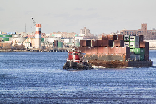
– photo by Mitch Waxman
That’s the Catherine Turecamo, a 1972 vintage 199 ton 3,200 HP tugboat, operated by the Moran towing company. It was built at the Main Iron Works in Louisiana as the MIss Lynn.
from morantug.com
Moran Towing Corporation has provided tugboat services to the Port of New York since 1860. The company began with Michael Moran’s purchase of-one-half interest in a tugboat. In the years since, the fleet with the white M logo on its stacks has become the largest in the port,and on the U.S. East and Gulf Coasts. The port of New York-New Jersey provides access to the most concentrated and affluent consumer market in the world. Its facilities include terminals operated by the Port Authority of NY & NJ and privately operated terminals. Over 16 million tons of cargo pass through the port on an annual basis, transported aboard various types of ships, including container ships, tankers and barges. The New York division also services the Port of Albany, located 145 miles up the Hudson River from New York City. Albany is a hub for commercial trade in its region, due to its proximity to the New York State Barge Canal and its excellent inland transportation network.

– photo by Mitch Waxman
The new camera was a little awkward to handle at first, and I was self conscious of it as well. This was a big “honking” camera, weighing four times what my familiar “rangefinder-sized” G10 did. I practiced tracking the tugboat with it, zooming in and out and so on. I think the shots came out alright- if you click through to the photo’s Flickr page and check out its larger incarnations- you’ll see some real detail in them. This is one of the places where the higher megapixel count of the Canon matters to me, and justified buying into its franchise.
Trust me on this one, I’m an advertising retoucher photoshop guy by day, and resolution matters. A lot.

– photo by Mitch Waxman
I’m only a couple of thousand shots in, a month later. Its been a busy month somehow, with holiday obligation and hiding in my warm burrow awaiting spring. Meanwhile, I’ll be learning how to use this new gizmo.
Incidentally, on the subject of gizmos, anyone out there have anything to say on geotagging? Leave me a comment or contact me, if you do.
In the cold waste 2

from Vernon Blvd., Queensboro – photo by Mitch Waxman
Despite fingertips bleached to parchment white by biting wind and polar conditions, the cold waste beckons, and your humble narrator perseveres.
The relict shores of Ravenswood’s 3rd world persist in atavist glory at Vernon Blvd. and 44th drive, near the Gordon Triangle, which is what passes for a city park in this stronghold of the Oligarchs.
Brutal realities confront one here, 1 and 2 family homes still can be found, abutting vast victorian mill buildings converted to warehouse duty in the early 20th century. Fingerprints, left by the fattened digits of the masters, greasily smear across the neighborhood- every “available” sign on a relict warehouse is a signal of avarice and intent.

Taxis parked – photo by Mitch Waxman
At 46th avenue, the brick horizon opens, and a glimpse of the shining city is offered. Soon, this viewpoint and vantage will be occluded by yet another high rise spire, a warehouse offered to white collar laborers. Where will the unwashed who cook- and clean- and build- live and work when this 3rd world is gone- ground beneath the jeweled heel of progress?
The children of these new residents- where will they play and go to school? What will happen to the fragile infrastructure of 19th century streets, where wounds to the modern asphalt reveal victorian cobblestones? Why is the municipality not requiring the construction of new subway stations and schools, or at least sewers, from these Oligarchs for the rapacious profits they will garner from these grand projects?

Soil remediation tent – photo by Mitch Waxman
All the poisons in the mud will leach out, in the end.
The parable is exemplified at Anable Basin, at 5th street, where a second attempt at remediating the industrial history and unmentioned past of Ravenswood and Hunters Point is underway. This extant of the QueensWest development, whose previous metastasizes eradicated the historic district between the LIRR powerhouse and the LIRR Gantry docks, is troubled by environmental concerns that have postponed the plans of the masters.
Lessons learned there have been incorporated by the municipal chamberlins and chancellors, to avoid such expensive delays in a newer and larger project called Queens South just beginning at Hunters Point.

Megalopolis and Brownfield – photo by Mitch Waxman
Home sweet hell, New York City, the vast human hive.
The cement goddess is mother and home, school and prison, always a battleground- it produces children who are survivalist predators. When we walk the earth, New Yorkers are tigers amongst simpler peoples who didn’t have to endure living with… other New Yorkers.
There is a mind set amongst the rich in New York, and there always has been, that the poor can be saved by example- by having the poor live “as we do”. All of the afflictions of poverty can be alleviated- if not cured. Progressive Reformer or New Law Tenement or Urban Renewal or Gentrification or Upzoning, call it what you want- but Caesar is building the new Roman slums in an entirely inorganic fashion. This neighborhood used to be an industrial center, and then a junkyard, and that’s the reason why the ground is poison.
The industrial revolution happened. Here.

Testing Wells- May 30, 2009 – photo by Mitch Waxman
I am not a fan of vertical tower dwellings whose price of entry is designed to bring a non homologous population into an existing ethnic neighborhood as I can predict what will happen a generation or two from now, but I don’t own the land.
True ownership allows untrammeled discretion- if I own a car, I can set it on fire if I wanted to. If I own a house, I can knock out all the walls if I wanted to. If I could erect a forty story statue of my little dog Zuzu directly across the river from the United Nations building- that would robotically defend the city against giant Cat or Squirrel attack of course- it would be my business- because its my property. Why, though, would the City of New York instead encourage me to build an apartment house on a contaminated site instead of accepting the nature of the place and dedicating it to some acceptable usage? Could it just be the installation of a certain demographic and tax bracket into an overwhelmingly low and middle income neighborhood would benefit the status quo over in Manhattan?
Again, I’m just some guy, who doesn’t own anything. They’re rich guys, and in modern America, rich means you’re right- so what does it matter what I think?

Waste Barrels- June 29, 2009 – photo by Mitch Waxman
I’ve been haunting this place for a while.
Fascinating little project they have going on, which has actually activated some community activism amongst the new residents of Long Island City- the Tower People. Not bad folks these Tower People, on the whole, despite being a denigrated group referred to with smirks and winks by long time LIC’ers. Degreed and lettered professionals on the whole, they are a legion of bankers and lawyers who exist in the warren shadows of Manhattan’s financial district and turbulent midtown by day, but they turn Long Island City from a neighborhood into a dormitory.
A narrow enough lensing of the past can create causality from coincidence, but if you think that Battery Park City or Jersey City is city planning at its best, you’re going to love the new Long Island City.

Brownfield Work Site – photo by Mitch Waxman
The only buy-in for the community at large to enjoy are the production of riverfront parklands, which are remarkable, from which you may admire Manhattan while ignoring Queens stretching out behind you.
A recent article found at Queenscrap describes the cost of maintaining NYC parks at an astounding $10,000 per acre. Using this metric, Calvary Cemetery would need to raise $720,000 per year for groundskeeping, the average suburban golf course would have yearly expenditures measured in the millions, and a midwestern farm would incur costs in the tens of millions to maintain their lands let alone harvest them. I do believe that the journalists out there should take a close look at the Parks Dept. if this number is accurate. Just to be clear, as acreage is an old fashioned measurement not used commonly in the urban setting, that’s a square which is 208 feet and 8 inches on a side. The riverfront parks associated with Queens West will cost as much as $100,000 per acre.

Brownfield Work Site – photo by Mitch Waxman
9.5 acres, and owned by Rockrose Development (which has recently transformed itself into another corporate entity), this is the future home of four residential towers. As of April 2008, some 80,000 tons of contaminants had been removed from the site at a cost of $31 million. Standard Oil sited an oil refinery here in the 1860’s, and the soil is contaminated with Benzene, Petroleum Distillates, and volatile organic chemicals whose detected presence – in trace amounts- would cause the regular NYFD to evacuate and call in their HAZMAT teams.
Additionally, generations of untreated sewage and industrial pollution swirl and mix with the water table of the East River in the deeply cold gravels and blackened mud beneath the place. Sources also reveal that the “clean fill” being used to replace the contaminated substrates that were removed in the remediation process emanates from the tunnel being bored out from under the East River by the “East Side Access” project.
Who can guess, what it is, that still may lie hidden down there?

Brownfield Work Site – photo by Mitch Waxman
All the poisons in the mud will leach out, in the end.


