Archive for the ‘Hudson River’ Category
sixth interest
Tuesday
– photo by Mitch Waxman
More shots from the abandoned Glenwood Power Plant in New York States’ Yonkers municipality in today’s post. For details on the history of the NY Central Railroad, the power plant, etc., please refer to yesterday’s post which is chock full of links.
Very visually interesting place, which I was invited to visit by My Pal Val, who asked me to join in with a group of photographers she was organizing a visit for. We had an extremely limited amount of time at the plant, which was unfortunately in the early afternoon – the absolute worst time of day for photos (except in February).

– photo by Mitch Waxman
My plan – thereby – was to treat the scene as I would if I was shooting there in low – or no – light conditions. To achieve this, I attached a ten stop ND filter. The tripod was deployed, but only extended up to full height a few times. Most of the time I kept it low to the ground, operating the camera through its swivel out touch screen. Depending on what I was shooting, my aperture was never lower than f8 or higher than f18. ISO ranges from 100-6400 are included in this series.
“Hey Mitch – what’s with all the talking shop these days?” “Tell me about the history of the Pulaski Bridge again.”
What can I tell you. I need to talk shop sometimes. About once every few months, I get an email from a younger photographer – college kids, mostly. They want to know how I do what I do. Sometimes they want to be introduced to the Creek, or the harbor, or whatever. A lot of times they ask me how to use their camera to get the sort of shots I routinely churn out for Newtown Pentacle and other sites.
“Show up, do the work, don’t get hurt, go home” is the first speech I offer.

– photo by Mitch Waxman
I’ve got a whole other set of speeches ready for them about how to stay as safe as you can when moving around on the street, which I call “how you look to others on the street, and keep moving at all times.” There’s the whole “don’t cross industrial driveways without looking” and the “why would you stand on that slippery rock if you’ve got a zoom lens and it’s safer two feet away” which is followed by the “how, exactly, would you describe to the 911 operator where you are right now” one. They all like these speeches, I tell them well and with great flourish. I also ask them “what is it a picture of.”
I also try to pass on some of what I’ve learned about marching around NYC with a camera. Especially given the conditions in which one such as myself usually works. A lot of the craft, as I’ve purposed it, involves being hyper aware of my surroundings while allowing the camera to record the scene in some intentional manner while I keep an eye out for bad actors and danger.
Come with, the next time it’s a hundred degrees at midnight or no degrees at dawn, and join me at the Maspeth Plank Road or at Dutch Kills? I’ll tell you all about camera settings and how to get the scene, based on long experience. You’ll also possibly encounter what can only be described as “creepy ass muthaflowers.”

– photo by Mitch Waxman
Anyway, that’s “what” with talking about that.
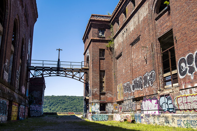
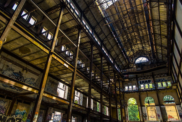
As mentioned yesterday, there are two buildings at the Glenwood Power Plant that we received access to. The first one, in yesterday’s post, was the generator building. The ones in today and tomorrow’s post are from the furnace and boiler building. This was a coal fired power plant, incidentally.
As a note, there were fishies swimming around in that puddle of water.
– photo by Mitch Waxman
There was a section of the roof which was unstable and we were gathered into a safe area beyond it for a few last shots of this section of the building.
It was time for the last leg of the excursion.

– photo by Mitch Waxman
Looking south out the boiler and furnace building’s window along the Hudson River, with Manhattan on the horizon. Just for a sense of place.
More tomorrow.
“follow” me on Twitter- @newtownpentacle
Buy a book!
“In the Shadows at Newtown Creek,” an 88 page softcover 8.5×11 magazine format photo book by Mitch Waxman, is now on sale at blurb.com for $30.
ten beings
Monday

– photo by Mitch Waxman
Pictured above is a former power plant, found alongside the Glenwood stop of the modern day Metro North rail service, in Yonkers – the first City that you’ll encounter when heading north out of NYC. The plant was built in 1907, when the NY Central Railroad was electrifying its system both in and into Manhattan. My pal Val had arranged for a small group of photographers to enjoy guided access to the site for a couple of hours. This building was abandoned in the early 1970’s, and has sat feral for the last fifty years or so.
This is an extremely well documented site, one which has been drawing in the “urban explorer” crowd for literally generations. Here’s a 2021 article from “Yonkers Times” discussing its current status, a Wikipedia page for “just the facts,” a 2014 NY Times report is here, and the views and plans of the current owners of the property can be examined at their website.

– photo by Mitch Waxman
As a note, my methodology for this sort of excursion is often thwarted as you just have to make the best of being on what’s essentially a walking tour. There were several other people shooting at the same time, which adds challenges as you need to dodge their POV’s, and the occasional accidental swing of a tripod leg or something.
People…
– photo by Mitch Waxman
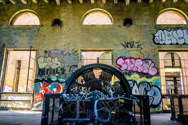
There are two main structures on the site, one is the building where the generator and battery rooms were housed, the other is where the coal furnaces and the boilers were located.
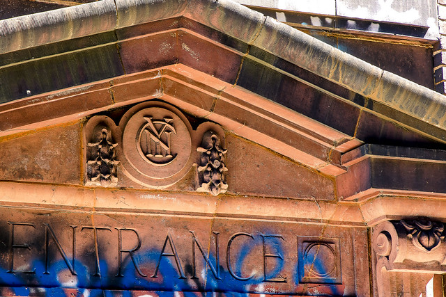
Our guide confirmed to me that the terra-cotta adorning the entryway into the generator building was – indeed – the product of the New York TerraCotta Works in Long Island City. Check out that old timey NY Central logo on the door lintel’s cornice piece.

– photo by Mitch Waxman
The generator room is pictured above, and as you’d imagine – those graffiti covered machines soon became a focus point for every lens in the room. I’ve looked around a bit since getting back from this trip, and it’s appears to me that every photographer with an interest in post industrial ruination has accomplished something very similar to the shot and composition I took above.
Methodology wise, I like to be able to learn a bit about a site. The photos in today and tomorrow’s posts are essentially scouting. I’d like to be in here at night with an extremely diffuse set of light sources. I’d also want to be inside this room in the extremely early morning AND at dusk. Dusk and heavy fog… hey now!
– photo by Mitch Waxman
Luckily, methodology wise, I’ve got a whole bag of tricks learned over the last fifteen years, along that shining ribbon of municipal neglect that provides a 3.8 miles long and currently undefended border for Brooklyn and Queens – the fabulous Newtown Creek.
My plan for these photos – which involved a one time opportunity at the subject – was to go “low and slow.” Unfortunately, neither time of day nor atmospheric humidity were on my side. An uncomfortably humid day would have created an absolutely visible miasma, but this was the day after a heat wave broke and it was unusually dry as a result.

– photo by Mitch Waxman
By “low and slow” I mean that the camera was on a tripod and seldom placed any higher than waste level. I affixed an ND filter to one of my zoom lenses, and either treated the image like a “night shot” with high ISO and longish shutter speed, or went full landscape mode with a 30 second long shot. I did some “exposure stacking” for a couple of these, most successfully in the shot directly above this one. That’s three exposures, each metered for and focused onto a different part of the image. In Photoshop, you can “blend” the three images together automatically.
Like a lot of things “digital,” once you conceptualize what’s actually happening when you tell an application to do something, the process can then be taken advantage of and guided. In the case of focus and or exposure stacking, it can get pretty exciting – results wise – if it’s subtle enough.
“follow” me on Twitter- @newtownpentacle
Buy a book!
“In the Shadows at Newtown Creek,” an 88 page softcover 8.5×11 magazine format photo book by Mitch Waxman, is now on sale at blurb.com for $30.
nerve specialist
Tuesday

– photo by Mitch Waxman
A humble narrator is taking this last week of summer off from narrating humbly, so single shots from past adventures are on offer. I’m out and about all week, if my plans work out, and will be back with fresh views of a City that doth not sleep after Labor Day.
That’s a United States Coast Guard ship pictured above, nosing into a pier on the Hudson River at some event I was attending a few years ago. A group of VIP’s were invited onboard.
Note: I’m writing this and several of the posts you’re going to see for the next week at the beginning of the week of Monday, August 31st. My plan is to continue doing my solo photo walks around LIC and the Newtown Creek in the dead of night as long as that’s feasible. If you continue to see regular updates here, that means everything is kosher as far as health and well being. If the blog stops updating, it means that things have gone badly for a humble narrator.
“follow” me on Twitter- @newtownpentacle
Buy a book!
“In the Shadows at Newtown Creek,” an 88 page softcover 8.5×11 magazine format photo book by Mitch Waxman, is now on sale at blurb.com for $30.
living thing
Happy Birthday Port Authority of New York and New Jersey.

– photo by Mitch Waxman
History boy wise, one makes it a point of keeping track of certain things, and especially so when it involves one of the organizations that make life possible within the megalopolis. Centered on the Statue of Liberty, if you were to draw a 25 mile long line on a map of New York Harbor, then rotate it into a circle that encompasses roughly 1,500 square miles… you’d begin to form an idea of the Port Authority of New York and New Jersey’s turf.
The first organization of its kind, and created on this day in 1921; Port Authority oversees tunnels, airports, cargo ports, sea ports, bridges, has an impressive real estate portfolio including the World Trade Center pictured above, operates train and bus stations, it’s own subway and freight rail lines, and operates a 1,700 member police organization which – in any other City – would be enormous.
As a note – PANYNJ is how the rest of this post is going to refer to the organization.

– photo by Mitch Waxman
That’s the PANYNJ’s George Washington Bridge pictured above.
Conflicts between the neighboring states of NY and NJ were a serious issue in the years leading up and including WW1, with squabbles over jurisdiction and competition for Federal funding getting in the way of “Progress” during the Progressive era. Modern day “progressives” don’t actually understand the term, I’m afraid. Back when it was coined, it was about streamlining and improving Government services, eliminating political corruption, and the scientific management of Government capital and resources to reduce wasted or duplicate effort. PANYNJ was formed specifically in the name of “Progress,” and to ensure economic growth in the bustling harbor cities of our archipelago.
Teddy Roosevelt, William Taft, and Woodrow Wilson were the national figures leading this “Progressive” movement which gave birth to the high priests of “Progress” a generation later – Robert Moses, Austin Tobin, the Rockefeller brothers; David and Nelson. All saw the so called “middle class” as the key to American prosperity and growth, and they spent their lives creating institutions and infrastructure to promulgate an expansion of this demographic.

– photo by Mitch Waxman
That’s PANYNJ’s Port Elizabeth Newark Global Marine Terminal pictured above, a small part of the third largest cargo port in the United States. After Wall Street, the actual wealth of NYC and NYS is entirely predicated on maritime trade. The Real Estate Industrial Complex of NYC is a comparative midget when you look at the economics of the Port of New York and New Jersey. Literally tens of billions of dollars of trade move through the facilities, with lots and lots of tax revenue extracted along the way.
The PANYNJ’s role in all this economic activity is to facilitate the physical plant of the port, ensure passage into the harbor via various maintenance functions like dredging and bridge maintenance and sometimes replacement, and to work with local shareholders. PANYNJ is authorized to issue bonds, borrow money, and act fairly independently of the political regimes in both states (although that last one is fairly debatable).

– photo by Mitch Waxman
That’s the Outerbridge Crossing on the Arthur Kill, named for Eugenius Outerbridge of the New York Port Authority (which predates PANYNJ).
Bridges and Hudson River crossings owned and operated by PANYNJ include Holland and Lincoln Tunnels, GW Bridge, Bayonne Bridge, Goethals Bridge, Outerbridge Crossing. They also run the PATH subway service, Port Authority and GW Bridge Bus Terminals. PANYNJ also owns the Expressrail network in New Jersey, a freight rail system.

– photo by Mitch Waxman
PANYNJ also operates NYC’s airports; including LaGuardia (pictured above), JFK, Newark, Atlantic City, Stewart International, and Teterboro.

– photo by Mitch Waxman
It’s been one hell of a 98 years for this organization, huh?
This history boy, for one, looks forward to their centennial.
“follow” me on Twitter- @newtownpentacle
Buy a book!
“In the Shadows at Newtown Creek,” an 88 page softcover 8.5×11 magazine format photo book by Mitch Waxman, is now on sale at blurb.com for $30.
malignly silent
Hudson Yards vs. Sunnyside Yards, what’s the difference?

– photo by Mitch Waxman
Last week I was invited to speak to a group of architecture students about the Sunnyside Yards. Part of the presentation involved discussion of the Hudson Yards project over in Manhattan, and how it can provide a model for development of the Sunnyside Yard. This is a false equivalency being offered by the powers that be, for a variety of reasons. The first and foremost thing to mention is that the Hudson Yards sit over an outcropping of Manhattan Schist and Gneiss, which provides for a stable underpinning for mega towers. Foundations are somewhat important, my engineer friends tell me, and the Sunnyside Yards sits on a compacted pile of clay and sand which until quite recently (1909) was a swamp.
Actual rock underpinnings on the northwestern side of a certain Long Island are absent west of Maspeth. If you find yourself in Maspeth, look west at what would appear to be a soup bowl, formed by elluvial deposits left behind by post glacial flooding. The piles which the mega developments of Long Island City sit upon are thus more numerous, and driven far deeper, than those in Manhattan which is technically a ridge of igneous rock. Soil conditions can be “engineered around” of course, since – theoretically speaking – if you possess enough money and technical acumen, you could build a ladder to the Moon if you wanted to. It’s just not practical to build a ladder to the moon, but since when does practical consideration get in the way of our Mayor’s political calculus.

– photo by Mitch Waxman
Hudson Yards was a challenge to the construction and engineering crowd, but a staightforward one inasmuch as the trackage leading out of Penn Station is arranged in parallels as you’ll notice in the shot above. What that means, from a decking perspective, is that you can set out the beams and columns needed to support the above ground structure at regular intervals and you’re essentially constructing a grandiose table or bench supported by multiple legs. The main problem they experienced was how to coordinate the movement of equipment in the cramped quarters of Manhattan.
Sunnyside Yards is defined by a convoluted series of intertwined rights of way which criss cross each other. Some of them, like the “balloon,” or turnaround, track travel over sweeping arches to switches which feed into either tunnels or holding tracks. You’ve even got the busiest railway switch in the entire country in there, the Harold Interlocking. Sunnyside Yards is complicated, and is already the eastern focal point of the largest capital project in the United States – the long delayed and vastly over budget East Side Access project which will allow Long Island Railroad access to Grand Central Terminal via LIC.
Why is it so over budget and so delayed, you ask? Because the MTA didn’t take into account the presence of buried waterways around and in the Sunnyside Yards (which was a big part of the Pennsyvania Railroad’s construction efforts a century ago), which any Queens historian can tell you are the buried remnants of Newtown Creek’s Dutch Kills tributary, and which once flowed to modern day Jackson Avenue and 29th street. Why do you think that section of LIC was called “Dutch Kills,” since it wasn’t named that for shits and giggles?

– photo by Mitch Waxman
The parallel nature of the tracks at Hudson Yards allowed for the usage of an esoteric bit of kit called a Beam Launcher, pictured above. The Beam Launcher facilitated the placement of the deck’s supporting beams onto concrete foundation from above, literally lowering them into place from above. The big yellow thing above is the Beam Launcher, which was about 3/4 the length of a Manhattan block. Steel beams were unloaded from trucks, which in some cases were loaded up from barges, brought to the job site, and then manipulated into position.
The beam launcher dealie is described in some detail, in this post from 2014.
“follow” me on Twitter- @newtownpentacle


