Archive for the ‘Long Island City’ Category
strange and brooding apprehensions
CREEK WEEK continues… for the first installment, from the mouth at the East River to the Pulaski Bridge, click here. For more on just the Pulaski Bridge, click here.

– photo by Mitch Waxman (from the Queens Museum of Art’s “Panorama of the City of New York”)
Moving a quarter mile eastward along the Queens bulkheads of the Newtown Creek from the Pulaski Bridge, the first tributary encountered by the intrepid urban explorer and photographer is a canalized horror called the Dutch Kills.
This branch of the Newtown Creek watershed is about an hour’s walk from Newtown Pentacle HQ, and its locale is visited or transited rather regularly by your humble narrator, as I perform the penitential exertions ordered by my physicians as the curative for certain extant health issues. All ‘effed up, my version of such wholesome activity requires the presence of the macabre, and some element of existential danger. Luckily- the Newtown Creek offers, to those who seek it, succor and salvation for a variety of desires.
Detailed postings, in and around the immediate neighborhood of the Dutch Kills waterway, include:
- Dutch Kills, or let the Photos do the Walking
- Long Island City Zen 2 -The Empty Corridor
- Weird Synchronicity
- After the Fire
- affordable housing development on Borden Avenue
- cry fowl, and let slip…
from wikipedia
Dutch Kills is a sub-division of the larger neighborhood of Long Island City in the New York City borough of Queens. It was a hamlet, named for its navigable tributary of Newtown Creek, that occupied what today is centrally Queensboro Plaza. Dutch Kills was an important road hub during the American Revolutionary War, and the site of a British Army garrison from 1776 to 1783. The area supported farms during the 19th Century, and finally consolidated in 1870 with the villages of Astoria, Ravenswood, Hunters Point, Middletown, Sunnyside and Bowery Bay to form Long Island City.

– photo by Mitch Waxman
Leaving the main course of the Newtown Creek, just .8 of a mile beyond its mouth, the first thing one encounters is a somewhat worse for wear railroad swing bridge- called the Long Island Railroad Bridge. Reports from “railfans” and “foamers” (and confirmed by the Coast Guard) state that the bridge hasn’t opened since 2002, which has orphaned the Dutch Kills from its parent waterway and cut the canal off from its intended usage. If my readings of old maps are correct (they often aren’t), these two tracks carry (or at least carried) rail traffic from either the Montauk Cutoff and Montauk Branch tracks, connecting the LIRR to the Sunnyside Yard and Wheelspur Yard with the tracks leading west to Hellsgate and east to Long Island. Notable former sights along this bank of the Newtown Creek would have been the City of New York’s Poultry Yard and the still extant Texas Oil Co.
For an extensive series of historical photos, discussion of the function and design of these tracks, and the industrial centers they once served- trainsarefun.com is the place to go. Special attention is called to this 1860 map of the area– which details the natural flow of the wetlands and shows the Dutch Kills as being a far larger body of water than it is today.
from Queens Borough, New York City, 1910-1920
During 1914 bulkhead lines were established by the United States Government for Dutch Kills Creek, a tributary of Newtown Creek, thus putting this stream under the jurisdiction of the War Department. The bulkhead lines as approved on October 29, 1914, give a width varying from 200 feet at its junction with Newtown Creek to 150 feet at the head of the stream, and include a large basin in the Degnon Terminal where car floats can be docked. The widths of the channel to be dredged under the appropriation of $510,000 mentioned previously, range from 160 feet at Newtown Creek to 75 feet at the turning basin. The Long Island Railroad plans to establish at this point a large wholesale public market, estimated to cost nearly $5,000,000.
Among the larger industrial plants in the Degnon Terminal served by this stream are : Loose Wiles Biscuit Company, American Ever Ready Works, White Motor Company, Sawyer Biscuit Company, Defender Manufacturing Company, Pittsburg Plate Glass Company, Marcus Ward, Brett Lithograph Company, Waldes, Inc., Norma Company of America, Manhattan-Rome Company, American Chicle Co. and The Palmolive Co.

– photo by Mitch Waxman
From Borden avenue, the second rail bridge is observed, which I believe to be the Montauk Cutoff track and a bascule type drawbridge. The canalized Dutch Kills, with its high bulkheads and rail connections, served as a water connection to NY Harbor for several heavy manufacturers in the area including F.A. Hunt, Holdtronics, New York Envelope, and American Chicle. The rail/dock complex, collectively, was known as the Degnon terminal. A short but sweet history of the Degnon Terminal can be accessed at members.trainweb.com. Michael Degnon was a master builder, one of the great men of the early 20th century in Queens, and is buried in Calvary Cemetery. Check out this nytimes.com article which discusses an expansion of his operations at the Dutch Kills in 1922 that brought floor space at his Degnon Terminal up to an astounding three million square feet.
from forgotten-ny.com
Michael Degnon was the contractor for the Steinway Tunnel, the first rail link to connect Manhattan and Queens, and also the contractor for the Sunnyside Yards. He decided to build his own railway, called Degnon Terminal, adjacent to the Sunnyside Yards and constructed large factories and warehouses complete with sidings facing the railroad tracks. This was attractive to his clients, since shipping goods via rail was now more accessible and less expensive for them. Some of the Terminal’s early clients were Sunshine Biscuit Company, Packard Automobile Company, American Ever Ready Company, and American Chicle Company. Of course, the rising cost of doing business in New York forced all of these companies to find other cities in which to manufacture. The sidings haven’t seen rail traffic since 1989, and the tracks are now either paved over or overgrown with weeds (some of which can be seen on FNY’s Disappearing Railroad Blues page). In its heyday, Degnon Terminal employed 16,000 workers.

– photo by Mitch Waxman
The currently “under construction” Borden Avenue Bridge allows vehicle and pedestrian traffic to cross the Dutch Kills. This is the point at which the water quality declines seriously, as the only fresh water entering its stagnant depths are combined sewer outputs (CSO’s) and runoff from the concretized industrial landscape surrounding it (which carry a stream of road salt, engine and exhaust residue, and whatever else might be on the road or sidewalk into the water every time it rains). The bridge recently celebrated its centennial, incidentally.
from the army corps of engineers, discussing precautions for the collecting, handling, and testing of Dutch Kills underwater sediments:
All individuals involved in handling contaminated sediment are required to use protective equipment and to submit to blood and urine tests. The protective equipment consists of:
from nyc.gov
As part of the construction of Borden Avenue in 1868, a wooden bridge was built over Dutch Kills. This bridge was later replaced by an iron swing bridge, which was removed in 1906. The current bridge was opened on March 25, 1908 at a cost of $157,606. The deck’s original design consisted of creosote-treated wood blocks, with two trolley tracks in the roadway. Character-defining features of this bridge include the stucco-clad operator’s house, four pairs of rails, and a rock-faced stone retaining wall. The gable-on-hip roof of the operator’s house retains the original clay tile at the upper part. Although alterations have been made, the bridge is a rare survivor of its type and retains sufficient period integrity to convey its historic design significance.
The Department of Transportation has identified a pocket of contaminated soil which has been classified as “contaminated non-hazardous”. As such, it poses no significant health risk to workers or the surrounding community. However, precautionary measures will be taken and every effort is being made to remove and dispose of the contamination quickly, yet safely, within all New York City and State guidelines. A Corrective Action Plan (CAP) for the removal and disposal of the contamination has been submitted to the NYS Department of Environmental Conservation (NYSDEC) for review and approval.

– photo by Mitch Waxman
Sewer construction projects along Hunters Point Avenue revealed that the swampy nature of western Queens is unchanged. These ground waters, as you might observe by the chalk markings on the pilings, would be some 13 feet beneath the streets. The vertical clearance of the nearby Hunters Point Avenue Bridge (and street grade) is approximately 15 feet over the water, so this would make sense.
Never forget, lords and ladies, that this Long Island City of ours is a swamp which was “reclaimed” by industrial means just within the last 150 years. The “ground” in most of the area is actually a sort of pier or dock, with timber pilings supporting cement clad fill. Just two stories down are the waters of the Newtown Creek and it’s tributaries, and this sort of subterrene terraforming is typical for most of the spongy land directly surrounding the Newtown Creek.
Who can guess, what poisons there are, laying in the mud waiting to hatch out?
from hydroqaul.com
Like a number of other local tributaries to New York Harbor, Newtown Creek is now simply a peripheral canal system fed by tides, CSO and stormwater discharges. None of its original freshwater creeks and extensive wetlands exist anymore, the whole area having been transformed into a series of canals by channelization, land reclamation (filling) and bulkheading. Biological abundance and diversity is impaired by reductions in the amount and variety of physical habitat, and by a vulnerability of the remaining habitat to retention and accumulation of pollutants. Although no scientific studies have been identified prior to 2001, it can be expected that biota of Newtown Creek reflect similar conditions in other highly impacted waterbodies around the harbor. Thus, a fouling community composed of epibenthic invertebrates such as barnacles and sea squirts should be present on pilings and bulkheads; a fairly homogenous community of benthic invertebrates dominated by tolerant forms of polychaete worms should be found in the sediments, and a typical assemblage of regionally indigenous fish such as striped bass, winter flounder, bay anchovy, Atlantic menhaden, snapper bluefish, sea robin and tautog may come and go as water levels and quality permit.

– photo by Mitch Waxman
The Hunter’s Point Avenue Bridge offers spectacular views of the Long Island Expressway with Brooklyn beyond, and from its walkway; the bulkheads marking the end of the Dutch Kills are visible. This is a dead zone, check out riverkeeper.org’s analysis of the waters here over a multiple year period. The foulness of these waters are part of the historical record, which an a New York Times article from March of 1871 proves, and the evidences of one’s own senses suggest.
from nyc.gov
The Hunters Point Bridge over Dutch Kills is situated between 27th Street and 30th Street in the Long Island City section of Queens, and is four blocks upstream of the Borden Avenue Bridge. It is a bascule bridge with a span of 21.8m. The general appearance of the bridge has been significantly changed since it was first opened in 1910. The bridge provides a channel with a horizontal clearance of 18.3m and a vertical clearance, in the closed position, of 2.4m at MHW and 4.0m at MLW. The bridge structure carries a two-lane, two-way vehicular roadway with sidewalks on either side. The roadway width is 11.0m, while the sidewalks are 1.8m wide. The width of the approach roadways vary from the width of the bridge roadway. The west approach and east approach roadways are 13.4m and 9.1m, respectively.
The first bridge at this site, a wooden structure, was replaced by an iron bridge in 1874. That bridge was permanently closed in 1907 due to movement of the west abutment, which prevented the draw from closing. It was replaced in 1910 by a double-leaf bascule bridge, designed by the Scherzer Rolling Lift Bridge Company. The bridge was rebuilt in the early 1980’s as a single-leaf bascule, incorporating the foundations of the previous bridge.

– photo by Mitch Waxman
At the end of the Dutch Kills, one finds a concrete company, and the former Degnon Terminal home of Sunshine Biscuits, which today serves as the “C’ building of the LaGuardia Community College campus (found between 29th and 30th streets and between 47th avenue and the intersection of Skillman and Thompson avenues). Additionally, the greater astoria historical society has posted a photo at smugmug that shows the rest of the scene in the shot above dating from 1966.
speaking of gahs, they have a short history of Sunshine Biscuit’s “thousand window factory” which can be accessed by clicking here

– photo by Mitch Waxman
A quick glance down at the banks of Dutch Kills reveal the true nature of things here, it is not uncommon to half glance at dead things floating by, suspended by their internal gases. At high tide on the East River, aquatic life often finds its way into the Newtown Creek and become entrapped in the oxygen deprived water. This provides ample food for thriving colonies of carnivorous worms and shore line scavengers- mainly river rats, the cats that prey on them, and various birds.
Few if any dogs have I observed down here, even where you’d expect them to be. Guard dogs are unemployed around these parts, and I’ve never seen a feral dog roaming around in all the time I spend scuttling around the area- but that’s probably because of all the trucks. I do know a fat old dog who’s chained to a fish butcher on 51st avenue, but she’s mainly interested in her sunny sidewalk and sleeping.
from nytimes.com
Hunters Point South, for its part, will have 5,000 homes built on 30 acres on the edge of the East River, near Newtown Creek. Three thousand of the homes will be set aside for families whose annual income totals $126,000 or less, with 800 of them destined specifically to families who earn less than $61,400 a year. There will also be 300 units built for low-income senior citizens and at least 225 units devoted to a middle-class homeownership program.
“We’re creating a model,” said Councilman Eric N. Gioia, whose district includes the area where the project will be built. “We’re creating housing where all New Yorkers can live together, in the same neighborhood.”

– photo by Mitch Waxman
At the end of Dutch Kills, near 47th avenue, illegal dumping seems to be a community passion. There is even a rusted out and derelict barge which seems to finally be sinking. As always, admonishment and advice for the urban explorer to ignore the temptation to climb out and take a look applies. The wet filth that lines the shore here stinks of sulphur compounds, and the smell of a sick aquarium permeates the breeze. This is also a HAZMAT zone, and nautical charts reveal that the water depth here is 13-15 feet, roughly a third deeper than it is in the channel. Don’t screw around back here, lords and ladies, you can get seriously hurt.
from nyc.gov, on the waterfront revitalization section of the Hunters Point South development plan
Policy 6.2: Direct public funding for flood prevention or erosion control measures to those locations where the investment will yield significant public benefit.
The proposed actions do not include public structural flood and erosion control projects. The central and eastern portion of Site A and much of Site B are within the 100-year floodplain.
The New York City Building Code (Title 27, Subchapter 4, Article 10) requires that residential buildings have a finished floor elevation (FFE) at or above the 100-year floodplain, while the Federal Emergency Management Agency (FEMA) requires the FFE to be one foot above the 100-year floodplain. In accordance with these regulations and as stated above, clean fill would be used to raise the development area, including the areas for new streets and buildings, as well as portions of the project sites designated for the waterfront park or other open space areas that would not be covered by impervious surface or structures. Raising the elevation of the project sites above the 100-year flood elevation would ensure protection of public health and safety, the new buildings and open space areas, public investment of city infrastructure, and enhancement of natural habitats. The proposed actions are consistent with this policy.

– photo by Mitch Waxman
On the Brooklyn side of the Newtown Creek is another tributary called Whale Creek (don’t worry, we’ll be going there soon enough), alongside which the magnificent Newtown Creek Wastewater Treatment Plant hums and belches methane in storied Greenpoint. This spot on 29th street, at the end of the Dutch Kills, is just under a half mile from the main channel.
A Newtown Pentacle posting from October of 2009 explored this Temple of Cloacina, which is a 24 hours a day municipal workhorse. The plant processes a significant percentage of the 1.1 billion gallons of sewage New York produces every day, delivering it in a milled and concentrated form to a pumping tank and dock in Greenpoint directly across the Creek from the forthcoming Hunters Point South development which is just starting on the Queens shoreline. In still another posting, we followed some sludge boats- the M/V Newtown Creek, North River, and the Red Hook, as they traveled past Hallet’s Cove and Astoria up the East River.
from nyc.gov
Dewatering reduces the liquid volume of sludge by about 90%. New York City operates dewatering facilities at eight of its 14 treatment plants. At these facilities, digested sludge is sent through large centrifuges that operate like the spin cycle of a washing machine. The force from the very fast spinning of the centrifuges separates most of the water from the solids in the sludge, creating a substance knows as biosolids. The water drawn from the spinning process is then returned to the head of the plant for reprocessing. Adding a substance called organic polymer improves the consistency of the “cake”, resulting in a firmer, more manageable product. The biosolids cake is approximately 25 to 27 percent solid material.

Hunters Point to Dutch Kills with Whale Creek on the left – photo by Mitch Waxman (from the Queens Museum of Art’s “Panorama of the City of New York”)
Creek Week continues… at this, your Newtown Pentacle. Prepare to penetrate into the darkness of the tomb legions, lords and ladies… as we move eastward.
horrible and unearthly ululations…

– photo by Mitch Waxman (from the Queens Museum of Art’s “Panorama of the City of New York”)
Loathsomeness awaits, in the deep.
At the end of the Pleistocene, when the ice of the Wisconsinan glaciation was at last defeated by ocean and sun, the rubble which spilled from its ruptured facings piled up to form the terminal moraine of a cyclopean coastal sandbar, as well as many smaller islands. The torrents of flowing mud and water – acting in the manner of icy Lahars– interacted with this loose fill of titan boulders and frosty soil, amalgamating around stoney knobs of bedrock. These rough bits of rock, exposed by the motive traction exacted by ten thousand years of mile high ice, formed and agglutinated into an archipelago and estuary familiar to modernity as New York Harbor.
At the western tip of the sandbar, which european cartography called Long Island, an arabesque web of waterways was carved out of this turbulent tidal and river environment.
Welcome to the Newtown Creek.
from wikipedia
The Wisconsin Glacial Episode was the last major advance of continental glaciers in the North American Laurentide ice sheet. This glaciation is made of three glacial maxima (sometimes mistakenly called ice ages) separated by interglacial warm periods (such as the one we are living in). These glacial maxima are called, from oldest to youngest, Tahoe, Tenaya and Tioga. The Tahoe reached its maximum extent perhaps about 70,000 years ago, perhaps as a byproduct of the Toba super eruption. Little is known about the Tenaya. The Tioga was the least severe and last of the Wisconsin Episode. It began about 30,000 years ago, reached its greatest advance 21,000 years ago, and ended about 10,000 years ago. At the height of glaciation the Bering land bridge permitted migration of mammals such as humans to North America from Siberia.
It radically altered the geography of North America north of the Ohio River. At the height of the Wisconsin Episode glaciation, ice covered most of Canada, the Upper Midwest, and New England, as well as parts of Montana and Washington. On Kelleys Island in Lake Erie or in New York’s Central Park, the grooves left by these glaciers can be easily observed. In southwestern Saskatchewan and southeastern Alberta a suture zone between the Laurentide and Cordilleran ice sheets formed the Cypress Hills, which is the northernmost point in North America that remained south of the continental ice sheets.
The Great Lakes are the result of glacial scour and pooling of meltwater at the rim of the receding ice. When the enormous mass of the continental ice sheet retreated, the Great Lakes began gradually moving south due to isostatic rebound of the north shore. Niagara Falls is also a product of the glaciation, as is the course of the Ohio River, which largely supplanted the prior Teays River.
With the assistance of several very large glacial lakes, it carved the gorge now known as the Upper Mississippi River, filling into the Driftless Area and probably creating an annual ice-dam-burst.
In its retreat, the Wisconsin Episode glaciation left terminal moraines that form Long Island, Block Island, Cape Cod, Nomans Land, Marthas Vineyard, and Nantucket, and the Oak Ridges Moraine in south central Ontario, Canada. In Wisconsin itself, it left the Kettle Moraine. The drumlins and eskers formed at its melting edge are landmarks of the Lower Connecticut River Valley.

– photo by Mitch Waxman (from the Queens Museum of Art’s “Panorama of the City of New York”)
3.8 miles long, its mouth is directly opposite the Bellevue Psychiatric Hospital in Manhattan, and defines the currently undefended border between North Brooklyn and Western Queens. Estimates state that some 14 million gallons of combined sewage, storm runoff, and industrial waste provide the only flow of water into the Creek. It’s waters are opaque, and in the height of summer turn an unnatural shade of green.
The soft bottom of the waterway is 15-20 feet below the surface of the water, and the hard bottom is occluded by a gelatinous sediment known as “Black Mayonnaise”. Composed of petroleum residues, coal tar, PCB’s, and human excrement- it lies 15 feet thick on the bed. The oxygen content of the water drops precipitously as soon as one leaves the East River. The first of the drawbridges which cross it- known as the Pulaski Bridge, is the borderline beyond which immersion in this water is worthy of full HAZMAT gear and first responders institute biological decontamination procedures for anyone who finds themselves in it.
As I’ve mentioned in the past… the chemicals Putrescine (an organic chemical compound NH2(CH2)4NH2 (1,4-diaminobutane or butanediamine) and Cadaverine (a toxic diamine with the formula NH2(CH2)5NH2) which are produced by the rotting and putrefaction of animal flesh are abundantly found in the Newtown Creek under industrial aliases like Acrylonitrile and are prominent members on the EPA’s list of Volatile Organic Compounds– or VOC’s..
Who can guess, what it is, that may be buried down there?
from brookhaven national laboratories
Sediments from the New York/New Jersey Harborareas are dredged routinely to maintain navigable water depths for shipping channels and berthing areas to facilitate commerce and safe navigation. Historically, the dredged materials was disposed in the ocean. However, ocean disposal has been restricted due to greater regulatory restrictions on contaminant concentrations in the dredged sediments. The dredged sediments typically contain elevated levels of metals, polynuclear aromatichydrocarbons (PAHs) (tars, oils, fuels) polychlorinated biphenyls (PCBs), chlorinated pesticides and herbicides, dioxins (PCDDs), andfurans (PCDFs) as shown in Table 1-1[l] for Newtown Creek. Table 1-1, included at the end of this section, lists both the range previously available from the Request for Proposal and the average of six samples available to date for the treatability studies.The actual sediment used for the test was a black mayonnaise-like paste that contained few particles (or 0.2% on dry basis) greater than 2 mm, and exhibited an oily, foul odor.
BNL and other governmental federal and state agencies are in the process of developing risk-based and/or specific clean-up standards for the various locations where the treated sediment products are to be used. These standards are likely to be related to the soil clean-up criteria used based on direct soil contact (residential and non-residential) and/or impact to groundwater. For example, Appendix A contains the current soil clean-up criteria used by the State of New Jersey and the Maximum Concentration of Contaminants for the Toxicity Characteristic. Based on the sediment from Newtown Creek and the soil clean-up criteria for direct soil contact, some contaminants already meet the clean-up criteria while some need up to one or two orders-of-magnitude removal. The TCLP values for the Newtown Creek sediment are below the maximum toxicity characteristic value.

– photo by Mitch Waxman
There are 5 major vehicular traffic bridges which hurtle over the Newtown Creek, 3 of which are drawbridges and one is a non functioning swing bridge. It’s tributary branches are also crossed by a variety of other spans, from the high flying Queens Midtown Expressway section of the Long Island Expressway and the grade level Hunter’s Point Avenue drawbridge to the Borden Avenue retractile bridge over the Dutch Kills. Additionally, atavist rail bridges and trackbeds stretch from no longer existing car docks at Hunters Point to the massive rail terminals and switchings in Maspeth and lead to points further East. Municipal neglect has rendered many of these bridges dangerously decayed, non functional, or dangerous to operate. Once, this was the busiest industrial waterway in North America.
A spate of emergency repairs and reconstructions was conducted in the 1980’s and 90’s to shore up these crossings. For instance, the 1910 Hunter’s Point Avenue Bridge, originally a double leaf bascule design like the Pulaski, was replaced by a single leaf design and in 1987- the 1929 Greenpoint Avenue Bridge was rebuilt- and the 1959 Pulaski was rebuilt in the early 1990’s.
from nyc.gov
The Pulaski Bridge, which carries six lanes of traffic and a pedestrian sidewalk over Newton Creek and the Long Island Expressway, is orientated north-south and connects Greenpoint in Brooklyn to Long Island City in Queens. McGuinness Boulevard approaches the bridge from the south and Eleventh Street from the north. The Pulaski Bridge is a 54m double leaf, trunnion type bascule bridge. It has two 10.5m roadways divided by a concrete median barrier. It also carries a 2.7m pedestrian sidewalk. The bridge provides a channel with a horizontal clearance of 45.7m and a vertical clearance of 11.9m in the closed position at MHW and 13m MLW.

– photo by Mitch Waxman
There is a “colour” observed around the Newtown Creek. An iridescent sheen which seems to have been drawn from a palette not of this earth, rather it is best described as looking like some “Colour out of space“. Observable on every oil soaked cobblestone which pushes up through the asphalt, and pulsing through thorny vines which line the rotting bulkheads and sway against the putrid breeze, this colour is only the visible manifestation of a detestable lament which has infected the land and percolates in the swampy underworld hidden by piling and cement some 10-20 feet beneath the so called land. Wild catalogs of chemical compounds congeal in unknowable combinations, pooling in vast subterrene chambers and mixing with an underground water table that feed the sickly trees lining area streets.
Fish and invertebrates harvested from the Newtown Creek display open sores, unexplained tumors, and queerly mutated organs. Weird eyeless things can be seen wriggling in the filth, at low tide.
The surface of the water has tested positive for a variety of bacterial specie including Gonorrhea, Typhus, and Cholera.
from epa.gov
“Newtown Creek is one of the most grossly-contaminated waterways in the country,” said Acting Regional Administrator George Pavlou. “By listing the creek, EPA can focus on doing the extensive sampling needed to figure out the best way to address the contamination and see the work through.”
EPA responded to requests by members of Congress to evaluate specific sites along the creek by publishing a September 2007 report that contained a review of past work and recommendations regarding future work at Newtown Creek. The state of New York referred the site to EPA due to the complex nature of the contamination along the creek.
Newtown Creek is part of the core area of the New York-New Jersey Harbor Estuary, which has been designated by EPA as an “estuary of national significance.” Despite the ongoing pollution problems, some residents currently use the creek for recreational purposes such as kayaking, while others catch fish for consumption out of it. Various sediment and surface water samples have been taken along the creek and reveal the presence of pesticides, metals, PCBs, and volatile organic compounds (VOCs), which are potentially harmful contaminants that can easily evaporate into the air.
In the mid -1800s, the area adjacent to the 3.8-mile Newtown Creek was one of the busiest hubs of industrial activity in New York City. More than 50 industrial facilities were located along its banks, including oil refineries, petrochemical plants, fertilizer and glue factories, sawmills, and lumber and coal yards. The creek was crowded with commercial vessels, including large boats bringing in raw materials and fuel and taking out oil, chemicals and metals. In addition to the industrial pollution that resulted from all of this activity, the city began dumping raw sewage directly into the water in 1856. During World War II, the creek was one of the busiest ports in the nation. Some factories and facilities still operate along it, and various adjacent contaminated sites have contributed to its contamination. Today, as a result of its industrial history, including countless spills, Newtown Creek is badly polluted.

– photo by Mitch Waxman
The northern bank of the Newtown Creek forms the border of Long Island City, and swirls through Laurel Hill (or Blissville), Sunnyside, Ridgewood, and Maspeth in Queens. The southern bank in Brooklyn is dominated by the ancient cities of Greenpoint, Bushwick, and Williamsburg.
from wikipedia
Greenpoint was originally inhabited by Keskachauge (Keshaechqueren) Indians, a sub-tribe of the Lenape. Contemporary accounts describe it as remarkably verdant and beautiful, with Jack pine and oak forest, meadows, fresh water creeks and briny marshes. Water fowl and fish were abundant. The name originally referred to a small bluff of land jutting into the East River at what is now the westernmost end of Freeman Street, but eventually came to describe the whole peninsula.
In 1638 the Dutch West India Company negotiated the right to settle Brooklyn from the Lenape. The first recorded European settler of what is now Greenpoint was Dirck Volckertsen (Dutchified from Holgerssøn), a Norwegian immigrant who in 1645 built a one-and-a-half story farmhouse there with the help of two Dutch carpenters. It was in the contemporary Dutch style just west of what is now the intersection of Calyer St. and Franklin Street. There he planted orchards and raised crops, sheep and cattle. He was called Dirck de Noorman by the Dutch colonists of the region, Noorman being the Dutch word for “Norseman” or “Northman.”
Kneeling upright

– photo by Mitch Waxman
The local supermarket, a Pathmark on Northern Blvd., has installed a device on its shopping carts that lock the wheels when you try to roll them off the property line. A buried wire, perhaps, or some sort of radio signal keeps the carts from distributing themselves around the neighborhood like the Home Depot and Stop n’ Shop carts that can found in basements and garages across the Newtown Pentacle. Once, this was the preferred cargo carrier for New York’s unfortunates, an uncovered wagon for the concrete prairies.
from wikipedia
Shopping cart theft can be a costly problem with stores that use them. Often the carts end up in apartment complexes, low-income housing, bus stops or locations where the person doing the shopping is unlikely to own a car. The carts, which cost between $75 and $150 each, have been used for such purposes as barbecue pits, go-carts, laundry trolleys and even shelters, or they are simply abandoned. Because such losses can be substantial (up to $800 million globally lost every year), stores have resorted to various systems to prevent theft. Stores may use one or more of these systems (i.e., cart retrieval and electronic).
Cart retrieval service
Some stores utilize a cart retrieval service, which collects carts found off the store’s premises and returns them to the store for a fee. The drawbacks of this measure include that it is reactive instead of proactive (i.e., it can only be used once a cart has been taken from the premises), can become costly, and does nothing to deter hoarders. Some retrieval services have also been caught taking carts from the store’s parking lot and turning them in as stray carts.
Electronic
Electronic systems are being increasingly used by stores because of their successful deterrence. In principle, the system is similar to electric fences that give dogs’ necks a yank when they cross an underground boundary. Each shopping cart is fitted with an electronic locking wheel, or ‘boot’. A transmitter with a thin wire is placed around the perimeter of the parking lot. The boot locks when the cart leaves the designated area. Store personnel must then deactivate the lock with a hand-held remote to return the cart to stock. Often a line is painted in front of the broadcast range to warn customers that their cart will stop when rolled past the line.

– photo by Mitch Waxman
The cheap wire shopping carts offered to perform the curb to house function today just can’t compare. The bottle and can collectors favor this sort of model, and an iteration of it is found in my own kitchen. It’s not sturdy, quite unstable, and has an incontrovertibly high center of gravity making it prone to unexpected tipping. A sudden abundance of laundry here at Pentacle HQ was instrumental in discovering its load capacity was a mere 80 pounds (don’t ask) which causes the wheels to snap off. A sturdy supermarket style cart carries an unknown, but substantially higher weight.
from nyc.gov
To ready your metal, glass and plastic containers for recycling, rinse them clean and place them in a clear bag or blue-labeled container; caps and lids should be removed. You should place paper recycling in a separate clear bag or green-labeled container and tie flattened corrugated cardboard with strong twine.
Collect glass, plastic or aluminum beverage containers with a 5-cent deposit, such as those for beer, soda and other carbonated drinks, and take them to a local grocery, deli or other store for recycling. (You can also put your redeemable cans and bottles out with your other recyclables where needy individuals may find them and turn them in for the nickel deposit.)
If you live in a building that does not recycle, contact your building manager or superintendent to set up a recycling system for tenants. You can report recycling violations anonymously online or by calling 311.

– photo by Mitch Waxman
To a veteran of the 1980’s and early 90’s iteration of New York City- when 42nd street at Times Square was called “dadeuce”- a time when endemic homeless populations ruled the streets, it is disturbing to see their population swelling again. The local Croats and Serbs refer to the village madmen as “sin eaters”, and the more august members of the community have other colorful terms to describe them. New immigrants are typically less than charitable toward such individuals, but to be fair- their perspective is that of having showed up in this country with just a suitcase and then building a life for themselves within just a few years. It is inconceivable to these new citizens to see an American who would live in such a state, when the solution to all their problems is “work”, an opportunity not available or perhaps denied in their countries of origin.
from wikipedia
The term sin-eater refers to a person who, through ritual means, would take on by means of food and drink the sins of a deceased person, thus absolving his or her soul and allowing that person to rest in peace. In the study of folklore sin-eating is considered a form of religious magic.
This ritual is said to have been practised in parts of England and Scotland, and allegedly survived until modern times in Wales. Traditionally, it is performed by a beggar and certain villages maintained their own sin-eaters. They would be brought to the dying person’s bedside, where a relative would place a crust of bread on the breast of the dying and pass a bowl of ale to him over the corpse. After praying or reciting the ritual, he would then drink and remove the bread from the breast and eat it, the act of which would remove the sin from the dying person and take it into himself.

– photo by Mitch Waxman
The fellow pictured above, a “regular” along Northern Blvd., is actually quite mad. I’ve spoken to him- he calls me “Mr. Camera Lens Man”. Back in my merciless youth, a time when I scorned weakness and foreswore empathy, individuals who exhibited similar appearance and behavior were christened Shipwreck Victims. They appear to have been deposited on the sidewalk by some titanic wave, mournfully lost in a foreign city. For many years, I lived on the corner of 100th and Broadway in Manhattan, and the neighborhood had a colorful cast of mendicants.
from nypirg.org
- In its 1998 survey of 30 cities, the U.S. Conference of Mayors found that the homeless population was 49% African-American, 32% Caucasian, 12% Hispanic, 4% Native American, and 3% Asian (U.S. Conference of Mayors, 1998).
- 46% of cities surveyed by the U.S. Conference of Mayors identified domestic violence as a primary cause of homelessness (U.S. Conference of Mayors, 1998).
- Research indicates that 40% of homeless men have served in the armed forces, as compared to 34% of the general adult male population (Rosenheck, Robert, Homeless Veterans, in Homelessness in America, 1996).
- Approximately 20-25% of the single adult homeless population suffers from some form of severe and persistent mental illness (Koegel, Paul, The Causes of Homelessness, Homelessness in America, 1996, Oryx Press.). According to the Federal Task Force on Homelessness and Severe Mental Illness, only 5-7% of homeless persons with mental illness require institutionalization; most can live in the community with the appropriate supportive housing options (Federal Task Force on Homelessness and Severe Mental Illness, 1992).

– photo by Mitch Waxman
Larry “the Wild Man” Hogue haunted 96th street, terrifying residents and attacking random passerby- the Police had him on a revolving door version of jail. This was, of course, before Rudy Giuliani defined the Bill of Rights as containing no provision guaranteeing the right to sleep in the street.
There was Raggedy Andy, who suffered from AIDS, and would tell you as a matter of fact that he didn’t want handout money for food, he was going to use it to buy crack. Andy was meant to take the homeless bus every night to a medical dorm at Riker’s Island, to get his antibiotics for the various infections afflicting his skeletal frame, but the trip from the upper west side would deliver him there at 2:30 AM and wake up was at 6 so he only went 3-4 times a week (or so he said). The original “ship wreck victim”, along with “the suffering man” and my 80 year old friend Bent Willette (who was on heroin since the 1930’s- an astounding run- in her 70’s she started doing crack to “stay alert”) worked the 96th street and Broadway subway stop. On the east side, my pal Ricky lived behind the basketball game in a Third Avenue Irish bar, working for drinks as a bar back and signing his social security check over to the owner as rent for the pile of rags he slept on. An NYU student dormitory is there now.
from the nydailynews.com site, dated May 30, 2009
Larry Hogue, a drug-addicted wacko who terrorized Upper West Siders in the 1990s, strolled away from the Creedmoor Psychiatric Center in Queens on Thursday.
The notorious hell-raiser was arrested “without incident” in his old stomping grounds Saturday morning after being spotted on 96th St. between Broadway and Amsterdam, cops said.

– photo by Mitch Waxman
In the angle between Astoria and Woodside, all along the LIRR tracks- I observe long established homeless camps. There’s a well developed one on Shore Road by Astoria Park at the river bank, down at the bottom of the wall. LIC’s empty corridor, and all along Borden Avenue as it tracks toward the hallowed altitude of Calvary sustains a large population of tyvek tents. A few weeks ago I showed you the Black Crow’s nest at Dutch Kill’s Borden Avenue Bridge, and a while back ran a few shots of the troll who lives up the block (he does live under a bridge).
Don’t get me wrong, I’m not making fun of these people, or making light of their desperate plight or calling for the massive powers of the government to do anything at all. Most of the homeless guys (especially guys) that I know are square pegs, or addicted to something, or stark raving mad. This is one of those societal “things” that cannot be fixed, and its a problem as old as civilization. See, the problem is that this population resists being “civilized” (read civilized as a verb) which they perceive as living in a prison. As always, no moral overlays- not good nor bad- just “is”.
Build all the shelters you want to, but all that Raggedy Andy wanted was to just get high and be left alone, especially when it was snowing.
highly visible
Broadway near Steinway Street – photo by Mitch Waxman
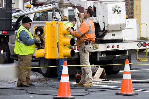
As your humble narrator scuttles from place to place, turning over rocks to see what blind albino abnormalities might lurk beneath, a significant amount of road construction is encountered. New York is always in a state of near collapse and an army of municipal and contractor labor is kept busy filling in the cracks. Conflicted over sneaking pictures of these folks, I nevertheless find them fascinating, for the high visibility colors they wear excite the eye.
from workzonesafety.org
Title: ANSI/ISEA 107-2004: Revised American National Standard for High-Visibility Safety Apparel and HeadwearAbstract: This standard provides a uniform, authoritative guide for the design, performance specifications, and use of high-visibility and reflective apparel including vests, jackets, bib/jumpsuit coveralls, trousers and harnesses. Garments that meet this standard can be worn 24 hours a day to provide users with a high level of conspicuity through the use of combined fluorescent and retroreflective materials. The revised version of the standard expands the product coverage to include high-visibility headwear. It also contains additional testing procedures for knitted fabrics used as background material, and eliminates tests from the previous edition that added no value. Publisher: International Safety Equipment Association

Third Avenue Manhattan – photo by Mitch Waxman
If it won’t blind or distract the crews, don’t forget that this is heavy industry and quite dangerous work, try turning on the camera flash when photographing them. The reflective fabrics, technically retroreflective fabrics (which function like a Cat’s eyeshine), will blaze up and be the brightest point in the photo. New York City street signs also function in a similar fashion, and even the weakest flash will light them up from blocks away. Try it, especially on a dark and stormy day, the effects are somewhat unpredictable and often produce a prismatic and surreal photo.
from simplifiedsafety.org
Class 1: needs to be conspicuous and use retroreflective materials not less than 25mm in width.
- Used when workers are well separated from traffic
- Vehicle speeds of less than 25 mph
- Parking attendants
- Shopping cart retrievers
- Warehouse workers
- Roadside/sidewalk maintenance workers
- Delivery vehicle drivers
Class 2: maintains superior visibility and are more conspicuous than the Class 1 garments. Minimum width of retroreflective material used on these is not less than 35mm.
- Used when workers are on or near roadways
- Vehicle speeds of 25 to 50 mph
- Roadway construction workers
- Utility workers
- Survey crews
- Law enforcement personnel
- Crossing guards
- High-volume parking lot or toll-gate attendants
- Airport baggage handlers and ground crews
- Railway workers
- Emergency response personnel
- Accident site investigators
Class 3: has greatest visibility. Maintains more retroreflective material than Class 2 and must have sleeves with retroreflective material between the shoulders and elbows. Not less than 50mm wide of retroreflective material.
- Used for workers in high risk situations
- Allows them to be seen from a minimum distance of 1,280 ft.
- Vehicle speeds of greater than 50 mph
- Roadway construction workers
- Utility workers
- Survey crews
- Emergency response personnel

31st street, Astoria – photo by Mitch Waxman
All of the municipal and construction rules are meant to conform to the national OSHA specifications, but individual city organizations have their own wrinkle on safety gear. MTA workers, for instance, are often observed wearing goggles and ear protection as they work. No doubt, this is due to individual union agreements and task specific requirements.
from nysdot.gov
All DOT employees, contractor employees and visitors must wear protective helmets and high visibility construction apparel while working within a highway right of way or contract limits. Flaggers must wear high visibility traffic control apparel when directing or spotting traffic. High-visibility apparel is not required for employees and visitors when they are within a completely enclosed cab constructed of steel frame and glass, or inside a motor vehicle.

37th avenue, Dutch Kills – photo by Mitch Waxman
NYFD, of course, has the most stringent series of rules for its crews. In the shot above, a 5 alarm fire at an industrial warehouse was belching black smoke into the street, but the firefighters are clearly identifiable through the murk- due to camera flash. Be careful around NYFD however, as they’re kind of busy people, and you don’t want to distract them. Also, should there be any piezoelectric activated equipment in use- DO NOT use your flash for fear of activating something.
from fasny.com
Back in November of 2008, there was a lot of confusion about the use of high-visibility vests at roadway incidents due to a new Federal Highway Administration (FHWA) Rule. The new regulation, Rule 634, stated that “All workers within the right-of-way of a Federal-aid highway who are exposed either to traffic (vehicles using the highway for purposes of travel) or to construction equipment within the work area shall wear high-visibility safety apparel.”
That regulation created a dilemma for fire departments who were truly interested in protecting their personnel. The training classes and material used by the Emergency Responder Safety Institute (ERSI) for years has suggested the use of high-visibility garments for public safety personnel when working around traffic. NFPA 1500, the Firefighter Health and Safety Standard has included a requirement for firefighters to wear safety vests at traffic incidents in the last two most recent editions. NIOSH Line of Duty Death Investigations have also included recommendations for responders to wear highly visible flagger vests when exposed to moving traffic. In the fire service community it was generally understood that the vests were not appropriate personal protective equipment (PPE) for personnel who were actively engaged in firefighting operations because those garments are not designed for exposure to fire, heat flame or hazardous materials. Rule 634, as originally published however did not outline any exemptions for firefighters engaged in direct firefighting operations and that created the dilemma.

Bridge Plaza North, Queens Plaza – photo by Mitch Waxman
The shot above is fascinating to me, for reasons that have little to do with the safety equipment exhibited. The trench that this trio is working in is down by Queens Plaza, and the cutaway shows a historical record. Notice the top layer of asphalt, then two distinct layers of cobblestones, then dirt and rock fill. Asphalt- modern, cobbles 1- the construction of the Queensboro bridge and associated roadways, cobbles 2- the pre bridge street, dirt and fill- that’s a 19th century, civil war era street. I’d love to have an archaeologist sift through this trench, but there’s nothing of historic importance in Queens… according to the City.
Note- the Charles Rudebaker wiki quote below… I’m a little squirrely on this particular wikipedia entry. The only info I could find on Rudebaker, a New Yorker who supposedly invented the Traffic Cone, parroted this exact wording all across the net. Take it with a grain of salt, until I can find out more. It very well might be a “false meme” which is a sort of “Lulz“.
from wikipedia
Traffic cones, also called road cones, highway cones, safety cones or construction cones, are usually cone-shaped markers that are placed on roads or footpaths to temporarily redirect traffic in a safe manner. They are often used to create separation or merge lanes during road construction projects or automobile accidents, although heavier, more permanent markers or signs are used if the diversion is to stay in place for a long period of time.
Traffic cones were invented in 1914 by Charles P. Rudebaker. Although originally made of concrete, today’s versions are more commonly brightly-coloured thermoplastic or rubber cones. Not all traffic cones are conical. Pillar shaped movable bollards fulfil a similar function.
dimly lit and illimitable corridors

– photo by Mitch Waxman
Over in the part of Long Island City that isn’t shiny, where it stinks of work and sweat and oil and shit and every surface is painted with an iridescent sheen – the colour- scuttled your unworthy narrator. Perambulation through the apocalyptic wastelands of a post industrial Long Island City is no picnic during the urban season defined by “wind chills”, I assure you. This location will be familiar to longtime readers, this is 51st ave. and what would be 21st street, across the street from the Blanchard Building.
This little pedestrian bridge- officially known as the 51st avenue Bridge, is meant to be replaced fairly soon, according to the City.
from queenscourier.com
“The existing bridge there will be demolished. The new one will be realigned over the tracks and will have brand new ramps,” said Craig Chin of DDC. Chin confirmed that after final design approval has been received by the New York City Design Commission bidding will start for the project in spring 2010, with a possible completion by winter 2010.
At first glance the 51st Avenue bridge appears not to be in such bad shape. However, a DOT spokesperson said that in an internal rating system, that includes many structural elements that might not be visible to a pedestrian or are only visible from the topside, determined that this bridge at 51st Street was a replacement priority.

– photo by Mitch Waxman
This is the only pedestrian connection between the shiny new Long Island City, Tower Town, and the grimy industrial engine which it is being built on top of. Personal observation reveals that the people who use this bridge are laborers moving back and forth from mass transit centers along Jackson Avenue and the Great Machine at Queens Plaza. Underserved as the area is by mass transit, the city nevertheless anticipates an enormous surge in pedestrian and vehicle traffic once a catastrophically bad idea called Hunters Point South is completed.
from nyc.gov
More than 5,000 new apartments are anticipated to be constructed in the primary neighborhood character study area by 2017, including completion of the residential development at Queens West and many other mid-size residential buildings throughout the immediate area. Almost 11,000 new residents are expected in the primary study area as a result of this new construction activity.
As the primary study area (and the secondary study area, discussed below) becomes more densely developed, traffic and pedestrian volumes will increase noticeably from the current levels. Intersections throughout the area will be more congested in the morning, midday, and evening peak hours. The intersections that currently experience some congestion on Vernon Boulevard will be noticeably more congested, with some levels of service D and even LOS F, indicating high to unacceptable delays. In addition, other intersections along Vernon Boulevard in the primary study area will also have moderate to high congestion in the peak hours. On the east-west avenues in the area near the project sites (i.e., 48th, 49th, 50th, and 51st Avenues) traffic volumes are expected to increase slightly.
Pedestrian volumes will also increase in the future without the proposed actions, but sidewalks, corners, and crosswalks will generally continue to operate at acceptable levels. The crosswalk across Vernon Boulevard on the north side of 50th Avenue will, however, become noticeably congested during the morning peak hour, as people cross to enter the subway station there. This crosswalk will operate at LOS E, as will the subway stair closest to the corner (Stair S8). Buses serving the primary study area will also be noticeably more crowded.

– photo by Mitch Waxman
Borden Avenue is the main attraction hereabouts, a loathsome stretch of fortress walled warehouses which passes by the Queens Midtown Tunnel, the LIRR tracks, the Pulaski Bridge– and all the while following the bulkheaded course of a certain body of water. The Newtown Creek is one block away, but you knew that by the smell already. Lately, my headphones have been playing music again, rather than the podcasts and audiobooks normally presented- but even the Dropkick Murphys can’t drown out the sound. There’s an app for that, as the ad slogan goes, and one I like is called “Decibel Meter“.
Here, under the LIE and again- a couple of thousand feet from the Queens Midtown Tunnel and over a rail yard and near the Pulaski- its rough metering reported a sound level 106 db (which is the limit of the iphone microphone). The iphone is hardly a scientific instrument, of course, but all the union guys I see working around here are wearing ear plugs. The non union guys aren’t.
from wikipedia
Louder sounds cause damage in a shorter period of time. Estimation of a “safe” duration of exposure is possible using an exchange rate of 3 dB. As 3 dB represents a doubling of intensity of sound, duration of exposure must be cut in half to maintain the same energy dose. For example, the “safe” daily exposure amount at 85 dB A, known as an exposure action value, is 8 hours, while the “safe” exposure at 91 dB(A) is only 2 hours (National Institute for Occupational Safety and Health, 1998). Note that for some people, sound may be damaging at even lower levels than 85 dB A. Exposures to other ototoxins (such as pesticides, some medications including chemotherapy, solvents, etc.) can lead to greater susceptibility to noise damage, as well as causing their own damage. This is called a synergistic interaction.
Some American health and safety agencies (such as OSHA-Occupational Safety and Health Administration and MSHA-Mine Safety and Health Administration), use an exchange rate of 5 dB. While this exchange rate is simpler to use, it drastically underestimates the damage caused by very loud noise. For example, at 115 dB, a 3 dB exchange rate would limit exposure to about half a minute; the 5 dB exchange rate allows 15 minutes.
While OSHA, MSHA, and FRA provide guidelines to limit noise exposure on the job, there is essentially no regulation or enforcement of sound output for recreational sources and environments, such as sports arenas, musical venues, bars, etc. This lack of regulation resulted from the defunding of ONAC, the EPA’s Office of Noise Abatement and Control, in the early 1980s. ONAC was established in 1972 by the Noise Control Act and charged with working to assess and reduce environmental noise. Although the Office still exists, it has not been assigned new funding.

– photo by Mitch Waxman
The afternoon sun is always a pleasure around this little truss bridge, the 21st street truss as Forgotten-NY once called it. It lights the smoggy miasmas, produced by the fuming exhaust of the thousands of vehicles passing overhead as they mix with those unstudied emissions wafting from the Newtown Creek. The same vapors that tattoo the “colour” and dissolve the marbles and bronze of Calvary, a corrosive ether that smells of petrochemical filth and reminds one of rotting pork, hatch up through the loathsome mud found all along the Creek.
from epa.gov
Newtown Creek is a part of the New York – New Jersey Harbor Estuary that forms the northernmost border between the New York City boroughs of Brooklyn and Queens. In the mid 1800s, the area adjacent to the 3.8 mile Newtown Creek was one of the busiest hubs of industrial activity in New York City. More than 50 refineries were located along its banks, including oil refineries, petrochemical plants, fertilizer and glue factories, sawmills, and lumber and coal yards. The creek was crowded with commercial vessels, including large boats bringing in raw materials and fuel and taking out oil, chemicals and metals. In addition to the industrial pollution that resulted from all of this activity, the city began dumping raw sewage directly into the water in 1856. During World War II, the creek was one of the busiest ports in the nation. Currently, factories and facilities still operate along the creek. Various contaminated sites along the creek have contributed to the contamination at Newtown Creek. Today, as a result of its industrial history, including countless spills, Newtown Creek is one of the nation’s most polluted waterways.
Various sediment and surface water samples have been taken along the creek. Pesticides, metals, PCBs, and volatile organic compounds (VOCs), which are potentially harmful contaminants that can easily evaporate into the air, have been detected at the creek.

– photo by Mitch Waxman
On the other side of the street from this sign is the Queens Midtown Tunnel, with its signage prominently decrying photography or video operation. Loose lips sink ships and all that, and the front line people “in the know” seem to believe this area to be a prominent target for the Terror Warriors, so we’ll just agree that its there and not show it. Despite the fact that its going to be sitting at the very center of a residential neighborhood by 2020 and the fact that you can park a vehicle here.
from mta.info
1020.8 Compliance with posted signs. Every motorist and pedestrian using any facility under the jurisdiction and control of the Triborough Bridge and Tunnel Authority shall obey and comply with the provisions of any posted sign on any of its facilities.

– photo by Mitch Waxman
The scion of this residential neighborhood is L Haus, a newly completed building whose non facing side is similarly on 50th avenue, roughly one and a half city blocks from where we started on 51st avenue.
from curbed.com
Long Island City’s “Mystery Building,” a condo sitting at the foot of the Pulaski Bridge and sort of functioning as the neighborhoods greeter for people driving over from Brooklyn has been outed. The neighborhood blog LIQCity identifies it today as “The L Haus,” named after its shape and, you know, “house” in German. (It’s the big, green boxy thing in the photo.) Other relevant details/rumors: the offering plan is “about to hit the street” and Elliman will be bringing it to market at prices in the $600-$700 per square foot range.


