Archive for the ‘DUKBO’ Category
immediately upon
It’s National Sacher Torte Day, in these United States.

– photo by Mitch Waxman
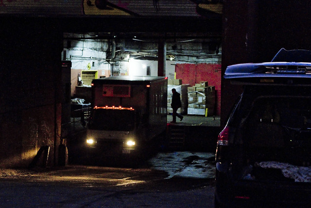
The concrete devastations of Newtown Creek, after the burning thermonuclear eye of God itself has slipped behind and become occluded by the state of New Jersey, are spooky. During daylight, they’re just a cautionary tale with occasional glimpses of terror and wonder, but after darkness settles in on the soot stained masonry offered by the warehouses, factories, and the Great Wall of Calvary Cemetery – one finds himself constantly looking over his shoulder. In the case of the furtive glance captured above, my apprehension was directed towards the spot where Review Avenue transmogrifies into Laurel Hill Blvd. nearby the old and nearly forgotten Penny Bridge. The masonry of the 1894 Penny Bridge is still extant, despite the actual span having been demolished around 1940. The first Penny Bridge, which was little more than a rope walk, opened thereabouts in 1803. It is at Penny Bridge that the presence of the spectral Blissville Banshee was first reported in 1884, as she glided across the oily waters of the Newtown Creek.
I mean – this ain’t Queens Plaza – where legions of vampires are known to drop from the steel rafters of the subways when night comes – but… Blissville after dark is just plain weird.

– photo by Mitch Waxman
It’s not just me who feels this way, either. Last Spring, a buddy of mine – who’s fairly fearless – was walking along this stretch with me at night. He began to ask insistently where we were, and opine that he was completely disoriented despite being in his native borough. Paranoid ideations began to blossom in his mind, and despite my insistence that we were on very familiar ground, anxiety began to overwhelm his reason. A distinct sigh of relief escaped his cranial breathing holes when we emerged onto Greenpoint Avenue after walking down shadow haunted Review Avenue in a generally northern direction.
Perhaps he was experiencing the sort of chronal tunnel vision that I often do.

– photo by Mitch Waxman
Could he have subconsciously known that Van Iderstine’s used to be here, or about Fleischmann’s Yeast with their stable of pneumoniac cattle. The unhealthy condition of these cattle, which attracted the attention of newspaper reporters, hygenicists, and State Board of Health Inspectors from Albany back in 1879, was attributed to being fed only fermented grain produced by the yeast brewers, which slid into their feeding troughs still steaming and straight from from the distillery process. The milk these cows produced was blueish in coloration, and nearly 1% alcohol by volume. This so called “swill milk” was not considered fit for general human consumption, as it was the lowest grade of dairy product commercially available in that era, but was considered a fitting protein source to serve to the orphans and prisoners confined on Blackwells Welfare Roosevelt Island. Nellie Bly might have spent ten days in a madhouse, but I don’t think she mentioned drinking swill milk in her famous exposé.
Van Iderstine’s, for those of you lucky enough to it have never heard of the business which used to inhabit these parts, ran a fat rendering mill hereabouts that was extant until the latter half of the 20th century. Animal parts, spoiled meat, rotten eggs, barrels of butchers blood – all were boiled down in open copper vessels here in Blissville in pursuance of the manufacture of tallow. Ghastly business, that.
– photo by Mitch Waxman
Despite the atmospheric temperatures being low enough to allow one the usage of his full armor – the filthy black raincoat and a stout hat coupled with durable clothing woven from ruggose fibers – one is always aware of his vulnerability and obsequiousness to malign elements of society due to conducting my excursions on foot. It would be a simple matter for one or two stout men to overpower one such as myself, known for his physical cowardice and nervous temperament.
Others with stronger constitution might venture into the shadows of rumor haunted Blissville, but a humble narrator chooses instead to acknowledge his lurking fear and remain naught but a passing outsider and scuttling stranger.
– photo by Mitch Waxman
Upon arriving at the inverse end of Review Avenue, a quick glance over my shoulder revealed a small group of stocky men forming up and pointing in my direction. They were clad in shadow, but the outlines of their group against the sodium lit walls of masonry revealed shapes which did not seem “right.” Discretion being the better part of valor, a humble narrator engaged the services of a passing taxi and made haste for the locked doors of HQ back in Astoria.
The world is a scary place, and the concrete devastations of Western Queens can be scarier than even the pathless deserts of Arabia, where the secrets of cities lost await discovery by the scientifically curious. What might be found… in those wisely abandoned metropolises… if occult rumors are to believed… could easily spark another dark age, and retard the forward progress of mankind – or possibly end civilization itself and condemn mankind to an endless era of ape like barbarity.
As far as the Blissville section of LIC goes – who can guess, all there is, that might be hidden down there?
Upcoming Tours and events
Calvary Cemetery Walking Tour, with Atlas Obscura – Sunday, December 10th, 11 a.m. – 1 p.m.
Explore NYC history, hidden inside sculptural monuments and mafioso grave sites, as you take in iconic city views on this walking tour, with Newtown Creek Alliance Historian Mitch Waxman – details here.
“follow” me on Twitter- @newtownpentacle
familiar rookery
It’s National Eat a Red Apple Day, in these United States.

– photo by Mitch Waxman
The holiday season arrives at Newtown Creek in a manner alien to the neighborhoods surrounding it.
Hereabouts it’s truck tires roasting on a open fire, and that ain’t Jack Frost nipping at your nose kiddo, it’s benzene. Reviewing my year end list of; all the mistakes I’ve newly made, people I’ve offended, stupid things I’ve said in public, or generally humiliated myself somehow – it occurred that I hadn’t checked in on things in DUKBO (Down Under the Kosciuszcko Bridge Onramp) in about a month.
That’s the scene, above, at the spot where Review Avenue transmogrifies into Laurel Hill Blvd. at Penny Bridge, in the Blissville section of Long Island City, in the Borough of Queens.

– photo by Mitch Waxman
Long time readers of this – your Newtown Pentacle – will tell you that this bridge replacement project has been explored before.
Documenting this project has been a long standing project of mine – this 2012 post tells you everything you could want to know about Robert Moses, Fiorella LaGuardia, and the origins of the 1939 model Kosciuszcko Bridge. Just before construction started, I swept through both the Brooklyn and Queens sides of Newtown Creek in the area I call “DUKBO” – Down Under the Kosciuszcko Bridge Onramp. Here’s a 2014 post, and another, showing what things used to look like on the Brooklyn side, and one dating back to 2010, and from 2012 discussing the Queens side – this. Construction started, and this 2014 post offers a look at things. There’s shots from the water of Newtown Creek, in this June 2015 post, and in this September 2015 post, which shows the bridge support towers rising. Additionally, this post from March of 2016 detailed the action on the Queens side. Most recently, here’s one from May of 2016, and one from June of the same year. Here’s one from August of 2016, the December 2016 one, one from March of 2017 which discusses the demolition of the 1939 bridge.
Here’s a post showing what I saw during a pre opening walk through in early April of 2017, and the fanfare surrounding the opening of half of the new bridge in April of 2017, a walk through of the Brooklyn side job site in June of 2017. Here’s some night shots from early July of 2017. A series of posts focused in on the removal of the central truss of the 1939 bridge from the summer of 2017 – a timelapse, some stills, and the barging out of the truss.
Most recently, in late September of 2017, a final series of shots of the old bridge were captured in this post. Acquisition of a souvenir chunk of steel from the 1939 bridge was described in this post, and a video of the “energetic felling” of the approaches on October 1st was offered in this one. Still shots and views of the aftermath from the waters of Newtown Creek from later in the day on Oct. 1 are found in this posting, and the aftermath of the demolition as seen from Calvary Cemetery in LIC’s Blissville section in this post from October 5th.

– photo by Mitch Waxman
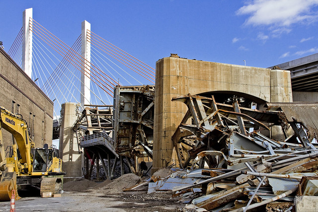
They’re still hard at work demolishing the rubble left behind by the “energetic felling” of the 1939 model Kosciuszcko Bridge at the start of October. These shots were captured from the hills of Calvary Cemetery, if you haven’t already figured that one out yet.

– photo by Mitch Waxman
The reinforced concrete piers that carried the roadway are being demolished using traditional means. That involves the yellow thingamabob being equipped with a chisel hammer, and the guy on the orange lift is spraying water on the concrete to mitigate dust.
The shots of the Queens side of DUKBO in today’s post were shot on November 17th, a Friday.

– photo by Mitch Waxman
On the following Sunday the 19th, a humble narrator scuttled over to the Poison Cauldron in Greenpoint.
That’s my pet name for the section of DUKBO that begins at Kingsland Avenue and heads east past Meeker Avenue to the National Grid fencelines at Lombardy Street. It’s ugly in the Poison Cauldron, I tell you, ugly. Things can’t “get from bad to worse” because they’re already there.

– photo by Mitch Waxman
Similar industrial demolition and scrap removal practices to those in Queens are also occurring on the Brooklyn side. Unlike the Queens side, however, I was able to walk right up to and on the job site. I even used one of the Porta Potties they had stationed to blow some internal ballast (hey, it’s a fairly long walk from Astoria).
– photo by Mitch Waxman
It is odd for me to see light in this spot… this was always an area permeated by shadows, which I now long for.
Additionally, not being chased, threatened, or harassed by the questionable managers of a local waste transfer station as to “whatchu takin pictchas of asshole, getdafukouttaherre” – said operation having been displaced by the construction activity – was not missed at all.

– photo by Mitch Waxman
The only thing going through my mind was that this scene looked like a battle had been fought here.

– photo by Mitch Waxman
I’m sure I’ll have a bit more to tell you about the Kosciuszcko Bridge shortly, as there’s supposed to be a meeting of the Stakeholders Committee coming up in early December.

– photo by Mitch Waxman
There was only so far I wanted to go, as this was and is an active demolition site.
Luckily, that’s what zoom lenses are for.

– photo by Mitch Waxman
The things you see along the Newtown Creek…

– photo by Mitch Waxman
… if you don’t take pictures of them, nobody would believe you.
How can such a place be real, and that so few people even know it exists, this omphalos of New York City?
Upcoming Tours and events
Calvary Cemetery Walking Tour, with Atlas Obscura – Sunday, December 10th, 11 a.m. – 1 p.m.
Explore NYC history, hidden inside sculptural monuments and mafioso grave sites, as you take in iconic city views on this walking tour, with Newtown Creek Alliance Historian Mitch Waxman – details here.
“follow” me on Twitter- @newtownpentacle
local inquisitiveness
There is no National Food day on October 5th!

– photo by Mitch Waxman
As promised in Tuesday’s post, one headed over to Calvary Cemetery in the Blissville section of Long Island City to check out the scene after the October 1st “energetic felling” or demolition of the approaches of the Koscisuzcko Bridge. Given that Laurel Hill, which Calvary Cemetery is carved into, offers some altitude and commanding views of the bridge(s) it’s a pretty good choice as far as “point of view.”

– photo by Mitch Waxman
Long time readers of this – your Newtown Pentacle – will tell you that this bridge replacement project has been explored before.
Documenting this project has been a long standing project of mine – this 2012 post tells you everything you could want to know about Robert Moses, Fiorella LaGuardia, and the origins of the 1939 model Kosciuszcko Bridge. Just before construction started, I swept through both the Brooklyn and Queens sides of Newtown Creek in the area I call “DUKBO” – Down Under the Kosciuszcko Bridge Onramp. Here’s a 2014 post, and another, showing what things used to look like on the Brooklyn side, and one dating back to 2010, and from 2012 discussing the Queens side – this. Construction started, and this 2014 post offers a look at things. There’s shots from the water of Newtown Creek, in this June 2015 post, and in this September 2015 post, which shows the bridge support towers rising. Additionally, this post from March of 2016 detailed the action on the Queens side. Most recently, here’s one from May of 2016, and one from June of the same year. Here’s one from August of 2016, the December 2016 one, one from March of 2017 which discusses the demolition of the 1939 bridge.
Here’s a post showing what I saw during a pre opening walk through in early April of 2017, and the fanfare surrounding the opening of half of the new bridge in April of 2017, a walk through of the Brooklyn side job site in June of 2017. Here’s some night shots from early July of 2017. A series of posts focused in on the removal of the central truss of the 1939 bridge from the summer of 2017 – a timelapse, some stills, and the barging out of the truss.
Most recently, in late September of 2017, a final series of shots of the old bridge were captured in this post. Acquisition of a souvenir chunk of steel from the 1939 bridge was described in this post, and a video of the “energetic felling” of the approaches on October 1st was offered in this one. Still shots and views of the aftermath from the waters of Newtown Creek from later in the day on Oct. 1 are found in this posting.

– photo by Mitch Waxman
On the south side of the job site, the Breeze company’s demolition crews are hard at work, and they were chipping and grinding away at a section which must be blocking the Lower Montauk tracks and the LIRR’s right of way. This section of the tracks is known as “dead man’s curve” due to it having been the site of the legendary Blissville Rail disaster and for the number of laborers employed by the now vacated Phelps Dodge company who thought that they could outrun a freight train.

– photo by Mitch Waxman
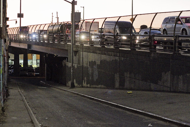
It is somewhat surreal, this current landscape in DUKBO. This view is looking north towards Sunnyside’s 43rd street, which is found on the other side of the Long Island Expressway viaduct that forms a shield wall between the industrial zone and the residential neighborhoods.

– photo by Mitch Waxman
This view is looking eastwards towards West Maspeth, from a prominence inside the cemetery.

– photo by Mitch Waxman
Here’s a link to a FAR larger incarnation of the stitched panorama above, which captures the entire scene. This is a HUGE file, for those of you reading this on your phones, btw.

– photo by Mitch Waxman
I promise this will be the last Kosciuszcko Bridge post for a bit. In my defense though, in my roll as Newtown Creek Alliance Historian, part of my “job” is to record the events of the Superfund era and to document the seismic changes happening along the fabulous Newtown Creek for posterity.
Upcoming Tours and event
Exploring Long Island City, from Luxury Waterfront to Abandoned Factories Walking Tour,
with NY Adventure Club – Saturday, October 7th, 1 p.m. – 3 p.m.
Long Island City is a tale of two cities; one filled with glittering water-front skyscrapers and manicured parks, and the other, a highly active ground transportation & distribution zone vital to the New York economy — which will prevail? With Newtown Creek Alliance Historian Mitch Waxman – details here.
The Hidden Harbors Of Staten Island Boat Tour,
with Working Harbor Committee – Sunday, October 15th, 2 p.m. – 4 p.m.
A very cool boat tour that visits two of the maritime industrial waterways of New York Harbor which adjoin Staten Island and Bayonne in New Jersey – The Kill Van Kull and the Arthur Kill. There will be lots of tugboats, cargo docks, and you’ll get to see multiple bridges from the water – including the brand new Goethals Bridge. I’ll be on the mike, narrating with WHC board member Gordon Cooper – details here.
“follow” me on Twitter- @newtownpentacle
sounds heard
It’s apparently National Soft Taco Day, in these United States.

– photo by Mitch Waxman
Unusual is a Sunday evening post at your Newtown Pentacle, but I wanted to get that piece of Kosciuszcko Bridge demolition video live – asap. Above is a panorama image of the scene as witnessed from about .6 of a mile eastwards of the span at the Maspeth Avenue Plank Road just as the smoke began to clear. I’ve been a busy bee for the last 48 hours, developing shots of the event. I also had to conduct a Newtown Creek tour for a class from the University of Toronto in the afternoon, which was a combination of a walking tour and a boat tour (via the North Brooklyn Boat Club).
The shots in today’s post were captured in the late afternoon of Sunday, October 1st from the waters of the fabulous Newtown Creek, and it’s the scene you’ll observe in DUKBO – Down Under the Kosciuszcko Bridge Onramp.

– photo by Mitch Waxman
North Brooklyn Boat Club is based alongside the Pulaski Bridge (which about 1.5 miles west of the Kosciuszcko Bridge) in Brooklyn’s Greenpoint section. The NBBC has two large canoes which can make bringing small groups of people out onto Newtown Creek possible. After a brief instruction about safety and how to handle the crafts, we all donned life vests and turned the marine radio’s switch to “on” and got onboard.

– photo by Mitch Waxman
The scene in DUKBO is otherworldly, with the highway having settled into neat slabs along the still extant concrete piers of the 1939 Kosciuszcko Bridge.

– photo by Mitch Waxman
This is the Brooklyn side.

– photo by Mitch Waxman
The steel piers are still standing, and will no doubt be disassembled via conventional demolition techniques.

– photo by Mitch Waxman
Looking westwards, along the bulkheads of the National Grid properties at Greenpoint’s border with Bushwick (or East Williamsburg if you must).

– photo by Mitch Waxman
That’s the Queens side, in the shot above.

– photo by Mitch Waxman
This closeup is looking northwards, along the Blissville section of Long Island City’s border with Maspeth, towards Sunnyside. For reference, this used to be the NYPD tow yard.

– photo by Mitch Waxman
As early as Sunday afternoon, there were already wielders with torches (and other labor going on as well) cutting into the rubble. This giant piece of steel truss, as far as I could discern from my vantage, was laying across the Lower Montauk Tracks of the LIRR.

– photo by Mitch Waxman
I imagine getting the right of way clear as quickly as possible is a major priority.
As a note, the students from the University of Toronto we were guiding around had seemingly lost the ability to speak at this point and had become lost in the terrible majesties of the lugubrious Newtown Creek.

– photo by Mitch Waxman
As you’re reading this, I’m heading over to the Newtown Creek to go see what’s going on, and I’ll update you as things progress at the Kosciuszcko Bridge site at this – your Newtown Pentacle.
Upcoming Tours and event
Exploring Long Island City, from Luxury Waterfront to Abandoned Factories Walking Tour,
with NY Adventure Club – Saturday, October 7th, 1 p.m. – 3 p.m.
Long Island City is a tale of two cities; one filled with glittering water-front skyscrapers and manicured parks, and the other, a highly active ground transportation & distribution zone vital to the New York economy — which will prevail? With Newtown Creek Alliance Historian Mitch Waxman – details here.
The Hidden Harbors Of Staten Island Boat Tour,
with Working Harbor Committee – Sunday, October 15th, 2 p.m. – 4 p.m.
A very cool boat tour that visits two of the maritime industrial waterways of New York Harbor which adjoin Staten Island and Bayonne in New Jersey – The Kill Van Kull and the Arthur Kill. There will be lots of tugboats, cargo docks, and you’ll get to see multiple bridges from the water – including the brand new Goethals Bridge. I’ll be on the mike, narrating with WHC board member Gordon Cooper – details here.
“follow” me on Twitter- @newtownpentacle
keen wonder
It’s National Coffee Day, in these United States.

– photo by Mitch Waxman
All the “intel” coming my way indicates that this Sunday morning (Oct. 1), the remaining sections of the Koscisuzcko Bridge will be “energetically demolished” or – to quote Governor Cuomo – “blown up.” The self same intel indicates that 8 a.m. is the target time, but it’s possible that the schedule might shift around a bit depending on circumstance.
I’m recommending that if you want to watch the bridge go boom, you’d either want to be on the Grand Street Bridge looking west, or on the Greenpoint Avenue Bridge looking east. I’m also recommending that if you’ve got a respirator mask, you might want to bring it along, as I’m sure this will kick up a lot of dust when it comes down.

– photo by Mitch Waxman
Scouting out the “exclusion area” which all but FDNY, NYPD, NYS DOT, and their contractors will be forbidden to enter, I took note of where the NYPD had dropped off piles of police barriers for road closure. The cordon is a bit larger than I was originally told, and there is a giant chunk of Newtown Creek and the surrounding neighborhood which will be off limits. I’ve got a different spot to shoot from, but that’s me.
As mentioned above, I’d say the Grand Street or Greenpoint Avenue Bridges would be good – and fairly safe – choices for viewing and or photographing the event. I’m told it’s all going to happen in 8 milliseconds, from detonation to drop.
Grand Street has its charms, looking west at the new bridge with the old one behind it. Morning sun will be lighting the scene, and the Manhattan skyline is visible from there. You’ll see the old bridge directly, from Greenpoint Avenue, but it will be shadowed with the sun behind it.

– photo by Mitch Waxman
I’m sure this will be an enjoyable traffic morning for you drivers, with definite closure for BQE in the morning and a likely closure for the LIE for some interval. There will be mutiple road closures in Greenpoint and West Maspeth as well, which will likely last for awhile as they scoop up all the blown steel and concrete.
The end of an era, lords and ladies…
Upcoming Tours and event
Exploring Long Island City, from Luxury Waterfront to Abandoned Factories Walking Tour,
with NY Adventure Club – Saturday, October 7th, 1 p.m. – 3 p.m.
Long Island City is a tale of two cities; one filled with glittering water-front skyscrapers and manicured parks, and the other, a highly active ground transportation & distribution zone vital to the New York economy — which will prevail? With Newtown Creek Alliance Historian Mitch Waxman – details here.
The Hidden Harbors Of Staten Island Boat Tour,
with Working Harbor Committee – Sunday, October 15th, 2 p.m. – 4 p.m.
A very cool boat tour that visits two of the maritime industrial waterways of New York Harbor which adjoin Staten Island and Bayonne in New Jersey – The Kill Van Kull and the Arthur Kill. There will be lots of tugboats, cargo docks, and you’ll get to see multiple bridges from the water – including the brand new Goethals Bridge. I’ll be on the mike, narrating with WHC board member Gordon Cooper – details here.
“follow” me on Twitter- @newtownpentacle


