Archive for the ‘newtown creek’ Category
strange and roving
Someday, a real rain will come.

– photo by Mitch Waxman
An assertion often offered to Our Lady of the Pentacle is that “NYC never looks so good as it does when it’s wet.”
Long suffering, Our Lady is infinitely patient when confronted with pedantic statements and oft repeated phrases like the one above. One recent storm found a humble narrator hanging out at my local pub, Doyle’s Corner at the Times Square of Astoria, and clicking away while enjoying the shelter offered by an awning.

– photo by Mitch Waxman
The big problem encountered in the pursuit of photographing weather events is obvious. Keeping your lens clean and avoiding the infiltration of water into the internal cavities of the camera. My rig enjoys a certain amount of weather sealing, but a soaking or immersion would be ruinous. It’s always a challenge, and positioning yourself so that the wind is at your back is critical to the operation.

– photo by Mitch Waxman
One of the little tricks I’ve learned over the years is to find “rain shadows.” Manhattan, particularly lower Manhattan, is a good place for this sort of thing. The canyon walls, construction sheds, and narrow streets offer the pedestrian several opportunities for temporary shelter from storms. When I’m walking, my naturally quick pace allows me to walk around the rain drops, but some still inevitably find the camera.

– photo by Mitch Waxman
Umbrellas are an obvious choice, but operating the camera with one hand whilst struggling against wind and rain with the other makes for a dicey proposition. Ponchos are more trouble than they’re worth, and do little to protect the equipment.
A few people over the years have asked me how I achieve the “sharpness” apparent in my photos, and they’re all hoping that I can pass on some sort of technical trick or camera setting they can use when they ask. The simple fact is that I’ve read about and adopted a series of techniques which military snipers employ governing posture and body position. Snipers don’t use umbrellas, or at least they don’t mention them in the army and marine training manuals.

– photo by Mitch Waxman
Snipers and photographers are essentially preparing for their respective tasks in the same manner. You assume a stable position, ready your equipment, look through a view finder, and then push a button.
In the case of photo gathering, you’re collecting light reflecting back from a farway target, whereas snipers are trying to embed a piece of metal in theirs. Regardless, you breathe out before triggering your device to reduce metabolic interference in the process and posture yourself in a manner designed to steady your device.
You’d be surprised at how much you’re actually moving around, even when you believe yourself to be still. On long exposures (anything over 1/60th of a second in my case, although I’ve know individuals who can do hand held 1/30ths) you can actually discern the seismic shocks rippling through the arterial system as caused by the stertorous motion of the heart, necessitating the usage of camera supports such as a tripod.

– photo by Mitch Waxman
Despite the hazards and problems introduced by rain and the lack of light it brings – airborne water droplets, wind, etc. – a humble narrator irregardless stands behind his assertion that “NYC never looks as good as it does when it’s wet.”
Stormy weather adds a dramatic sense of latency to an otherwise pedestrian capture, and should you see some mendicant wandering alongside the road in a filthy and quite saturated black raincoat during a storm somewhere in Western Queens or North Brooklyn – you very well might have spotted me trying to conquer the weather. Maybe the world too, depends on how much coffee I drank that day.
“follow” me on Twitter- @newtownpentacle
these views
Welcome to the Montauk Cutoff, Long Island City.

– photo by Mitch Waxman
Recently, one found himself hitting the tracks just before sunrise. I was there with sanction, accompanied by an MTA employee and entirely “legal.” It should be mentioned, again, that illegal trespass is against a humble narrator’s code, and like a vampire – I need to be invited in to do my thing. You also really, really, don’t want to get caught trespassing up here by the railroad cops, by the way. You also really, really, don’t want to meet the sort of person who camps out along railroad tracks in LIC when you’re all alone in the wee hours.
The Montauk Cutoff in Long Island City was designed to connect the North Shore line with the Montauk Line. The Montauk Line uses the tracks which follow the shoreline of Newtown Creek through Queens, eventually intersecting with the Bushwick Branch and both head for the rail yard at Fresh Pond. The elevated trackway of the Montauk Cutoff crosses Skillman, 49th, 50th, 51st, and Borden Avenues, whereupon it meets a rail bridge called Cabin M which spans Newtown Creek’s tributary Dutch Kills.
The North Shore line used what are approximately the modern LIRR passenger tracks, give or take a few yards, which transverse the Sunnyside Yards and head through Woodside on their way east. The Montauk Cutoff was built for freight, as were the North Shore and Montauk Lines. Passenger service was always a loser for the LIRR. Modern day freight on the LIRR is handled by the New York & Atlantic company.
– photo by Mitch Waxman
The first discussion, which I’ve been able to find at least, about building LIC’s Montauk Cutoff was in 1906 – as part of a series of railroad projects either proposed or already under construction at the start of the 20th century by the Pennsylvania Railroad Company – projects which included Penn Station and Sunnyside Yard. Other documents I’ve examined state that the LIRR was paying taxes to New York State as early as 1912 on the Montauk Cutoff, which suggests that it came into service around the same time that the Sunnyside Yards came online. The surrounding Degnon Terminal wasn’t far behind the rail complex, either, with the Loose Wiles factory and other mega factories opening in the 1920’s.
As is always mentioned, old Mitch ain’t no authority on the whole railroad thing. If there’s something wrong in my little summary, please let me know in the comments and corrections or an errata will be incorporated. I can speak pretty intelligently about the maritime/locomotive complex around Newtown Creek, but I’ll admit to having vast gaps on the particular subject of the iron road. That was my pal Bernie Ente’s area of expertise.
For a historic series of shots, maps, and technical descriptions of anything involving the LIRR, you are going to have to visit the fairly excellent trainsarefun.com. Here’s their Montauk Cutoff Page.
Another set of maps and historic shots can be accessed at an equally fantastic site called arrts-arrchives.com. Here’s their Montauk Cutoff page.
I’ve written about the Smiling Hogshead Ranch before, which sits on the interchange between the Degnon Terminal Railway and the Montauk Cutoff, over at my old Brownstoner Queens column.

– photo by Mitch Waxman
The view from up on the Montauk Cutoff is unique. That big parking lot at the bottom of the shot above is a UPS shipping center, the one on 49th avenue. Rearing above and behind it is the Queens Midtown Expressway section of the Long Island Expressway, which arches up and over Dutch Kills some 106 feet from its beginning at the Queens Midtown Tunnel – which is around a half mile away.
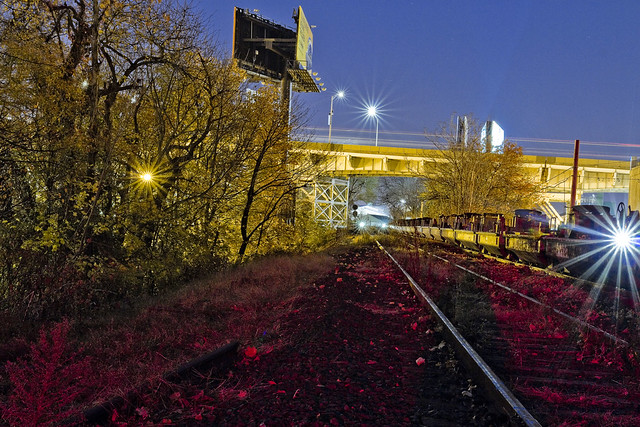
My MTA companion and I met up at the Smiling Hogshead Ranch at 5:30 in the morning to get these shots, which gave me a solid hour to work in absolute pitch darkness up on the tracks. The shots in today’s post are obviously tripod shots, and long exposures. Leaving the shutter open for 20-30 seconds at a pop, you can gather a tremendous amount of light and color, but the hot spots of electric street lighting always cause certain problems. Compensation for this is to move the aperture into “hyperfocal” range, f11 and narrower, which is counterintuitive for night shots but nevertheless effective. It also produces those neat little star bursts around the lights.

– photo by Mitch Waxman
So, why was I out on a chilly November morning with an MTA property manger, walking on a century old rail spur in Long Island City?
The MTA has decided to “abandon” this line. Abandon doesn’t mean the same thing in “railroad” as in does in english. It means that the agency has no current plans for the line and wishes to free itself of the duties necessitated in maintaining it as functional track. It means that the MTA will retain ownership of the Montauk Cutoff, and can at any time reactivate the pathway should “future use” require it. Given the speed with which rail projects generally move, however, that means a window of at least a couple of decades of inactivity awaits the property no matter what happens.
Accordingly, MTA has issued a “Request for Expressions of Interest,” or RFEI, regarding the Montauk Cutoff and is seeking potential lessees for the space.

– photo by Mitch Waxman
As defined in the RFEI document, the MTA is seeking out creative uses of the land with an eye towards community improvement. The agency has set down a few ground rules for any potential lessee of the site, many of which are quite expensive – such as insurance, utility service – those sorts of things. The property, as defined in the RFEI, includes the Smiling Hogshead Ranch – who currently lease and pay insurance on the parcel in which the community garden is operated.
Before certain web masters start pointing their fingers and shouting “j’accuse” at me while spinning a conspiratorial tale, Smiling Hogshead is indeed associated with Newtown Creek Alliance, as am I. You can absolutely bet that I’m a fan of SHHR’s operations and programming, and friends with a lot of their members. Long Island City needs every bit of green space it can get, which is how I finally get around to explaining why me and the MTA guy were here on the day before Thanksgiving and just before sunrise.

– photo by Mitch Waxman
A “Request for an Expression of Interest”? You can say that I’m interested. I’m interested in seeing this trackway converted over to green space, in much the same way that the Degnon Spur on Pearson and Skillman – a weedy dumping ground and homeless camp – was turned into a lush garden by a group of dedicated volunteers.
Can you imagine what a group like Smiling Hogshead’s could do up here?
If you want to get in on the conversation, or contribute some time and knowledge to the project – shape the future, as it were – whatcha doing on the 2nd of December? A bunch of us are going to attend a “visioning meeting” at Nomad Cycle (47-10 Austell Pl, Queens, NY 11101) which is set to happen between 6:30 and 8:30 p.m.

– photo by Mitch Waxman
My companion and I had discussed the possibility of getting up here in the pre dawn hours, and a couple of previous appointments had to be cancelled on account of weather. We had met on a walk through of the site which MTA had conducted back in October for parties interested in acquiring the land, an excursion which occurred just before solar noon – which is not the most efficacious time to photograph LIC. I made the case to him that a “proper” set of photos would be needed for this project and quite handy to boot, which my new friend at the agency agreed with. Hence, where we were, when we were, and why we met up in the dark on Skillman Avenue on the day before Thanksgiving.
The wrinkle in this potential project is this – it doesn’t necessarily have to become a green space. Anyone can “express interest” in the Montauk Cutoff, and as long as their proposed project meets the requirements set aside by the MTA, it will be considered a viable option.
I see this as being a frankly huge opportunity to create an enormous acreage of green space in an otherwise completely barren industrial area which can be best described as a “devastation of concrete.” My interest in this thing is simple – this property touches Dutch Kills, where the borders of the “abandoned” section ends, which is “my house.”

– photo by Mitch Waxman
The Montauk Cutoff begins at Sunnyside Yard, and at its southeastern edge connects to the M Cabin truss bridge over Dutch Kills which connects to the Blissville Yard, which in turn feeds the tracks that travel under the Greenpoint and Kosciuszko Bridges to Maspeth, Ridgwood, and all points east. The RFEI states that the M Cabin bridge will be opened, and secured in that position, and that a barrier of some sort will be erected at the edge of the Montauk Cutoff’s lot.
Additionally, I cannot begin to, nor have I ever believed that this is the original bridge on this site. I’ve got some Intel that suggests the early 1940’s for its origins, but nothing solid enough to to stick a pin into. The original early 20th century bridge is long gone at any rate.

– photo by Mitch Waxman
I can tell you with some certainty that the nearby DB Cabin rail bridge is from 1919, and is a swing bridge that hasn’t opened since 2002. My pal Bernie, mentioned above as having been THE authoritative source on all things rail around LIC, told me once or twice that two industrial wreckers are required to tow it from either side to open the bridge. The swing bridges motors are non functional, something that has caused no small amount of grief for the EPA’s Superfund investigators. DB Cabin allows access from the Wheelspur Yard to the Blissville Yard and the Montauk Line.
Like I said, Newtown Creek.

– photo by Mitch Waxman
Looking northwards along Dutch Kills, at a scene familiar and loved by long time readers of this – your Newtown Pentacle. That’s the Borden Avenue Bridge, with the LIE above, spanning Dutch Kills. I’ve been writing about this neighborhood for years, it’s one of my favorite locations in New York City. The Montauk Cutoff leads directly to this spot, which in my mind directly connects it to the environmental problems of the Newtown Creek watershed.
Know how I’ve been rattling on for years about “combined sewer outfalls” and the problems presented to the ancient sewer system during rain events? Montauk Cutoff represents an opportunity to create a nearly four acre long green sponge that can drink up a significant amount of the storm water that carries garbage, grease, and poop into this water.

– photo by Mitch Waxman
The Montauk Cutoff. This is a once in a generation opportunity to do something right for the environment in the ruined biome of Long Island City. Every elected official I’ve spoken to about this idea is “into it” although they haven’t made any public declarations yet (too early in the process to bring them in) and recently – Community Board 2’s environmental committee voted to support the use of these tracks as “green infrastructure.”
Want to get involved in the future of the Montauk Cutoff? As mentioned above, a “visioning meeting” which be taking place at LIC’s Nomad Cycle (47-10 Austell Pl, Queens, NY 11101) on December 2nd, between 6:30 and 8:30 p.m.
“follow” me on Twitter- @newtownpentacle
continuous system
Holiday pretty pictures, in today’s post.

– photo by Mitch Waxman
That’s the Long Island Railroad crossing Borden Avenue in LIC in the shot above, which was captured around ten years ago. I take a lot of pictures of trains, mind you, but the one above remains one of my favorites. It’s number 401, btw.

– photo by Mitch Waxman
Number 420 was observed at the Sunnyside Yards’s Harold Interlocking not too long ago, and funnily enough it was smoking up. If you don’t get the joke, just google 420 for what it means to our inebriated friends.

– photo by Mitch Waxman
411 doesn’t just provide directory assistance, it also transits from the Hunters Point yard in LIC to the Hunters Point stop at the southern end of the Sunnsyide Yards – the only place in the entire 183 square acre rail yard where you can actually board a train.
Back Monday with some slightly more substantive content, and may all your Friday’s be black.
“follow” me on Twitter- @newtownpentacle
babbling over
National Feasting week is upon us, eat long and hard, lords and ladies.

– photo by Mitch Waxman
Pictured above is the magical Chrysler Building, surrounding by the dross modernity of Manhattan. One of the few shots captured in the City after a recent crossing the Queensboro Bridge, which was detailed in recent posts. Odds are that few, or any, of you reading this post will actually be in New York for the holiday weekend – so Newtown Pentacle will be going into its traditional holding pattern for the next few days.
Don’t worry, I’ll still be publishing, but it’s just going to some pretty pictures for a few days, without much meat on the bone.

– photo by Mitch Waxman
Personally, your humble narrator will be in town.
Holiday weekends such as Thanksgiving are a fantastic time to avoid family and friends for me, and to wander aimlessly about in the concrete devastations of the nearly deserted industrial quarters of the Newtown Creek. There’s quite a few irons in the fire, however, and one fairly earth shattering project in LIC which I’m extremely excited about which I’ll fill y’all in on when you settle back into your desk chairs on Monday next.

– photo by Mitch Waxman
Suffice to say that it involves a defunct railroad trackway, LIC, and the MTA itself. I’d tell you more, but that would technically be “spoilers.”
Have a happy and a healthy one, lords and ladies.
“follow” me on Twitter- @newtownpentacle
leftward fork
Down Under the Kosciuszko Bridges Onramps – DUKBO, part 2 – in today’s post.

– photo by Mitch Waxman
As described in my last post, a visit to the NYS DOT’s Kosciuszko Bridge project site was arranged for members of the “Stakeholders Advisory Group” that is connected to the project. Community members, business owners, representatives of municipal agencies and elected officialdom, the SAG’s job is to bring concerns to the attention of the project managers of the K Bridge project. Anyone interested in finding out more about the project straight from the source, or who feel that they should be involved, can contact the Community Liason’s office.
There’s all sorts of job opportunities available on the project as well, for those of you involved with the trades, but quite obviously that’s not something a humble narrator can help you out with.

– photo by Mitch Waxman
On the left side of the shot above is the Robert Moses 1939 era “New Meeker Avenue” Bridge, which was rechristened in 1940 as the Kosciuszko Bridge. Its original purpose, as far as Mayor LaGuardia was concerned, was to allow egress for the multitudes of Brooklyn to the 1939 Worlds Fair over in what we refer to as “Flushing Meadow Corona Park.” For Moses, it was the first link in a chain which he originally called the “Brooklyn Queens Connecting Highway” which modernity knows as the Brooklyn Queens Expressway.
Technical note – the Gowanus Expressway actually was the first part of the modern BQE to be built, but my understanding is that Moses didn’t intend for it to be part of the BQE – it was incorporated into the larger expressway when the Verazzano was being built.
That’s my understanding, I might be incorrect, so “grain of salt.”

– photo by Mitch Waxman
The Brooklyn side of the Newtown Creek enjoys a rather shallow firmament, as a craton which underlies this section of western Long Island – essentially an enormous glacial erratic or boulder – is only about sixty to seventy feet below the surface and sits at a fairly oblique angle relative to the land.
The Queens side is basically a giant pile of mud more than a hundred feet deep, and the bedrock craton on the northern or Queens side of the Creek is more difficult to access. The original or 1939 Kosciuszko Bridge piers on the Queens side are essentially founded on concrete blocks floating in this mud. The new bridge will be anchored in the bedrock instead. (This, incidentally, isn’t something I know from the SAG, rather its “history” stuff).
The piles seen above are in various stages of being driven down to the craton – or bedrock.

– photo by Mitch Waxman
As we neared the shoreline of Newtown Creek, I mentioned to several people that this was one of the spots which I had never actually set foot upon. There used to be a carting company here which was… let’s just say that they didn’t like people with cameras wandering around, and that the few times which I did approach their fencelines over the years resulted in my being literally threatened by several mustachioed people with a distinctly Italian variant of the North Brooklyn accent. As I often say, I only run when someone or something is chasing me, and after meeting these fellows I was running.
The metallic box pictured above was a pretty cool thing, however.

– photo by Mitch Waxman
The new Kosciuszko Bridge is going to be a “cable stay” bridge, the first of its kind in NYC. The device pictured above is what the cables will be running through. The cables will leave their anchorage and climb up and over the towers, feeding down to and supporting the roadway over the water. This is a pretty important bit of kit, obviously, as the BQE carries a couple of hundred thousand vehicles a day over Newtown Creek.

– photo by Mitch Waxman
Looking towards West Maspeth’s border with Blissville near Calvary Cemetery, across the lugubrious Newtown Creek. The Queens side of the job is on schedule, but the process isn’t quite as far along on the north shore. You can see the piers which will carry the road, but the towers which will support the cables haven’t been erected yet.
There’s a whole lot of environmental “ugly” in the shot above, the ground to the right is part of the Phelps Dodge State Superfund site. The sediments in this section of the Newtown Creek are rife with organocoppers and all sorts of bad stuff, which is why the water and what lies below is part of the Federal Superfund site, and not too long ago it was determined that the chemical condition of the land at Phelps Dodge was too extreme for it to serve as a parking lot for USPS trucks.

– photo by Mitch Waxman
Looking up the dizzying heights of the two concrete towers of the Brooklyn side, which are still rising. There were gangs of laborers working up there, who are clearly made of sterner stuff than I. I’d need the Fire Department to come rescue me, as paralysis would set in due to the height.

– photo by Mitch Waxman
Looking back towards the south/south west, along the ramps of the Kosciuszko Bridges. You can really see the difference in the two spans’ deck heights in the shot above. The DOT folks tell me that this is to ensure a smoother experience for drivers, as they won’t have to crest quite as high an incline. Additionally, the BQE will no longer compress to three lanes from four and then back to four again on the new bridge. There is also meant to be an entirely dedicated approach to the Long Island Expressway when the job is finished.

– photo by Mitch Waxman
Our visit over, the Stakeholders Advisory Group was escorted back to Meeker Avenue, where we turned in our hard hats and other safety gear.
“follow” me on Twitter- @newtownpentacle


