Posts Tagged ‘Montauk Cutoff Rail Bridges’
dazedly following
Wednesday

– photo by Mitch Waxman
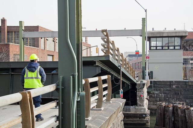
Seldom do I head down to the spot where these shots were gathered along Dutch Kills, due to the fact that I’m usually by myself when I’m out shooting. There’s a real chance of a snapped ankle on this path, or some other injury, and I honestly don’t know how I’d explain to the 911 operator where I was if I needed help (and I’ve thought this through). Thereby, since my pal Val was with me on this particular outing, caution was thrown to the wind. That’s the DB Cabin rail bridge, which – if memory serves – was built in the 1920’s, and is a still VERY active crossing for Lower Montauk line Long Island Railroad rail traffic over the mouth of the Dutch Kills tributary of Newtown Creek.
I seriously do not ever want to have to have the FDNY rescue me from some stupid injury in an out of the way place like this. It would be so embarrassing, and I’d never hear the end of it from my firefighter and or cop friends. Officer Pinky and Fireman Matt at the local bar here in Astoria – in particular – would “take the piss” as my British wife would say, since I regularly bust their balls.
Btw, he’s Officer Pinky because despite being a hulking meathead of a cop, this particular patrolman had a fractured pinky finger which put him on the disabled list for several months. The guy is built like a professional wrestler, but he had that little finger stuck out on a splint with a hand posture that reminded one of “tea time.”

– photo by Mitch Waxman
The bridge pictured above is part of the Montauk Cutoff, and is dubbed “Cabin M.” It’s inactive, and the tracks it’s connected to are no longer connected to Sunnyside Yards on the western side of the cutoff. It’s a single bascule rail drawbridge, and – again, of memory serves – dates back to the 1930’s. MTA was planning on demolishing it prior to COVID, but who knows what the future holds?
Eric Adams is said to be able to see through time and gaze at all of human history, in the manner of Dune’s God Emperor Leto the second, but he never had to sacrifice his humanity for this prescience like that fictional character from Frank Herbert’s sci-fi opus. Adams just had to ride a bike once and then go Vegan. The new Mayor will be an eidolon whom the children of New York will sing fluting aspirational songs about. Just ask him.

– photo by Mitch Waxman
From up on the bridge, my pal Val yelled down to me that it was time to split, and asked if I was interested in grabbing a meal. We headed over to the entirely adequate Bel Aire diner on Broadway and 21st street in Astoria and I quaffed a pizza burger deluxe. Yum.
More tomorrow, at this – your Newtown Pentacle.
“follow” me on Twitter- @newtownpentacle
Buy a book!
“In the Shadows at Newtown Creek,” an 88 page softcover 8.5×11 magazine format photo book by Mitch Waxman, is now on sale at blurb.com for $30.
subtler properties
Thursday

– photo by Mitch Waxman
During a moon lit night at Dutch Kills, one found himself feeling kind of minimalist. This isn’t so easy in an environment as visually complicated as the Newtown Creek watershed. One found himself fascinated by ambient lighting, cast colors, and vibe.
The shot above is looking eastwards along the Borden Avenue Bridge, towards Review Avenue, with the eye of Hecate sitting swollen and glowing in the spring sky. This was a supermoon, by the way, one of several we will be experiencing between now and autumn.

– photo by Mitch Waxman
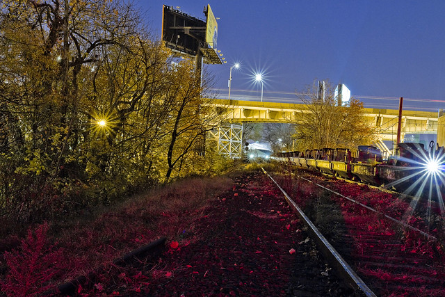
The Montauk Cutoff is pictured above, drenched in automotive brake light. One of the reasons behind my upgrade of camera equipment in the last six months revolves around being able to capture this sort of scene minus the usage of tripods or other camera support.
This shot is also from Borden Avenue in Long Island City, for the curious.

– photo by Mitch Waxman
That’s also the Montauk Cutoff in the shot above, with the point of view changed to the “Empty Corridor” under the Long Island Expressway.
Back tomorrow with more at this – your Newtown Pentacle.
“follow” me on Twitter- @newtownpentacle
Buy a book!
“In the Shadows at Newtown Creek,” an 88 page softcover 8.5×11 magazine format photo book by Mitch Waxman, is now on sale at blurb.com for $30.
correlated causeways
Eleven bridges, one creek.

– photo by Mitch Waxman
Pulaski Bridge is the first span you encounter, when you’ve left the East River and embarked on a journey down the fabulous Newtown Creek. A double bascule drawbridge, and electrically powered, the Pulaski Bridge connects 11th street in Long Island City with McGuinness Blvd. to the south in Brooklyn’s Greenpoint. Built in 1954, the Pulaski Bridge is owned and operated by the New York City Department of Transportation or “NYC DOT.” The Pulaski Bridge carries five lanes of traffic, plus a dedicated bicycle lane and a separate pedestrian pathway. It overflies the Queens Midtown Tunnel and Long Island Expressway, as well as active railroad tracks found on Borden Avenue.

– photo by Mitch Waxman
DB Cabin acts as a gatekeeper to the Dutch Kills tributary of Newtown Creek. It’s a railroad swing bridge owned by the Long Island Railroad, and connects two rail yards – the Wheelspur Yard (to the west, or left in the shot above) and the Blissville Yard – across the water. Both rail yards and the bridge itself are part of the LIRR’s Lower Montauk tracks. DB Cabin dates back to the 1890’s and is in a terrible state of repair. The swing bridge’s motors are nonfunctional, which isolates the Dutch Kills tributary from maritime traffic, and from the rest of the Newtown Creek.

– photo by Mitch Waxman
Cabin M is just to the north of DB Cabin on Dutch Kills, and the single bascule drawbridge connects the Montauk Cutoff with the Blissville Yard mentioned above. The Montauk Cutoff is an elevated track which used to provide a connection between the LIRR’s Main Line tracks at the nearby Sunnyside Yards with the Lower Montauk tracks along the north (or Queens side) shoreline of Newtown Creek. The 2020 Capital Plan just released by the Long Island Railroad’s owner – The MTA – includes funding to demolish Cabin M.

– photo by Mitch Waxman
Borden Avenue Bridge is owned by the NYC DOT, and is one of just two retractile bridges in NYC (the other being the Carroll Street Bridge over the Gowanus Canal). Built in 1908 to replace an earlier wooden drawbridge (1868) at the intersection of Borden Avenue and Dutch Kills, Borden Avenue Bridge received extensive upgrades and structural repairs in 2010 and 2011, and had its electronic components destroyed by flooding during Hurricane Sandy. Another round of repairs and upgrades began in 2019, which included asbestos abatement work.

– photo by Mitch Waxman
The Long Island Expressway is 71 miles long, and is operationally managed in three sections. The Queens Midtown Expressway is how it’s owners, the New York State Department of Transportation, refer to the section found between the Queens Midtown Tunnel and Greenpoint Avenue in Long Island City. This section is elevated, rising to 106 feet above the waters of Dutch Kills. The LIE truss pictured above handles some 87.7 thousand daily vehicle trips, or 32 million annually, to and from Manhattan,
– photo by Mitch Waxman
Hunters Point Avenue Bridge is due north west of Borden Avenue Bridge and the LIE truss. It’s a single bascule drawbridge, owned by the NYC DOT. Replacing an earlier wooden draw bridge that was opened and closed by a donkey walking on a wheel, the Hunters Point Avenue Bridge was built in 1910. Back then, it was a double bascule bridge, but a rebuild in the 1980’s simplified the mechanism to a single bascule. The masonry of the bridge is original to the 1910 design.

– photo by Mitch Waxman
The Greenpoint Avenue Bridge is found some 1.37 miles from Newtown Creek’s intersection with the East River, and roughly a half mile from the mouth of Dutch Kills. It’s a double bascule bridge, built in 1987, and owned and operated by the NYC DOT. There have been many Greenpoint Avenue Bridges, dating back to the first one built by Greenpoint’s town father Neziah Bliss back in 1850, but that one was called the “Blissville Bridge.” The Greenpoint Avenue Bridge is a traffic machine, carrying 28.3 thousand vehicle trips a day, or about ten million a year. Most of that traffic takes the form of heavy trucking.

– photo by Mitch Waxman
The brand new Kosciuszko Bridge(s) replaced a 1939 vintage truss bridge that carried the Brooklyn Queens Expressway over Newtown Creek and are found some 2.1 miles from the East River. The NYS DOT is busy putting the finishing touches on the new cable stay bridge’s construction. In addition to the… ahem… high speed traffic lanes of the BQE, there is also a pedestrian and bicycle pathway found on the new Kosciuszko Bridge which connects 43rd street in Queens’s Sunnyside section with Meeker Avenue in Brooklyn’s Greenpoint.

– photo by Mitch Waxman
The Grand Street Bridge is a swing bridge connecting Maspeth’s Grand Avenue in Queens with East Williamsburg/Bushwick’s Grand Street in Brooklyn. 3.1 miles back from the East River, in a section of Newtown Creek once called “White’s Dock,” the NYC DOT have recently announced plans to replace this 1909 beauty – which is actually the third bridge to occupy this spot. Damage from Hurricane Sandy, and the narrow roadways with height restrictions that the bridge offers, have pretty much sealed its fate. It will be missed.
This is where the main spur of Newtown Creek ends, as a note. Directly east is a truncated tributary called the East Branch, and another tributary called English Kills makes a hard turn to the south just before you encounter Grand Street Bridge.

– photo by Mitch Waxman
Metropolitan Avenue Bridge is a double bascule drawbridge that crosses the English Kills tributary of Newtown Creek, and is owned by the NYC DOT. Metropolitan Avenue was originally built as a private toll road in 1813, and the first bridge here was a part of the “Williamsburg and Jamaica Turnpike.” The current Metropolitan Avenue Bridge was built in 1931, although it has received significant alterations in 1976, 1992, 2006, and again in 2015. The 2015 alterations?
You guessed it, Hurricane Sandy strikes again.

– photo by Mitch Waxman
Montrose Avenue Rail Bridge is the final crossing found over the waters of Newtown Creek and its tributaries. Some 3.7 miles back from the East River, it’s the property of the Long Island Railroad and used for freight service on their Bushwick Branch tracks. A truss bridge, or trestle if you must, my understanding of things are that whereas the trackway and parts of the rail bridge date back to approximately 1924… there has been quite a lot of work done on the thing which I have not been able to fully document so rather than fill in blanks with assumptions – I’m just going to say that I don’t know everything… yet.
It’s an active track, it should be mentioned.
“follow” me on Twitter- @newtownpentacle
Buy a book!
“In the Shadows at Newtown Creek,” an 88 page softcover 8.5×11 magazine format photo book by Mitch Waxman, is now on sale at blurb.com for $30.
these views
Welcome to the Montauk Cutoff, Long Island City.

– photo by Mitch Waxman
Recently, one found himself hitting the tracks just before sunrise. I was there with sanction, accompanied by an MTA employee and entirely “legal.” It should be mentioned, again, that illegal trespass is against a humble narrator’s code, and like a vampire – I need to be invited in to do my thing. You also really, really, don’t want to get caught trespassing up here by the railroad cops, by the way. You also really, really, don’t want to meet the sort of person who camps out along railroad tracks in LIC when you’re all alone in the wee hours.
The Montauk Cutoff in Long Island City was designed to connect the North Shore line with the Montauk Line. The Montauk Line uses the tracks which follow the shoreline of Newtown Creek through Queens, eventually intersecting with the Bushwick Branch and both head for the rail yard at Fresh Pond. The elevated trackway of the Montauk Cutoff crosses Skillman, 49th, 50th, 51st, and Borden Avenues, whereupon it meets a rail bridge called Cabin M which spans Newtown Creek’s tributary Dutch Kills.
The North Shore line used what are approximately the modern LIRR passenger tracks, give or take a few yards, which transverse the Sunnyside Yards and head through Woodside on their way east. The Montauk Cutoff was built for freight, as were the North Shore and Montauk Lines. Passenger service was always a loser for the LIRR. Modern day freight on the LIRR is handled by the New York & Atlantic company.
– photo by Mitch Waxman
The first discussion, which I’ve been able to find at least, about building LIC’s Montauk Cutoff was in 1906 – as part of a series of railroad projects either proposed or already under construction at the start of the 20th century by the Pennsylvania Railroad Company – projects which included Penn Station and Sunnyside Yard. Other documents I’ve examined state that the LIRR was paying taxes to New York State as early as 1912 on the Montauk Cutoff, which suggests that it came into service around the same time that the Sunnyside Yards came online. The surrounding Degnon Terminal wasn’t far behind the rail complex, either, with the Loose Wiles factory and other mega factories opening in the 1920’s.
As is always mentioned, old Mitch ain’t no authority on the whole railroad thing. If there’s something wrong in my little summary, please let me know in the comments and corrections or an errata will be incorporated. I can speak pretty intelligently about the maritime/locomotive complex around Newtown Creek, but I’ll admit to having vast gaps on the particular subject of the iron road. That was my pal Bernie Ente’s area of expertise.
For a historic series of shots, maps, and technical descriptions of anything involving the LIRR, you are going to have to visit the fairly excellent trainsarefun.com. Here’s their Montauk Cutoff Page.
Another set of maps and historic shots can be accessed at an equally fantastic site called arrts-arrchives.com. Here’s their Montauk Cutoff page.
I’ve written about the Smiling Hogshead Ranch before, which sits on the interchange between the Degnon Terminal Railway and the Montauk Cutoff, over at my old Brownstoner Queens column.

– photo by Mitch Waxman
The view from up on the Montauk Cutoff is unique. That big parking lot at the bottom of the shot above is a UPS shipping center, the one on 49th avenue. Rearing above and behind it is the Queens Midtown Expressway section of the Long Island Expressway, which arches up and over Dutch Kills some 106 feet from its beginning at the Queens Midtown Tunnel – which is around a half mile away.
My MTA companion and I met up at the Smiling Hogshead Ranch at 5:30 in the morning to get these shots, which gave me a solid hour to work in absolute pitch darkness up on the tracks. The shots in today’s post are obviously tripod shots, and long exposures. Leaving the shutter open for 20-30 seconds at a pop, you can gather a tremendous amount of light and color, but the hot spots of electric street lighting always cause certain problems. Compensation for this is to move the aperture into “hyperfocal” range, f11 and narrower, which is counterintuitive for night shots but nevertheless effective. It also produces those neat little star bursts around the lights.

– photo by Mitch Waxman
So, why was I out on a chilly November morning with an MTA property manger, walking on a century old rail spur in Long Island City?
The MTA has decided to “abandon” this line. Abandon doesn’t mean the same thing in “railroad” as in does in english. It means that the agency has no current plans for the line and wishes to free itself of the duties necessitated in maintaining it as functional track. It means that the MTA will retain ownership of the Montauk Cutoff, and can at any time reactivate the pathway should “future use” require it. Given the speed with which rail projects generally move, however, that means a window of at least a couple of decades of inactivity awaits the property no matter what happens.
Accordingly, MTA has issued a “Request for Expressions of Interest,” or RFEI, regarding the Montauk Cutoff and is seeking potential lessees for the space.

– photo by Mitch Waxman
As defined in the RFEI document, the MTA is seeking out creative uses of the land with an eye towards community improvement. The agency has set down a few ground rules for any potential lessee of the site, many of which are quite expensive – such as insurance, utility service – those sorts of things. The property, as defined in the RFEI, includes the Smiling Hogshead Ranch – who currently lease and pay insurance on the parcel in which the community garden is operated.
Before certain web masters start pointing their fingers and shouting “j’accuse” at me while spinning a conspiratorial tale, Smiling Hogshead is indeed associated with Newtown Creek Alliance, as am I. You can absolutely bet that I’m a fan of SHHR’s operations and programming, and friends with a lot of their members. Long Island City needs every bit of green space it can get, which is how I finally get around to explaining why me and the MTA guy were here on the day before Thanksgiving and just before sunrise.

– photo by Mitch Waxman
A “Request for an Expression of Interest”? You can say that I’m interested. I’m interested in seeing this trackway converted over to green space, in much the same way that the Degnon Spur on Pearson and Skillman – a weedy dumping ground and homeless camp – was turned into a lush garden by a group of dedicated volunteers.
Can you imagine what a group like Smiling Hogshead’s could do up here?
If you want to get in on the conversation, or contribute some time and knowledge to the project – shape the future, as it were – whatcha doing on the 2nd of December? A bunch of us are going to attend a “visioning meeting” at Nomad Cycle (47-10 Austell Pl, Queens, NY 11101) which is set to happen between 6:30 and 8:30 p.m.

– photo by Mitch Waxman
My companion and I had discussed the possibility of getting up here in the pre dawn hours, and a couple of previous appointments had to be cancelled on account of weather. We had met on a walk through of the site which MTA had conducted back in October for parties interested in acquiring the land, an excursion which occurred just before solar noon – which is not the most efficacious time to photograph LIC. I made the case to him that a “proper” set of photos would be needed for this project and quite handy to boot, which my new friend at the agency agreed with. Hence, where we were, when we were, and why we met up in the dark on Skillman Avenue on the day before Thanksgiving.
The wrinkle in this potential project is this – it doesn’t necessarily have to become a green space. Anyone can “express interest” in the Montauk Cutoff, and as long as their proposed project meets the requirements set aside by the MTA, it will be considered a viable option.
I see this as being a frankly huge opportunity to create an enormous acreage of green space in an otherwise completely barren industrial area which can be best described as a “devastation of concrete.” My interest in this thing is simple – this property touches Dutch Kills, where the borders of the “abandoned” section ends, which is “my house.”

– photo by Mitch Waxman
The Montauk Cutoff begins at Sunnyside Yard, and at its southeastern edge connects to the M Cabin truss bridge over Dutch Kills which connects to the Blissville Yard, which in turn feeds the tracks that travel under the Greenpoint and Kosciuszko Bridges to Maspeth, Ridgwood, and all points east. The RFEI states that the M Cabin bridge will be opened, and secured in that position, and that a barrier of some sort will be erected at the edge of the Montauk Cutoff’s lot.
Additionally, I cannot begin to, nor have I ever believed that this is the original bridge on this site. I’ve got some Intel that suggests the early 1940’s for its origins, but nothing solid enough to to stick a pin into. The original early 20th century bridge is long gone at any rate.

– photo by Mitch Waxman
I can tell you with some certainty that the nearby DB Cabin rail bridge is from 1919, and is a swing bridge that hasn’t opened since 2002. My pal Bernie, mentioned above as having been THE authoritative source on all things rail around LIC, told me once or twice that two industrial wreckers are required to tow it from either side to open the bridge. The swing bridges motors are non functional, something that has caused no small amount of grief for the EPA’s Superfund investigators. DB Cabin allows access from the Wheelspur Yard to the Blissville Yard and the Montauk Line.
Like I said, Newtown Creek.

– photo by Mitch Waxman
Looking northwards along Dutch Kills, at a scene familiar and loved by long time readers of this – your Newtown Pentacle. That’s the Borden Avenue Bridge, with the LIE above, spanning Dutch Kills. I’ve been writing about this neighborhood for years, it’s one of my favorite locations in New York City. The Montauk Cutoff leads directly to this spot, which in my mind directly connects it to the environmental problems of the Newtown Creek watershed.
Know how I’ve been rattling on for years about “combined sewer outfalls” and the problems presented to the ancient sewer system during rain events? Montauk Cutoff represents an opportunity to create a nearly four acre long green sponge that can drink up a significant amount of the storm water that carries garbage, grease, and poop into this water.

– photo by Mitch Waxman
The Montauk Cutoff. This is a once in a generation opportunity to do something right for the environment in the ruined biome of Long Island City. Every elected official I’ve spoken to about this idea is “into it” although they haven’t made any public declarations yet (too early in the process to bring them in) and recently – Community Board 2’s environmental committee voted to support the use of these tracks as “green infrastructure.”
Want to get involved in the future of the Montauk Cutoff? As mentioned above, a “visioning meeting” which be taking place at LIC’s Nomad Cycle (47-10 Austell Pl, Queens, NY 11101) on December 2nd, between 6:30 and 8:30 p.m.
“follow” me on Twitter- @newtownpentacle
grim facade
More on the dock delivery dilemma at Dutch Kills with HarborLab, in today’s post.

– photo by Mitch Waxman
Once we passed under the derelict railroad swing bridge – DB Cabin – at the mouth of Dutch Kills, it was pretty much smooth sailing for the crew from HarborLab to steer the new dock designated for the usage of faculty and students from LaGuardia Community College to its destination. Dutch Kills is about a mile long, and flows back towards Sunnyside Yards in direction of Queens Plaza. In its primeval incarnation, this tributary of Newtown Creek once had several tributaries of its own, and fed a swampy wetland that was nearly 40 square acres in size. It terminated its navigable path at about 29th to 30th street and 40th avenue in the neighborhood of Dutch Kills.
That’s across the street from St. Patrick’s Romanc Catholic Church and around a block from where Jackson Avenue becomes Northern Blvd., if you need a landmark. The waterway was truncated to its current bulkheads in the first decades of the 20th century during the construction of the Sunnyside Yards, Queensborough Bridge/Queens Plaza, and the Degnon Terminal.

– photo by Mitch Waxman
The second movable bridge over Dutch Kills is a single bascule rail bridge called Cabin M.
Before you ask, and I’m talking to you – George the Atheist – I have no idea where the naming convention on these bridges originates from, and would suggest that there is an enormous community of rail fans out there on the interwebs who could likely fill you in on every detail about the LIRR’s Montauk and Montauk Cutoff tracks.
Also, and this goes to GtA as well, check out that rusty patina.

– photo by Mitch Waxman
Looking back at DB Cabin, for a view unavailable from the landward side. You can check both of these bridges out from Borden Avenue, but the view of DB Cabin is occluded by Cabin M.

– photo by Mitch Waxman
As with all things LIC involving maritime industrial water, there is an advanced state of decay present here in the infrastructure. Rotting piles, remnants of an earlier time when clear eyed Mariners plyed these waters, abound.

– photo by Mitch Waxman
Passing under Cabin M, the redoubtable Borden Avenue Bridge and the Queens Midtown Expressway section of the Long Island Expressway come into view. Borden Avenue, or at least this section of it, was constructed in the late 1860’s as a plank road for horse and donkey carts through the “sunken meadows” and was built to connect coastal Hunters Point (which was virtually an island back then) with upland properties in Blissville and Maspeth.

– photo by Mitch Waxman
Accounts of the sorry condition of pack animals who crossed this plank road are found in historic anecdote.
Horses, oxen, and donkeys were described as emerging from the low lying path – beginning their climb towards the Maspeth Plateau at Greenpoint Avenue – covered in a wriggling gray coat of mosquitoes and other biting insects. When the pests were brushed away from the pack animals, the critters were covered in a sheen of blood.
These insects were a plague even to the riders of the Long Island Railroad, who described what they perceived as smoke rising from hundreds of camp fires on evening trips along the tracks. The “smoke” was actually multitudes of insects rising into the air from watery nests. 19th century Queens was notorious for waterborne diseases like Cholera, Malaria, and Typhus.

– photo by Mitch Waxman
There was a succession of wooden structures that were called Borden Avenue Bridge, an iron swing bridge which carried trolley traffic was built in the late 19th century and removed in 1906. The modern bridge was opened in 1908, and it’s a retractile bridge. Retractile means that the roadway pulls back from the waterway, and the only other bridge of this type found in NYC is at Caroll Street, spanning the Gowanus Canal. Retractile Bridges are actually quite common in Chicago.

– photo by Mitch Waxman
Opened in November of 1940, the Queens Midtown Expressway section of the Long Island Expressway is some 106 feet over the water, and it is the “high speed” road that feeds traffic into the Queens Midtown Tunnel.

– photo by Mitch Waxman
In tomorrow’s post, we get to cross under the last movable bridge on Dutch Kills and enter the loathsome waters of the Turning Basin.
“follow” me on Twitter- @newtownpentacle
Upcoming Tours –
June 11th, 2015 – TONIGHT
BROOKLYN Waterfront Hidden Harbor Boat Tour
with Working Harbor Committee, click here for details and tickets.
June 13th, 2015
The Insalubrious Valley of the Newtown Creek Walking Tour
with Atlas Obscura, click here for details and tickets.
June 20th, 2015
Kill Van Kull Walking Tour
with Brooklyn Brainery, click here for details and tickets.


