Archive for the ‘newtown creek’ Category
occasionally titanic

– photo by Mitch Waxman
Obsequious sarcasm will no doubt greet this posting, given the notion propagated by area wags that the Newtown Creek watershed is irrevocably poisoned, but early last week an expedition was mounted along the bulkheads whose express goal was to count and identify those avian lifeforms which inhabit its legend haunted shores.
Organized by the Newtown Creek Alliance Executive Director herself, our small party met in the wee hours of the morning at a coffee shop familiar to all residents of Long Island City and sallied forth.

– photo by Mitch Waxman
Two field experts consented to this mission, both familiar with the mores of ornithological clade and classification. Our group visited several sites which have often displayed a surprising diversity of birds, and over the course of our little expedition they described eleven distinct specie.
Every time that your humble narrator attempts to name a bird, corrections flood in, and accordingly this link is offered to the birdsbugsbuds.com blog by Shari Romar (who was one of the folks who undertook this trip) for genus, family, or common name. Additionally, Ross Diamond wrote a description of the day at this Newtown Creek Alliance page (wonder who that weirdo in the red baseball cap is, standing on the fence like he owns the place).

– photo by Mitch Waxman
One of the spots decided on for this mission was obvious, as the multiple decade long abandonment of the Maspeth Creek tributary by industrial interests has resulted in the formation of significant “habitat” along its wooded shorelines. Cursed by a large CSO (Combined Sewer Outfall) at its terminus, Maspeth Creek often exhibits large slicks of garbage, fats, and other sediments which find their way into the wastewater flow. Nevertheless, the decaying shorelines provide ample purchase for coastal grasses and other marsh plants to grow.
This vegetation, in turn, offers hiding places for small fish and crustacea which attract birds.

– photo by Mitch Waxman
Maspeth Creek has been, and often still is, used as an illegal dump- of course. These sunken automobiles are de facto “iconic” Newtown Creek shots, and often photographed by thrill seeking urban explorers- including your humble narrator.
What made my morning, however, was the cormorant hunting in the waters amongst them. As described in earlier posts, and by all accounts, there is a startling diversity of benthic and littoral life to be found here- in waters recently described by at least one NY State environmental official as “anoxic, and a dead sea”.

– photo by Mitch Waxman
Firmly held, your humble narrator clings to the belief that if the human infestation could only forget about finding new ways to exploit Newtown Creek and it’s tributaries- whether it be burning garbage to generate electricity, or the installation of vast new populations along its shores, or just finding a way to not have raw sewage belch filth directly into the water every time it rains– that nature itself would and could perform the necessary remediation of its poisons.
Adaptation and the evolutionary process, rather than some cold and industrial methodology, might be all that is required.
On the other hand, some mutant race of atavist cormorants might arise from the Newtown Creek, leading to the extinction of mankind itself so maybe we should just pave over the place- as suggested by certain members of the aforementioned community referred to as “area wags” at this, your Newtown Pentacle.
swept chill

– photo by Mitch Waxman
Laurel Hill Blvd. slouches roughly as it descends toward Review Avenue, where the Penny Bridge once stood and the Long Island Railroad once maintained a station and the Roman Catholic funeral ferries docked. Thrice damned, the Kosciuszko Bridge occupies the shallow valley between the so called Laurel Hill and an easterly elevation known as Berlin Hill. The whole zone was called Maspeth, or “bad water place”, by an aboriginal Lenape tribe called the Maespetche who are said to have coined this term for the marshy wetlands that lay between Sunswick and Newtown Creeks.
Native Americans as a people, it should be remembered, are famed for an ironic and well developed sense of humor, and these Maespetche just might have been having some sardonic fun at the expense of the naive Europeans who had just paid them a fortune for an insect infested swamp.

– photo by Mitch Waxman
Lonely and desolate, one such as myself can only feel succor in this kind of place. A hinterland not too far from the geographic center of a megalopolis whose tendrils stretch out hundreds of miles in every direction called New York City, this is one of the least walked stretches of pavement in the entire metropolitan zone. It’s where the Alsops, Brutnells, and Wandells chose to locate their farming operations and just up the hill from where a few hundred British soldiers were garrisoned during the revolutionary war.

– photo by Mitch Waxman
To the west lies Calvary, First Calvary, where Dagger John consecrated the soil of Protestant Newtown for the use of the Roman Catholic church. The elevation of Laurel Hill is quite apparent, here, as the 9 story General Electric Vehicle Company factory’s roofline is at eye level, and it is found at Borden Avenue and Starr- only a few blocks away. The hill was once a bit higher, but the construction of the cemetery in the 19th century removed a few hundred million tons of topsoil from it (the subject of a lawsuit in state court, wherein the farmers of Newtown sued the RC church, as the topsoil was shipped by to Jamaica Queens for use on the catholic plantations there).

– photo by Mitch Waxman
Turning widdershin, the first aperture available for transit into the most literal interpretation of the term “DUKBO”, literally “Down Under the Kosciuszko Bridge Onramp” is 54th avenue. Not unlike the sensation experienced on the spiral footbridge examined in the two postings preceding this one- “maddeningly untransmissable” and “danger-widespread“- the inveterate pedestrian feels as if a corridor of transition has been arrived at. One world exists at the entrance and something totally different will be found on the other side.
A titanic vibration is sensed rather than heard here, no doubt due to the pulsating waves of vehicular traffic crossing overhead.

– photo by Mitch Waxman
Nondescript and strictly utilitarian, there is nevertheless something quite unnerving about this overpass unrelated to any measurable stimuli. An odd sensation of loathing and imminent danger, as if some cackling, untoward, and quite unimaginable fiend was about to swing down from the overhead steelwork and claw at passerby. Despite this discernible and distasteful atmosphere of paranoid wondering, however, there is virtually nothing to see under here. The cement slab on the left of the shot is a sort of water catchment device.
Like all parts of DUKBO, there are businesses which operate in the underpinnings of the bridge, or in the shadow over the creek which has been cast from it since the 1930’s.

– photo by Mitch Waxman
Behind these oddly sinister gates are a couple of trucks and what appears to be a few “storage cubes” or small shacks, but nothing out of the ordinary or in any way noteworthy. Oddly enough, this street is routinely crossed by a city bus, which has a stop on the next corner. Speculation would be served if one was to postulate that this might have been the pathway which workers from Sunnyside or Woodside would have taken enroute to shift work at Phelps Dodge or Alloco, down by the Creek.

– photo by Mitch Waxman
The continuation of 43rd street, which was last tread on the other side of the highway in Celtic Park, begins at this point, after the cloverleaf onramps which provide the singular intersection of the Long Island Expressway and Brooklyn Queens Expressway complete themselves. This stretch of 43rd street will someday be the new DUKBO, and easement purchases for the new bridge have already seen nearby homes and business buildings shuttered and demolished.

– photo by Mitch Waxman
Reason and logic seldom count for much in the neighborhoods surrounding Newtown Creek, but one assumes that there exists an ancient municipal regulation which designates or zones this area as “the Crane district”.
Every block or two, it would seem, there is a corporate yard which hosts the sort of enormous building industry derricks commonly seen at work around the city. There’s one or two in Long Island City, of course, but there are a lot of these companies located in this neighborhood once known as Berlin- but now called either Laurel Hill or West Maspeth.

– photo by Mitch Waxman
Bizarre associations are often a curse for your humble narrator, and on the day I was walking through here- entering Berlin- I couldn’t help but notice that the cranes here bore the colors of the tricolor flag of the modern Deutche.
We’re going to leave DUKBO at this corner for the moment, but will continue along this route next week. Remember- the Kosciuszko Bridge project will be starting in 2013- this summer and fall will be your last chance to see this district of the Insalubrious Valley of the Newtown Creek as it is and has been.
August 23rd, 2012 will be likely be the last birthday of the Kosciuszko Bridge.
danger widespread

– photo by Mitch Waxman
Note: For the first section of this walk, click here for the “maddeningly untransmissable” posting of May 3.
As mentioned in prior postings, those principates and potentates who occupy the proletarian palaces of Albany have prescribed that the process of replacing the 1939 vintage Kosciuszko Bridge with a modern design will begin a full year earlier than originally planned. Paramount, concern and attentions have been devoted to recording a pictorial record of the place as it exists today with the hope that future generations will be able to realize the pulsating horror envisaged by use of the acronym “DUKBO” (Down Under the Kosciuszko Bridge Onramp).

– photo by Mitch Waxman
Swirling, ever swirling, the steel and concrete of the footbridge which carries pedestrian traffic from the street grid of Celtic Park to the colour stained creekland hosts a resident troll, but also offers egress to the eastern border of venerable Calvary- a street known as Laurel Hill Blvd. Gentle elevation is encountered here, and the motion followed is of a clockwise bent.

– photo by Mitch Waxman
A severe fence, composed of tiny chain links, encompasses the walkway and suggests that one has entered a bizarre corridor. Cellular telephone signals seem to drop off on the bridge, isolating one from the omnipresent cloud of telecommunication radiation, but the singular device carried by your humble narrator utilizes the AT&T network so this is not that unusual. Michael Faraday himself could not have imagined a surer form of electromagnetic cage, one suspects.

– photo by Mitch Waxman
A rotunda is observed at the masonry abutment which supports the steel truss, which offers a startling view of both Calvary Cemetery and the skyline of that Shining City which lies to the north and west. Careful observers will notice that a hole exists in the mesh at an optimum viewing angle, no doubt due to the labor of some photographer from the wicked past. This is not the work of your humble narrator, it should be pointed out, although this aperture has suffered my exploitation on more than one occasion.

– photo by Mitch Waxman
Beyond the emerald devastations of Calvary, whose consecrated loam and forbidden secrets lie obfuscated and reveal themselves only to the most dedicated seekers, the wholesome spire of St. Raphael’s and the fearsome Sapphire Megalith of Long Island City struggle for attention with the shield wall of a spectacular entertainment called Manhattan. The elevation enjoyed by Laurel Hill, which is in actuality a foothill of and part of the sloping eastward ascent leading to the Maspeth Plateau, allows one a perspective normally denied to all but roofers and chimney sweeps.

– photo by Mitch Waxman
Gaudy, modern Manhattan is merely window dressing for the wonders of New York City, a painted temple whore squamously squatting in the harbor which is designed to entertain and enthrall foreign travelers, aspirant bourgeois, and the credulous. To experience the reality of New York, with it’s terrors and tragedies and naked truths and miracles- one must come to the so called “Outer Boroughs”. Here, in places like this DUKBO, there are no flashing neon lights and truth is manifested in cement, marble, and steel.

– photo by Mitch Waxman
Tomorrow, we descend into the gentle valleys of DUKBO on the Queens side of the fabled Newtown Creek, and visit a location or two which will be obliterated by the construction of the new bridge, while pondering upon that which what might rise from the ashes. What unknown and unsuspected treasures might the ground imprison here, which has been unturned since 1939? Who can guess, all there is, that might be buried down there? Timorous and possessed of a weak constitution, your humble narrator nevertheless endures such journeys for the interest of both the prosaic and prurient at this, your Newtown Pentacle.
certain reminder

– photo by Mitch Waxman
The Brian Nicholas oozing onto and smoothly navigating the lugubrious waters of an urban waterway called the Newtown Creek. Some 75 feet long, with a gross tonnage of 104 GRT, the Brian Nicholas is a creature of DonJon towing whose motive power is supplied by 2 850 HP engines that was built in 1966 and retrofitted in 2010.
from docs.google.com
This past June, Donjon completed the top-to-bottom refit and replacement of the main engines, generators, gears and related equipment of its tug Brian icholas. The refit was performed in house at Donjon’s Port Newark, New Jersey facility under the supervision of Donjon’s Gabe Yandoli and Robert Stickles. As a result of the refit, the Brian Nicholas is now a “green” tug, compliant with all applicable EPA and Tier 2 marine emissions regulations.
The rebuild included a repowering of the main propulsion with Cummins K38-M Marine engines, which were specifically developed by Cummins to meet EPA and Tier 2 marine emissions regulations. The new engines also meet the IMO, MARPOL and EU Stage 3A requirements. Similarly, the generators were upgraded to incorporate John Deere 4045TFM75 engines, also Tier 2 compliant. In addition to the replacement of the aforementioned engines, the project required virtually total replacement of exhaust lines and routing of new control lines and panels in the engine room and wheelhouse.
obscure world

– photo by Mitch Waxman
As described in prior postings, 58th road and Maspeth Avenue were once connected by a plank road which last crossed the Newtown Creek in 1875 and which was established as early as the 1830’s. What’s important about this is that the street grid in this spot hasn’t appreciably changed since the late 19th century, and it’s one of the few places around the creek where maps require little or no “interpretation”. That’s the Maspeth Avenue side pictured above.
– photo from 1896’s Report By Brooklyn (New York, N.Y.). Dept. of Health, Brooklyn (New York, N.Y.). Health Board, courtesy google books
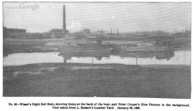
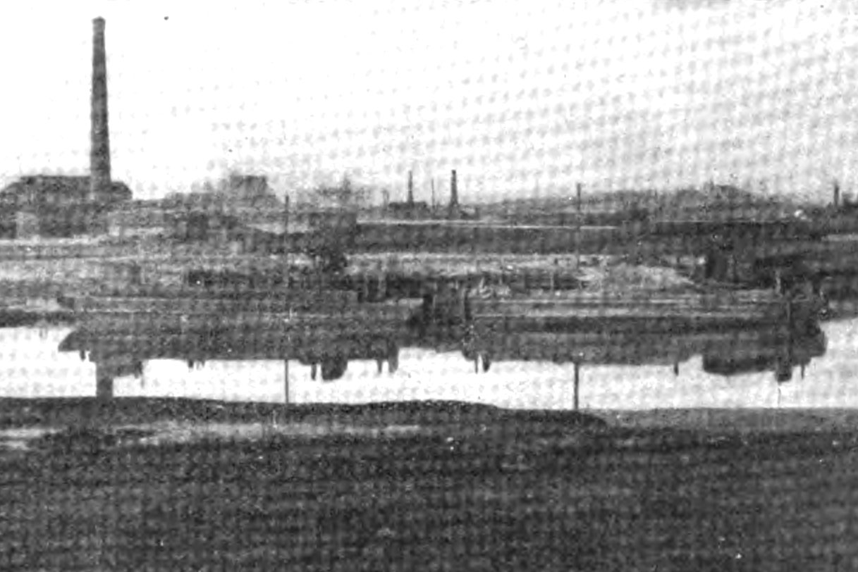
One of those little nuggets which has fascinated me since beginning to learn about the Creek has been references to “Conrad Wissel’s Dead Animal Wharf” or alternately “night soil dock”. Imagine my surprise when I found a photo of the place from 1896 the other night. In the far left corner of the frame, you can just make out the Maspeth Avenue Plank Road. Wo!
– photo from 1896’s Report By Brooklyn (New York, N.Y.). Dept. of Health, Brooklyn (New York, N.Y.). Health Board, courtesy google books
A little photoshopping has been applied here, improving contrast and attempting to remove some of the moire in google books’s scan of the original.
– map from 1896’s Report By Brooklyn (New York, N.Y.). Dept. of Health, Brooklyn (New York, N.Y.). Health Board, courtesy digitalgallery.nypl.org
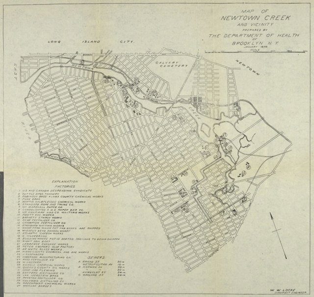
The NY Public Library hosts the image above, which is the map that was included in the volume that the photo originates in. Click the image to access a zoom able version, whose key lists the Wissel’s dock as number 16.
– map from 1896’s Report By Brooklyn (New York, N.Y.). Dept. of Health, Brooklyn (New York, N.Y.). Health Board, courtesy digitalgallery.nypl.org
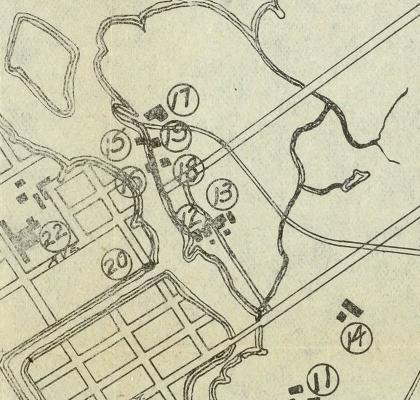
In this detail from the map, number 16 is clearly just west of the Maspeth Avenue Street end. That’s one mystery solved.

– photo by Mitch Waxman
Here’s another view in modern times, the Wissel property would be just starting on the right side of the frame. The shot is from the Queens side, of course, as is the original- and captured at approximately where the “18” is on the detail of the map. The 1896 photographer would have standing around 500 feet to the right of this vantage point.


