Archive for the ‘newtown creek’ Category
Flickr group
I use Flickr to share photos, and waste a lot of time there. After years of lurking and posting in various LIC and Astoria groups, its time to start the Newtown Pentacle Group. Quoted from the group page:
“The Newtown Pentacle is looking for unique points of view along the 3.5 mile long industrial waterway in New York City. Shots of victorian relicts, aging industrial neighborhoods, remnants of a historical site. Do not break the law. No pics of floating poop or prophylactics. Pics are even better if you’ve got a story to go with them.”
So far, its a little heavy on Old Mitch’s stuff, which I threw in just to get things started. Got a pic with a story or anecdote? Want to share? Do it at the Newtown Pentacle group- here
I’m serious about the “do not break the law” part, by the way. The creek is a dangerous place full of giant machines moving at full throttle and at high voltages. 911 is probably not an option on the wrong side of a fence when you’ve just crashed into a homeless camp or found out where the cement factories guard dogs live. A controversial post at citynoise not long ago showcased an urban explorer moving along the trackbeds along Dutch kills.
The photographer crossed active tracks- and such activities are both considered trespassing by the Police (in this case- Amtrack Federal Police), and are crazy dangerous. They were very nice shots and interesting perspectives on Dutch Kills- but- Break The Law at your own risk.
A tale of two cities… Long Island City part 2

Manhattan from Gantry Plaza Park- 3 exposure HDR photo by Mitch Waxman
In the period directly following the American Civil War, Manhattan became known not as a shining citadel- the Acropolis of business and finance– but as a crime riddled warren of dark and smokey alleyways infested with diseased immigrants which terminated in gangster controlled docks and warehouses at the edges of garbage strewn rivers.

Illustration from wikipedia
The Municipal Police were more accurately described as an officially sanctioned ethnic street gang (that wore blue coats with big brass buttons- colors!) who worked for the bourgeoisie uptown. The Fire Department(s) would fight each other over turf whilst whole blocks burned down. The political class profited from this chaos, and eventually a man named Tweed came to Tammany. This all started to change in the 20th century, of course, when progressives and reformers began to organize what would become the great metropolitan city. Whatever problems New York has in its latest incarnation, institutionally speaking, the time of the 19th century was very much “the bad old days”.

Illustration from wikipedia
Across the river from Manhattan, of course, was Brooklyn. A city of holy rollers, abolitionists and suffragettes in Park Slope and Brooklyn Heights, free thinkers and poets in Williamsburg and Carroll Gardens. The city was segregated into large ethnic enclaves, but within these enclaves– equanimity reigned. A rich Negro (archaic term Negro is used because that is the term used at the time, sorry to political modern newspeakers) or Irish man could, theoretically, build just as big a house in their parts of town as a rich white man could in his (depending on your relative definitions of rich, of course).
Negros and Catholics (irish, german, polish) were the oppressed minorities, and the remaining Dutch were seen as backward and quaint. Affluent, Brooklyn built churches and schools, and became a community of commuters moving back and forth from jobs in Manhattan by ferry. The Brooklyn Daily Eagle seemed to be aimed at a demographic I’d describe as “an anxious middle class saddled with an inferiority complex”.
Overly concerned with social standing, the Brooklynites of the late 19th century are the people who demanded that Prospect Park and the Champs d’Elysses of Brooklyn- Grand Army Plaza be built, and whose graves fill Green-wood Cemetery. Travel from the Brooklyn Bridge, moving up Flatbush avenue all the way to the Marine Park Bridge and witness the lowering gradation of building density as you travel away from Manhattan (a great bike ride!). This is Brooklyn.
View Flatbush Avenue to the Marine Park Bridge in a google map, use “streetview” for local knowledge
In accordance with its self defined status as “a city of homes“, the city of Brooklyn outlawed steam propuslion of rail traffic at grade level through its streets in 1851. The company affected by this was of course, the 800 pound gorilla itself. By 1859 the aldermen and ward bosses of Brooklyn ordered that the great ape cease using steam entirely, close the Cobble Hill tunnel, and provide horse carriage transport for both passengers and freight between Jamaica, Queens (where the gorilla had set up terminal operations) and points westward- including Manhattan. This would turn operating a freight route through Brooklyn, a logical terminus for shipping goods (mainly agricultural) from eastern Long Island, all the way to the factories and tenements of Manhattan’s lower east side, into a very expensive proposition. The 800 pound gorilla refused to comply. The bosses were desperate to find a place where they could lay all the track they wanted to, and where a compliant government would help, rather than hinder progress.

Rail overpass, Long island City- 3 exposure HDR Photo by Mitch Waxman
In 1859, the New York and Jamaica railroad was chartered, and then bought by the 800 pound gorilla in 1860. Service was driven through to Hunters Point, near the ferries that crossed the East River to Manhattan, or New York as it come to be known. The company abandoned its properties in Brooklyn, leasing right of way for itself on the few profitable destinations like the Atlantic Avenue stop and the Bay Ridge freight line. The 800 pound gorilla had arrived in what would soon be called Long Island City, but it couldn’t sleep anywhere it wanted to, not quite yet.

This is the actual trackbed! Hunter’s Point- 3 exposure HDR Photo by Mitch Waxman
The Ancient Seat of Graft, Part 2

Long Island City Courthouse, Long Island City– 3 exposure HDR Photo by Mitch Waxman
In the late 1860’s, Newtown Township was being run, politically, by a group of country hicks from eastern Long Island who wouldn’t know a good deal if it bit them on the bottom. All the sweat and blood being shed in Hunter’s Point, and along Newtown Creek- servicing the exploding populations of the two cities (Brooklyn and especially Manhattan)- it was the East River’s taxes that were building elaborate courthouses and paving roadways (in Jamaica, Queens and other unimaginably eastward points)- but what were these “New Men of industry” getting back from Newtown Township?
Was it those baronial Dutch farmers from Elmhurst who built the ironclad Monitors that redefined naval warfare? Was it they who had set up the casino riverboats, and a Turtle Bay to Hunters point ferry service to bring in the rubes, when Manhattan outlawed card rooms and horse betting parlors? Did those cloud watchers and pig farmers build the greatest and most productive shipyards in the entire world on Newtown Creek, or was it men like Cord Meyer and Daniel Pratt? The entrepreneurial explosion of the industrial revolution, the future, was happening right now on the East River and especially on the Newtown Creek, not Long Island Sound or Jamaica Bay.
These farmers from Flushing were standing in the way of progress, and holding on to an agrarian way of life that the railroad was obviously going to destroy. Besides, all the farm goods on Long Island would still have to go through the docks in Hunters Point and Astoria on their way to Manhattan anyway. The shores of Newtown Creek were bulkheaded and straightened by Newtown Township in 1868 in an effort to boost navigability.
In 1870- the leading men of the communities of Astoria, Ravenswood, Blissville, Sunnyside, Dutch Kills, Bowery Bay, and Middleton combined their considerable political patronage and their vast fortunes together and formed Long Island City. The population of the new city didn’t quite number 10,000, but the great unwashed- like we modern multitudes- were just along for the ride.
All this was far more than the men who owned and operated the 800 pound gorilla, also known as the Long Island Rail Road, could have asked for.
Industrialists and gangsters all over the new city vied for position on the train tracks, waiting for the iron road to lead the world directly to their door.
Get ready for 28 years of blood drinking, lip licking, mustache twirling, union breaking, environment destroying, slavering “capitalism running amok”-in our next installment.
Which will be sometime toward the end of this week, if not next week. Might be a couple of little posts as well. Lots going on.

Newtown Creek fuel depot, Blissville– photo by Mitch Waxman
Incidentally- 1870 is also the year that John D. Rockefeller founded Standard Oil. For those of you who are young-ins and unfamiliar with the original archetype for “American Villainy”, John D. was a real life combination of Mr. Potter from “its a wonderful life”, Mr. Burns from “the simpsons”, and Daniel Day Lewis’s character in “there will be blood“- and he made Dick Cheney look like a cuddly old man. Fifteen years after he started Standard, John D. Rockefeller was the dominant player- in North America- in the fields of railroads, natural gas production, oil drilling, oil refining, and copper refining. He created, and controlled what would become “Big Oil“.
His buying power and predatory instincts were such that he controlled the price of industrial commodities nation wide. His fortune was so large when he died that he is considered to have been the richest person in recorded history. In 1902 an audit showed his personal fortune was worth nearly 5% of the Gross Domestic Product of the United States. Standard Oil would eventually become known as Exxon, and the bank account grew into Chase Manhattan Bank. This is why Exxon is being compelled by the federal EPA to clean up the Greenpoint oil spill.
Standard Oil’s plant was one of the largest properties on the Newtown Creek. An explosion and fire at a Greenpoint Standard Oil refinery in 1919 consumed 20 acres and burned over 110 million gallons of oil.

Misty Day at Newtown Creek Petrochemical plant, Brooklyn Side- 3 exposure HDR photo by Mitch Waxman

Newtown Creek Rail Tracks, Long Island City- 3 exposure HDR photo by Mitch Waxman
As always, if something you read here is contradicted by something you know, please leave a comment or contact us. Corrections and additions are always welcome.
Some more shots from The Queensboro Centennial
Sorry, the 2nd part of “Long Island City” is on the way- its just a BIG subject, and I’ll be talking about a few things that need some CAREFUL researching. I’ll have it done fairly soon.
Here’s what I was doing on the 31st of May, 2009.

Long Island City From the Queensboro bridge, stitched panorama – Photo by Mitch Waxman
As I mentioned in an earlier post on the subject, the Bridge Centennial Commission asked me to help out on Dave Frieder’s walking tour of the Queensboro Bridge. Here’s some highlights- (check out the money HDR pic a few posts down, by the way). I mainly carried Dave’s camera bag and kept us moving to the podium on schedule.

Dave Frieder on the Queensboro bridge- Photo by Mitch Waxman
The tour I assisted with was led by Dave “the Bridge Man” Frieder. He is an ironman photographer who routinely and legally climbs the bridges of New York (and beyond) to take some of the most white knuckled (and gorgeously composed) photos you will ever see. check him out at www.davefrieder.com

The United States Merchant Marine Academy Marching Band- Photo by Mitch Waxman

Mayor Mike Bloomberg arrives- Photo by Mitch Waxman

Mayor Mike Bloomberg kibbitzes with “Gridlock” Sam Schwartz and DOT Commissioner Jeanette Sadik-Khan- Photo by Mitch Waxman

Mayor Mike Bloomberg kibbitzes with “Gridlock” Sam Schwartz and DOT Commissioner Jeanette Sadik-Khan- Photo by Mitch Waxman

Francesca Lindenthal Gebhardt, daughter of Gustav Lindenthal meets Mayor Mike Bloomberg- Photo by Mitch Waxman

Mayor Mike Bloomberg asks crowd “how are you feeling here on the Queensboro bridge?, says “I‘m feeling groovy“. Ceremonies begin- Photo by Mitch Waxman

Ceremonies, Queens Borough President Helen Marshall speaks- Photo by Mitch Waxman

One of the classic cars in the parade- Photo by Mitch Waxman

Determined and ready to ROCK- Photo by Mitch Waxman

Ceremonies, crowd and press watching- Photo by Mitch Waxman

Mayor Mike Bloomberg, “Gridlock” Sam Schwartz, DOT Commissioner Jeanette Sadik-Khan, Queens Borough President Helen Marshall, Manhattan Borough President Scott Stringer– Photo by Mitch Waxman

Crowd watches ceremony- Photo by Mitch Waxman

Marching band- Photo by Mitch Waxman
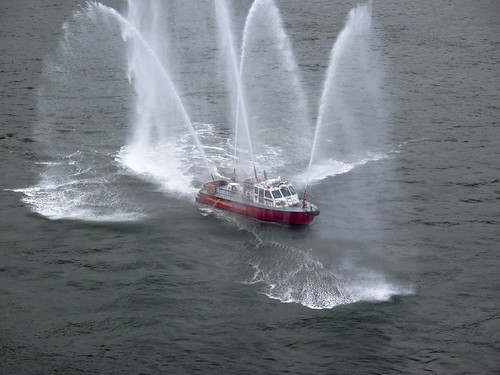
New York Fire Department Fireboat arrives and performs- Photo by Mitch Waxman

Parade ends, heading back to Queens, thinking about George Romero or maybe Lucio Fulci– Photo by Mitch Waxman

Up in the Steel- Photo by Mitch Waxman

Modern shiny Long Island City of the future from old crappy Long Island City of the past- Photo by Mitch Waxman

View from the Queens-bound ramp on the Queensboro bridge- Photo by Mitch Waxman

Another one of the classic cars in the parade- Photo by Mitch Waxman

View from the Queens-bound ramp on the Queensboro bridge- Stitched Panorama by Mitch Waxman

Sunset view from Ravenswood, from a roof party at the new Ravel Hotel- Photo by Mitch Waxman
“The Ancient Seat of Graft”, or Long Island City- part 1
Title quoted from “Building Gotham, by Keith D. Revell” here’s pp 134 in Google books

Manhole cover on Jackson Ave.- photo by Mitch Waxman
Neo-Pragmatist musings:
Modernity causes us to look upon the sometimes sleazy relationships between our political class and the real estate and banking interests they do business with as something new, untempered, and unique. This is the hazard of our times, a lack of institutional memory and insight. This lack of pragmatic introspection has resulted in widespread voter apathy, which in turn has caused the political class to seek support from those who will give it to them. Only when the citizenry at large comes to the polls in great numbers do the politicians realize with whom their constituency lies.
Previous generations, in their attempt to reinterpret the past and govern in the present through say… fashionable political lensing, have obscured many of these pragmatic realities of governance. There will always be a “mafia”, the rich will inevitably victimize the poor, industries will destroy the neighborhoods they define. No bill or proclamation can make these forces disappear, and in the defense of our “Politik’s”, you must admit that modernity compares quite favorably against the past here in our Newtown Pentacle, when the subjects of good government and civic minded progress are invoked. For those of you who live in the Pentacle… let that thought… just… settle in.

Newtown Creek from Hunter’s Point Avenue Bridge- photo by Mitch Waxman
The short history of Long Island City is hair curling, graft and corruption wise. It’s an american story about a boom town run by industrialists, bankers, and railroads situated at the border confluence of two other, far larger- far richer, boom towns- Breuklyn, and New Amsterdam.

LIRR Wheelspur yard, taken from Pulaski bridge fencehole– photo by Mitch Waxman
Native New Yorkers and the Knickerbockers:
The Mespaecthe or Mispat were part of the Rockaway (Rechaweye or Rechqaakie) Chieftanate. Their “village” was in Dutch Kills near the modern Borden Ave. They called the area between vanished Sunswick Creek and Newtown Creek “Hohosboco”. The Rockaway’s were part of a larger tribal/national/ethnic group- the Metoac. The Metoac were the “Thirteen tribes of Long Island”, and included the Jameco, the Manhattan (island people), and the Sewankie (the sea people). By 1630, the Metoac, whose territories were bordered by the Lenapi (Delaware) and Algonquin nations, had fallen under the control of a Delaware martial tribe called the Pequot. The Pequot forced the Metoac to manufacture tribute, Wampum, which in turn bought the Pequot and the larger Delaware Nation better terms in their dealings with the Dutch fur trade. This was New York City’s first speculative financial bubble, and it collapsed in 1655.
In the 1640’s, the first Dutch settlers had crossed into the “Mespit” (or head of the stream) and settled a strip of land they called Dominie’s Hook (land was granted to the Rev. Everard Bogardus in 1642 for the establishment of a dutch reform church). The Mespit was, of course, the Newtown Creek. A colony was established in 1642 called “Maspat” (which is a Mespaecthe word meaning Bad Water) near modern day Maspeth. The first European settlement in Queens, the europeans proved themselves to be such a nuisance that the village was attacked in force by the Mespaecthe and the settlers fled to the fortified island of Manhattan for safety.
In 1647, Rev. Bogardus died in a shipwreck, and his wife inherited the property. The Dutch began building watchtowers and stationing troops throughout the Newtown Pentacle in an effort to cut down on raids by the aboriginal population. By 1655, the Mespaecthe had realized the error of allowing a foothold for the Europeans and after a British/Mohican alliance effectively ended the ambitions of their overlords- the Pequot, they began a campaign to regain their ancestral lands.
In 1655, smallpox came to the Mespaecthe. By 1666, the year of London’s great fire, there were only 500 Mespaecthe left. In 1788, there were only 162. In 1833, the remaining Mespaecthe were christian converts (of the Mohegan sect) and a great many of them joined with Samson Occam and left New York to become part of the Brothertown Indians. They migrated to Lake Winnebago in Wisconsin, leaving the Newtown Creek for the europeans. The story gets a little hazy around this point, as these people were the focus of a genocide- but those who stayed in the area mostly migrated to the eastern tip of Long Island and assimilated into the Matinecock and Shinnecock tribes in the area of Montauk Point. Largely, they became whalers and sailors in the early 19th century, and inter-married with other tribes.
In 1697, a Dutch sea captain named Peter Praa bought the Bogardus properties and set up farming. He died in 1740, and the land was left to his granddaughter Anne Bennet. Her son, Jacob Diks, inherited next and he passed the land to his daughter- Anna Hunter. In 1817, Hunter, who had three sons, left the land to her children under the proviso that it be sold and the moneys divided evenly between them. This is why the “Mispat” became known as “Hunter’s Point”.

Hunters Point from Newtown Creek– photo by Mitch Waxman
interesting note: The modern city is in the early stages of replacing the Kosciusko Bridge, which carries traffic over the Newtown Creek. Descendants of the Matinecock and Canarsee tribes have emerged, and are unhappy about further degradation of their ancestral lands. “A lot of people think we are extinct, but we have many who are still left”.

Queens Museum of Art- Worlds Fair Panorama, Long Island City and Greenpoint at center- photo by Mitch Waxman
This week, hopefully, I’ll have the rest of the story ready. Get ready for Battle Ax Gleason, Wilhelm Steinweg, the German Socialists of Schuetzen Park, and the arrival of Long Island City’s 800 pound gorilla and raison d’etre- the Long Island Rail Road. A few smaller posts coming in the next couple of days for sure, but I have some double checking of factoids to do before I publish.

Long Island Railroad crossing Borden Avenue at grade– photo by Mitch Waxman
As is always the case, if anything you’ve read here is contradicted by something you know, leave a comment and let’s talk about it.
The Cemetery Belt

Visible from space, the Cemetery Belt is contained entirely within the Newtown Pentacle – First Calvary, Second Calvary, Cypress Hill’s, St. Michael’s, Mt. Olivet, and Mount Zion represent the interments of tens of millions of New Yorkers. Three million lie in new Calvary alone. The estimated number of those at rest is triple the live population of Queens.
The vast majority of these graves were laid down in the first half of the 20th century. The names on the headstones are the names of forgotten celebrities, politicians, mobsters and molls. The movers and shakers of their time, many had elaborate mausoleums and tomb markers built for themselves- but the vast majority of those who lie here were ordinary people. Old Calvary in particular is home to some of the most interesting stone work in the entire city. However, like much of the Newtown Pentacle, respect for the dead didn’t hinder Robert Moses from pushing through.

this is a stitched panorama- check out the huge original at flickr. (click “all sizes”) The funeral scene in “the Godfather” was filmed at Old Calvary for instance, not too far from the spot pictured above.


The vast Necropolis was built in response to deadly outbreaks of cholera in Manhattan’s tenements in the 1830’s and 40’s. At the time, cemeteries were all over the place- including back yard plots and storefront church cellars, and the belief amongst the body politic was that these bodies were poisoning the ground water and causing the cholera. Thus, a proclamation (the Rural Cemeteries act of 1847) that no new cemeteries would be allowed in Manhattan was announced, and the creation of the Cemetery Belt began. What’s more, between 1854 and 1856- the exhumation, transport, and reinterment of nearly 15,000 bodies from Manhattan to Queens was accomplished. Here’s an article from newsday about it.

Death was and is big business, and Long Island City was and is all about business. Ferry service ran from Manhattan and Brooklyn bringing the bereaved up Newtown Creek to the New Calvary Pier in Blissville.
The Long Island Railroad maintained a station at Penny Bridge carrying mourners from all points east. Funeral processions involved marching bands and extensive paegentry. A trip to the graveyard was like visiting a sculpture park for the whole family, with exquisite landscaping and an arboretum of exotic trees and flowering plants sprouting from a grassy hill. Clothes were crisply laundered in boiling water (using lye as a detergent), children ordered to behave or else . What a change, if only for a few hours, from the gaslit darkness of Manhattan’s tenement alleys. A beautiful day with the family, spent at the Newtown Creek.


Quoting from James Riker Jr.’s “Annals of Newtown”, here’s how the area around Calvary came to be called Laurel Hill. from Brooklyn Genealogy

This village is located in the extreme northwestern corner of the town of Newtown and is separated from Brooklyn by Newtown Creek, which is spanned at this point by the old “Penny Bridge” built in 1836. A large portion of the land included in the village plan was formerly a part of the Alsop property. Here was the home of the Alsop family- a family now extinct in Newtown, although for more than two centuries they were among the most prominent residents of the town. Edward Waters once owned a farm here of a hundred acres, which he sold in 1852 to Jacob Rapelye. Augustus Rapelye, his son, became owner of seven or eight hundred acres of land here, and in 1853 laid out the first village lots. His map is known as “the four hundred lots.” George W. Edwards in 1845 bought a portion of the Alsop property, and subsequently that was laid out into building lots. The laboring people, who compose a large part of the population of the village, are principally employed in Calvary Cemetery, located here, and in the marble works in the immediate vicinity. In 1858 Henry Schafer established his cabinet manufactory here, and for several years manufactured a general line of cabinet ware; but for the last ten or twelve years he has made a specialty of children’s cribs and cradles, in which he and his sons are doing a business of considerable proportions. The shirt manufactory of Edward H. Inglis furnishes employment for twenty or thirty female operators. A post-office was established here in the summer of 1881, with James Duffy as postmaster .
THE LAUREL HILL CHEMICAL WORKS. These works were established in 1866, by C.W. Walter and A. Baumgarten, but remained comparatively small for several years. In 1871 G.H. Nichols and W.H. Nichols entered the firm, and A. Baumgarten retired. In 1872 their first oil of vitriol works were erected. The acid gave such satisfaction that increased manufacturing facilities were required, and one factory after another was erected, until now the works comprise the largest plant for the manufacture of oil of vitriol in the United States. Muriatic, nitric and other acids are made in quantity, as well as Paris white and whiting. The proprietors have recently purchased a copper pyrites mine in Canada, and intend taking the ores to Laurel Hill, extracting the sulphur in the manufacture of oil of vitriol, and smelting the copper in works about to be erected. In May 1875 Mr. Walter and his family were lost on the “Schiller,” and the works have since been the exclusive property of G.H. Nichols & Co., and are only one of several enterprises in which they are engaged. The superintendent of the chemical works is J.B.F. Herreshoff; of the whiting warks, E.V. Crandall. The analyist is Lucius Pitkin. The buildings shown in the illustration, where the business is now conducted, have all been erected by the present proprietors, the first plant erected by Walter & Baumgarten having been entirely removed. The present buildings cover one block, 200 by 300 feet on one side of the railroad and on the other side 200 by 240 feet, with a dock frontage on the creek of about 400 feet. The capacity of the works at present is the production daily of about 600 carboys of oil of vitrol, besides muriatic and nitric acid made from sulphuric acid as a base. The whiting works produce about 10,000 bbls. annually. Forty thousand pounds of sulphur is burned daily in cold weather, but less during the summer months. The business employs from sixty to seventy-five men steadily. The manufacturers are redeeming several lots now under water, and contemplate a new dock on the creek, to cost from $5,000 to $6,000, on which they are to erect copper furnaces for smelting ore. CALVARY CEMETERY. This cemetery, which is located at Laurel Hill, was set apart and consecrated in 1848. It is one of the most accessible rural cemeteries near New York, and it would be difficult to select a lovelier or fitter spot as a place of sepulture. The old ground comprised one hundred and ten acres, but in 1853 a charter was obtained from the State by the trustees of St. Patrick’s cathedral, New York city, for 250 acres; 165 acres of this are now enclosed. The artesian well in that part of the enclosure called New Calvary was sunk in 1879. It is 606 feet deep and 6 3/4 inches in diameter, and was bored in white granite for a large part of its depth. Last year 32,000 persons died in the city of New York, and of this number 15,500 were buried in Calvary. The cemetery keeps one hundred and fifty men regularly employed, and two hundred more are kept at work by the relatives and friends of the deceased. Here may be found some of the choicest of materials and the finest models in monumental structure; and here we may mention as worthy of note the vault and chapel built by John Johnston, at a cost of $75,000, and regarded as one of the finest to be found in any ground. This cemetery is to the Catholics of New York what Greenwood is to the Protestant population. Since 1872 Hugh Moore has been the general superintendent, and to his ability much of the beauty and attractiveness of the place is due; he has been assisted by Michael Rowen. The mortuary chapel, of fine architectural design and finish, was built in 1856. The present chaplain is Rev. M.J. Brennan.


