Archive for the ‘Pickman’ Category
nothing unprecedented
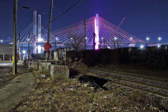
Just another day in paradise, yo.

– photo by Mitch Waxman
The sculptor who designed the plastic pink lawn flamingo was Donald Featherstone, a task he accomplished in 1957 for a company he ended up running until his retirement in 2000 A.D., called Union Products Inc. I had a dream once where Featherstone’s Flamingoes were chasing me and fell out of bed. Sleepwalking, or somnambulism, is quite rare and only regularly affects about 4% of adult humans. Sleepwalking episodes typically last anywhere from thirty seconds to thirty minutes, and there are sleepwalkers who have actually left their homes for a sleep drive in their cars while dreaming. There are sleep eaters, and sleep “shtuppers” who engage in sexual coitus (sexsomnia) while totally asleep. There are several legal proceedings in which a sleepwalker has actually murdered someone, wherein the somnambulist was pronounced not guilty. That’s a slippery slope.
As a child, I became convinced that quicksand, which is a fascinating soil condition caused by a particular ratio of sand and water that forms a “shear thinning non Newtownian fluid” was something you needed to be prepared for as an adult. Stress the sand/water mix – say by stepping on it – and the sand and liquid will seperate and you’ll sink right in. The physics of it all are fascinating, and removing yourself from the quicksand is difficult and complicated. Trying to just pull yourself straight out would require titanic amounts of force. Your best bet, I’m told, is to slowly work your self into a position where you’re facing the sky and your limbs are spread out as far as you can manage (which is the same advice offered for those caught in avalanches of snow). Then you sort of wiggle and wriggle your body towards the solid ground direction that you came from. Contrary to popular belief, due to the relative material density of the quicksand and of your body, you likely won’t sink in past your waste even if you do panic and struggle. Those who die in quicksand do so due to hypothermia and or the arrival of carnivores. I don’t know if Flamingoes qualify as carnivores, and don’t want to find out.
As a note, quicksand has not turned out to be the ubiquitous problem when “adulting” that I thought it would be.

– photo by Mitch Waxman
It’s likely that you’ve experienced, when laying down to sleep, feeling your arms or legs suddenly twitch or jerk for no reason. That’s called a hypnic or “myoclonic jerk” by sleep specialists. It’s pretty normal, but the league of doctors aren’t of a single mind as to causation for the phenomena. On the other side of things, that period of 15-30 minutes when you first wake up and are experiencing both cognitive difficulty and motor skill impairment is called “Sleep Inertia.” Part of ir is caused by the presence of a certain chemical, and you’ve got a series of receptor cells in your brain for this chemical called “Adenosine,” which is abundant in the noodle when you’re sleep deprived – which most of us are. Caffeine is a blocker for these Adenosine receptors, and that’s why if you haven’t had enough sleep a “cuppa Joe” will help snap you out of the sleep inertia. Saying that, it’s still pretty normal to be a bit groggy when you wake up, since your body has been in an anabolic state and busy cleaning up the mess you made of it the day before. The natural process of waking up involves a spike in cortisol levels in your blood, wherein the adrenal glands can manufacture an average of more than fifty percent more cortisol than when asleep. Ultimately, Cortisol levels are the difference between “morning people” and “evening people,” which is thought to be related to individual “cortisol awakening response.”
A humble narrator has always been the latter, a “night owl” as it’s called. I’ve never been a Flamingo.

– photo by Mitch Waxman
The section of the East River pictured above varies in depth from about twenty five to fifty one feet, which you can visualize by thinking about submerging a series of buildings which range from two to five stories. If the Empire State Building ever found itself sitting in the middle of the East River, and hey… climate change, amiright?… it would still rise some ninety seven to one hundred stories into the sky. A couple of years ago, somebody asked me to do a boat tour of shipwrecks in New York Harbor, but it seems that wrecks are cleared out in an expeditious fashion as they’d otherwise be a hazard to navigation and commerce. So, I believe, are flamingoes.
Hope you enjoyed today’s completely random trivia, back on Monday with something completely different, at this – your Newtown Pentacle.
“follow” me on Twitter- @newtownpentacle
less than
Another day, another bridge across Newtown Creek.

– photo by Mitch Waxman
There are five bridges crossing the Dutch Kills tributary of that lugubrious ribbon of urban delight called the Newtown Creek, here in Long Island City. You’ve got two movable railroad bridges, the retractile Borden Avenue Bridge, the high flying truss which carries the Long Island Expressway and then slopes down into the Queens Midtown Tunnel, and the good old Hunters Point Avenue Bridge. There’s been a bridge of one kind or another here since about ten to twenty years after the Civil War, with one notable span made of wood whose opening and closing was powered by ropes and a donkey. The current bridge was installed in 1910, when Michael Degnon was building his industrial terminal around Dutch Kills, and the Pennsylvania Railroad was finishing up their construction of the Sunnyside Yards.The Hunters Point Avenue Bridge was originally a double bascule drawbridge, but back in the 1980’s, the City rebuilt the roadway and replaced the mechanism with a single bascule version, which is the one featured in today’s post.
Apparently, Hurricane Sandy did quite a job in the electrical equipment that operates the thing, and since the City is required by the United States Coast Guard to maintain the HPA Bridge as a movable structure there’s been folks working “down below” in the gears and gizmos of the thing. It’s on one of my main routes when I’m out for a walk.

– photo by Mitch Waxman
The other night, Dutch Kills was frozen into a giant plate of ice. This isn’t surprising, since the hydrology of the canal displays very little in the way of laminar or horizontal flow. The water rises and falls with the tide, obviously, but the shapes and angles of the bulkheads in addition to zero sources of flowing water at its terminus other than a couple of open sewers cause the waters of Dutch Kills to mimic the behaviors of a stagnant lake rather than a flowing creek.
A few years ago, I started reading up on hydrology and talked to some of the powers that be about using “shaped” concrete forms to cause zones of compression and expansion which would passively move the water around a bit, but nothing really came of it. I still think this sort of engineering is the way to go, however. As I understand the concept, rounded shapes act as “brakes” in fluid systems, whereas narrowing the width and obliquing the angle of channel walls causes water to flow (think river rapids). Essentially, large bodies of water can’t rise that much above the level of surrounding water bodies they’re connected to, so when the volume hits a point of compression it gets “squeezed” and pressurized which causes it to begin moving towards a point where it can expand again. As an example, the same water pressure in your kitchen faucet is what feeds into your garden hose, with the only difference between the wildly dissimilar behavior of the same water pressure being that the stuff in the hose has been compressed all the way through the nozzle and the sink faucet flow can just expand into the basin.
Design in enough points of compression and expansion, you’ve got “flow.” Or at least, that’s my theory. What do I know, I’m a schmuck with a camera, not an engineer.

– photo by Mitch Waxman
Another hypothesis I can offer is that the Newtown Creek is far more biologically active at night than it is during the daytime. All the time I’ve spent around the waterway in the last year at night has revealed an otherwise hidden world that comes out in the dark. There’s higher mammals, both feral cats and raccoons, which are occupying the predator and scavenger niches. You can see and hear vast numbers of fish splashing around in the water, and there’s all sorts of critters crashing around at the littoral edges and along the bulkheads.
The shots in today’s post were exposures of about thirty seconds, so you won’t see what I saw when shooting them unless it held stock still for that interval of time. What I saw was a big fat raccoon foraging around at the water’s edge, scooping up shell fish and other horrible wriggly things to eat for dinner. Actually, it was probably for breakfast, as the trash pandas are nocturnal – just like me.
“follow” me on Twitter- @newtownpentacle
hoarsely explained
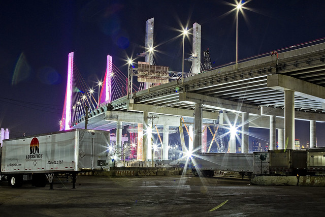
Checking in on the Kosciuszko Bridge project.
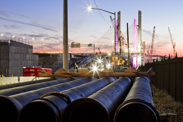
– photo by Mitch Waxman
Recent endeavor has found me wandering around the fencelines of the Kosciuszko Bridge project site again, and causing their security guys all sorts of worry. As always and as a rule, one does not trespass, preferring instead the peripheries.
The second phase of the construction project began shortly after clearing the rubble left behind by the “energetic felling” of the 1939 era Kosciuszko Bridge, and this is the first post of 2019 that delves deeply into the subject.
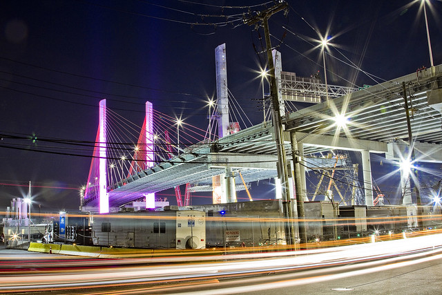
– photo by Mitch Waxman
The overpasses carrying the Brooklyn Queens Expressway over the streets of Maspeth are nearing completion, and the crews from NYS DOT’s contractor – Granite – seem to be heavily involved with installation of various sorts of pipe. Some of these pipes will presumptively carry water down and away from the roadway, while others will be conduits for electrical cabling, or at least that’s what it looks like to this layman’s eyes.
There’s still all sorts of disruption to the local street traffic occurring here on the border between LIC’s Blissville and Industrial Maspeth. That’s the intersection of Laurel Hill Blvd. and 54th avenue, for the morbidly curious amongst you.
– photo by Mitch Waxman
Documenting this project has been a long standing project of mine – this 2012 post tells you everything you could want to know about Robert Moses, Fiorella LaGuardia, and the origins of the 1939 model Kosciuszcko Bridge. Just before construction started, I swept through both the Brooklyn and Queens sides of Newtown Creek in the area I call “DUKBO” – Down Under the Kosciuszcko Bridge Onramp. Here’s a 2014 post, and another, showing what things used to look like on the Brooklyn side, and one dating back to 2010, and from 2012 discussing the Queens side – this. Construction started, and this 2014 post offers a look at things. There’s shots from the water of Newtown Creek, in this June 2015 post, and in this September 2015 post, which shows the bridge support towers rising. Additionally, this post from March of 2016 detailed the action on the Queens side. Most recently, here’s one from May of 2016, and one from June of the same year. Here’s one from August of 2016, the December 2016 one, one from March of 2017 which discusses the demolition of the 1939 bridge.
Here’s a post showing what I saw during a pre opening walk through in early April of 2017, and the fanfare surrounding the opening of half of the new bridge in April of 2017, a walk through of the Brooklyn side job site in June of 2017. Here’s some night shots from early July of 2017. A series of posts focused in on the removal of the central truss of the 1939 bridge from the summer of 2017 – a timelapse, some stills, and the barging out of the truss.
More recently, in late September of 2017, a final series of shots of the old bridge were captured in this post. Acquisition of a souvenir chunk of steel from the 1939 bridge was described in this post, and a video of the “energetic felling” of the approaches on October 1st was offered in this one. Still shots and views of the aftermath from the waters of Newtown Creek from later in the day on Oct. 1 are found in this posting, and the aftermath of the demolition as seen from Calvary Cemetery in LIC’s Blissville section in this post from October 5th. This post from December of 2017 closed out an event filled year in DUKBO, and a visit to the site at night is described in this March of 2018 post. Another progress report was offered in June of 2018. A nocturnal visit occurred in December of 2018, and here’s a short post from January of 2019.
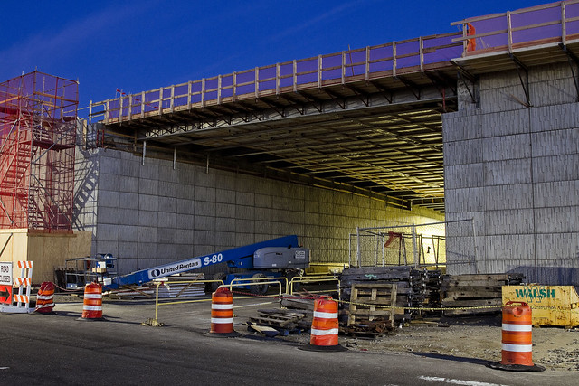
– photo by Mitch Waxman
Over on 43rd street, the first phase of the project which has been carrying traffic since April of 2017 is visible, with the two new concrete towers of the second phase also in sight. The first phase towers (which are in Brooklyn) are the ones that are garishly lit with cartoonish LED lighting, and the unlit ones are the second phase which are anchored into Queens.
– photo by Mitch Waxman
43rd street remains a barren industrial path, populated by heavy trucking, warehousing, welding supply, and crane companies. Set into a severe incline, 43rd street crosses Maspeth’s 56th road (which is called Review Avenue on the LIC side of the Bridge project) and continues southward towards the former premises of the Phelps Dodge company towards Newtown Creek. There’s an “at grade” rail crossing at its end, and a street called 57th avenue which is occasionally referred to as “Galasso Place.”
There’s a huge FedEx shipping hub down there, and the Restaurant Depot company, both of which sit on former Phelps Dodge properties.
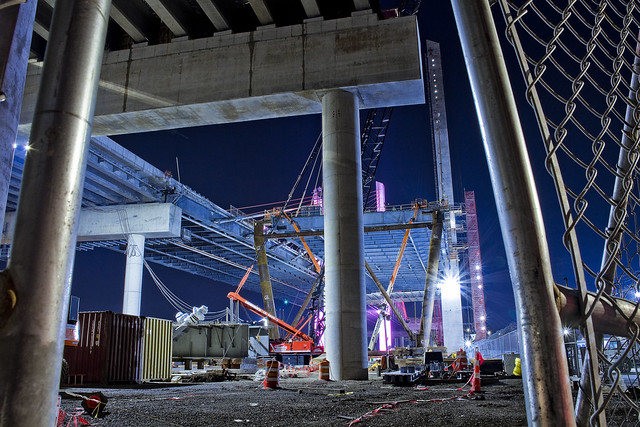
– photo by Mitch Waxman
A main thoroughfare for industrial traffic, 56th road is one of those fairly terrifying street crossings you find around Newtown Creek which was definitely designed with little thought to pedestrians. As is my habit in areas like this, and particularly at night, a high visibility “safety vest” is pulled over the shoulders of my filthy black raincoat.
Given the amount of night shooting I’ve been doing over the last year, that vest has become a standard part of my camera bag kit.
– photo by Mitch Waxman
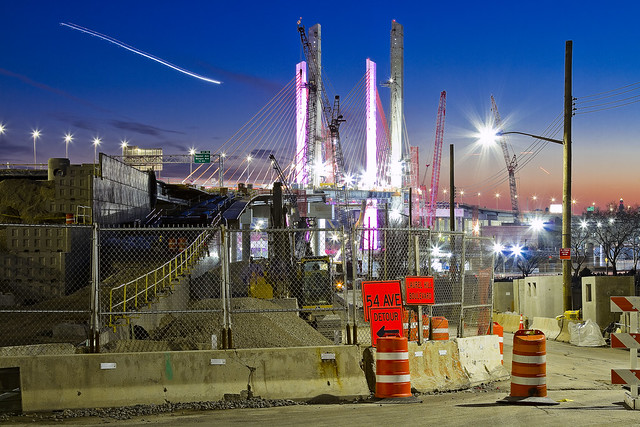
Looking through the fences at the heart of the project, southwards towards Brooklyn, from Review Avenue/56th road.
Intentionally, I went down to the site on a Sunday night when no work was going on so as to not get in the way. While you were watching the Super Bowl, I was shooting this.
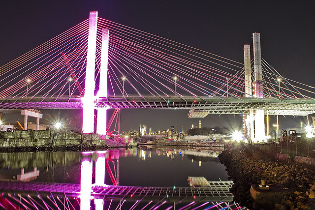
– photo by Mitch Waxman
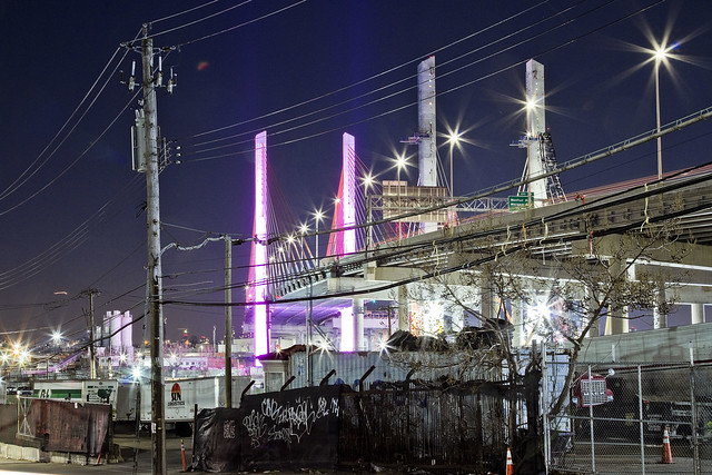
From the waterfront of Newtown Creek, looking westwards towards Manhattan, whose skyline you can just see peeking out behind Blissville’s Calvary Cemetery. The Brooklyn side is on the left, is nearby the tail or northern end of Meeker Avenue. I call both areas “DUKBO” or Down Under the Kosciuszcko Bridge Onramp.
– photo by Mitch Waxman
Looking eastwards from Review Avenue in LIC’s Blissville section, along the Lower Montauk tracks of the Long Island Rail Road. According to people in the know whom I’ve asked, the new bridge is due to open in either Q2 or early Q3 of this year. It all depends on the severity of winter weather.
“follow” me on Twitter- @newtownpentacle
spreading crypts
The other way!

– photo by Mitch Waxman
Pictured above is the newly reopened Broadway stop on the Astoria line N/W elevated. I spent all week describing a walk heading northwards along 31st street towards Astoria Blvd., so I decided to do one today describing the walk southwards from Broadway towards Northern Blvd., just in the name of completeness. The station has been rebuilt and reimagined, as one of the new “Enhanced Stations,” by Governor Cuomo, who does and does not run the MTA with an iron fist. It’s the Dark Prince of Albany who decides on when and if he’s in charge, so ask him if today is one of those days.
The enhanced stations bring some amenities to the table like station wifi and new security cameras, and Broadway in particular has seen a new exit only stair way (no fare control) installed which really has been a game changer in terms of expediting exiting of the facility. The big change, most noticeable from the street, has been the amount of new lighting systems installed, which has really altered the “feel” of the corner.

– photo by Mitch Waxman
Most of the 31st street corridor lives in perennial and centuried shadow, and even during the day, it’s dark. The street lamps are generally miniatures, with smaller than normal luminaire heads sitting on midget sized poles directly over the parking lane except at the intersections. There’s no lighting system in the middle of the street, suspended from the trackage, which lends an ominous “noir” to 31st street.
Personally speaking, given my proclivity towards darkness and skillful street camouflage born of living in 1980’s NYC, such lack of ambience holds no terror. Were I a lady or looked like I had money in my pockets, however, I’d likely be clutching my pearls while walking down this street given the lack of street life and darkness.

– photo by Mitch Waxman
The lighting schemes of the new stations spurt ambience all over the place. That’s the 36th avenue stop in the shot above, if you’re curious. It’s one of the “angles between neighborhoods” spots here in Western Queens, with LIC’s Dutch Kills and Ravenswood neighborhoods found to the south and west of 31st street and the “Astoria/Not Astoria” triangular shaped neighborhood between 34th avenue and Northern Blvd. to the east and slightly north. It’s also one of those interesting spots in Queens where you’ve got a soft geographic boundary between two wildly different ethnic populations, mostly Pakistani and extremely religious Muslims to the west and Brazilians to the east. There’s lots of other people mixed in there, of course, but dominant population groupings are what makes a neighborhood distinctive.

– photo by Mitch Waxman
The remnants of “mixed use” industrial zoning can be observed on the dark parts of 31st street as you proceed south, but these buildings and businesses are doomed by the aspirations of the affordable housing crowd and the Real Estate Industrial Complex. It’s already started, there’s more than a few of these old warehouse and factory buildings which have been demolished to make way for cookie cutter glass box residential buildings. In the distance, you can see the high rise residential buildings of Queens Plaza and “next big thing LIC” rising alongside the boundaries of the Sunnyside Yards.

– photo by Mitch Waxman
Nearing 39th avenue, where another of the enhanced stations is nearing completion, and the luminance of said station making a real difference in the “feel” of the street. Across the street from where this shot was taken is a Coptic Christian church and pastorate house which serves a mostly Egyptian community, or so I’m told. A large group of apparnetly Egyptian men were gathered in front of a new Dunkin Donuts on the corner of 39th, drinking take away coffee in paper cups and smoking cigarettes while debating something in their native tongue.
It was growing colder by the minute, and I decided it was time to start winding up my “constitutional” and head back home to Broadway in the 40’s via Northern Blvd.

– photo by Mitch Waxman
Progress? One still wonders about the lack of street life, storefront businesses, and ambient light on 31st street. It’s a traffic thoroughfare ultimately – 31st street – connecting Queens Plaza with the Grand Central Parkway and Triborough Bridge in its 20th century incarnation. There are, in fact, homes and businesses along its route, but personally I wouldn’t want to live along it. One thing I haven’t mentioned, whether in this series of posts or the ones from a couple of weeks ago describing Roosevelt Avenue and the streets of the Flushing Line corridor, is noise. Train noise, specifically.
Famously, I’m always listening to something on my headphones while out on my little jaunts, and when the train is passing overhead the noise overwhelms the speakers which are plugged directly into my ears. Can’t imagine what it’s like living next to those tracks, it must be hellacious.
“follow” me on Twitter- @newtownpentacle
popular opinions
Darkness and cold, it’s all darkness and cold.

– photo by Mitch Waxman
So far this week we’ve established a few things – the physical dimensions of a size 18 EEEEEE male foot, that Astoria’s 31st street used to be call Debevoise Avenue prior to the 20th century, and the convoluted and confusing history of the Astoria line elevated tracks which have defined the street since at least February of 1917 (I have no idea when construction on the “El” began, whether in 1915 or 1916 or whenever) have been explored. My “constitutional” stroll, which is how I refer to a short 90 minute walk “around” the neighborhood, found me turning north on 31st street and heading towards Astoria Blvd. from Broadway.
Along my way, I kept on wondering why it is that for the last century or so seemingly everybody over in Manhattan who has had a bright idea about how to “fix” Queens has been handed de facto Carte Blanche to explore and build their scheme. You don’t find a “Utopia Parkway” in other boroughs.

– photo by Mitch Waxman
From a city planning perspective, Astoria Blvd. can easily be analogized as a “municipal sacrifice zone.” First, however, I have to state my perception of Astoria itself being composed of three distinct neighborhoods. Two of them are divided by Astoria Blvd., with the commercial strips of 30th Avenue and Broadway defining the southern one, and the commercial strip along Ditmars Blvd. defining the northern one. The remaining section is defined by and found west of Crescent Street. Again, that’s my perception, and unfortunately the Real Estate Industrial Complex is constantly trying to redefine the ancient village with names like “Eastoria,” “Westoria” and so on. Sigh.
In 1922, a group of Queens based planners proposed the creation of a “scenic drive” which would start at Astoria’s East River waterfront, travel along Astoria Blvd., and hug the northern shoreline of the borough all the way east to the Nassau County line. Robert Moses liked that idea, and especially so when he began working on the Triborough Bridge. The first nine miles of the Grand Central Parkway, between Kew Gardens and Glen Oaks, opened in 1933. Moses has to find a way to pay for and build what he called “the missing link,” however. The missing link would connect Long Island’s Nassau County to his bridge.

– photo by Mitch Waxman
July 11th of 1936 is the day that the Triborough Bridge opened for traffic. Moses made a deal with the Federal Public Works Administration allowing him to spend $44 million – that they allocated for the approach roads to the bridge complex – to construct the seven and a half mile long “missing link.” The Grand Central was dug into a trench through Astoria, coming back up to the surface at East Elmhurst, where it runs to Flushing on a shoreline extension into Flushing Bay composed of landfill sand (which Moses brought in from his various beach projects in Rockaway). The parkway has been widened and deepened multiple times in the eight decades since, but the blighting divisions in Astoria have remained constant.
Last time I checked, some 180,000 vehicles a day exit and enter the Triborough Bridge complex via the Grand Central Parkway. As a note, the reason it’s called a “parkway” as opposed to a highway or expressway is because the shoulders of the road are planted. Once upon a time, there were apparently pedestrian pathways in those planted shoulders.
“follow” me on Twitter- @newtownpentacle


