There and back again
Thursday

– photo by Mitch Waxman
That’s the Birmingham Bridge which a tugboat is navigating up the Monongahela River under, here in Pittsburgh. Where the bridge comes back to land on the southern shore, seen on the right hand side of the shot, is where my car was parked. Due to construction, my original plan to walk across Birmingham Bridge was thwarted, and also due to that project a humble narrator was forced to just keep on going in a generally westwards direction until a river crossing manifested itself. This is from the northern shoreline of the waterbody, and I needed to get to the south side and then back to my waiting automobile.
That’s the quandary. I solved it by doing what I do, which to just keep on walking. Scuttling, actually, but let’s call it walking. Luckily, an apparently quite energetic young woman jogged past me, hopping a couple of feet into the air with every stride, and since she seemed to know where she was going I kept an eye on her path.

– photo by Mitch Waxman
The path which that fitness enthusiast blazed led me directly to the South Tenth Street Bridge, which I’ve actually mentioned before. The bridge connects several levels of the north side area together, including leading up to Duquesne University via a very steep staircase set against a bluff. There’s also a vehicle only tunnel punched through the base of the bluff which leads out to local streets. On the river facing side, you can navigate down to the waterfront and it’s trails, as well as to ‘for pay’ parking lots surrounding several governmental buildings. On the other side of the river, the bridge enters the South Side Flats neighborhood. That’s where I needed to go, to find my way back to the car.
Luckily, protected pedestrian and bike paths on bridges are pretty common hereabouts. One hung a left, and away a humble narrator went.

– photo by Mitch Waxman
It was a pretty pleasant walking experience, actually. Separated from vehicular flow by steel girders, but few chain link sections of fencing. One of my most sincere complaints about NYC DOT’s Bridge operations revolves around the prison yard fencing that they throw up everywhere they can. One of my proudest moments along Newtown Creek was convincing the NYS DOT not to chain link the new Kosciuszcko Bridge and instead install a model of fence which didn’t occlude the views. I talked them into creating a fence not dissimilar to the one surrounding Calvary Cemetery, arguing about visual continuity with the designers. It’s just a coincidence that the width between the bars of that fence happen to be 1/2” bigger than the barrel of my favorite lens. Coincidence, I say.
It’s only about 1,200 feet across, the South Tenth Street bridge, so it’s a fairly quick walk.

– photo by Mitch Waxman
I heard it right about here, I’ll cryptically mention.
The ‘quality rolls’ place in the background was some kind of metals mill, not too sure about what they roll or the quality thereof. As has been the case every time I’ve left the house for the last month, I’m not pretending to myself that I’m going to “photograph” anything (I’ve taken a lot of ‘crime of opportunity’ photowalk “shots”) and that my order of the day continues to be scouting in pursuance of future photo outings which will be more in depth.
Is it a Morning thing? Summer or Fall thing? What time of year do these sticks and twigs flower? All that.

– photo by Mitch Waxman
As mentioned, I heard it back on the bridge. Luckily for me, the crew was stuck at a signal and I had all the time in the world to get into position before they blew the horn and started moving.
I have been extremely unlucky as far as timing goes when it comes to freight rail. That construction detour back on the Eliza Furnace Trail on the north side of the Monongahela River actually set me up. Serendipity, I tell’s ya, serendipity.
That’s a CSX train set, on the Pittsburgh Subdivision. There were tanker cars in the line, but who the hell knows what was in them or maybe they are empty inside. A couple of weeks ago, I saw a photo of a CSX unit towing Army Tanks and military looking container boxcars along these tracks. Was there ammo on board? Who knows? There’s supposed to be a ‘no hazardous material’ rule within the city’s limit, I’m told, but is that enforced? By who? Is there a formal compliance agreement between the carrier and the State or the Feds? Have dirty rotten cheaters gamed the system?
Who knows?

– photo by Mitch Waxman
That derailed Norfolk Southern business in Ohio is about 50 miles away from HQ. I’ve been watching the social media ripples of the event splashing about, and all I can say is that maybe when the Union wanted to go out on strike last month we should have listened to them and the members if Congress shouldn’t have engaged in a rare bipartisan alliance to crush their right to strike. Joe Biden joined a long list of American Presidents who have orchestrated against Labor when the industry involved is Rail – and that includes FDR, Truman, Nixon, Reagan etc. This sort of thing goes beyond party, btw, and has nothing to do with that. It’s national security, supply chain, mega capitalism.
Vital industries depend on rail, and the last thing you’d want to do is increase the amount of volatile material that travels around the USA in trucks. The fact that the sort of disaster which the people in Ohio, just an hour’s drive west of here, are living through is rare and comment worthy is a testament to how good American rail workers are at their jobs, and how robust the American Rail system actually is. The problem right now is success, as in the success of the company in the eyes of Wall Street.
Not enough butter is getting spread over too much bread in the name of growing the profit margin, in order to make Norfolk Southern and CSX look good to the Wall Street hedge fund managers. That’s why corners get cut, maintenance deferred, and the trains and yards are undermanned.
“follow” me on Twitter- @newtownpentacle
Buy a book!
“In the Shadows at Newtown Creek,” an 88 page softcover 8.5×11 magazine format photo book by Mitch Waxman, is now on sale at blurb.com for $30.
Eliza Furnace Trail
Wednesday

– photo by Mitch Waxman
After having crossed the Monongahela River here in Pittsburgh, via the Hot Metal Bridge, one then proceeded onto the Eliza Furnace Trail heading in a generally westerly direction towards Downtown Pittsburgh. In yesterday’s post, I walked on the two other trails found on the south side of the river, and then on one set on the Hot Metal Bridge itself. It’s all very confusing, really, but you get where you want to eventually.
Eliza Furnace Trail is cut through a weird liminal space formed by bridges, highways, industrial activity, and is set against very high ridges and cliffs… wow.

– photo by Mitch Waxman
There’s a maintenance project underway in this spot, involving one of the minor Bridge/Onramp structures weaving about on the north side of Pittsburgh. Workers were up on scissor lifts with concrete and metal working equipment. Scaffolding was in place, as were steel structures acting as drop cloths under the job site.
Pittsburgh is in a constant state of emergency repair, due to the challenging geology and a lack of systemic maintenance during its downward financial spiral at the end of the 20th century. Sinkholes are known to form here, and a few years ago – one opened up downtown and swallowed a city bus. It’s become an unofficial seal for the city, and people sell t-shirts and xmas ornaments of the scene.

– photo by Mitch Waxman
The Eliza Furnace Trail wanders fairly far afield of the Monongahela River’s waterfront. My original plan for this scouting mission was to cross the river at the Birmingham Bridge and circle back to where I’d parked the Mobile Oppression Platform. Problem was that the construction project had obliterated the connection to the bridge and the surrounding streets, so I ended up having to scuttle about a mile further west than intended to get back to the south side. I need the exercise, anyway, so no big whup.
The traffic, the noise of construction, clouds of concrete dust and auto exhaust hanging in the air… it’s like I was back in NYC for a minute.

– photo by Mitch Waxman
A bunch of people whom I’m in telephone contact with have asked “do you miss it?” The answer is “I don’t.” I still feel like I’m on vacation somewhere, but… we now live in a house, on a quiet and somewhat suburban street. The vibe here in Pittsburgh is awesome.
What I do miss is the ability to stagger out the door and walk over to Sunnyside Yards for a few quick train shots, or over to Dutch Kills in LIC for yet another series of loving shots of that unloved industrial canal. I don’t miss the noise, danger, and constant bullshit right under my bedroom window. I have never, ever, had the quality of sleeping that I’m currently experiencing. It’s quiet and dark here at night.

– photo by Mitch Waxman
I’m also quite enjoying the discovery of novel and new here. Back in NYC, I was a dirty rotten “know it all.” Want to know who built the NYC Ferry and where? Which one of Kathy Hochul’s sponsors will profit from her interborough rail plan? Who will get to build those 15 foot sea walls they’re proposing for Brooklyn and Queens, and what it cost them to be the first in line when Congress starts writing checks?
It’s lovely not knowing everything. Saying that, I can already tell you that the green/blue steel is owned by the State of Pennsylvania and that the yellow part is owned by the city of Pittsburgh. At least that’s what I think the different colors mean.

– photo by Mitch Waxman
My walk continued, after having passed under the Birmingham Bridge and the nest of on and off ramps which feed into it. The Eliza Furnace Trail transmogrifies into the Three Rivers Heritage trail and overlays the Great Allegheny Passage trail somewhere around where the above photo was captured. This path ultimately leads the Point State Park on the golden triangle section of Pittsburgh, where the Fort Pitt Bridge can be found.
Point State Park is the de facto center of the Pittsburgh metropolitan area, which encompasses multiple counties and satellite cities, towns, and boroughs in four states – Pennsylvania, Ohio, West Virginia, Maryland. Culturally and financially distinct from the nearby East Coast, Great Lakes, and Toronto megalopolis, one continues to try to wrap his head around this amazing part of the United States which I now call home.
More tomorrow, from the Paris of Appalachia, at your Newtown Pentacle.
“follow” me on Twitter- @newtownpentacle
Buy a book!
“In the Shadows at Newtown Creek,” an 88 page softcover 8.5×11 magazine format photo book by Mitch Waxman, is now on sale at blurb.com for $30.
Hot Metal, 3 Rivers Heritage Trail
Tuesday

– photo by Mitch Waxman
The path which the Monongahela River enjoys is somewhat serpentine in nature, prior to the waterway’s juncture with the Allegheny River, where they mutually become the Ohio River nearby Downtown Pittsburgh. Last week, I drove the Mobile Oppression Platform (the Toyota) over to a neighborhood called the Southside Flats and parked in a lot associated with a park and the Three Rivers Heritage Trail. The MOP was left directly beneath the Birmingham Bridge, pictured above.
It’s a young bridge for this section of the world, having been opened for business in 1977. It’s another bowstring arch bridge, not unlike the Fort Penn bridge discussed last week. The fact that it’s not painted yellow indicates that it’s a state – rather than a city – bridge. My plan for the afternoon was pretty simple – I’d walk eastwards along the trail, cross the river and then walk westwards, whereupon I’d circle back to the MOP. It was overcast in Pittsburgh, with roiling clouds bolting around up in the vault, and the temperatures were comfortable and in the mid 50’s.

– photo by Mitch Waxman
This is another one of the sections of Pittsburgh where there used to be a steel mill, I’m told. The trail itself follows active freight rail tracks on the south side of the river. In tomorrow’s post, the north side of the scene will be explored, but for the first half of my walk it was all about the south side and getting to where my crossing would be found.
There’s gigantic infrastructural elements available for inspection and appreciation along the way – storm sewers, enormous concrete and iron retaining walls that keep the slopes of sedimentary soil deposits from sliding into the river. One section had steel plates holding up a wall of soils, with the steel plates bolted into place with giant lug nuts that were the size of dinner plates.

– photo by Mitch Waxman
That’s the 1887 vintage Hot Metal Bridge. During the Second World War, 15% of American steel production would travel over it on the rails. In 2000 AD, it was converted over to vehicle and pedestrian/bike usage. Its “official” name is the “Monongahela Connecting Railroad Bridge and Hot Metal Bridge.” On the path approaching it, there’s historic signage which describes the steel industry and the railroads which served it.
There’s post industrial development everywhere you look in this zone, and a few large corporate anchors are located nearby, including the clothing company American Eagle Outfitters.

– photo by Mitch Waxman
On the Hot Metal Bridge’s pedestrian path, which is completely separated from the vehicular lanes, and heading north – that’s where this shot was gathered. I didn’t have any particular goal for the afternoon other than kicking my feet about and getting some exercise, but I was able to piece together a mental map of where I was scuttling based around prior explorations – which I’ve described here – of the Monongahela Valley. Locally, it’s referred to as the Mon Valley by the politicians, but when they say that it’s usually in reference to the still quite industrial areas to the east like Clairton and Braddock.
There were just a few other people on the bridge. A bike rider or three, joggers, one or two other pedestrians. No dogs.

– photo by Mitch Waxman
This one looks back towards the south side of the river across the Hot Metal Bridge. My original plan was to circle back to the south side and the MOP using the Birmingham Bridge… but more on that tomorrow.
The north side has quite a different circumstance than the south does, with high speed roads like I-579 riding on elevated structures and an industrial and commercial zone. When you get to the north side, the Three Rivers Heritage trail is renamed as the Eliza trail to commemorate the J&L Steel mill which was located here. This bridge is also part of the Great Allegheny Passage trail.

– photo by Mitch Waxman
On the north side, I turned westwards. The neighborhoods around this intersectional area are Oakland and the Hill District. The terrain here is difficult due to its verticality, and I can tell you that it’s a real challenge to climb these hills on foot. Luckily, the path I was walking on was graded for rail, meaning one foot of elevation for every hundred feet horizontally.
Tomorrow, I find myself walking through the sort of place which most would logically go looking for my corpse, if I’d gone missing.
“follow” me on Twitter- @newtownpentacle
Buy a book!
“In the Shadows at Newtown Creek,” an 88 page softcover 8.5×11 magazine format photo book by Mitch Waxman, is now on sale at blurb.com for $30.
Carnegie Museum of Natural History
Monday
– photo by Mitch Waxman
Our Lady of the Pentacle and myself were desirous of getting out together and experiencing something new to us here in Pittsburgh. So we hopped into the Mobile Oppression Platform (my pet name for the Toyota) and drove over to Pittsburgh’s Oakland section, where the Carnegie Museum of Natural History is located. Parking cost $10, and non member admission tickets ran us $25 a head.
I’ve been to the British Museum in London, and quite obviously – the American Museum of Natural History back in NYC – so I’m a bit jaded by scale and scope, but this is one spectacular institution here in Pittsburgh.

– photo by Mitch Waxman
The 115,000 square foot museum was founded by Andrew Carnegie back in 1896, and is one of several cultural institutions which the founder of U.S. Steel endowed while feeling guilty about the Homestead Strike and massacre. The museum also incorporates an art museum into its design, and you can move freely between the two once inside. It was a cold day in Pittsburgh, and a Sunday, so there were lots of family groups moving around inside with their kids. The Oakland neighborhood surrounding it hosts multiple cultural institutions and churches, in addition to the university properties.
We saw several interesting exhibits, notably the Alcoa Foundation Hall of American Indians and Polar World: Wyckoff Hall of Arctic Life. As is usually the case with a museum, we didn’t see everything on the first go.

– photo by Mitch Waxman
Most of the art on display during this visit was eminently modern, and the curatorial intention seemed to revolve around hot button modern day political issues. It was a nice space, and a great collection. Apparently the museum’s total collection include some 22 million individual specimens and artifacts, with some 10,000 items on public display.
There’s a lot of behind the scenes science work going on, we were told by museum staff. This includes the so called “Alcohol House” which is where they store the remains of collected animals and plants for future curation or study in sealed jars of alcohol.

– photo by Mitch Waxman
The mineral rooms were fascinating, and quite well presented. Normally this is the sort of thing which a humble narrator walks right past, but this particular exhibit pulled me right in.
An old friend of mine once described walking around a museum like this as producing a psychological haze which he described as becoming “uberplexed,” a nearly narcotic level “high.” I can tell you, I was uberplexed.

– photo by Mitch Waxman
The big draw at the museum, obviously, involves Dinosaurs. Several diorama displays were on offer, and every kid in the museum was required to walk into this room and throw their arms into the air while yelling “rawwr.”
Ever wonder how different this experience would be if instead of ‘Dinosaur’ we used ‘Gigachicken?’ I’ll betcha that Dinosaurs would have probably tasted delicious – grilled with a bit of salt and pepper and maybe a squeeze of lemon. As a human, it’s my responsibility to assess first how I would kill one, then wonder what it would taste like. Alpha predators have to alpha, yo.
20 guys with spears, working in tandem, that’s how you’d kill it. That’s how they used to do elephants and mammoths. It would also make sense to have dug out a muddy pit in advance, to trap it in one place so it’s easier to poke at with the spears. Gigachicken.

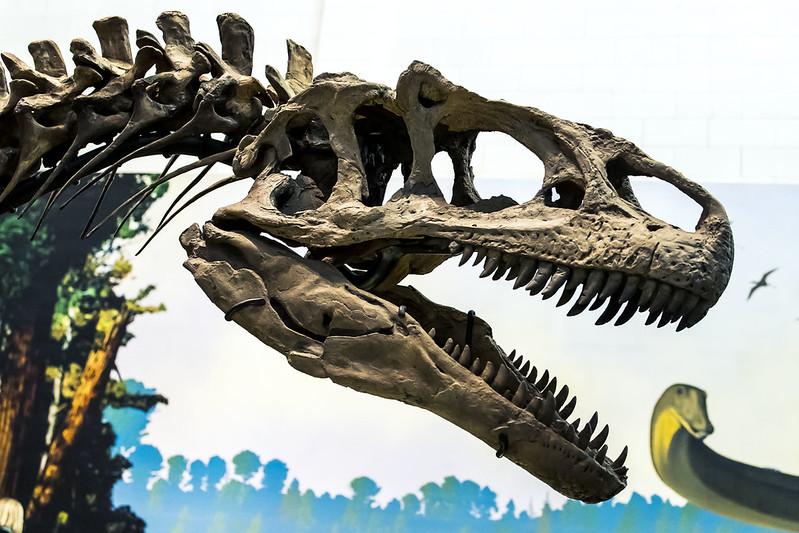
– photo by Mitch Waxman
The institution is famous for finding and identifying the Diplodocus speciation back in 1899. The skeletons above are identified as Diplodocus carnegii.
Back tomorrow with more from Pittsburgh, at this – your Newtown Pentacle.
“follow” me on Twitter- @newtownpentacle
Buy a book!
“In the Shadows at Newtown Creek,” an 88 page softcover 8.5×11 magazine format photo book by Mitch Waxman, is now on sale at blurb.com for $30.
Last steps
Friday

– photo by Mitch Waxman
That’s a Caterpillar 980c Wheel Loader, which is a piece of construction equipment that was manufactured sometime between 1987 and 1994. It weighs 66,877 pounds and is powered by a 322 horsepower engine. Behind it is the Panhandle Bridge, and there’s also a concrete company down here which has docks on the Monongahela River, here in Pittsburgh.
The Panhandle Bridge carries the T light rail service over the “Mon.”

– photo by Mitch Waxman
For the last month, whenever I’ve managed to conjure up the time to do so – and the weather has permitted it – a humble narrator has been working on developing a geospatial awareness of this place in the space twixt the ears and behind the eyes. Truth be told, I’m still working on the basics – east or west and so on. Learning the lay of the land.
That’s the T emerging from the Panhandle Bridge, on the south side of the river, heading towards a stop at Station Square.

– photo by Mitch Waxman
Since I was heading there myself, to board the T and head back to HQ, I decided to follow the elevated trackway on foot. Places like this are usually “my kind of thing.” A couple of teen aged kids were smoking the devils cabbage nearby, and they seemed to be on a date. A few people were walking dogs, and the occasional jogger or bike rider would flash by. As a rule, the bike people seem to wear “the outfit” (helmet, silky shirt, stretchy shorts, special bicycle shoes). Lots of vehicle traffic was moving around, but this was about 5 in the afternoon, so…
I began heading towards the end of my day’s movement.

– photo by Mitch Waxman
One cut through a massive for pay parking lot, found directly across the street from the light rail station, which charged $9 for all day. Given that this light rail is the start of Pittsburgh’s free zone for the T, that’s a fairly good deal. There’s parts of the area which are straight up urban, with apartment houses and all that. Saying that, Pittsburgh has a tremendous suburban and semi rural population who live in towns and boroughs which are car based. The accommodation, thereby, to get people to use mass transit rather than drive to the center, is a park and ride setup, with large relatively affordable parking facilities like this one. So far, I have not ridden the bus, but I also moved fairly close to the T’s Red Line.
The region’s bus system is fairly sprawling, and reaches far out into the surrounding counties. My understanding of that system is that you buy a parking permit for the bus operation’s park and ride lots and then head into town from whatever exurb you live in. A friend of mine suggested that the reason most of the area’s centers are spaced about 50 miles from each other is that 50 miles is about how far you could get on a horse in a single day.

– photo by Mitch Waxman
As mentioned the other day, one of my particular tasks at the moment is figuring out how to shoot Pittsburgh. Unlike NYC, with its environmental devastation and utter lack of vegetative life, there’s all sorts of forestry happening everywhere here. Getting a “clean shot” of something is fairly impossible without branches or brush intruding on the shot, so I’ve been forced into including the stuff in the composition.
Don’t get me wrong, Pittsburgh is an environmental nightmare when you get down to it – heavy industry, a permissive regulatory system, historical footprints, all that. It’s just very, very well planted with self seeding trees and shrubs.

– photo by Mitch Waxman
That’s East Carson Street pictured above, where the T comes back to ground at the Station Square stop. East of this spot is a neighborhood called the South Side Flats, which has a disturbingly heterogeneous collection of buildings and what I’m told is a thriving nightlife scene. To the West you’ll find the Station Square development area and eventually the Fort Pitt bridge, where this week’s posts began.
Next week – more, now than ever – at this, your Newtown Pentacle.
“follow” me on Twitter- @newtownpentacle
Buy a book!
“In the Shadows at Newtown Creek,” an 88 page softcover 8.5×11 magazine format photo book by Mitch Waxman, is now on sale at blurb.com for $30.


