rolled down
Down with the night, yo.

– photo by Mitch Waxman
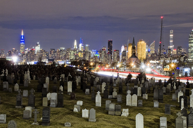
As opined yesterday, the wrought iron fence posts of First Calvary Cemetery are just the right size to stick a camera lens through. In that prior post wherein my keen observational prowess was offered, focus was given to the estimable Kosciuszcko Bridge project, while today’s set of images are a few night shots of the cemetery itself. Unless you are an absolute fanatical maniac on the subject of eating carrots or half Kryptonian, these shots are just a smidge broader than the perceptual range of human vision. The light sources are environmental, incidentally.
All I saw, with the naked eye as it were, was a silhouette of the cemetery against the skyline of the Shining City to the west.

– photo by Mitch Waxman
There were a few examples of the long exposures one returned to HQ with, wherein the camera’s sensitivity to light was enhanced in different ways, which rendered out as sort of cartoonish, and overexposed the lit up Manhattan skyline into a white blob. Saying that, I was able to reclaim an excruciating amount of detail from the shadowed areas but the images were in “the uncanny valley,” meaning that they looked utterly fake and overtly “digital.”
You can’t put a landscape picture of Calvary Cemetery up on the web without some recognizable part of the skyline in it, as a note.

– photo by Mitch Waxman
On Laurel Hill Blvd., here at the angle between Industrial Maspeth and Blissville, however – if you “go wide” the section of Manhattan between the Battery and 57th street can all be captured in one shot.
“follow” me on Twitter- @newtownpentacle
no prophet
Back in the dark, in Blissville.

– photo by Mitch Waxman
Last week, Newtown Creek Alliance organized an event in Ridgewood at a local pub which was both a “meet and greet” and an informational event. After it ended, my pal Hank the Elevator Guy offered me a ride towards Astoria in his automobile, but I asked for and instead received a quick lift over to DUKBO.
Hank the Elevator Guy was concerned for my safety, and asked if I was armed. I was, with a camera and tripod. What are you kidding, it’s Newtown Creek – that’s my house. The Kosciuszcko Bridge beckoned, so I headed over to Laurel Hill Blvd. alongside First Calvary Cemetery and got busy with the clicking and the whirring.

– photo by Mitch Waxman
The NYS DOT and their contractors are using a pretty good chunk of Laurel Hill Blvd. to store or park construction equipment, and the spot you’re looking at above used to be pretty much where the 1939 K-Bridge stood until it was demolished last year. One attended a meeting with officials from the agency not too long ago, and they indicated that the second phase of the project was on schedule and we’d be seeing both steel and concrete starting to rise out of the site this summer.
They say that everything should be wrapping up in the next 24 months or so.

– photo by Mitch Waxman
One sort of lingered about in the area, as I wasn’t being molested or eyeballed by private security. My plan, as you’ll discern from the shots in today’s post, was to accomplish the latest in a series of long exposure shots I’ve been creating all winter. Also, the climate was comfortable, atmospherically speaking.
Also, in that meeting with the NYS DOT, the head of the project indicated that the footbridge connecting 43rd street on Sunnyside’s southern extant with Blissville’s Laurel Hill Blvd. was not only completely rebuilt but was open for business. Additionally, a style of fencing inspired by the wrought iron of the cemetery fence had been installed on the structure, ideal for sticking a camera lens through, unlike the original model which was clad in chain link.

– photo by Mitch Waxman
The things I was told turned out to be true, and one enjoyed not just the opportunity to gain a bit of elevation over the deck but to also see the new bridge from a different set of angles than have been available for the last couple of years. This shot looks south over the redesigned approach ramp – connecting the Long Island Expressway off ramp to the Brooklyn Queens Expressway onramp, the latter being the road that the K-Bridge carries across Newtown Creek.
– photo by Mitch Waxman
Speaking of the LIE, that’s what it looks like from the pedestrian ramp/overpass that they’ve just built. The old structure was clad in chain link fencing, and despite there being a couple of “Bernie Holes,” here and there – POV options were always limited up here.
For those not in the know, a “Bernie Hole” is a gap in chain link fencing which was opened sometime in the 1980’s or 90’s by my departed pal Bernie Ente. There’s still a few of them around the Creek, and I’m pretty much the only one he ever entrusted the location of most of them to. “Gotta get your shot,” he would opine.

– photo by Mitch Waxman
Crossing under the LIE overpass from Blissville into Sunnyside, a humble narrator did one last setup with the tripod and associated gear. I call areas like this “The House of Moses” after Robert Moses, who slammed his roads through neighborhoods and cemeteries all over New York City and in particular Western Queens.
“follow” me on Twitter- @newtownpentacle
gleaming dome
The “A” in MTA is for “Adventure.”

– photo by Mitch Waxman
Inhuman and hideous, claustrophobic and filth ridden, the nest of Mammon and Asmodeus, home sweet hell. To say that one bears a certain disdain for Manhattan in his old age would indicate that an understatement is being offered. Manhattan? That’s not where you’ll find the solution, instead Manhattan is the problem. Vainglorious pride blinds.
These days, nobody you ask would say they “want to go” to the island of Manhattan from the other four boroughs, instead they’ll say “I HAVE TO go to Manhattan.” That’s usually when the MTA comes up.

– photo by Mitch Waxman
One such as myself gets around a lot. There isn’t a standard commute these days, rather it’s a series of odd destinations which are often set against a patchwork of neighborhoods and places unfamiliar. How do you get from Maspeth to Red Hook, or Richmond Terrace to Elmhurst? Broadway Junction connects to which trains, and are there any that near Astoria? Best transit route from Rockaway to Greenpoint, or the Bronx Zoo?
These are the sort of questions which one asks himself regularly, but last Saturday morning my problem was a simple one – get from HQ in Astoria to Lower Manhattan to do a tour on a NYC Ferry for the NY Transit Museum. As mentioned, the “A” in MTA is for “adventure,” particularly on the weekends.

– photo by Mitch Waxman
An obvious path to Pier 11 would be taking the Astoria Ferry from Hallets Cove. Unfortunately, they were operating on a winter and weekend schedule, and I would have arrived at the pier for the tour nearly an hour earlier than my customary arrival (a half hour in advance of a tour) time. I also would have to have to factor in the mile long walk to the waterfront, meaning that my journey would entail me leaving HQ something like three hours in advance of arrival if I also wanted to get breakfast, and I did want breakfast.
I decided on chancing it with the MTA, and taking the train. Realization that the Subway is now the daily gamble set in.

– photo by Mitch Waxman
I boarded an R at Steinway Street, which became an F in the tunnel. It let me off at the 63rd street station, where I had to leave the system and execute a walking transfer to get to the Lexington Avenue line’s 4/5/6 platform. There, I discovered that I had to take a 6 to 42nd street to then transfer to a 5. Luckily, the 5 got me to Fulton Street where the unpleasant miasmas of the Financial District were pulsing about in a bit of fog.
What the hell is it about Lower Manhattan with the garbage and the rats and the stink and those puddles of yellow/green bubbling water everywhere. What’s that greasy black stuff all over the sidewalks, or that liquid which just dripped on me from high above, and… blech… if you say the Newtown Creek is bad… try Fulton Street and lower Manhattan in general.

– photo by Mitch Waxman
If ever there was an area in which I’d like to set the Real Estate Industrial Complex absolutely loose, it’s a peninsular section of the Shining City just south of City Hall and north of Battery Park. Imagine it, all that filthy lucre to be made, and the developers could take turns bulldozing landmarks. The bike people could drive protected bicycling lanes right through the lobbies of buildings… What a time they’d have.
Thing is, whatever feeding frenzy might happen here will be limited evermore. Without reliable and predictable transit to carry people into Manhattan, the folks in outer boroughs might have to find other places to work that aren’t so disgusting.
“follow” me on Twitter- @newtownpentacle
ancient hill
183 square acres, and you can’t even catch a train there.

– photo by Mitch Waxman
On the way home from the Degnon Terminal and Dutch Kills, my habit is to walk up the hill on Skillman Avenue alongside the Sunnyside Yards. It’s actually set against a pretty subtle but noticeable incline, Skillman from Thomson Avenue to 39th street, and the walk is actually decent cardio (it’s no Maspeth, though). You also get to see trains along the way, which is always a plus for one such as myself. Luckily the fences are in atrocious condition and there’s all sorts of places you can stick a lens through and get some shots.
Since I had the tripod with me, I rigged it up a few times when I saw something interesting. These are long exposures, which causes passing vehicles, and trains, to blur into streaks of light. In the shot above, that’s the 7 Subway line exiting Queens Plaza above, and the Long Island Railroad transiting below.

– photo by Mitch Waxman
One of the busiest intersections I’ve ever encountered is at Skillman Avenue and Queens Boulevard. An insane amount of traffic moves through it on a twenty four hour and seven day a week schedule, heading to and from the Queensboro Bridge. There are vampires reported to be living in the steel overpasses as well, so you have to stay alert and wary around these parts because of both traffic and the undead. Queens Plaza is complicated.
That’s another 7 train at the top of the shot, if you’re the curious type.

– photo by Mitch Waxman
Crossing the yards at 39th street, which becomes Steinway Street on the other side of Northern Blvd., I did another setup at one of the many fence holes I’ve catalogued over the years. That set of green, red, and white streaks you see are a passing Long Island Railroad train at the Harold Interlocking. It’s the busiest train junction in the country, as a note, and almost 800 trains a day streak through here on their way to and from the City, last I checked.
Why is it called the “Harold Interlocking”? Ask some of the octogenarian Queensicans you meet in neighborhood bars around Sunnyside, Woodside, or Astoria and they’ll tell you that 39th street used to be called Harold Avenue back in the old days of long ago and far away. DO NOT drop John Lindsay or Bill de Blasio’s name, at your peril.
“follow” me on Twitter- @newtownpentacle
blossoming orchards
Down under the Long Island Expressway, or DULIE, in today’s post.

– photo by Mitch Waxman
So, after shlepping my tripod setup around Dutch Kills last weekend, I decided that I just wasn’t done yet. Heading east alongst the venerable avenue of Borden, a humble narrator found a few interesting spots to do a “setup” and get clicking. It was DULIE which captured my attention on this leg of the walk.
As mentioned in an earlier post, the LIE and Queens Midtown Tunnel opened for business in November of 1940. The LIE, where it crosses the sediment choked waters of Newtown Creek’s Dutch Kills tributary here in Long Island City, rises one hundred and six feet above the water. This means a lot of steel supports, and an empty corridor found beneath it.

– photo by Mitch Waxman
One is obsessed with this section of LIC, as so much has happened here. The General Electric Vehicle Company complex was just a block away, so were a couple of steel factories. A fossilized rail spur can still be found here and there, winding it way around and between the factories, but the locomotive city is long gone. It’s all about the internal combustion engine in modernity – the automobile city.
The principal proponent of the latter didn’t begin the Queens Midtown Tunnel, he just took it over towards the end of the project and made sure the LIE would be his baby. I’m speaking of Robert Moses, of course.

– photo by Mitch Waxman
The sewer grates up on the LIE connect to long vertical pipes, which just empty out onto the ground, and their flow carries all sorts of “yuck” down into LIC from the expressway high above. There’s meant to be a little concrete spillway which would carry the liquid and solute “spill” into a second grate, one which basically empties into Dutch Kills, but the build up of “crapola” around the pipe creates sickly mounds of toxic soil like the one pictured above.
Hey, I’m not judging, I love places like this.

– photo by Mitch Waxman
As a note, whenever I’m describing an encounter with the Gendarmes or some zealous security guard, I always go on about “there being no law forbidding…” and “if you can see it from the sidewalk…”.
In the case of the other night however – picture this: some weird looking bearded old man standing in pitch darkness on a Sunday night with a camera tripod under the LIE, wearing a reflective vest over a filthy black raincoat – I was ready to converse with somebody wearing a badge about what I was up to. You’d just figure that, right?
The cops though, three cruiser units worth spaced out over the evening, just drove on by me. I mean… I felt suspicious looking. The reflective vest is very good camouflage. Instead of being high visibility as promised, it’s a near invisibility prophylactic against “why are you taking pickchas of dat?”

– photo by Mitch Waxman
One was growing fatigued by this point, it was well after ten, and a humble narrator embraced an ideation about starting out for home. One last long exposure shot from DULIE was executed, and thereupon the tripod kit was folded up into its traveling configuration and a lens swap occurred.

– photo by Mitch Waxman
The lens I’ve been using for the series of night shots recently has been a Sigma 18-300 – which is by definition a “daylight lens, given that at full zoom it’s aperture is only f6.3. Tripod shots, like the ones I’ve recently been producing, make the usage of extremely narrow apertures possible – which in turn allows for a deep field of focus. Impossible for handheld usage in low light, however, this lens is. It’s singular virtue is the zoom range, ultimately. I’ve got better lenses, including a different Sigma, but this particular specimen allows me to carry just one lens.
I’ve always got a “nifty fifty” lens in my bag, however, which allows me to open up the aperture to f1.8, allowing a lot more light in. That’s the one I snapped onto the camera, which coincidentally lightened the gizmo by about a pound and a half. Lotta glass inside that Sigma, but you don’t really feel the weight of it when it’s in the bag.
“follow” me on Twitter- @newtownpentacle


