Posts Tagged ‘East River’
unknown respondent
Sludge Boats, baby, Sludge Boats.

– photo by Mitch Waxman
These shots are actually from the height of that shoulder injury period last month, and represent a desperate desire one acted upon to “shake it off” by indulging in a bit of exercise. The weather was less than cooperative from a light point of view, and the affected limb was less than pleased at the rest of my body moving around, so I decided that since I was in the “hell of pain” I’d simply head over to Hells Gate and indulge the horror.

– photo by Mitch Waxman
Luckily for my diversion starved and somewhat depressed state of mind, the MV Red Hook was observed while debarking from the Wards Island dewatering facility across the river. Wards Island is the end point for the sewage sludge process, which is operated by the NYC DEP. Centrifugal machines are fed the material, which has the consistency of syrup or warm honey at the end of the thickening process at the various neighborhood sewer plants, which is carried here by the DEP’s fleet of “Honey” or Sludge boats. The dewatered material is compressed into “cakes” and sold for use as fertilizer on non food crops such as cotton and Christmas Trees.

– photo by Mitch Waxman
MV Red Hook is one of NYC’s older generation of Sludge Boats, although it’s the newest of its type – having come online in 2012. The newer class of Sludge Boats has been discussed here at Newtown Pentacle before.
from NYC.gov
The Red Hook sludge vessel was built over a three-year period in Brownsville, Texas by Keppel AmFELS. Once completed, it took seven days to make its way to New York City, arriving on November 19, 2008. The vessel has recently completed post-delivery dry-dock inspections and adjustments at the Brooklyn Navy Yard and is ready for service. Each six-person crew consists of a captain, chief engineer, assistant engineer, mate and two mariners. Crews work a 40-hour week divided into 14, 13, and 13 hour shifts. The Red Hook is slightly over 350 feet long, about 53 feet wide, with a depth of slightly over 21 feet. It has eight storage tanks with 150,000 cubic foot capacity equivalent to 1.2 million gallons. The Red Hook weighs over 2,098 long tons and is designed to travel at 12.75 knots or approximately 15 miles per hour. On a typical week, each vessel makes 14 round trips and visits eight wastewater treatment plants.

– photo by Mitch Waxman
All of the DEP’s honey boats will find themselves heading to or from Wards Island periodically, after making their rounds at one of the City’s 14 sewer plants. Hells Gate is a great place to spot them, and Shore Road along Astoria Park is a great place to observe Hells Gate.

– photo by Mitch Waxman
There are many who would agree with me, in my assertion that the view from Shore Road rocks.
“follow” me on Twitter- @newtownpentacle
squamous litanies
It’s a real migraine out there.

– photo by Mitch Waxman
Let’s face it, what we New Yorkers actually do is raise a hell of a ruckus wherever we are, but especially so when we’re at home. Personal experience of visiting relatively rural and quiet areas, like Vermont, reveals the effect on my hearing that living in this constant din has wrought. For 24-48 hours after leaving the City, there’s a high pitched phantom tone constantly present. I’ve always thought that the “wheeeeeee” sound, in addition to having a medical definition and name, is my brains attempt to filter out the constant rumble and thunder of city life – cerebral noise cancelling if you will.
All the engines, and generators, exhaust fans, jets, car tires on asphalt, buzzing things on utility poles, everybody talking, the subways, the chattering of millions of birds – the air is polluted not just with toxic gases and sewage bacteria rising on the breeze from out of the harbor – but with noise.

– photo by Mitch Waxman
It’s only during power outages and blizzards that you get to hear the City hush up for a while. I’d settle for regular powers like being able to effectively climb a ladder or balance my check book, but a humble narrator has often fantasized about possessing some sort of super power. My first choice would be invulnerability, of course, but a lot of the really interesting choices involve sight and perception. X-Ray vision? I’d worry about giving people cancer just by looking at them. Being able to fly without the invulnerability would actually be kind of dangerous.
What if you could visualize sound?

– photo by Mitch Waxman
I know, that’s the sort of thing somebody would ask in a dorm room shortly after passing the bong, but still.
The BQE would probably look like something from Van Gogh, with crashing scalars creating fractal wavefronts which bounce and dance along the road itself and all the brick walls of the buildings which the highway weaves through. The East River would likely be a majestic sight, and would exhibit something akin to a sonic Jackson Pollack painting.
“follow” me on Twitter- @newtownpentacle
peered diligently
Visiting with an old friend, in today’s post.

– photo by Mitch Waxman
“Back in the day,” as it were, a humble narrator used to spend an awful lot of time on the Queensboro Bridge. When the 2009 Centennial Celebrations occurred, I was actually a deputy parade marshall, which the City rewarded me for with a medal. We got to close the bridge’s lower level for a few hours, and there were marching bands and a bevy of elected officials were present – including Michael Bloomberg himself. The very first posts at this – your Newtown Pentacle – discussed the event in some detail.
In recent years, as I’ve become more and more focused on Newtown Creek and its upland properties, my walks across mighty Queensboro have decreased in frequency and a recent realization that I hadn’t actually walked the span in more than a year prompted me to start kicking my feet forward and lurch roughly forward towards Manhattan. Unfortunately, this meant I was heading onto that loathsome island and leaving the intricate geometries of Queens behind for a spell.

– photo by Mitch Waxman
For those of you who haven’t taken one of NYC’s best walks, the pedestrian and bicycle lane of the Queensboro is accessed at Queens Plaza near Crescent Street. It’s not a hard walk in the least, but it does offer some fairly decent “cardio” for half of it. The long sloping ascent from Queens Plaza to the tower set into Roosevelt Island carries you hundreds of feet from the ground, and despite the gradual nature of it – you will find your heart rate increasing steadily.
Bicycles will be whizzing by at fairly high rates of speed, so be mindful of your surroundings if you decide to undertake the stroll. If you bring your camera, you will be glad you did, as the views from up on high are spectacular.

– photo by Mitch Waxman
Apparently, the incline is severely felt by bicyclists, as I’ve observed them standing on the pedals and struggling against it several times. Many will dismount and walk their bikes. The “whizzing by” mentioned above occurs once they surmount the paramount of the bridge and the descending incline allows them to gain velocity quickly.
My favorite time of day for Queensboro, visually speaking, is the middle to late afternoon. The light is spectacular during that time of day, and the intricate cantilever gears of the great bridge are evenly illuminated.

– photo by Mitch Waxman
Looking north along the East River, you’ll notice a series of steel structures which carry the Roosevelt Island Tram from Manhattan’s 2nd Avenue to the island. The tram is another one of my favorite destinations, incidentally, as it allows for a birds eye perspective on the Queensboro Bridge and the waterway it spans. One of “my walks” involves crossing the bridge, catching the tram, and then perambulating back to Astoria via the Roosevelt Island Bridge which carries pedestrian and vehicular traffic to Queens.
I’ll often stop off and hang out with my pal Judy Berdy at Roosevelt Island Historical Society when exiting the tram – which is located in a historic kiosk nearby the Tram’s landing point. You can’t miss it.

– photo by Mitch Waxman
Midpoint on the bridge, one always turns back and considers avoiding going to Manhattan altogether and returning to the poisoned loam of western Queens. In the instance of this particular journey, however, a humble narrator was set to meet up with friends in the City so I kept moving in a westerly direction.
I catch a lot of shade for the contempt with which Manhattan is discussed here. I actually used to live in the City for more than a decade, on Broadway at 100th street. Best move I’ve ever made was listening to Our Lady of the Pentacle when she announced that her desire was to move our HQ to Astoria. Back when I was a Manhattanite, my M.O. was “cocooning” – leaving the apartment only to go back and forth to work. There was no “community” to draw one out, and a vast depersonalization was experienced in the daily round. Whatever there once was that made the City an attractive place to live – night life, for instance – is long gone.
The City is a ruin, exploited and picked over and destroyed by the Real Estate Industrial Complex, and there is little fun to be had there anymore. Brooklyn and Queens are “where it’s at” these days – at least for one such as myself.
“follow” me on Twitter- @newtownpentacle
abetted by
Now there’s something you don’t see every day.
– photo by Mitch Waxman
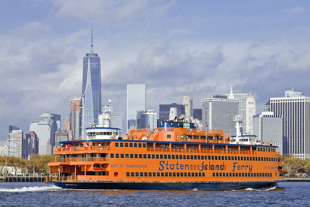
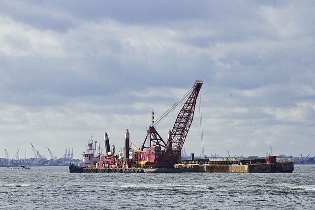
A recent Working Harbor Committee excursion to Gowanus Bay saw our vessel plying the Buttermilk Channel section of the East River, which is found between Red Hook and Governors Island. The legend about how this section of the river ended up being called Buttermilk Channel states that back in colonial times, it was so shallow at low tide that Red Hook farmers would herd cattle over to the island for safe keeping and free grazing. Dredging projects in the industrial era lowered the depth hereabouts, creating a shipping channel.
As our vessel moved along, a big orange boat called the Staten Island Ferry entered into Buttermilk, which is pretty unusual. Incidentally, despite its size, the Ferry is a boat. If it could launch a boat, it would be a ship, but since it can’t, it’s a boat. Life boats don’t count, I’m told.
– photo by Mitch Waxman
It was actually a dredging project that caused the anomaly. New York Harbor is an estuary situated between a giant conveyor belt for silt and soil called the Hudson River and the estuarial waters of Jamaica Bay and Long Island Sound. The back and forth tidal action of the East River, coupled with the titanic flow of the Hudson, causes the harbor floor to build up constantly and channel maintenance is an expensive but necessary activity ordained and financed by the ports people.
– photo by Mitch Waxman
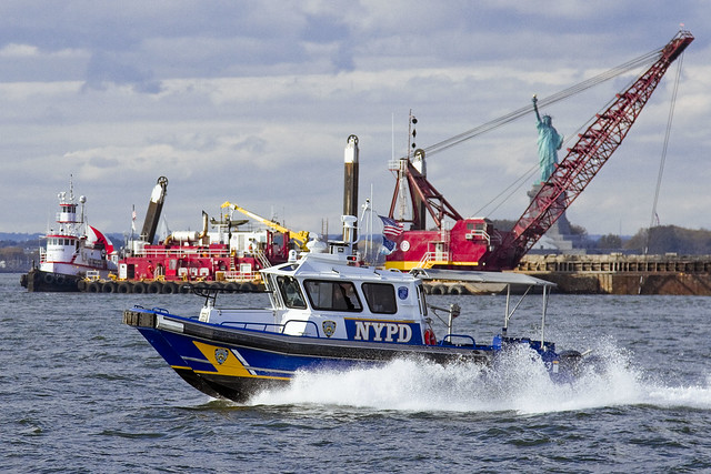
Just as we were leaving Buttermilk Channel on our way to Erie Basin and Gowanus Bay, the NYPD Harbor Patrol came splashing by, offering themselves up with an iconic backdrop.
“follow” me on Twitter- @newtownpentacle
upon all
Triborough and Hells Gate.

– photo by Mitch Waxman
As mentioned, one is taking a short break – hence the singular image which greets you above. Back soon with new stuff.
“follow” me on Twitter- @newtownpentacle
Upcoming Tours and events –
October 10th, 2015
Calvary Cemetery Walking Tour
with Atlas Obscura, click here for details and tickets


