Posts Tagged ‘Greenpoint Avenue’
bland face

– photo by Mitch Waxman
A lot of this Newtown Creek thing involves going to meetings in Greenpoint- this monitoring committee or that alliance or just some gathering at which an unelected official or designated regulator will speak at. This consumes quite a bit of time, which is amplified in my case, as I walk to the place from Astoria. Not a long walk by any stretch, roughly 3 miles, but sometimes it feels as if I spend all my time walking to and from the Greenpoint Avenue Bridge.

– photo by Mitch Waxman
Long have I been intrigued by this little fix a flat building which sits at the cross roads of Greenpoint Avenue, Van Dam St., and Review avenue on the Queens side in Blissville. Run down, it seems to be held together with tape and tacks, but there has always been something about the structure which has caught my eye. “Something” seems significant about it, given its location. Despite efforts at finding that something, it has always remained an enigma. Until now, thanks to the NYC Municipal Archives LUNA website.

– photo by Mitch Waxman
This shot, of the Sobol Brothers SOCONY station at the intersection of Greenpoint and Van Dam, is from August 20, 1930- roughly 82 years ago. SOCONY, of course, stands for Standard Oil Company of New York. Standard used to franchise out filling stations, in the same manner as its modern day incarnation ExxonMobil does. The name SOCONY indicates that the signage went up after 1911 when the Standard Trust was broken up, incidentally.
click here for the giant sharp version of the NYCMA image.
Also, at the ever reliable fultonhistory.com, I found this ad for the company, which seems to have had several locations in Queens.

slow decadence

– photo by Mitch Waxman
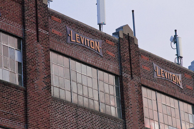
I seem to walk past this structure at least once a week, have done so for several years now, and until recently was completely ignorant about one of the largest employers of 20th century Greenpoint. The Leviton family built this commercial empire by the sweat of their brows- stories of part time employees encountering old Isidor working on the factory floor are rampant in Greenpoint, verging on Pop culture amongst garden spotters of a certain age.
from wikipedia
Leviton Manufacturing Company, Inc. is a manufacturer of electrical wiring devices, data center connectivity apparatus and lighting energy management systems. The company was founded in 1906 by Evser and his son Isidor Leviton. They began by manufacturing brass mantle tips for the natural gas lighting infrastructure in Manhattan. They sold their mantle tips on a pushcart on the Bowery on the Lower East side of Manhattan. Isidor Leviton designed a screw in lampholder for Thomas Edison’s Electric Lamp in 1910 and within ten years the lampholders were being used in every apartment in New York. In 1936 Leviton built a two square block 4 story factory and warehouse in Greenpoint, Brooklyn which still stands today. Leviton products include over 25,000 devices and systems, used in homes and businesses.

– photo by Mitch Waxman
Another bit of reputation that the family gathered unto itself was a certain liberalism regarding class, religion, and creed in their hiring practices- eschewing the segregation and selective hiring practiced by other corporations- particularly those in the electronics sector. The father of a close friend once told me that, in the years following the second world war, he was denied an opportunity to use his ivy league engineering degree because of a last name that sounded “too Italian”. Not an issue at Leviton, I am told.
from heresgreenpoint.com
By 1910 Leviton was designing and manufacturing pull-chain lamp holders for Thomas Edison’s newly developed light bulb, and in 1922 the company was moved to Greenpoint to better facilitate its rapid ascention. The massive factory took up two city blocks between Newel and Jewel Streets and produced over 600 electrical items, from fuses to socket covers to outlets and switches. Leviton would remain in Greenpoint until 1975, when the company again relocated, this time to Little Neck, NY.
– photo by Mitch Waxman
Newspaper reports describe the company as resistant to unionization, and even Eleanor Roosevelt found herself standing in solidarity with a picket line on Greenpoint Avenue in the 1940’s. In August of 1940, a large group of laborers “went out”, despite Leviton paying “benefits”- a rare and coveted perk of employment in that era. “Benefits” are what health insurance and a retirement plan were once known as, and were not an automatic or legislated requirement before the 1970’s- for those of you reading this under the age of 30, understand that these “insurance benefits” were something won by the labor movement of the early 20th century.
This was the scene of a long and contentious labor strike in 1940,
as detailed in this preview of the George Ruffini book– “Harry Van Arsdale, Jr: Labor’s Champion”, courtesy google books.

– photo by Mitch Waxman
Today, the structure is called the “Greenpoint Industrial Center” and seems to host a series of industrial, artisanal, and warehousing operations who make use of its cavernous interior spaces. The Leviton company left Greenpoint in the 1970’s, migrating to literal greener pastures in eastern Queens and ultimately Melville, Long Island.
from nationmaster.com
The Leviton Manufacturing Company was founded in New York by Isidor Leviton, at the dawn of the electrical era in 1906. Originally engaged in the fabrication of mantle tips for gas lighting, the Company soon afterwards in 1910, converted to production of a single electrical product — a pull-chain lampholder (designed for Edison’s new light bulbs).
- 1922: Leviton relocated to Greenpoint, Brooklyn after acquiring the TECCO plant, and now offered 568 products.
- 1929: Acquires Meteor Electric Company, a leading manufacturer of wiring devices.
- 1932: Leviton devices are used in the Empire State Building.
- 1937: Acquires American Insulated Wire and becomes the industry leader in wire, cable and cord products.
- 1939: Leviton devices featured at World’s Fair.
- 1950: Purchases the Deal Electric Company.
- 1953: Acquires Hale Brothers Companies, now known as Leviton Canada.
- 1960: Leviton is among the first manufactures to institute an employee pension plan.
- 1961: Leviton devices are installed in the White House.
- 1965: Harold Leviton becomes President and CEO.
- 1972: Introduces the first GFCI, the first touch dimmer, and a selection of home automation powerline carrier components.
- 1973: Introduces Decora® designer-style devices.
- 1975: Moves corporate headquarters to current location in Little Neck, NY.
_______________________________________________________________
August 5th, 2012- Newtown Creek Alliance Walking Tour- The Insalubrious Valley- This Sunday

– photo by Mitch Waxman
Newtown Creek Alliance historian Mitch Waxman will be leading a walk through the industrial heartlands of New York City, exploring the insalubrious valley of the Newtown Creek.
The currently undefended border of Brooklyn and Queens, and the place where the Industrial Revolution actually happened, provides a dramatic and picturesque setting for this exploration. We’ll be visiting two movable bridges, the still standing remains of an early 19th century highway, and a forgotten tributary of the larger waterway. As we walk along the Newtown Creek and explore the “wrong side of the tracks” – you’ll hear tales of the early chemical industry, “Dead Animal and Night Soil Wharfs”, colonial era heretics and witches and the coming of the railroad. The tour concludes at the famed Clinton Diner in Maspeth- where scenes from the Martin Scorcese movie “Goodfellas” were shot.
Lunch at Clinton Diner is included with the ticket.
Details/special instructions.
Meetup at the corner of Grand Street and Morgan Avenue in Brooklyn at 11 a.m. on August 5, 2012. The L train serves a station at Bushwick Avenue and Grand Street, and the Q54 and Q59 bus lines stop nearby as well. Check MTA.info as ongoing weekend construction often causes delays and interruptions. Drivers, it would be wise to leave your vehicle in the vicinity of the Clinton Diner in Maspeth, Queens or near the start of the walk at Grand St. and Morgan Avenue (you can pick up the bus to Brooklyn nearby the Clinton Diner).
Be prepared: We’ll be encountering broken pavement, sometimes heavy truck traffic as we move through a virtual urban desert. Dress and pack appropriately for hiking, closed-toe shoes are highly recommended.
Clinton Diner Menu:
- Cheese burger deluxe
- Grilled chicken over garden salad
- Turkey BLT triple decker sandwich with fries
- Spaghetti with tomato sauce or butter
- Greek salad medium
- Greek Salad wrap with French fries
- Can of soda or 16oz bottle of Poland Spring
for August 5th tickets, click here for the Newtown Creek Alliance ticketing page
lower edge

– photo by Mitch Waxman
While walking down Greenpoint Avenue recently, specifically that section of the ancient lane which overpasses the massive Long Island Expressway, this “Ghost Bike” caught my attention. Reckless, the political calculations which have caused the Manhattan elites to embrace and encourage cycling as an alternative form of transportation has created several spots where high speed traffic interacts directly with human powered vehicles, and tragedy has ensued. Cycling enthusiasts place these white painted bicycles at the spot where someone has died, as a memorial and a reminder to passerby.
It’s kind of a somber thing, these white bikes.
This is an “unnamed” ghost bike, according to ghostbikes.org
A livery cab driver struck and killed a cyclist in Long Island City early this morning, as first reported by DNAinfo. The motorist was not charged with any crime, said an NYPD spokesperson.
According to police, the cyclist, a man in his 30s, was riding south on Greenpoint Avenue at the time of the crash, while the livery driver, 25, was heading east on Borden Avenue, along the side of the Long Island Expressway.

– photo by Mitch Waxman
This post won’t be debating the efficacy of such alternative transportation, the wisdom of allowing vehicles to operate on the streets of New York City (motorized or human powered) without insurance or tags or operator training or licensing, or comment on the tremendous amount of traffic focused on and through Western Queens.
Instead, my attention was drawn to the slip of notepaper which was inserted into the spokes.
from wikipedia
A ghost bike or ghostcycle is a bicycle set up as a roadside memorial in a place where a cyclist has been killed or severely injured (usually by a motor vehicle) Apart from being a memorial, it is usually intended as a reminder to passing motorists to share the road. Ghost bikes are usually junk bicycles painted white, sometimes with a placard attached, and locked to a suitable object close to the scene of the accident.

– photo by Mitch Waxman
“You have a beautiful bike. Have a nice day- homeless Cassie” is what it reads. Hipster “twee” notwithstanding, this is simply in bad taste, and the writer might as well have left a note of the gates of nearby Calvary saying “nice landscaping.”
Seriously?
_______________________________________________________________
August 5th, 2012- Newtown Creek Alliance Walking Tour- The Insalubrious Valley
– photo by Mitch Waxman
Newtown Creek Alliance historian Mitch Waxman will be leading a walk through the industrial heartlands of New York City, exploring the insalubrious valley of the Newtown Creek.
The currently undefended border of Brooklyn and Queens, and the place where the Industrial Revolution actually happened, provides a dramatic and picturesque setting for this exploration. We’ll be visiting two movable bridges, the still standing remains of an early 19th century highway, and a forgotten tributary of the larger waterway. As we walk along the Newtown Creek and explore the “wrong side of the tracks” – you’ll hear tales of the early chemical industry, “Dead Animal and Night Soil Wharfs”, colonial era heretics and witches and the coming of the railroad. The tour concludes at the famed Clinton Diner in Maspeth- where scenes from the Martin Scorcese movie “Goodfellas” were shot.
Lunch at Clinton Diner is included with the ticket.
Details/special instructions.
Meetup at the corner of Grand Street and Morgan Avenue in Brooklyn at 11 a.m. on August 5, 2012. The L train serves a station at Bushwick Avenue and Grand Street, and the Q54 and Q59 bus lines stop nearby as well. Check MTA.info as ongoing weekend construction often causes delays and interruptions. Drivers, it would be wise to leave your vehicle in the vicinity of the Clinton Diner in Maspeth, Queens or near the start of the walk at Grand St. and Morgan Avenue (you can pick up the bus to Brooklyn nearby the Clinton Diner).
Be prepared: We’ll be encountering broken pavement, sometimes heavy truck traffic as we move through a virtual urban desert. Dress and pack appropriately for hiking, closed-toe shoes are highly recommended.
Clinton Diner Menu:
- Cheese burger deluxe
- Grilled chicken over garden salad
- Turkey BLT triple decker sandwich with fries
- Spaghetti with tomato sauce or butter
- Greek salad medium
- Greek Salad wrap with French fries
- Can of soda or 16oz bottle of Poland Spring
for August 5th tickets, click here for the Newtown Creek Alliance ticketing page
certain villagers

– photo by Mitch Waxman
Recent business brought me to the Greenpoint section of infinite Brooklyn, which offered your humble narrator an opportunity to get high.
Pop cultural references aside, what that meant was a trip to the roof of the so called Pencil Factory, and the chance to slide my lens around the unobstructed vista of the alluvial plane which lies between Newtown Creek, the former Bushwick Creek, and the East River.
from wikipedia
An alluvial plain is a largely flat landform created by the deposition of sediment over a long period of time by one or more rivers coming from highland regions, from which alluvial soil forms. A floodplain is part of the process, being the smaller area over which the rivers flood at a particular period of time, whereas the alluvial plain is the larger area representing the region over which the floodplains have shifted over geological time.
As the highlands erode due to weathering and water flow, the sediment from the hills is transported to the lower plain. Various creeks will carry the water further to a river, lake, bay, or ocean. As the sediments are deposited during flood conditions in the floodplain of a creek, the elevation of the floodplain will be raised. As this reduces the channel floodwater capacity, the creek will, over time, seek new, lower paths, forming a meander (a curving sinuous path). The leftover higher locations, typically natural levees at the margins of the flood channel, will themselves be eroded by lateral stream erosion and from local rainfall and possibly wind transport if the climate is arid and does not support soil-holding grasses. These processes, over geologic time, will form the plain, a region with little relief (local changes in elevation), yet with a constant but small slope.

– photo by Mitch Waxman
The pencil factory of the Eberhard Faber company, recently converted to luxury apartments, from above. Often has it occurred to me that this most be how the elites of Manhattan perceive the North Brooklyn and Western Queens communities, as if from above and with the perspective of Olympians.
from nycgovparks.org
The native Keshaechqueren originally inhabited this part of Brooklyn. Dutch mercantilists and farmers, arriving in 1638, rapidly developed it into a hub of seafaring commerce. In the 1850s, the community swelled with new residents, of primarily Irish and English descent, when two ferry lines began regularly scheduled runs from the Greenpoint coastline to Manhattan’s East Side. With the almost simultaneous addition of big businesses like the shipbuilding firm Continental Iron Works and fuel provider Astral Oil Works, Greenpoint began to compete on a national level with older naval foundries in Boston and Norfolk.
From the decades following the Civil War through the 20th century, Greenpoint’s population has steadily grown. In the early 1950s, the community began to suffer strain as several waves of immigration met with limited economic opportunities in the neighborhood.

– photo by Mitch Waxman
The red building in the right of the shot, for instance, houses one of my favorite saloons in this section- also known as the “Pencil Factory”. They serve hard cider in a pint glass with ice during the summer, and that’s what’s known as “local knowledge”. Can’t see that from up here.
Of course, this angle of view precludes one from understanding the truth of these places, the life and cultural norms of the street, and reduces the population housed therein to statistical groups with the status of mere tenants (from a macro historical and sociological point of view) in a “district”. This isn’t a district, this is a neighborhood.
Hmmm, I guess these Eberhard Faber folks must have been a big deal.
from nyc.gov
The company first opened a factory in Manhattan near 42nd Street and the East River in 1861 as the U.S. branch of Germany’s A.W. Faber Company, a pencil manufacturing company dating to the mid-18th century. In 1872, Eberhard Faber, the great grandson of the company’s founder, moved the operation to Brooklyn after the Manhattan plant – the first pencil manufacturer in the United States — was destroyed by fire.

– photo by Mitch Waxman
The shapes on the far horizon in the shot above are all in Queens, and the dark dome of vegetation are those trees fed by the morbid nutritions of Calvary Cemetery. The reason why this part of Greenpoint Avenue is so wide is that it was built to accommodate the street car lines going to and from Calvary, which met the ferry docks not too far from where the so called “transmitter park” is found today.
from “A history of the city of Brooklyn By Henry Reed Stiles” courtesy google books
The Green-point Ferries are from the foot of Green-Point Avenue, Brooklyn, E. D., to the foot of East Tenth and East Twenty-Third streets, New York. The first named route was established in 1852 (lease dated 1850), by the efforts of Mr. Neziah Bliss, of Green-Point; and was soon transferred to Mr. Shepard Knapp, being now held by G. Lee Knapp. The Twenty-Third street route was established in 1857, and held by St. Patrick’s Cathedral, per G. Lee Knapp. Rent of the Tenth street ferry, $1,300, and of the Twenty-Third street, $600 per annum, both expiring in 1874.

– photo by Mitch Waxman
Remains of the Greenpoint Terminal Market, immolated just a few years ago, persist on the riverfront. They await the application of venture capital and the blade of earth moving equipment, and will begin a conversion to towers of steel and glass.
Soon, one will not be able to see the spectacle of the Shining City of Manhattan from Greenpoint, except via regulated and officially decided “sight lines” or “visual corridors” offered by gaps between high rise apartment buildings- or if you happen to live in one of them.
Just like in Long Island City.
from the “DIGEST OF SPECIAL STATUTES By THE CITY OF NEW YORK” courtesy google books
1865: This act incorporates the Green Point and Calvary Railroad Company, and authorizes the construction of a railroad, to be operated by horse power only, from at or near the Green Point and Tenth street ferry, at the foot of Green Point avenue, in the city of Brooklyn, thence along Green Point avenue to Green Point avenue plank road, across the bridge over Newtown creek; thence easterly along said road to the easterly side of Calvary cemetery at or near the point where the, said road intersects the main road leading from Calvary cemetery to Hunter’s Point; thence to Central avenue; thence along Central avenue and Commercial street to Franklin avenue, to Freeman street, to Washington street, to the place of beginning.

– photo by Mitch Waxman
One view which will remain unoccluded for the foreseeable future, of course, is that which is enjoyed by some hideous thing which cannot possibly exist or lurk within the cupola of a Sapphire Megalith in Long Island City.
Such an entity- with its singular and unblinking eye casting about rapaciously, a global army of loyal acolytes and fanatic employees, and a desire to devour all the wealth that there is, was, or ever will be- this hungry and impossible thing which would be “too big to fail”- were it not entirely mythical- what perspectives on the transformations of North Brooklyn could it offer from atop its hildskjalf?
Of course, such paranoid wonderings often occur, when one spends his time getting high in Greenpoint.
from nyc.gov
Greenpoint is generally defined as the district bounded by North 7 Street on the south, the East River on the West, Newton Creek on the north and the Brooklyn-Queens Expressway on the east, corresponding approximately to the area of ward 17 in the 19 century. th
Once also known as Cherry Point, Greenpoint, got its name from the eponymous spit of grassy land that extended into the East River near the foot of what later became Freeman Street. The name came to designate all of the 17 ward when Greenpoint, Bushwick, and Williamsburg were joined to Brooklyn in 1854. At that time, the 17 ward was home to approximately 15,000 inhabitants. A sandy bluff, over one hundred feet high in some parts, overlooked the shoreline between Java and Milton Streets, but it was leveled before the middle of the 19 century for use as building material and landfill both in New York and locally. The original Greenpoint spit disappeared between 1855 and 1868 when the western half of the blocks along the once white sandy shoreline west of West Street were created by landfilling. During this period, the blocks west of Commerce Street between Ash and Eagle Streets were also created or in the process of being filled.
delicate individual

– photo by Mitch Waxman
Less than 2 weeks ago, I was wandering around in Greenpoint, heading for the street address of Continental Iron Works- the ship yard where the USS Monitor was laid down at West St. between Calyer and Quay near the Bushwick inlet. It was on Greenpoint Avenue when the shot above was stumbled across, close to where Newell crosses (or perhaps crossed) it. The big attractions in this neighborhood are the Newtown Creek Waste Water Treatment Plant and the Greenpoint Avenue Bridge, of course, but the acquisition of certain geographic knowledge is critical to several of my irksome studies at the moment (and even if the site has been obliterated in modernity), the efficacy of certain… theories of mine… depends on direct observation.

– photo by Mitch Waxman
While wandering about, the attention of several itinerant laborers became focused upon me, and although their jocular suggestions about destinations for my camera were titillating, my nervous nature took control over my ambitions for the afternoon and an effort was made to remove myself from their company in the fastest manner possible. The step of a coward is a quick one, but this odd truck trailer was spotted and demanded attention. I’m positive that someone else got this before me, likely Ms. Heather, but for a single moment your humble narrator stood tall to bring you its amusing visage.
…Also, I didn’t know the 7 train ran in Greenpoint…


