Posts Tagged ‘Lower East Side’
hyperbola according
Se llamo Monday.
– photo by Mitch Waxman
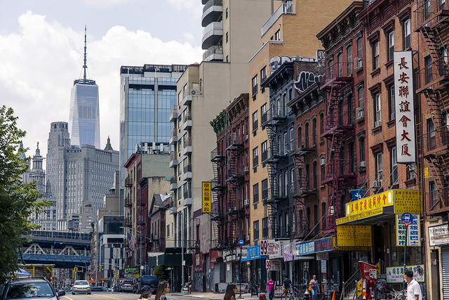
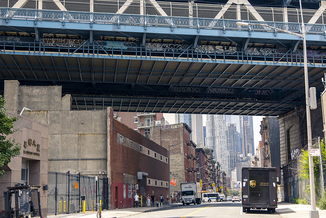
As mentioned last week, a social engagement found a humble narrator wandering the streets of lower Manhattan, specifically the “East of Bowery” section of Chinatown. My luncheon companions all decided to jump on the subway to get home, but it was a beautiful Saturday afternoon and I had nothing in particular to rush back to Astoria to do, so…
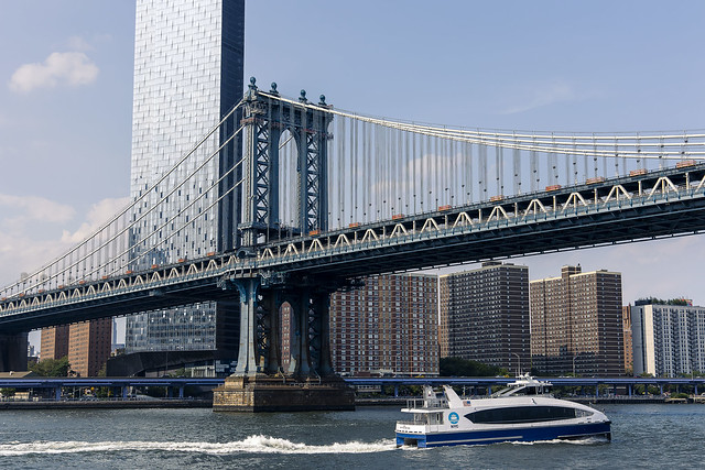
A short walk found me at Corlears Hook, which is one of the locations you can catch the NYC Ferry’s South Brooklyn service. My intention was originally formed around going one stop south to transfer onto the Astoria boat, but the ferry people were running late and I missed my connection. Given the 45 minutes I’d have to wait for the next boat, one opted to instead take a different path to Queens and I transferred onto the East River line which would deposit my stinking carcass in Long Island City’s Hunters Point section nearby my beloved Newtown Creek. Since that was going to be a while as well, I opted to stay on the South Brooklyn boat instead of waiting on the pier for the East River service, which I’d be back in time for anyway.
– photo by Mitch Waxman
What seems to have caused the Ferry schedule to unravel was the presence of a large number of recreational jet skiers on the East River. There were also abundant riders on the ferries, which caused the boats to expand their “dwell time” at the docks as the ridership loaded and unloaded. “Dwell time” is an important factor which transit planners need to incorporate into their schedules, but it’s unfortunately something that’s difficult to plan for. Somebody at MTA once told me that having somebody at a busy Manhattan hub station like Herald Square randomly hold a Subway door open for even a minute can ripple out into the entire system and cause delays for hours.
This is sort of what happened on the NYC Ferry system a couple of Saturdays ago. Missing that connection with the Astoria boat ended up costing me close to two hours and ended with having to find a way home from LIC once I hit the landward side. I’m going to suggest to the Ferry people at Hornblower (the private company which NYC uses to run the service), next time I have the chance, that they incorporate a “local” into the their lines system – one which makes all stops between Astoria and DUMBO on the Long Island coast and East 90th to Pier 11 Wall Street on the City Side. If the “local” is timed to visit these stops at the half way point between “express” service scheduling, it would ameliorate quite a few issues.
– photo by Mitch Waxman
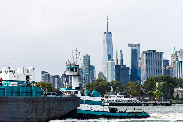
Personally speaking, I actually don’t care how long it takes to get from “a” to “b” if there’s anything interesting to point the camera at. To wit, the Crystal Cutler tugboat was steaming by Governor’s Island as the South Brooklyn Line Ferry I was on was heading northwards.
As a note, since this particular excursion played out, I’ve solved my “long lens” problem. The shot above was captured with a 24-105 lens, and regular readers of this Newtown Pentacle will tell you that I’ve been gnashing my teeth and decrying the fact that 105mm is the longest lens I own that’s native for the Canon mirrorless system which was invested in at the end of last year. Luckily, a 70-300mm lens which was purchased about 15 years ago and that I had sort of forgotten about is designed for full frame cameras and I’ve been successful at adapting it to the new system. It’s not ideal, but it’s already been paid for!
Speaking of historical lensing… what are you doing on August 7th? I’ll be conducting a WALKING TOUR OF LONG ISLAND CITY with my pal Geoff Cobb. Details and ticketing available here. Come with?
“follow” me on Twitter- @newtownpentacle
Buy a book!
“In the Shadows at Newtown Creek,” an 88 page softcover 8.5×11 magazine format photo book by Mitch Waxman, is now on sale at blurb.com for $30.
understand dimly
Shabbos… a haaa… shabbos
– photo by Mitch Waxman
Last Saturday, one had a lunch date with a few friends on Manhattan’s Lower East Side… well, actually the extremely Lower East Side. The only part of residential Manhattan that’s still remotely interesting is found between the Williamsburg and Manhattan Bridges, East of Bowery. That’s where you find architectural variation in the building stock, weird counterpoints, and an actual working class neighborhood. Don’t worry, the City and the EDC will likely declare the entire area a slum soon and knock it down in favor of glassine towers. They’re in the early stages of doing to Manhattan what they did to Brooklyn and Queens over the last few decades. Ugh.
What’s so interesting, you ask?
– photo by Mitch Waxman
Going back to the Civil War, when this section of Lower Manhattan was the center of NYC and Manhattan was still quite industrial, groups of do-gooders and reformers have shown up in every generation who had the answer to “how you help the poor.” You had Jakob Riis and his reformers – and there’s still “Old Law” and “New Law” tenement buildings extant from their solution. A generation later, the Settlement House people showed up, then came the (actual) Progressives like FDR with an enhanced education system, then Robert Moses with his urban renewal money brought highways and Section 8 housing, and then Moses and the NYCHA people built the Rutgers and Al Smith Houses and the rest. These days the do-gooder’s hustle involves “affordable housing” for the well off and screw the poor. The fossil skeletons of these behemoth movements and trends litter the streets here. A history book in brick and mortar and steel.
All of these brilliant and connected people who have tried to solve the intractable problem of urban poverty over the centuries, here in Lower Manhattan, and never did it occur any of them to just give some of the cash they were spending to the actual poor people. The core issue of poverty is that you don’t have any money, which means your babies are hungry. When you have hungry babies, you do desperate and often violent things as that makes sense in the circumstance. America’s overlords have always felt threatened by poor people, and worry that actual cash in their pockets will be drank, smoked, or gambled away. There’s a puritanical side to charitable impulses in our country. God forbid somebody on Welfare might use the money to buy their kids an ice cream cone.
– photo by Mitch Waxman
I wish that you could see through time like I can. A fire escape bolted to the front of a New Law Tenement on East Broadway? Well, that’s symptomatic of Jakob Riis and Teddy Roosevelt, as well as the formation of the FDNY after NYC consolidation in 1898 and the creation of a uniform fire code. The East Side of Manhattan’s “Chinatown” occupies a space that has long housed ethnic populations who regularly spoke languages other than English at home. German, Gaelic, Yiddish, Italian, Spanish. I wonder who made that fire escape, where was the foundry, and who got handed the license by the Tammany appointed Fire Inspectors to design and install it. Love it down here, I do, as it’s thought provoking in a way that a glass walled condo tower ain’t.
Speaking of seeing through time… what are you doing on August 7th? I’ll be conducting a WALKING TOUR OF LONG ISLAND CITY with my pal Geoff Cobb. Details and ticketing available here. Come with?
“follow” me on Twitter- @newtownpentacle
Buy a book!
“In the Shadows at Newtown Creek,” an 88 page softcover 8.5×11 magazine format photo book by Mitch Waxman, is now on sale at blurb.com for $30.
smartly curled
A visit to Manhattan, in today’s post.

– photo by Mitch Waxman
For reasons that I’d rather not go into, one had several hours to kill recently while immersed in an elevated and overtly emotional state of mind. Wandering around First Avenue and its side streets, between 14th and 23rd street, happenstance carried me to 415 14th street where one may notice that the Church of the Immaculate Conception stands. The address once belonged to a Presbyrterian outfit that called itself “Grace Chapel” but after the construction of Stuyvesant Town and Peter Cooper Village annihilated the Roman Catholic original “Immaculate Conception” across the street, the Catholics purchased the building and moved in. They’ve been here since 1946, I’m told.
from immaculateconception-nyc.org
In 1914, the Metropolitan Life Insurance Company embarked on one of the most successful urban renewal projects in the history of New York City. It created Peter Cooper Village and Stuyvesant Town to address a projected housing shortage among returning World War II veterans. The Met, as it was known in those days, bought up block after block of the area between 14th and 23rd Streets, from First Avenue to Avenue C. Included in the purchases were Immaculate Conception Church, its rectory, convent and school buildings.
The Archdiocese of New York then purchased an Episcopal mission settlement, Grace Chapel, on the south side of 14th Street, East of First Avenue. It was renamed “Immaculate Conception.”

– photo by Mitch Waxman
The Lower East Side, along with Harlem, barely resembles the neighborhood I remember from the 1980’s. This particular corner used to be a good place to die, or at least catch a scorching case of death, and there was a bit of a fortress mentality to the area back “in the day.” Junkies, addicts, and the whole crew of loathsome indigents who called the L line Subway station on 14th “HQ” used to pollute the sidewalks hereabouts. It was odd to see the gates to the church open, and a sign promised that there was a cloister back here, so I scuttled onto the property to take a look.
from wikipedia
A cloister (from Latin claustrum, “enclosure”) is an open space surrounded by covered walks or open galleries, with open arcades on the inner side, running along the walls of buildings and forming a quadrangle or garth. The attachment of a cloister to a cathedral or church, commonly against a warm southern flank, usually indicates that it is (or once was) part of a monastic foundation, “forming a continuous and solid architectural barrier… that effectively separates the world of the monks from that of the serfs and workmen, whose lives and works went on outside and around the cloister.”

– photo by Mitch Waxman
Unfortunately, the so called cloister seems to have converted over to a parking lot, so there wasn’t too much to see. There’s also a parochial school back here, and for some reason – unaccompanied middle aged men with cameras seem to set off alarm bells when the subject of school children comes up so I headed back out to 14th street. I did stop into the chapel, but there were bunches of adherents praying in there and I didn’t want to disturb their reverie or violate their privacy by taking photos.
It’s quite lovely in there, however.
from wikipedia
Stranger danger is the danger to children presented by strangers. The phrase stranger danger is intended to sum up the danger associated with adults whom children do not know. The phrase has found widespread usage and many children will hear it (or similar advice) during their childhood lives. Many books, films and public service announcements have been devoted to helping children remember this advice. The concept has been criticized for ignoring the fact that most child abductions and harm result not from strangers, but rather from someone the child knows.

– photo by Mitch Waxman
On the front of the church, there’s a public fountain. There aren’t many of these 19th century artifacts left in Manhattan – I can think of one in the west village and a couple down near the City Hall/Canal Street area that was once known as the Five Points, but it’s a rare thing to spot them anymore. I’m far more surprised that it survived the urban renewal period of the 40’s and 50’s than our current era of gentrification, actually. It’s more than likely that there used to be a common cup chained to the fountain, not unlike the one displayed in a period photo at ephemeralnewyork in the link below.
from ephemeralnewyork
This 1913 photo shows a boy at a public water fountain in Madison Square Park; he’s drinking from a common cup attached to a chain. Of course, no one today would ever drink from the same cup thousands of strangers also put their lips on. But back then, in pre-germ-awareness times, not everyone realized how unsanitary it was.

– photo by Mitch Waxman
I’m no metallurgist, but to me the fountain seems to be bronze. There’s a basin and two ornamental fishes, the latter were where the water was dispensed into the former. If you think its difficult finding a place to sit down or use a toilet in 21st century Manhattan, you couldn’t imagine how rough it would have been back in the late 19th century.
Back then, this part of the Shining City was a thriving immigrant neighborhood of tenements and small factories that extended to the East River. The other side of the street, where Stuyvesant Town currently squats, was once a slum called “The Gaslight district.” Amenities like this drinking fountain were acts of charity offered to the affected masses by the well off. On the masonry above it is the legend “Ho, everyone that thirsteth.”
from wikipedia
In 1842, one gas storage tank at East 23rd Street and the river was erected, quickly followed by the construction of other gas tanks, and by the late 19th century, the site of the complex had become known as the Gashouse District because of the many tanks that dominated the streetscapes. The tanks, which sometimes leaked, made the area undesirable, as did the Gas House Gang and other predators who operated in the area. With the construction of the FDR Drive, the area began to improve. By the 1930s, all but four tanks were gone and, while shabby, the area was no more blighted than many parts of the city after the years of the Great Depression; crime in the district had been endemic, however. When Alexander S. Williams was promoted to police captain and assigned to the area, he met the gangs’ violence with equal force of his own, putting together a brute squad that beat up gangsters with clubs. He commented: “There is more law at the end of a policeman’s nightstick than in a decision of the Supreme Court.

– photo by Mitch Waxman
At the base of the bronze fountain is a legend offering the birth and death dates for a person named “Fanny Garretson Russell.” I looked around the web for information on this inscription, which you’d think would be well documented due to its presence in Manhattan, but found nothing.
“OK” thought I, and utilizing some of my “find the hidden history of Queens” skills, I got to work-
Fanny was the grand daughter of Charles Handy Russell, of Providence Rhode Island. Russell’s father was a Major in the continental army during the American Revolution, and the family history goes all the way back to the Mayflower on one side and the founding of Woburn, Massachusetts in 1640 on the other.
Charles Handy Russell came to New York in the 1820’s, rising to a position of financial and political prominence. Russell was a railroad man, the President of the Bank of Commerce, dabbled in maritime insurance, was part of the original board of directors in charge of Central Park, and a husband to Caroline Howland. The couple had children: Charles Howland Russell – who was the Private Secretary of the United States Secretary of State during the administration of President Hayes, and Samuel Howland Russell were amongst them.
Samuel, a mining engineer who graduated from Columbia University, married Elizabeth Watts Garretson in June of 1884. Their first daughter was named Fanny, who died on the 23rd of August in 1894. This fountain’s dedication is to her.
“follow” me on Twitter- @newtownpentacle
idle curiosity
In today’s post- The New York Marble Cemetery on Manhattan’s Lower East Side.

– photo by Mitch Waxman
If your view of second avenue in Manhattan’s East Village looks like what you see in the shot above, there’s only one place you can possibly be.

– photo by Mitch Waxman
You would be standing on the other side of these gates, found at the end of an alley, and within a walled off corridor which was established in 1831- the same year that the French Foreign Legion first deployed and Charles Darwin left England for the Galapagos onboard the Beagle.

– photo by Mitch Waxman
One of the perks of working with Atlas Obscura is that I can sometimes insert myself into somebody else’s adventure, and in this case, it was Allison Meier’s walking tour excursion to the New York Marble Cemetery at 41 1/2 Second Avenue. She graciously allowed me to attend her sold out tour.

– photo by Mitch Waxman
Check out this page, which I think Allison wrote- at the Atlas Obscura– for the full history of the place (there’s no point in me paraphrasing it). The tombs are all underground, with the grave markers arranged on the walls in the form of stone plaques. The surrounding neighborhood has literally risen around the place, with every building style from 19th century tenement to ultra modern luxury hotel represented around it.

– photo by Mitch Waxman
The president of the cemetery association was there to talk to the attendees, and she described the walls as being quite fragile and in bad condition. Nearly two hundred years of New York air, and vibration, have taken their toll on mortar laid down just ten years before Mary Rogers “the beautiful cigar girl” was found in a trunk floating along on the Hudson- sparking the interest of none other than Edgar Allen Poe.

– photo by Mitch Waxman
Pictured above is the plaque denoting the tomb of Uriah Scribner, father of the eponymous founder of the publishing house “Charles Scribner’s Sons.” Uriah died in 1853.

– photo by Mitch Waxman
1830’s New York City is literally the stuff of legend.
It’s Poe’s town, as well as the NYC that Herman Melville and Washington Irving and William Cullen Bryant knew, a city which had less than a quarter million inhabitants. What we call the lower east side was farmland back then, and the center of town was down near the Battery.
The river fronts were described as a “forest of masts” for all the merchant trading vessels found docked there.
Check out the New York Marble Cemetery here.
“follow” me on Twitter- @newtownpentacle
Want to see something cool? June 2013 Walking Tours-
The Poison Cauldron– Saturday, June 15, 2013
Newtown Creek walking tour with Mitch Waxman and Atlas Obscura, tickets now on sale.
Kill Van Kull– Saturday, June 22, 2013
Staten Island walking tour with Mitch Waxman and Working Harbor Committee, tickets now on sale.
The Insalubrious Valley– Saturday, June 29, 2013
Newtown Creek walking tour with Mitch Waxman and Newtown Creek Alliance, tickets now on sale.
supposedly solid

– photo by Mitch Waxman
The DEP Pump House described in yesterday’s posting, which is located in Manhattan’s “Alphabet City” neighborhood, is found across the street from Con Ed’s East River Generating Station. Both facilities are, in turn, surrounded by vast residential complexes which long time New Yorkers might refer to as “The Projects“.
Governmental officials would prefer the term “affordable housing“, of course, or at the very least- “The Jacob Riis Houses”.
from wikipedia
The New York City steam system is a district heating system which takes steam produced by steam generating stations and carries it under the streets of Manhattan to heat, cool, or supply power to high rise buildings and businesses. Some New York businesses and facilities also use the steam for cleaning, climate control and disinfection.
The New York Steam Company began providing service in lower Manhattan in 1882. Today, Consolidated Edison operates the largest commercial steam system in the United States. The organization within Con Edison that is responsible for the system’s operation is known as Steam Operations, providing steam service to nearly 1,800 customers and serving more than 100,000 commercial and residential establishments in Manhattan from Battery Park to 96th Street uptown on the West side and 89th Street on the East side of Manhattan. Roughly 30 billion lbs (just under 13.64 megatons) of steam flow through the system every year.

– photo by Mitch Waxman
The subject of the post today has little to do with the aforementioned complex of buildings, they are mentioned strictly for contextual and geographic orientation of the Con Ed facility. My understanding is that this “cogeneration” facility is considered to be a desirable target to those ragged armies of third world sappers commonly referred to as “terrorists“, and several acquaintances and or friends have found themselves being interviewed by Police and Security personnel merely for having photographed the place.
from coned.com
In the grand tradition of the Jumbo dynamos, the six-story boilers installed at Fourteenth Street and East River were so large that a luncheon for nearly 100 people was served inside one of them before the renovated station went into operation in the late 1920s. During the opening day ceremony in 1926, Queen Marie of Rumania flipped the switch to start the 100,000 horsepower turbine generator.

– photo by Mitch Waxman
The view in the first two shots are from the East River, captured while onboard aquatic vessels, and the shot above is actually from the roof of the DEP Pump house.
The housing complex in the shot above is not true “public housing”, rather it is the Stuyvesant Town property. After the second World War, “urban renewal” projects such as the Riis Houses and Stuyvesant Town were seen as the answer to the endemic poverty found around and propagated by tenement slums. Funding and political impetus for large scale developments such as these- inspired by the ideations of a cryptofascist architect, LeCorbusier, and his disastrous “Tower in a park” conception- were made possible by both Federal and entrepreneurial sources.
Located on the east side of Lower Manhattan, the 43,000-sq.-ft. facility produces electricity and steam for homes and businesses throughout New York City. The project was completed May.
To repower the 360-MW power plant, the project team is performing all civil, structural, electrical and mechanical work, including the installation of major equipment, such as two GE Frame 7FA gas turbines, two Vogt-NEM, Inc. heat recovery steam generators and three Atlas Copco gas compressors. More than 100,000 lin. ft. of process pipe will be installed.
Construction of a new, onsite water treatment plant is also a part of the contract. The new treatment plant will consist of a 9,000 GMP reverse osmosis system that will produce pure water for steam generation. Electrical work includes the installation of 77,000 lin. ft. of conduit, 15,000 lin. ft. of cable tray, 665,000 lin. ft. of power and control cable and 30,000 electrical terminations.

– photo by Mitch Waxman
Historically, this area was known as the Gas House District, so named for an enormous number of multi story “high pressure” tanks and the hundreds of associated industrial buildings which serviced and supplied them. A network of pipes snaked out into Manhattan from the East River, supplying fuel to street lights, commercial customers, and even residences.
The adage “Don’t blow out the light” was displayed prominently in hotels and flop houses all over town during the 19th century, as newcomers to the City would often treat a gas light in the manner they would a candle- which would have disastrous, fatal, and often explosive results. The District followed the East River and extended from 14th to 27th streets.
The neighborhoods surrounding the Gas Light District was notorious for its violent crime.
from gsapp.org
Address: East 14th Street
Architect: Thomas E. Murray/Unknown
Date: 1926/1950s
The Consolidated Edison Company’s East River Generating Station dominates the eastern section of 14th Street, stretching from 13th and 17th Streets and between Avenue C and the East River. It was erected primarily in two phases, the first campaign completed in 1926 and the second in the 1950s. Because of its size and prominence, the East River Generating Station plays an important role in the history of the East River waterfront, as well as in the general evolution of power plant architecture in New York City. The widespread low-scale fabric of the Lower East Side, consisting mostly of tenement buildings, went generally unchanged for most of the nineteenth century and the early part of the twentieth century, while the rest of Manhattan was seeing the erection of skyscrapers and other tall buildings.
Driven by the increasing cost of power plant construction and the need to design “with an eye to the future,” the East River Generating Station of 1926 was designed to be less ostentatious than earlier stations that were typically of the Beaux-Arts Style, yet it was also less monolithic than contemporaries such as Hell Gate or Hudson Avenue Stations. The waterfront façade of this building was divided into three distinct bays in rectilinear form, a design scheme that allowed for easy expansion as need be. The building uses vertical fenestration and horizontal bands of limestone set within a field of dark red brick to give the façade a sense of visual excitement


