Posts Tagged ‘Maspeth Creek’
ominous things
Tuesday’s are the most malign days of the week.

– photo by Mitch Waxman
That puddle there is permanent. I’ve walked through this section of Maspeth during summertime drought conditions when it was hot enough to bake bread on the sidewalk and that puddle permanently persists. I’m told this is one of the lowest spots in NYC, as far as it’s relationship to sea level, which I’ve been known to describe this spot as being “the bottom of a soup bowl” that’s formed by the high grounds surrounding the alluvial flood plane of the legendary Newtown Creek.
There’s a sewer grate under the puddle somewhere, one which is choked by concrete and street garbage, which is meant to drain directly into the Maspeth Creek tributary of the larger Newtown Creek waterway without ever visiting a sewer plant. This is puddle is more or less on the spot where the town docks of Maspeth would have once been found, where DeWitt Clinton dreamt up the Erie Canal. I can see through time, but time is only a construct, as everything is actually happening all at once. We live in an explosion, and there are puddles.

– photo by Mitch Waxman
Puzzling statement, no? Well – ponder it, bro. I don’t want to get into chemical decay and quantum states in today’s post. Puddles, that’s my bag, bro.
The big plumbing warehouse whose property sits behind both the eternal puddle, and a fence, used to be the United Enameling and Stamping Company. They made bathtubs and sinks and toilets and the sort of stuff that connected such items to water supply systems as well as enameled cooking equipment. Their huge parking lot used to be filled with dipping tanks, which were filled with esoteric compounds and cancer juices used in their manufacturing processes.

– photo by Mitch Waxman
Next door to the plumbing warehouse is a concrete company – Ferrara Bros. You see their characteristic orange trucks making deliveries all over the City. This isn’t Ferrara’s only corporate footprint, here in industrial Maspeth. I think they’ve got a couple more giant factories in other boroughs, possibly another one in eastern Queens but I’m guessing there and can’t be bothered to find out more.
By my count, there are three big concrete processors around Newtown Creek. Ferrara Bros. here in Maspeth, NYCON at Dutch Kills in LIC, and Tec-Crete Transit mix over in Ridgewood. There’s others, of course, but that’s the three who more or less touch the shoreline of the lugubrious Newtown Creek.
Note: I’m writing this and several of the posts you’re going to see for the next week at the beginning of the week of Monday, January 18th. My plan is to continue doing my solo photo walks around LIC and the Newtown Creek in the dead of night as long as that’s feasible. If you continue to see regular updates here, that means everything is kosher as far as health and well being. If the blog stops updating, it means that things have gone badly for a humble narrator.
“follow” me on Twitter- @newtownpentacle
Buy a book!
“In the Shadows at Newtown Creek,” an 88 page softcover 8.5×11 magazine format photo book by Mitch Waxman, is now on sale at blurb.com for $30.
suggesting question
Canada Goslings in industrial Maspeth.

– photo by Mitch Waxman
Marching about recently, my path carried the camera past Maspeth Creek, which – as the name would imply – is in industrial Maspeth and is in fact a tributary of that lugubrious cataract of cautionary tales known to all simply as the “Newtown Creek.” Whilst scuttling past the Maspeth Creek waterway’s head waters, which flow out a sewer, these Canadian invaders were shifting from foot to foot in a manner which I did not like.
Geese, in general, are dicks. Canada Geese, in particular, are jerks as well as dicks.

– photo by Mitch Waxman
The good news, for this dick specie, is that there’s now more of them. “Goslings” are what you call baby geese. While I was shooting this, one of the adults – I’m presuming it was the papa – was ambling towards me while sticking his tongue out. I once had to punch a goose in the face at one of the area cemeteries to ward off an attack. This particular paragon of poultry was intent on killing me for wandering too close to a nest, I guess. For you PETA types out there, one tried every other recourse first including “flight” before “fight” became my only option. That “sumbitch” chased me half way across Calvary Cemetery before I had to vigorously assert my right to be unmolested with a closed fist.
Seriously, Geese are mean dicks, but they’re real cute when they’re babies.

– photo by Mitch Waxman
The one who was messing with me the other day is the big one, at the back of the group in the shot above. I’m not sure if Maspeth Creek is in the 108th or the 104th precinct, but if anyone recognizes that goose I’d appreciate it if you called the NYPD tips line and let them know. I bet that its name is Claude or Jean or something… pfft… Canada.
Back in conventional reality, rather than within my inner dialogue about rude avian biota, the Canada Goose is one of the many, many birds that arrive at Newtown Creek each and year.

– photo by Mitch Waxman
Newtown Creek, and all of NY Harbor, sits in the migratory Atlantic Flyover zone. Every year you get to see nestlings putting on weight and size all summer long around the creek. Towards mid August and late September, they’ll begin vacating the area for parts unknown, returning in late March and April.
There’s a bunch of them wallowing around in the toxic sediments of Maspeth Creek, in the shot above.

– photo by Mitch Waxman
Most of what I look out for as a hazard around the Newtown Creek are trucks rather than birds, and while making my way home, one marveled at all the different kinds. Semis, packers, roll on and roll offs, panel, box, wreckers, concrete… I even saw a couple of crane trucks. Industrial Maspeth is lousy with that sort of thing. There’s trains, too.

– photo by Mitch Waxman
Leaving the Maspeth area via 48th street, you cross under and over the Long Island Expressway while heading north into Sunnyside. I like to use this steel and concrete landmark, a corridor of the House of Moses, to mentally signal that I’ve left the Creeklands and reentered the world as it’s meant to be.
As in, if an aggressive goose showed his face around south Sunnyside, he’d soon find himself cooked.
Upcoming Tours and Events
June 22nd – The Birthplace of Mobil Oil: A Walking Tour
– with Newtown Creek Alliance.
Join NCA historian Mitch Waxman and NCA’s project manager Willis Elkins for walk through the birthplace of Mobil Oil, past the DEP’s largest Wastewater Treatment Plant and to the Kingsland Wildflowers green roof. The tour will also visit NCA’s Living Dock on the way; showcasing restoration efforts adjacent to major industrial operations and in the wake of legacies of pollution and neglect.
The tour will end at the 22,000 square foot Kingsland Wildflowers project, with panoramic views of the Newtown Creek and Manhattan skyline at sunset.
Tickets and more details here.
June 30th – The Skillman Avenue Corridor
– with Access Queens.
Starting at the 7 train on Roosevelt Avenue, we will explore this thriving residential and busy commercial thoroughfare, discussing the issues affecting its present and future. Access Queens, 7 Train Blues, Sunnyside Chamber of Commerce, and Newtown Creek Alliance members will be your guides for this roughly two mile walk.
Skillman Avenue begins at the border of residential Sunnyside and Woodside, and ends in Long Island City at 49th avenue, following the southern border of the Sunnyside Yards for much of its path. Once known as Meadow Street, this colonial era thoroughfare transitions from the community of Sunnyside to the post industrial devastations of LIC and the Dutch Kills tributary of Newtown Creek.
Tickets and more details here.
“follow” me on Twitter- @newtownpentacle
betraying myself
Like the ghouls and ghasts, loosed upon the night wind.

– photo by Mitch Waxman
As described in yesterday’s post, one decided to take advantage of the atmospherics offered by temperature inversion last week and proceed to hike over to Newtown Creek from Astoria at four in the morning. As also mentioned in the prior posting – the manifestations of high humidity like fog and mist, coupled with spring like temperatures, created a physically arduous environment. Perspiration offered an abundance of skin secretions for my clothing to absorb, which, combined with worries about condensation on camera and lens – caused a rather uncomfortable series of existential challenges to endure. No one ever promised me a rose garden, however, so your humble narrator soldiered on into the night.
The apex of this part of Laurel Hill, sitting alongside a shallow valley through which a lost tributary of the lugubrious Newtown Creek which was known as “Wolf Creek” once flowed, is always that moment when a humble narrator comments to himself that the creeklands have been reached.

– photo by Mitch Waxman
Calvary Cemetery’s newer sections are on the left side of the shot above, and the “House of Moses” occupies the center. That’s the Long Island Expressway at center and above, with industrial Maspeth to the right.
This is where 48th street, whose gradual climb in altitude I had been ascending since Northern Blvd., begins to slope roughly towards the elluvial flood plains of the Newtown Creek. Once, this ancient road was paved with crushed Oyster Shells. That colonial era surface would have been replaced with horse and carriage friendly Belgian Blocks (colloquially known as cobble stones) shortly before the Civil War, and later in the 19th century by tar and Macadam. The modern road is formed out of a concrete bed underpinned by steel rebar and is paved in a petroleum industry waste product called “Asphalt.”

– photo by Mitch Waxman
Industrial Maspeth never knows sleep.
There are vast fleets of trucks, locomotives, and shifts of laborers converging at all hours of the day and night on this area, and on every day of the year (except Christmas and Thanksgiving, mostly). Sodium street lamps lend the place a sickly yellow glow, and the harsh illumination of passing heavy trucks provides for occasional blinding white blasts of light.
One has received “safety training” from Union laborers and corporate entities over the years, so a certain amount of confidence in how to handle oneself in locales such as this informed my actions. Donning an orange safety vest with reflective strips was one of the preparations made before leaving Astoria, incidentally. Night time in an M1 zone is one of the few times when the wandering photographer definitely WANTS to be noticed.

– photo by Mitch Waxman
There are lots of giant machines moving around in industrial Maspeth, and 21st century industrial America operates within and promulgates a certain cultural imperative. That culture is called “workplace safety” and it’s important to understand the “lingua Franca,” customs, and mores which these laborers operate within – and their expected cultural normatives – as one moves about.
As a rule, never walk in front of a truck or any sort of machine without its operator acknowledging your presence, and if possible indicate to them which way you will be going and wait for them to further acknowledge that before proceeding – that’s one of them. Another is to not just wander across a driveway without looking. These hard working people aren’t expecting some idiot with a camera to be wandering around at 4:30 in the morning, after all, and the cops don’t exactly enforce the 25 mph speed limit around these parts.

– photo by Mitch Waxman
At the bottom of the hill into which 48th street was carven, the grid of the streets is broken, and you can either head west towards Blissville in Long Island City or deeper into industrial Maspeth to the east or south. The Long Island Railroad tracks are found just beyond the fence line pictured above. That’s Review Avenue/56th Road/Rust Street you’re looking at. This is the very definition of a “not pedestrian friendly” intersection and is a dangerous crossing when on foot or a bike.
How dangerous is it, you ask?

– photo by Mitch Waxman
Another one of the thousands of ghost bikes is found here, a roadside memorial to someone who got squished. Every time you find a ghost bike, you find a human life cut short.

– photo by Mitch Waxman
Crossing the LIRR tracks. It should be mentioned that the “Haberman” section of these tracks are quite active these days, and that the signals are in terrible condition. Over the summer, just east of here, a truck crossing the tracks was swept away by a freight train. The exact spot which this shot was captured saw a similar incident occur a couple of years ago. In both cases the barriers never came down, the bells and flashing lights never sounded, and unlike the summer 2015 event to the east – this is where a fatality occurred.
In the distance, the Kosciusko Bridge project lights the horizon.

– photo by Mitch Waxman
There’s a bit of lens flare present in the shot of the Ferrarra Brothers Concrete trucks above, but there’s little one can do about that in context. The shots in today’s, and yesterday’s, post are almost entirely handheld. High ISO settings, coupled with a “wide open” aperture, and compensating for the counterpoints of bright artificial light and enveloping darkness make for quite the technical challenge. It’s all about technique, shooting postures, and being able to force the camera into “seeing the light.”
Sometimes that means light is bouncing around inside the lens, producing flares. “Work with it” as my pal Bernie Ente used to say.

– photo by Mitch Waxman
Heading towards Maspeth Creek along 49th street. I’ve been told that this, the section of 49th pictured above, is actually one of the lowest places in NYC – in terms of altitude relative to sea level and the sewer shed that feeds into the Newtown Creek. It’s a guarantee that you’ll alway see some flooding here every time it rains, which is something I can say with authority, and based on observation.
An apocryphal story offered by one of my many neighborhood informants stated that during a Hurricane Sandy, geysers of water were erupting from the sewer grates and manhole covers in this spot.
– photo by Mitch Waxman
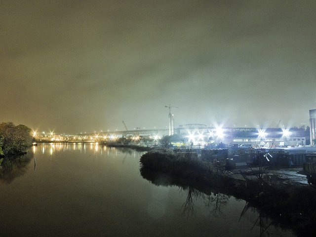
The shot above, depicting Newtown Creek’s tributary “Maspeth Creek” on a foggy night in November of 2015, was actually the first tripod shot which I popped off last Thursday.
I bagged the dslr momentarily, and employed my trusty old Canon G10 with its magnetic tripod and a remote shutter release. The magnet allows me to “clang” the camera onto fences, fire hydrants, anything ferrous. The shot is a 15 second long exposure, which characteristically causes water to assume a mirrored glass like appearance. In the distance – the Kosciusko Bridge, with Manhattan’s skyline lost in the mist rising from that malign example of municipal and corporate excess known only as the lugubrious Newtown Creek.
Tomorrow – more.
“follow” me on Twitter- @newtownpentacle
sacred grove
“follow” me on Twitter at @newtownpentacle

– photo by Mitch Waxman
Maspeth Creek, at low tide, does not smell like lilacs. A lot of that is due to the natural actions and out gassing of exposed mud flats, but the miasma which plagues the area around it is due to the combined sewer outfall (CSO NC-077, which discharges better than 288 million gallons a year of untreated sewerage into the water). The waterway, severely truncated and canalized, was locked into its current shape and size back in 1914 by the Army Corps of Engineers at the behest of the United States War Department. Nearby was the LIRR Haberman siding, and this was a strategic locale during the early 20th century full of chemical plants and manufacturing companies.
Once, Maspeth Creek ran nearly all the way to Elmhurst, rather than ending in an open sewer.

– photo by Mitch Waxman
Descriptions of this area, in particular, tickle the fancy of those who come to Newtown Creek with preconceived notions about the place. Here they find stink and sediment mounds, and witness abandoned cars dissolving slowly into its waters. As early as 1908, reports of the area describe it as a “dismal swamp, distributing evil smells and ugly to the last degree.” Witnesses in the early 20th century detailed the presence of railroad yards, factories, acid running from open pipes into the water, fat boiling in open vessels, oil works and chemical yards.
Nearby were the bone blackers, fat renderers, and every sort of malodorous occupation imaginable.

– photo by Mitch Waxman
It is mysterious, to me, that I have been unable to find mention of the place in literature from the so called “muck raker” era whose setting involves this area- the closest you get is in “A Tree Grows in Brooklyn.” Accounts of Packing Town in Chicago abound, notably in Upton Sinclair’s “The Jungle.” Nellie Bly drew a cogent picture of being institutionalized on Blackwells Island in “10 days in a madhouse” and everyone from Walt Whitman to Horace Greely have left behind accounts of the miseries of Manhattan’s working class communities and the horrible conditions encountered around the factories which lined its riverfront shorelines.
How odd it is that this spot, so close to the geographic center of New York City and with a rich colonial era history, has escaped comment by any other than just a few long dead journalists and a half dead yet humble narrator.
Upcoming tours:
Parks and Petroleum- Sunday, May 12, 2013
Newtown Creek walking tour with Mitch Waxman and Newtown Creek Alliance, tickets now on sale.
The Insalubrious Valley– Saturday, May 25, 2013
Newtown Creek walking tour with Mitch Waxman and Atlas Obscura, tickets now on sale.
unknown magic
“follow” me on Twitter at @newtownpentacle

– photo by Mitch Waxman
After the event at the Newtown Creek Wastewater Treatment Plant on Friday the 26th, Newtown Creek Alliance Executive Director Kate Zidar and I had to hurry over to another location on the troubled waterway for a second event.
This one was taking place at the Maspeth Creek tributary in Queens.
The New York State Department of Environmental Conservation and the Newtown Creek Alliance invite you to a special event to celebrate New York’s wildlife and Earth Week!

– photo by Mitch Waxman
The NYS DEC have released a new book as part of the “watchable wildlife” initiative, which seems to be a state wide effort to promote eco tourism. The administrative head of the NYC region 2 is Venetia Lannon, who is actually a very cool person in real life, and she was there to speak to the gathered bird enthusiasts, Newtown Creek Alliance members and Creek devotees, as well as members of the local press.
from dec.ny.gov
Whether it’s the spectacle of a soaring eagle or a glimpse of a river otter, here you’ll find what you need to plan a great wildlife viewing experience in New York State. DEC’s wildlife experts help you learn where to find wildlife, what sounds to listen for, or when to look for your favorite animal. Find a full list of wildlife viewing sites in New York State with many new locations just released and see our full list of wildlife species.
Have you checked out the new New York Wildlife Viewing Guide? In it you’ll find more than 100 of New York’s best sites to see wildlife near home or while on a trip. New York State has millions of acres of state parks and forests, preserves, and wildlife management areas (WMAs) each offering tremendous opportunities for wildlife and nature viewing. Take along the New York Wildlife Viewing Guide on your next outdoor adventure! Available soon for your E-reader and electronic devices; purchase a copy on the web, in bookstores, or at watchablewildlife.org.

– photo by Mitch Waxman
In addition to the DEC’s watchable wildlife book, a lushly illustrated guide book which details opportune spots around the state to observe and experience the splendors of nature, NCA was also premiering our “Birds of Newtown Creek” poster. A bunch of my photos are on the poster, and it discusses the various fauna which have been documented by our group in the last few years.
Newtown Creek has its fair share of un-sung heroes…tug boat captains maneuvering barges piled high, sewer plant operators and garbage handlers doing the invisible work of processing mountains of waste each day… come out with us to explore the un-sung heroes of Newtown Creek’s WILDLIFE. Each day, spindly-legged egrets and herons work the exposed, fetid sediment mounds in the upper tributaries looking for a hot lunch, and ever-stylish cormorants display their wings as they air-dry on the floating booms that corral waste oil and trash.

– photo by Mitch Waxman
That’s NCA’s Kate Zidar in the shot above, who is one of the smartest people I know. Kate discussed the various species which we’ve documented at the Creek with our ornithologically inclined partners and friends.
Kate Zidar (Executive Director) is an Environmental Planner with a professional focus on watershed management. As Executive Director of NCA, she works to strike a balance between waterfront access, environmental health and economic development for the city’s most polluted waterway. Kate serves as Chairperson of the Steering Committee for the Stormwater Infrastructure Matters (S.W.I.M.) Coalition, an organization committed to ensuring swimmable, fishable waters around New York City through Green Infrastructure. Kate teaches graduate courses in Writing, Solid Waste Management and Green Infrastructure at Pratt Institute. Kate has experience in the public, private and non-profit sectors, consulting previously for the Planning Center at Municipal Art Society, NYC Housing Authority, Youth Ministries for Peace and Justice, Myrtle Avenue Brooklyn Partnership and Habana Outpost. Kate is a founding member of the North Brooklyn Compost Project, and a board member of the Lower East Side Ecology Center. She holds a BS in Biology from the University of Colorado, and an MS in City and Regional Planning from Pratt Institute’s Graduate Center For Planning and the Environment.

– photo by Mitch Waxman
Maspeth Creek has long been a source of fascination for me, given its significant historical importance and somewhat feral modern incarnation. The bulkheads on either bank of this tributary have been allowed to decay over the course of the 20th century, and as such, nature has reclaimed them. The “soft edges” allow cormorants and other birds to escape the mid day sun and the shallow waters are teeming with invertebrate life.
Unfortunately, an enormous CSO (combined sewer outfall) is here, which continually poisons the water with sewage and industrial runoff.
from dec.ny.gov
Combined sewer systems (CSS) are sewer systems that are designed to collect storm water runoff, domestic sewage, and industrial wastewater in the same pipe and bring it to the publicly owned treatment works (POTW) facilities.
During rain events, when storm water enters the sewers, the capacity of the sewer system may be exceeded and the excess water will be discharged directly to a waterbody (rivers, streams, estuaries, and coastal waters).
The untreated water may contain untreated sewage that may impact human health. For information about the general CSO wet weather advisory and links to the CSO outfall map visit the CSO Wet Weather Advisory web page.

– photo by Mitch Waxman
Kate Zidar has a few plans for this part of the Newtown Creek watershed which I’m not sure I’m authorized to discuss, but if she manages to pull even a fraction of them off, it will change things for the better around this waterway. Maspeth Creek is one of those rare spots where neighboring property owners, environmental officials, and neighborhood activists are on the “same page” and exciting stuff is in the works.
from wikipedia
Before the nineteenth century urbanization and industrialization of the surrounding neighborhoods, Newtown Creek was a longer and shallower tidal waterway, and wide enough that it contained islands. It drained parts of what are now the neighborhoods of Bushwick, Williamsburg and Greenpoint in Brooklyn; and Maspeth, Ridgewood, Sunnyside and Long Island City in Queens. During the second half of the nineteenth century it became a major industrial waterway, bounded along most of its length by retaining walls, the shipping channel maintained by dredging. The Montauk Branch of the Long Island Rail Road, mainly a freight line, runs along the North bank.

– photo by Mitch Waxman
A display table, pictured above, offered samples of both the NCA Bird Poster and the DEC Watching Wildlife book to the curious and interested alike.
For a free pdf of the NCA “Birds of Newtown Creek” Poster, click here.
Also: Upcoming Tours!
13 Steps around Dutch Kills– Saturday, May 4, 2013
Newtown Creek walking tour with Mitch Waxman and Atlas Obscura, tickets now on sale.
Parks and Petroleum- Sunday, May 12, 2013
Newtown Creek walking tour with Mitch Waxman and Newtown Creek Alliance, tickets now on sale.
The Insalubrious Valley– Saturday, May 25, 2013
Newtown Creek walking tour with Mitch Waxman and Atlas Obscura, tickets now on sale.
Hidden Harbor: Newtown Creek tour with Mitch Waxman – Sunday, May 26,2013
Boat tour presented by the Working Harbor Committee,
Limited seating available, order advance tickets now. Group rates available.


