Posts Tagged ‘New York City’
immediately upon
It’s National Sacher Torte Day, in these United States.

– photo by Mitch Waxman
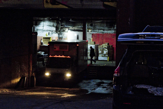
The concrete devastations of Newtown Creek, after the burning thermonuclear eye of God itself has slipped behind and become occluded by the state of New Jersey, are spooky. During daylight, they’re just a cautionary tale with occasional glimpses of terror and wonder, but after darkness settles in on the soot stained masonry offered by the warehouses, factories, and the Great Wall of Calvary Cemetery – one finds himself constantly looking over his shoulder. In the case of the furtive glance captured above, my apprehension was directed towards the spot where Review Avenue transmogrifies into Laurel Hill Blvd. nearby the old and nearly forgotten Penny Bridge. The masonry of the 1894 Penny Bridge is still extant, despite the actual span having been demolished around 1940. The first Penny Bridge, which was little more than a rope walk, opened thereabouts in 1803. It is at Penny Bridge that the presence of the spectral Blissville Banshee was first reported in 1884, as she glided across the oily waters of the Newtown Creek.
I mean – this ain’t Queens Plaza – where legions of vampires are known to drop from the steel rafters of the subways when night comes – but… Blissville after dark is just plain weird.

– photo by Mitch Waxman
It’s not just me who feels this way, either. Last Spring, a buddy of mine – who’s fairly fearless – was walking along this stretch with me at night. He began to ask insistently where we were, and opine that he was completely disoriented despite being in his native borough. Paranoid ideations began to blossom in his mind, and despite my insistence that we were on very familiar ground, anxiety began to overwhelm his reason. A distinct sigh of relief escaped his cranial breathing holes when we emerged onto Greenpoint Avenue after walking down shadow haunted Review Avenue in a generally northern direction.
Perhaps he was experiencing the sort of chronal tunnel vision that I often do.

– photo by Mitch Waxman
Could he have subconsciously known that Van Iderstine’s used to be here, or about Fleischmann’s Yeast with their stable of pneumoniac cattle. The unhealthy condition of these cattle, which attracted the attention of newspaper reporters, hygenicists, and State Board of Health Inspectors from Albany back in 1879, was attributed to being fed only fermented grain produced by the yeast brewers, which slid into their feeding troughs still steaming and straight from from the distillery process. The milk these cows produced was blueish in coloration, and nearly 1% alcohol by volume. This so called “swill milk” was not considered fit for general human consumption, as it was the lowest grade of dairy product commercially available in that era, but was considered a fitting protein source to serve to the orphans and prisoners confined on Blackwells Welfare Roosevelt Island. Nellie Bly might have spent ten days in a madhouse, but I don’t think she mentioned drinking swill milk in her famous exposé.
Van Iderstine’s, for those of you lucky enough to it have never heard of the business which used to inhabit these parts, ran a fat rendering mill hereabouts that was extant until the latter half of the 20th century. Animal parts, spoiled meat, rotten eggs, barrels of butchers blood – all were boiled down in open copper vessels here in Blissville in pursuance of the manufacture of tallow. Ghastly business, that.
– photo by Mitch Waxman
Despite the atmospheric temperatures being low enough to allow one the usage of his full armor – the filthy black raincoat and a stout hat coupled with durable clothing woven from ruggose fibers – one is always aware of his vulnerability and obsequiousness to malign elements of society due to conducting my excursions on foot. It would be a simple matter for one or two stout men to overpower one such as myself, known for his physical cowardice and nervous temperament.
Others with stronger constitution might venture into the shadows of rumor haunted Blissville, but a humble narrator chooses instead to acknowledge his lurking fear and remain naught but a passing outsider and scuttling stranger.
– photo by Mitch Waxman
Upon arriving at the inverse end of Review Avenue, a quick glance over my shoulder revealed a small group of stocky men forming up and pointing in my direction. They were clad in shadow, but the outlines of their group against the sodium lit walls of masonry revealed shapes which did not seem “right.” Discretion being the better part of valor, a humble narrator engaged the services of a passing taxi and made haste for the locked doors of HQ back in Astoria.
The world is a scary place, and the concrete devastations of Western Queens can be scarier than even the pathless deserts of Arabia, where the secrets of cities lost await discovery by the scientifically curious. What might be found… in those wisely abandoned metropolises… if occult rumors are to believed… could easily spark another dark age, and retard the forward progress of mankind – or possibly end civilization itself and condemn mankind to an endless era of ape like barbarity.
As far as the Blissville section of LIC goes – who can guess, all there is, that might be hidden down there?
Upcoming Tours and events
Calvary Cemetery Walking Tour, with Atlas Obscura – Sunday, December 10th, 11 a.m. – 1 p.m.
Explore NYC history, hidden inside sculptural monuments and mafioso grave sites, as you take in iconic city views on this walking tour, with Newtown Creek Alliance Historian Mitch Waxman – details here.
“follow” me on Twitter- @newtownpentacle
familiar rookery
It’s National Eat a Red Apple Day, in these United States.

– photo by Mitch Waxman
The holiday season arrives at Newtown Creek in a manner alien to the neighborhoods surrounding it.
Hereabouts it’s truck tires roasting on a open fire, and that ain’t Jack Frost nipping at your nose kiddo, it’s benzene. Reviewing my year end list of; all the mistakes I’ve newly made, people I’ve offended, stupid things I’ve said in public, or generally humiliated myself somehow – it occurred that I hadn’t checked in on things in DUKBO (Down Under the Kosciuszcko Bridge Onramp) in about a month.
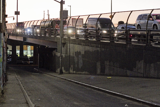
That’s the scene, above, at the spot where Review Avenue transmogrifies into Laurel Hill Blvd. at Penny Bridge, in the Blissville section of Long Island City, in the Borough of Queens.

– photo by Mitch Waxman
Long time readers of this – your Newtown Pentacle – will tell you that this bridge replacement project has been explored before.
Documenting this project has been a long standing project of mine – this 2012 post tells you everything you could want to know about Robert Moses, Fiorella LaGuardia, and the origins of the 1939 model Kosciuszcko Bridge. Just before construction started, I swept through both the Brooklyn and Queens sides of Newtown Creek in the area I call “DUKBO” – Down Under the Kosciuszcko Bridge Onramp. Here’s a 2014 post, and another, showing what things used to look like on the Brooklyn side, and one dating back to 2010, and from 2012 discussing the Queens side – this. Construction started, and this 2014 post offers a look at things. There’s shots from the water of Newtown Creek, in this June 2015 post, and in this September 2015 post, which shows the bridge support towers rising. Additionally, this post from March of 2016 detailed the action on the Queens side. Most recently, here’s one from May of 2016, and one from June of the same year. Here’s one from August of 2016, the December 2016 one, one from March of 2017 which discusses the demolition of the 1939 bridge.
Here’s a post showing what I saw during a pre opening walk through in early April of 2017, and the fanfare surrounding the opening of half of the new bridge in April of 2017, a walk through of the Brooklyn side job site in June of 2017. Here’s some night shots from early July of 2017. A series of posts focused in on the removal of the central truss of the 1939 bridge from the summer of 2017 – a timelapse, some stills, and the barging out of the truss.
Most recently, in late September of 2017, a final series of shots of the old bridge were captured in this post. Acquisition of a souvenir chunk of steel from the 1939 bridge was described in this post, and a video of the “energetic felling” of the approaches on October 1st was offered in this one. Still shots and views of the aftermath from the waters of Newtown Creek from later in the day on Oct. 1 are found in this posting, and the aftermath of the demolition as seen from Calvary Cemetery in LIC’s Blissville section in this post from October 5th.

– photo by Mitch Waxman
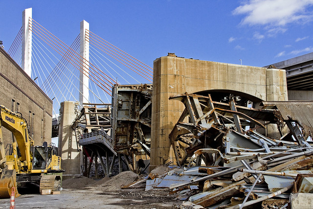
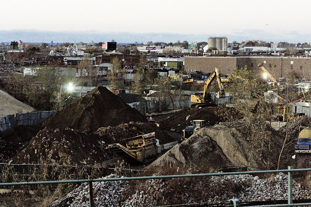
They’re still hard at work demolishing the rubble left behind by the “energetic felling” of the 1939 model Kosciuszcko Bridge at the start of October. These shots were captured from the hills of Calvary Cemetery, if you haven’t already figured that one out yet.

– photo by Mitch Waxman
The reinforced concrete piers that carried the roadway are being demolished using traditional means. That involves the yellow thingamabob being equipped with a chisel hammer, and the guy on the orange lift is spraying water on the concrete to mitigate dust.
The shots of the Queens side of DUKBO in today’s post were shot on November 17th, a Friday.

– photo by Mitch Waxman
On the following Sunday the 19th, a humble narrator scuttled over to the Poison Cauldron in Greenpoint.
That’s my pet name for the section of DUKBO that begins at Kingsland Avenue and heads east past Meeker Avenue to the National Grid fencelines at Lombardy Street. It’s ugly in the Poison Cauldron, I tell you, ugly. Things can’t “get from bad to worse” because they’re already there.

– photo by Mitch Waxman
Similar industrial demolition and scrap removal practices to those in Queens are also occurring on the Brooklyn side. Unlike the Queens side, however, I was able to walk right up to and on the job site. I even used one of the Porta Potties they had stationed to blow some internal ballast (hey, it’s a fairly long walk from Astoria).
– photo by Mitch Waxman
It is odd for me to see light in this spot… this was always an area permeated by shadows, which I now long for.
Additionally, not being chased, threatened, or harassed by the questionable managers of a local waste transfer station as to “whatchu takin pictchas of asshole, getdafukouttaherre” – said operation having been displaced by the construction activity – was not missed at all.

– photo by Mitch Waxman
The only thing going through my mind was that this scene looked like a battle had been fought here.

– photo by Mitch Waxman
I’m sure I’ll have a bit more to tell you about the Kosciuszcko Bridge shortly, as there’s supposed to be a meeting of the Stakeholders Committee coming up in early December.

– photo by Mitch Waxman
There was only so far I wanted to go, as this was and is an active demolition site.
Luckily, that’s what zoom lenses are for.

– photo by Mitch Waxman
The things you see along the Newtown Creek…

– photo by Mitch Waxman
… if you don’t take pictures of them, nobody would believe you.
How can such a place be real, and that so few people even know it exists, this omphalos of New York City?
Upcoming Tours and events
Calvary Cemetery Walking Tour, with Atlas Obscura – Sunday, December 10th, 11 a.m. – 1 p.m.
Explore NYC history, hidden inside sculptural monuments and mafioso grave sites, as you take in iconic city views on this walking tour, with Newtown Creek Alliance Historian Mitch Waxman – details here.
“follow” me on Twitter- @newtownpentacle
oddly enough
It’s National Mousse Day, in these United States.
– photo by Mitch Waxman
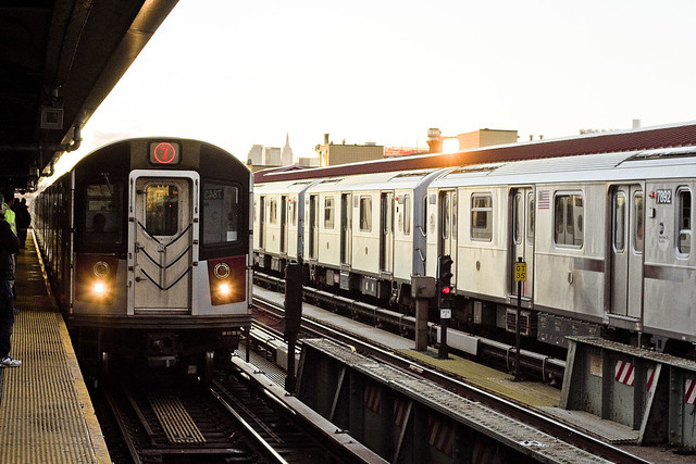
Recent endeavor found one heading in the uncharacteristic direction of eastwards. The aperitif of my evening meal was found planning the journey from the rolling hills of Astoria via the IND R line, riding it out to the Roosevelt Avenue stop in Jackson Heights, where a transfer to the IRT Flushing Line would be enacted. The menu for the night offered but one entree, and it was called “Flushing.” The filthy black raincoat was flapping about as one entered the caverns below and traveled through a Queensican tunnel within a hurtling metal box stuffed to the gills with the huddled masses. My plan worked out, a lucky break in the big City.
Often has one opined that the 7 line is the most photogenic of NYC’s subway lines, and nobody has ever risen up to challenge the assertion to my face. She’s a looker, old Lucky 7, and always reminds me of that feeling you get when arriving home and smell a a roast chicken dinner hitting the table just as you unlock the door. She’s apple pie, the bees knees, but always remember that she’s complicated. The 7 ain’t no pushover, baby.

– photo by Mitch Waxman
Whilst onboard the 7, assigning gender roles to subway lines and listening to an “old time radio” adaption of some Raymond Chandler style story on my headphones, one began to do what he does to pass the time whilst commuting. I set the camera to a fairly narrow aperture (f8) and fast shutter speed (1/1600th) and pointed it out the window. Focusing on a far away object, the “spray and pray” method of photographic endeavor was enacted. Wasn’t looking for anything in particular, mind you, other than a different point of view than you get at ground level.
The narrow aperture – by the way – involves an optical something called “hyperfocal distance,” the high shutter speed was to compensate for the movement of the train, and the ISO speed depended solely on the needs of exposure.
– photo by Mitch Waxman
I’m fairly ignorant about Flushing, as has been mentioned more than once. I know the broad stroke stuff, of course. orchards, and remonstrances, and Flushing Creek, and the railroad. I’m just not “granular” about Flushing, which is where I like to be. Haven’t yet found my usual collection of oddities, occultists, or riddled occlusions in the historical record of Flushing that one such as myself thrives on. There’s got to be a necromancy story in Flushing history, I tell you.
Did you know that there have been several UFO sightings in Flushing Meadow Corona Park, going all the way back to the 1960’s? Y’see, that’s MY kind of thing.

– photo by Mitch Waxman
That’s Flushing Creek in the shot above, which makes Newtown Creek look like Coney Island in terms of free public access to the waterfront. This is one of the spots where the “House of Robert Moses” landed heavily and then just left. The highways, the park, the airport, even the Verrazano Bronx Whitestone Bridge on the horizon are the “House of Moses.”
The Flushing Creek (aka Flushing River) was the subject of three very early Newtown Pentacle posts from 2009. These postings describe what I saw while onboard a boat heading into the waterway – one, two, and three.
– photo by Mitch Waxman
Arriving at the 7 line’s terminal stop at Main Street in Flushing, one scuttled through the throbbing masses of the downtown area. One thing I CAN tell you about Flushing is that it is packed to the gills with people, particularly in the zone around Main Street. Herds of humans staring into little rectangles of glowing glass stalk these parts, bolting forward in blind furies as soon as the street lights change, and if one is not wary he might become trampled by an incoming wall of meat.
My pal Dr. Jack, who is more conventionally known as Official Queens Borough Historian Dr. Jack Eichenbaum, lives nearby. On more than one occasion he’s pointed out how relatively narrow the sidewalks and pedestrian pathways here in Flushing are in comparison to the vehicle section of the public way. Add in a level of real estate industrial complex activity that rivals what’s happening in Long Island City, and you’ve got throngs of people and an actual pedestrian traffic problem.

– photo by Mitch Waxman
My eventual destination in Flushing was at a “Green Drinks Queens” get together at the Leaf Cafe rooftop bar.
Green Drinks Queens is being organized by my pal Erik Baard, and along a few of our mutual friends I’ve committed to attending and “doing” the events. Next one will be sometime in the first quarter of 2018, I think. I had to circulate amongst and probably annoy the folks who attended, acting as if I could carry a conversation with real people, and my main function was introducing people to other people. There was a pretty nice sized crowd, which was probably due to partnering up with the Greater Flushing Chamber of Commerce in producing the thing. The aforementioned Dr. Jack Eichenbaum was there, as were Dragon Boaters, and the “bicycle people” as well.
I did find a couple of minutes here and there to wave the camera about during the evening, and use that new mini tripod gizmo I mentioned a couple of days ago for a few long exposure shots looking westwards towards the Shining City of Manhattan.
Incidentally, I’ve been to precisely two of the new rooftop bar/lounges in Flushing, and the views from both have been absolutely spectacular – but causation is neither proof nor correlation. I now feel that I’ve a duty to visit more of them.
Upcoming Tours and events
Calvary Cemetery Walking Tour, with Atlas Obscura – Sunday, December 10th, 11 a.m. – 1 p.m.
Explore NYC history, hidden inside sculptural monuments and mafioso grave sites, as you take in iconic city views on this walking tour, with Newtown Creek Alliance Historian Mitch Waxman – details here.
“follow” me on Twitter- @newtownpentacle
evidently not
It’s National Chocolates Day, in these United States.

– photo by Mitch Waxman
An often wished for super power would be the ability to simply become invisible, or undetectable by casual observers. Since that won’t happen, barring some revolution in technology based camouflage, one instead skulks around in plain sight. To be seen by so many diminishes me.
The new NYC Ferry service has really been occupying a bit of my skulking time of late, and it has increased geographic range quite a bit. They don’t exactly advertise it, but if you buy a ticket on… say the Astoria Line… you can go the onboard snack bar and request a transfer ticket to get on one of the other lines. This essentially makes it entirely possible to get to Rockaway from Western Queens for only $2.75 by water, which kind of rocks. Generally speaking, I’m on boats doing NY Harbor or Newtown Creek tours all summer long, but in recent years I’ve been tethered to the microphone while narrating the event and seldom get a minute to wave the camera around anymore. Whereas I literally “love” this sort of tour narrator occupation, it’s been really nice for the last few weeks to keep my mouth shut and just get down to shooting whenever I’m out on the water.
Just east of the Verrazano Bridge, this little quartet of working vessels was recently observed. From the left, that’s a Miller’s Launch work boat, the Scott Turecamo tugboat, the New Hampshire fuel barge, and the cargo ship is the Nave Ariadne fuel tanker.

– photo by Mitch Waxman
One has not exactly been shooting a lot of tugboats during the last year, as I’ve grown somewhat jaded to the splendor of the maritime industrial scene in recent months. There’s only so many ways you can frame a tugboat in your shot, after all, but I just couldn’t resist the view of the Marjorie B. McAllister tug in the shot above as it transited beneath the Brooklyn Bridge with the Statue of Liberty off in the distance.
Personally, I find the Statue aesthetically pleasing. How often can you say that about a French woman who sports a 354 foot waistline as well as a four and a half foot long nose?

– photo by Mitch Waxman
A humble narrator has been known to kill an entire day in recent weeks riding back and forth on the new NYC Ferry, transiting between Rockaway and Astoria. In subsequent intervals, one plans on actually debarking the boat at a few of its mid route destinations, with a visit to the dock at Sunset Park forming into a particular set of desires.
Weather depending, sometime soon I plan on waking up early to do a sunrise transit to Rockaway. Then I’ll take the boat to Sunset Park and spend the late morning and afternoon scuttling about, followed by a setting sun trip back to Astoria.

– photo by Mitch Waxman
That’s a Bouchard tug spotted nearby Gerritsen Bay, just south east of the Verrazano Bridge. It’s an articulated fuel barge and tug, which means that there are cables full of electronic signaling equipment which run between the barge and tug in a “notch” engineered into the former, which the bow of the latter fits and connects into. It allows the crew to control the tug barge combination as if it was a cohesive and singular unit. As Bugs Bunny might have said: “dat’s Modern Design, ay?”.
Something I get, a lot, is: “Dude, how do you remember all of this stuff? You’ve just got it in your head.” I can report to you that I know less than 5% of all there is to know, just along the East River. There’s corridors on the water – Newtown Creek for instance – that I know a LOT about, but even there there’s always something new to glean.
I learn something new every single day.

– photo by Mitch Waxman
I’m still figuring out the block I live on in Astoria, after all.
It’s been an odd few weeks here in the ancient village. The armies of chaos who transit through here on a regular basis have been shifting around a bit in size, character, and sort of late. Just heard a disturbing story last night which saw a female friend of mine show up at HQ with two black eyes, another last week from a local Pizza shop owner who found his shop in the middle of what he described as a “Mexican riot” at two in the morning, and large groups of teenagers have been riding bicycles together. Recently, I saw a baby who had one eyebrow that stretched from eye to eye right over the nose, and a pair of dogs who were wearing shoes and coats. I also saw someone walking a cat on a leash.
The world is a scary place, but I’m ok because I’m hiding behind a camera where nobody can see me.
Upcoming Tours and events
Calvary Cemetery Walking Tour, with Atlas Obscura – Sunday, December 10th, 11 a.m. – 1 p.m.
Explore NYC history, hidden inside sculptural monuments and mafioso grave sites, as you take in iconic city views on this walking tour, with Newtown Creek Alliance Historian Mitch Waxman – details here.
“follow” me on Twitter- @newtownpentacle
reconised from
It’s National French Toast Day, in these United States.
 – photo by Mitch Waxman
I was on my way to the ferry one recent morning, but had to make a quick stop nearby Queens Plaza. Lotsa running around, me. The light bouncing around in Queens Plaza caught my eye, however.
That’s the Rosenwasser Bros. factory at the right hand side of the shot, all illuminated by one of the shiny mirror box condo towers being built in Queens Plaza. It’s Orchard street, by the way, corner of Jackson Avenue. The Rosenwassers were magnates in the rag trade who started out – like many Jewish garment tycoons – in the shirtwaist industry of Lower Manhattan. Running what 21st century eyes would process as a sweatshop, they accumulated enough money to set up a large industrial combine in Queens shortly after the Queensboro bridge opened in 1909, and enjoyed several military as well as civilian contracts. By 1913, they were an established and well known Queensican company run by its President, Morris Rosenwasser, which offered baseball cleats (sold under Babe Ruth branding) and scouting equipment to retailers.
At its height in 1918, the Rosenwasser Company employed some 2,500 people. During the First World War, the firm enjoyed several valuable contracts with the Federal Government. The factory in Queens Plaza turned out an average of 6,000 pairs of shoes a day, 15,000 pairs of leggings, and an undetermined number of canvas gas masks, rucksacks, and other commodities for the war department. A so called “open shop,” the Rosenwassers were prime movers in a case (Rosenwasser Bros. Inc. v. Pepper et al, NYS Supreme Court October 1918) which defined the rights and limitations of organized labor during wartime for a generation.
Who knew?
 – photo by Mitch Waxman
The Welfare Island Bridge opened, officially, on May 18, 1955. We know it as the Roosevelt Island Bridge.
Like the nearby Pulaski Bridge over Newtown Creek, which was erected in the same era, Frederick H. Zurmuhlen of the Dept. of Public Works oversaw the design and construction of the Welfare Island Bridge. One of the unsung men who built the modern city, Zurmuhlen served under three mayors and one Robert Moses.
The Welfare Island Bridge, known to modernity as the Roosevelt Island Bridge, has recently undergone a refurbishment and makeover. Much was made of the cosmetic improvements to the span, but the reality of the investment was a determination that in case of a seismic event – which the City of New York is long overdue for – the Bridge would suffer catastrophic damage. A massive earthquake is one of the unspoken horrors which the City government had been quietly planning for during the twelve year tenure of Michael Bloomberg, something which that Mayor’s office would be applauded for were it more widely known. A tip of the hat goes out to the municipal engineers and planners for both their discretion and the secretive work which they had been performing. Of course, that sort of thing went out the window when the Dope From Park Slope showed up.
As far as the current Mayor… he’s busy trying to build “affordable” waterfront housing that starts at $3,700 for a one bedroom. A highly technical description of NYC’s earthquake risk factors, as prepared and offered in 1998 by the NY State DOT, can be accessed here.
 – photo by Mitch Waxman
These shots were captured from the NYC Ferry’s Astoria line, which is one of the few things that I consider the current Mayor as having done well in his first term. Of course, I can tell you that I’d been hearing about this expansion of the East River Ferry service in harbor circles for years, and can quietly point you at certain employees of the NYCEDC who handed the current Mayor a finished plan for him to put his name on the day he got into office, but regardless – if you haven’t ridden the new ferry from Astoria yet, what are you waiting for? You paid for it, you might as well use it. The experience is pretty cool, and it’s only $2.75.
Pictured above is a section of the Big Allis power plant, with the sapphire megalith of LIC peeking through some of its works. Big Allis supplies about 16% of NYC’s electricity, and was the first million kilowatt generating facility in the entire country. Built at the behest of Consolidated Edison, Big Allis (aka Ravenswood Number Three) first went online in 1965. Upon activation, the
dynamos of Big Allis were reduced to slag by the heat issuing from within its massive, natural gas driven turbines. Six months later, a rebuilt system managed to withstand a full hour and twenty seven minutes of these cosmic forces before it too went out of commission for a further four months. The problem was diagnosed by experts and teams of engineers being caused by a malfunctioning bearing which was producing concatenation and vibrations.
Did you know that Big Allis was originally meant to be a nuclear plant?
 – photo by Mitch Waxman
That’s the Queensboro Bridge, pictured above, looking back along the shoreline of Queens at the border of Hunters Point and Ravenswood. The borders between these areas are always hazy, and are often the subject of debate amongst those with an appreciation for times past and things forgotten. I’ve coined the term “angle” to describe these blended neighborhoods; Blissville and West Maspeth, Woodside and Sunnyside, Astoria and Elmhurst etc. In the case of Blissville and Maspeth, the Koscisuzcko Bridge sits on the exact border between the two… but where does Woodside start and Sunnyside end? Even worse, where does Winfield fit into the puzzle? Angles, I tell you, angles.
At least along the East River, things are fairly simple – Astoria, Ravenswood, Hunters Point – from north to south.
 – photo by Mitch Waxman
You’ve got a lot of “sub zones” as well in those East River neighborhoods in Queens, the Astoria Ferry Line leaves from Lawrence or Astoria Point at Hallets Cove, and the “north side” ferry dock pictured in LIC above is found alongside future superfund site Anable Basin. A hundred years ago, the area where all of those shiny new residential towers pictured above sit in modernity was once the property of the Standard Oil Company and hosted a pretty large parcel of petroleum oriented equipment, chemical and paint factories, and one or two large oil canning operations.
There was also the Ward and Co. Oil and Lard mill back there, which is one of those late 19th and early 20th century industrial operations whose occupation and business… well… common usage would describe it as “Dickensian.”
 – photo by Mitch Waxman
It’s always difficult to do justice to the East River.
The bridges, the history… it’s a maritime corridor in which so much happened that it’s often hard to believe. In many ways, it’s where American capitalism “figured itself out.” In the 18th and early 19th centuries, it’s where the slave ships were built over on the Manhattan side. It’s where the financial powers which would become “Wall Street” began issuing the credit documents and bills of laiding recognized by the European colonial powers, where the first modern steel hulled and steam powered ships were built, and where profiting from the “five black arts” were perfected and practiced.
Upcoming Tours and events
Calvary Cemetery Walking Tour, with Atlas Obscura – Sunday, December 10th, 11 a.m. – 1 p.m.
Explore NYC history, hidden inside sculptural monuments and mafioso grave sites, as you take in iconic city views on this walking tour, with Newtown Creek Alliance Historian Mitch Waxman – details here.
“follow” me on Twitter- @newtownpentacle
