Posts Tagged ‘newtown creek’
Magic Lantern Show

– photo by Mitch Waxman
It is needless to say, of course, is that my magic lantern is digital. In the dawn of the age of photography, journeyman shooters would travel all around the world, or to corners of the City which the genteel upper crust would eschew- and capture images of titillating subjects for the entertainment and evangelization of the moneyed classes who would otherwise never encounter such things. Jacob Riis and Matthew Brady come to mind, and whereas your humble narrator would never allow himself to invoke those names for fear of the vast hubris it would call crashing down about my ears, a belief nevertheless persists around Newtown Pentacle HQ that such an exhibition can still find a modern audience.

– photo by Mitch Waxman
Just under an hour long, this Magic Lantern Show about Newtown Creek is personally narrated, and transports the viewer to every corner of the Newtown Creek- every tributary and street end, on the water and above it, and is presented in the idiosyncratic and off beat manner which has become familiar to regular readers of this- your Newtown Pentacle. It attempts to explain certain core questions in under an hour which have been repeatedly presented to me over the last couple of years, and the entire talk is illustrated with both my photography and historical researches and documents:
- What exactly do you mean by the “Newtown Pentacle”?
- When did the Newtown Creek begin to matter?
- Why should I care, how does the Newtown Creek affect me, as I live in Manhattan?
- Where exactly is this place?
- Who is responsible for this mess, and exactly who is it that’s going to clean it up?
- How can I get involved and help my community revitalize and or restore the Newtown Creek?
– photo by Mitch Waxman
The entire evening will cost you a mere sawbuck, or $5 as it’s referred to in modernity (and I’m not altogether certain what the deal is if you’re already a GAHS member, you’d be best served by checking in with them), and will be presented at the Greater Astoria Historical Society on June 6th, 2011 at 7p.m. I’d love to see you there, and there will be a question and answer period after the show, in which I’ll endeavor to respond to any random question from the audience. Luckily, GAHS will be there, should my knowledge fall short. Come one, come all.
Believe it or not, this still isn’t the BIG announcement. Await with baited breath the next thrilling installment of this- your Newtown Pentacle.
Bernie

– photo by Mitch Waxman
Bernard Ente died this morning. Master photographer, historian, community leader, advocate for Newtown Creek and all things maritime, Bernie is survived by his wife and daughter- who for the time being, ask Bernie’s many friends to abstain from attempts at contacting them. They know and appreciate that you want to reach out, but require some private time during which to come to terms with their loss. As does the entire City, for losing Bernie from our collective community is a body blow.
Bernie was one of the guiding lights at Working Harbor Committee, Newtown Creek Alliance, and one of my very favorite people. His knowledge of the history of New York was second to none, and Bernie was the one who encouraged and nurtured an entire generation of bloggers and photographers to step forward and publish (including your humble narrator).
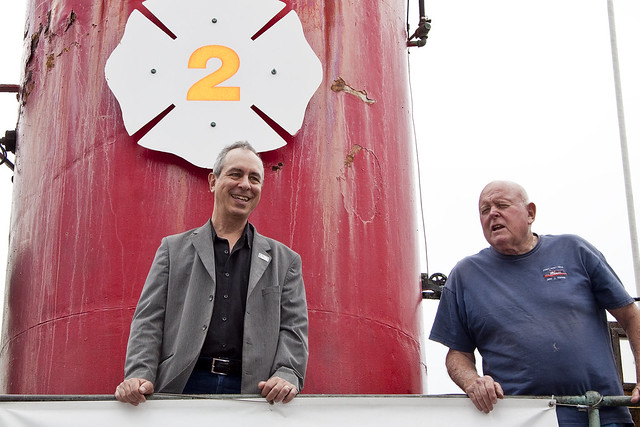
– photo by Mitch Waxman
Bernie would call me up late in the evening and ask “So, what are you doing tomorrow?”.
No matter what, I’d say “nothing”, and resolve to clear my schedule or call in sick to work because when Bernie called there was an adventure to be had. Whether it was riding on a Fireboat, or taking a group of tourists on a walking tour of some distant and long forgotten locale, or showing off New York Harbor to a class of inner city kids- it was always an adventure. His sense of humor was legendary, and he was one of the most honest people I’ve ever met- possessed of an incontrovertible sense of “right and wrong”.
More on Bernie will be said in the coming days, but I’m a bit overcome by the loss of my friend at the moment.
delicate individual

– photo by Mitch Waxman
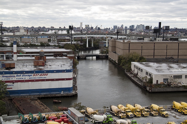
Less than 2 weeks ago, I was wandering around in Greenpoint, heading for the street address of Continental Iron Works- the ship yard where the USS Monitor was laid down at West St. between Calyer and Quay near the Bushwick inlet. It was on Greenpoint Avenue when the shot above was stumbled across, close to where Newell crosses (or perhaps crossed) it. The big attractions in this neighborhood are the Newtown Creek Waste Water Treatment Plant and the Greenpoint Avenue Bridge, of course, but the acquisition of certain geographic knowledge is critical to several of my irksome studies at the moment (and even if the site has been obliterated in modernity), the efficacy of certain… theories of mine… depends on direct observation.

– photo by Mitch Waxman
While wandering about, the attention of several itinerant laborers became focused upon me, and although their jocular suggestions about destinations for my camera were titillating, my nervous nature took control over my ambitions for the afternoon and an effort was made to remove myself from their company in the fastest manner possible. The step of a coward is a quick one, but this odd truck trailer was spotted and demanded attention. I’m positive that someone else got this before me, likely Ms. Heather, but for a single moment your humble narrator stood tall to bring you its amusing visage.
…Also, I didn’t know the 7 train ran in Greenpoint…
ruthless conquest

– photo by Mitch Waxman
Terrible in its grandeur, the Newtown Creek Wastewater Treatment Plant dominates the landscape around Greenpoint’s border with Long Island City. The Nature Walk which skirts part of its shoreline with Newtown Creek affords rare and untrammeled access to the industrial waterway, and provides an interesting vantage point to the traveling photographer.

– photo by Mitch Waxman
All sorts of artistic flourishes adorn the Nature Walk, one of which is pictured above that purports to show the primeval Newtown Creek and the vast meanderings of it’s course. The bottom of the frame represents the East River, and the coiling shape to the left is Dutch Kills. Note that the original course of the waterway was far reaching, and extended far beyond the modern bulkheads. In olden times, this area was referred to as “waste lands” while in modern times we call such territory “coastal wet lands”.

– photo by Mitch Waxman
Still under construction, the section of Whale Creek hidden from view is where the sludge handling docks will be. One can expect the enormous sludge tank at the East River on Commercial Street to be demolished when these are done, and opportunities to photograph the City’s fleet of Sludge Boats up close and personal are sure to abound.

– photo by Mitch Waxman
Without a hint of irony, this section of the Nature Walk is called the Scent Garden, and it is well stocked with (often indigenous) aromatic plantings. It extends back a few hundred yards, and seems to be the spot where workers at the plant go to on breaks as evinced by cigarette butts and garbage pails full of fast food packaging. Interesting spot, but not so much visually.

– photo by Mitch Waxman
Across the Newtown Creek on the Queens side is the “big show”. The mouth of Dutch Kills is occluded by a non functioning swing bridge and a static truss bridge. I’ve been told that should the swing bridge need to be opened, it is accomplished by using Tow Trucks of the sort used for heavy vehicles which winch stout steel cables temporarily attached to the structure. Your humble narrator hasn’t observed this himself, so it is hearsay- albeit from a quite reliable source.

– photo by Mitch Waxman
The Newtown Creek Dock, once the Night Soil and Offal Dock and later the LIRR Manure dock, is currently under a century long lease to SimsMetal. A global player in the recycling trade, Sims is contracted by the DSNY to receive several of the materials they collect for processing and disposal. They shred paper and plastic, shatter glass, and sunder metal.
I can sit and watch this operation go for hours at a time.

– photo by Mitch Waxman
I would be keen to actually visit Sims, but I’ve been told that this is another one of the VERY dangerous places to be on Newtown Creek. That giant pile of metal that is being sorted used to be automobiles, and the tiny toy dump trucks in the background are actually oversized wreckers. Enormous machines moving at industrial speed, with vast tonnages of metal being shredded? Not a place for a civilian, or so I’m told.
Still…
hoary and sinister

– photo by Mitch Waxman
As mentioned in prior postings, your humble narrator has been making a dedicated effort to visit and revisit certain sites along the Newtown Creek to which access was restricted during the long and icy winter. This springtime survey is referred to as “walking the beat” around HQ, although it really should be described as “scuttling the beat”. On March 19th, my camera and I found ourselves at the Newtown Creek Wastewater Treatment Plant‘s Nature Walk.
Click here for more on the Nature Walk

– photo by Mitch Waxman
A surprisingly beautiful space, the Nature Walk is the safest and one of the most accessible vantage points along the infamous industrial waterway. Despite it’s relative remoteness, at the end of Paidge Avenue past the corner of Provost Street, people do find their way here. For some reason, I always find this surprising.

– photo by Mitch Waxman
The Newtown Creek has several access points, but most are pestilential street ends bordering industrial sites which are defended by dull eyed watchmen and aggressive private security guards. A few of them actually take you to the water’s edge, but you end up standing in contaminated mud amidst the rusting hubris of 150 years of breakneck industrial growth. The nice bit about the NCWWTP Nature Walk is that you are actually fairly safe (well… as safe as you ever are around the Creek…) and that it provides gorgeous wide open panoramas for the journeyman photographer.

– photo by Mitch Waxman
The tributary which the sewer plant adjoins is Whale Creek. Once upon a time, this section of Greenpoint was the center of the lamp oil refinery trade, and said lamp oil was sourced from whale oil. Just down the main waterway from here were the shipyards of Neziah Bliss (and others) which supplied, augmented, and repaired the ships of New York’s whaling fleet. Additionally, the African slaves of Greenpoint and Newtown were known to join the crews of these ships, as 19th century whalers didn’t care about what color you were, just how hard you could work and how long you might survive.

– photo by Mitch Waxman
The planters you see here are blocking the kayak launch, part of the controversial decision on the part of the City fathers to disallow boats to access the Creek from City property (obviously for liability reasons, in the wake of the Superfund announcement by the Federal Government). That decision has since been countermanded, and the launch is scheduled to reopen at the start of the “season” which greatly enhanced the happiness of those redoubtable kayakers emanating from the Long Island City Boathouse.

– photo by Mitch Waxman
Personally, you couldn’t get me to interact with the water here even at gunpoint, but past postings have described the vast physical cowardice which cripples me. I can tell you, from everything I know about the Creek, that the water quality here isn’t “horrible”. It’s a little dirtier than the East River in this section, except after a rain event, which demands an interval of time to allow the bacterial and colorectal dumping of Combined Sewer Outfalls to dissipate. Luckily, radiation from the burning thermonuclear eye of God itself destroys most of these pathogens within a few days, and the focus shifts from bacterial to chemical contamination.
You are insane (or a Viking), though, if you spend much time beyond the Greenpoint Avenue Bridge or in Dutch Kills, Maspeth Creek, and especially English Kills. Lots of people are thusly “insane” however, and hardily survive the experience- so perhaps I’m being over cautious.
Time will tell, and cancer is patient.

– photo by Mitch Waxman
Tomorrow, we’ll talk about the rest of the Nature Walk, and some of it’s more interesting features, but while viewing the shield wall of the Shining City with it’s titan blocks hurled at the sky- I noticed one of those small details which often escapes casual notice. Note the fencing in the lower left corner of the shot above, and the white placards affixed to it.
One of my pet peeves about the Newtown Creek watershed can be expanded upon here.

– photo by Mitch Waxman
Three bits of signage, and I am assured by powers and potentates alike that these are strictly temporary, admonish and inform users of the waterfront access point about the esoteric dangers which one might encounter along the Creek. When an earlier posting at this, your Newtown Pentacle, warned the cadre of boaters docked at the Vernon Avenue Street end that they were placing themselves in “Mortal and Existential danger“- this is the sort of thing I was talking about.

– photo by Mitch Waxman
My pet peeve, as it were, is that these signs are difficult to notice and written in English. Observations of who it is that actually fishes in Newtown Creek have revealed that it is mostly Spaniard and Slavic anglers that ply these waters- and the populations which line its Brooklyn banks are demographically disposed toward demonstrating literacy in the Spanish or Polish languages. Logic dictates, therefore, that this would be an excellent place for a multi-lingual bit of municipal signage.
As mentioned, I’ve been informed that such multilingual signage is “in the works”.

– photo by Mitch Waxman
The English issue is something that I’m increasingly concerned about as we move into the Superfund era, and one that I’ve raised at the Newtown Creek Alliance meetings. If someone reading this posting is fluent in either Polish or Spanish, and wishes to “get involved”- please contact me here or swing over to the NCA website to find out more about the organization. My particular focus within the group is Queens, of course, but I see the communities surrounding the Creek as being more involved with each other (Long Island City and Greenpoint are ultimately one entity, despite political sophistry. Back in the day, they lived in Greenpoint and worked in LIC) than the neighborhoods surrounding them on the landward side.
Come to think of it, the Eels that this sign cautions against might explain those eyeless wriggling things that I’ve observed in Maspeth Creek- hmm.

– photo by Mitch Waxman
Note: The following is a personal viewpoint, and doesn’t reflect the policies of any organization-
The world only makes sense when you force it to do so. Titanic forces and entities are on the move around the Newtown Creek, and the season of tumult and change upon the ancient waterway has begun. Whether the final shape of the place will be determined by outsiders or the community itself is ultimately up to us. The truth of Newtown Creek is that it is still one of the great economic engines of New York City, and one of the few places where someone without a collegiate degree can earn a decent living by the sweat of his brow. Do we want to lose this in the name of providing anchorages for some rich guy from Manhattan to park his yacht? What do you want the Newtown Creek to look like 20 years from now?
Paraphrasing Roger Waters- Are we destined to become a nation of waitresses, and waiters?


