Posts Tagged ‘ny harbor’
gleaming vividly

– photo by Mitch Waxman
An unusually personal posting today-
A continuing fascination with the complexities of maritime photography has taken up quite a bit of my summer in 2011. Tugboats, in particular, demand attention whenever I’m on or near the water. It probably has to do with having recently sold a couple of tug shots to the NY Times, illustrating an article in the weekender section profiling the Working Harbor Committee.
When you get paid for something you enjoy doing, life attains symmetry and seems to have a purpose, especially when the people writing the check are “the paper of record”.

– photo by Mitch Waxman
As has been my habit since childhood, late summer is when I assess “how it’s going”, figure out what isn’t working in my life and try to formulate a plan to get “back on track”. It’s been a great few months: working with Forgotten-NY and Greater Astoria Historical Society on their ambitious “2nd Saturday” series of tours, assisting the Working Harbor Committee with their multitudinous tours and events, helping design and produce an event for the New York City Centennial Bridge Commission, and conducting my own boat tours of Newtown Creek for Working Harbor and Metropolitan Waterfront Alliance’s City of Water Day. I’ve also presented the Magic Lantern show three times this summer- at Greater Astoria Historical Society, City of Water Day, and at a DEP event.
Additionally, Newtown Creek Alliance’s various events, presentations and public meetings have kept me quite busy. However, in the midst of working with all these wonderful people, my own operation and schedule has been damaged by inattention.

– photo by Mitch Waxman
One thing which is foremost in my mind, and which will be rectified in the coming weeks and months as we slouch toward fall and winter, has been the irregular schedule of postings here. Apologies are offered, contradicting my normal credo of “never complain, never explain”, but this blog is essentially a one man operation (although special kudos go out to Our Lady of the Pentacle and Far Eastern Correspondent Armstrong for unbelievable effort and support). Massive effort is underway to resume a normal and regular schedule of postings.
There will be one more HUGE announcement coming about a Newtown Creek event I’ll be offering in October, but I’m contractually obligated to not be more specific about it than that.
In short… Back in session.
Happy Birthday, Kosciuszko Bridge

– photo by Mitch Waxman
A virtual guarantee is offered that this is the only posting you will see today commemorating and wishing the Kosciuszko Bridge a happy 72nd birthday. Some 26,298 days ago, Robert Moses saw the first link in a crazy idea of his which would one day be called the “Brooklyn Queens Connecting Highway” open for business.

– photo by Mitch Waxman
The Meeker Avenue Bridge opened on August 23rd, 1939 (renamed in 1940 as The Kosciuszko Bridge) – some 631, 152 hours ago. It was promised to allow easy egress to the World’s Fair, and was a showpiece project for the Great Builder.

– photo by Mitch Waxman
From a Newtown Pentacle posting of December 8, 2010– in which the big K was described as thrice damned:
Damned Once- The Kosciuszko Bridge catches radio frequency emissions from several nearby commercial radio broadcast antennas. A lot of it.
Whatever knows fear burns at The Kosciuszko Bridge’s touch.
Damned Twice- The Kosciuszko Bridge is at extreme risk in the eventuality of a seismic event. The Brooklyn pier actually sits on the Creek bed, some 6 meters below grade, but the Queens side is anchored on piles driven into the mud. The hard soil around Queens Plaza will merely shake, but the land surrounding the Newtown Creek will liquify.
Damned Thrice- The Kosciuszko Bridge once had pedestrian walkways, but they were removed in 1961. Can you imagine what kind of photos would be possible on a pedestrian walkway 124 feet over the Newtown Creek?
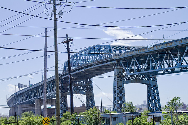
– photo by Mitch Waxman
Like many things and people who are 72 years old, the Kosciuszko Bridge is not long for this world. Why not raise a glass to it tonight, and acknowledge its long service to the City?
Click here for a sentimental slideshow of the old girl from the last couple of years
irrepassable gate
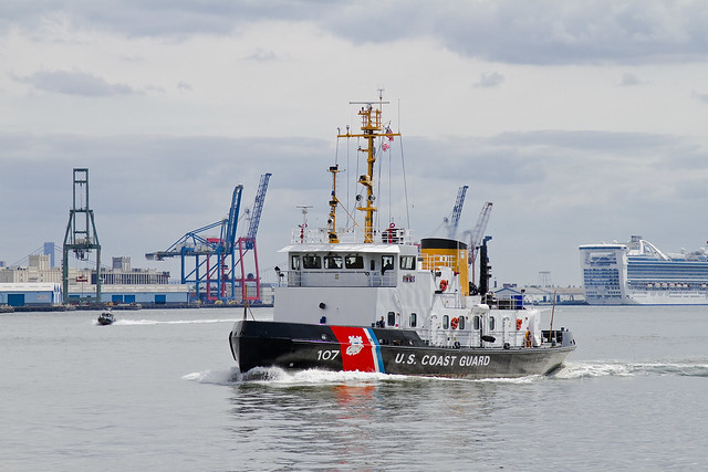
– photo by Mitch Waxman
Awhile back, I posted this series of shots to Flickr, and an enigmatic shipping enthusiast from the vast interweb hive mind immediately commented “140′ Bay Class Icebreaking Tug USCGC PENOBSCOT BAY WTGB-107 homeport Bayonne, NJ.”.
From wikipedia
The USCG Bay-class icebreaking tug is a class of 140-foot (43 m) icebreaking tugs of the United States Coast Guard, with hull numbers WTGB 101 through to WTGB 109.
They can proceed through fresh water ice up to 20 inches (51 cm) thick, and break ice up to 3 feet (0.91 m) thick, through ramming. These vessels are equipped with a system to lubricate their progress through the ice, by bubbling air through the hull.

– photo by Mitch Waxman
When focusing in on this ship, I just thought it looked cool. Turns out that this class of vessels has a long and storied past.
Here’s a Coast guard shot of Penobscot Bay in action during the winter…
Here’s the official story, courtesy United States Coast Guard:
from uscg.mil
The 140-foot Bay-class Cutters are state of the art icebreakers used primarily for domestic ice breaking duties. They are named after American Bays and are stationed mainly in Northeast U.S. and Great Lakes.
WTGBs use a low-pressure-air hull lubrication or bubbler system that forces air and water between the hull and ice. This system improves icebreaking capabilities by reducing resistance against the hull, reducing horsepower requirements

– photo by Mitch Waxman
Note: I should mention that members of the USCG have offered me very good, yet unofficial, advice on appropriate maritime footwear in the past- which may render some personal bias on my part for the organization.
The USCG also maintains a short history page on this ship, which can be accessed here.
the dark moor

– photo by Mitch Waxman
Lucid and unwholesome, witness this sky flung perspective of the backbone of New York City- vantaged from several hundred feet above the Newtown Creek and it’s little known tributary- Whale Creek, and high atop the digester eggs of the Newtown Creek Wastewater Treatment Plant.
Gaze in wonder at the majesty of western Queens.
Additionally, click here to see this view reversed, and witness the parallel horizon of infinite Brooklyn.

– photo by Mitch Waxman
That’s the Thomas D. Witte tugboat maneuvering a barge into position at the SimsMetal dock, and the rusty crossing in the background is the non functioning swing bridge which spans the larger Queens side tributary of Newtown Creek called Dutch Kills.

– photo by Mitch Waxman
That’s the LIRR moving along the ancient rail tracks which have blessed the industries and cursed the residents of this area since the early 19th century. The general area that the locomotive track is passing through, employed to this very day by petrochemical interests, is the former Queens location of Standard Oil at Newtown Creek.

– photo by Mitch Waxman
In the distance, from left is Lindenthal’s magnificent Queensboro, the Big Allis power plant, the omnipresent Sapphire megalith, the high flying Long Island Expressway, and a substantial portion of the vast industrial quarters of Long Island City which I call “The Empty Corridor“.
betwixt the horns

– photo by Mitch Waxman
Call me paranoid, but the Fireboat Three Forty Three seems to be following me around. Everywhere I go these days, there it is. Has anyone ever been stalked by a crewed ship on its shakedown cruise?
Perhaps.
from wikipedia
140-foot, 500-ton, $27 million dollar boat will be the country’s largest fireboat with a maximum speed of 18 knots. The Three Forty Three will provide the FDNY with the latest technology available for Marine vessels, including the capability of pumping 50,000 gallons of water per minute; nearly 30,000 gallons more than its predecessor. The need for this increased pumping capacity was graphically displayed as FDNY’s existing fireboats supplied the only water available for many days after the September 11, 2001 attack on the World Trade Center. However, the technological advances of these new boats do not end there. The boat’s original design by Robert Allan Ltd. of Vancouver, B.C. will catapult FDNY’s Marine Division into the 21st century and beyond.
Because of the very real threat of additional terrorist attacks after 9/11, the boats will also be capable of protecting firefighters from Chemical, Biological, Radiological, Nuclear agents (CBRN). While performing in any of these hostile environments, the crew will be protected in a pressurized area that will also have its air supply filtered by special charcoal and HEPA filters. Assistance on the design of the CBRN system was provided by engineers from the U.S. military’s Joint Program Executive Office for Chemical and Biological Defense and Naval Sea Systems Command. United States Navy.

– photo by Mitch Waxman
Day two of a particularly interesting summer cold, and as you’re reading this (assuming it’s daylight) your humble narrator is most likely aboard a Circle Line and talking on the microphone describing the sights and hidden meanings of NY Harbor to a group of 700 Octa, Nona, and Centenarians.
Such odd moments in life are, of course, owed to the Working Harbor Committee and the Borough President of Manhattan, who makes money available for his constituents in nursing homes to “get out for a day”.
from mbpo.org
Scott M. Stringer, a native New Yorker, is the 26th Manhattan Borough President.
Since taking office at the start of 2006, he has dedicated himself to making Manhattan more affordable, livable…and breathable – preserving the sense of neighborhood for the 1.6 million residents of what is best known as a world capital of culture and commerce.
The foundation for much of the borough president’s work is the change he’s brought to Manhattan’s community boards. Energizing these formal institutions of neighborhood democracy was a top priority of Stringer’s upon becoming borough president. A new merit selection process, combined with an infusion of badly needed resources – such as dedicating to each board a graduate student from the city’s architecture and planning schools – has served to strengthen the voice of Manhattan’s neighborhoods in debates over city planning.

– photo by Mitch Waxman
It was actually a recent Working Harbor trip, this time a program for kids in which representatives of certain maritime organizations like Coast Guard and Port Authority commune with a group of “city kids” onboard a boat, which had brought me to the Hudson on the day these shots were taken. The goal is to introduce to them the idea of a career on the harbor, something not often considered in the wilds of central Brooklyn or Queens.
Another maritime engagement would require me to be at South Street Seaport in the evening, and I had a few hours to kill so I decided to walk from 42nd street to South Street the long way, around the Battery.
from wikipedia
Battery Park is a 25-acre (10 hectare) public park located at the Battery, the southern tip of Manhattan Island in New York City, facing New York Harbor. The Battery is named for artillery batteries that were positioned there in the city’s early years in order to protect the settlement behind them. At the north end of the park is Castle Clinton, the often re-purposed last remnant of the defensive works that inspired the name of the park; Pier A, formerly a fireboat station; and Hope Garden, a memorial to AIDS victims. At the other end is Battery Gardens restaurant, next to the United States Coast Guard Battery Building. Along the waterfront, ferries depart for the Statue of Liberty and Ellis Island, and there is also a New York Water Taxi stop. The park is also the site of the East Coast Memorial which commemorates U.S. servicemen who died in coastal waters of the western Atlantic Ocean during World War II, and several other memorials.
To the northwest of the park lies Battery Park City, a planned community built on landfill in the 1970s and 80s, which includes Robert F. Wagner Park and the Battery Park City Promenade. Together with Hudson River Park, a system of greenspaces, bikeways and promenades now extend up the Hudson shoreline. A bikeway might be built through the park that will connect the Hudson River and East River parts of the Manhattan Waterfront Greenway. Across State Street to the northeast stands the old U.S. Customs House, now used as a branch of the National Museum of the American Indian and the district U.S. Bankruptcy Court. Peter Minuit Plaza abuts the southeast end of the park, directly in front of the South Ferry Terminal of the Staten Island Ferry.

– photo by Mitch Waxman
In planning my route, however, I forgot to factor in the Freedom Tower and the 911 site, which is something I normally avoid like the plague. As a rule, I stay away from this subject, don’t discuss my dead friends who were Port Authority cops or Fire Fighters, and don’t engage in conversational speculation about the event with either the “Truthers” or the conspiracists.
On the other hand, I think that naming a Fireboat “Three Forty Three” is extremely appropriate while the term “Freedom Tower” is just silly and smacks of bad comic book writing.
from wikipedia
One World Trade Center (1 World Trade Center), more simply known as 1 WTC and formerly known as the Freedom Tower, is the lead building of the new World Trade Center complex in Lower Manhattan in New York City. The tower will be located in the northwest corner of the World Trade Center site, and will occupy the location where the original 8-story 6 World Trade Center once stood. The north side of the tower runs between the intersection of Vesey and West streets on the northwest and the intersection of Vesey and Washington streets on the northeast, with the site of the original North Tower/1 WTC offset to the southeast. Construction on below-ground utility relocations, footings, and foundations for the building began on April 27, 2006. On March 30, 2009, the Port Authority confirmed that the building will be known by its legal name of ‘One World Trade Center’, rather than the colloquial name ‘Freedom Tower’. Upon completion, One World Trade Center will be the tallest building in the United States, standing at a height of 1,776 feet (541.3 m), and among the tallest buildings in the world. It will be taller than the Empire State Building, and will be completed by the beginning of 2014.


