Posts Tagged ‘Staten Island’
H.P. Lovecraft’s “The Festival”

– photo by Mitch Waxman
text quoted from H.P. Lovecraft’s “The Festival”, courtesy wikisource, where you can read the whole story
I was far from home, and the spell of the eastern sea was upon me. In the twilight I heard it pounding on the rocks, and I knew it lay just over the hill where the twisting willows writhed against the clearing sky and the first stars of evening. And because my fathers had called me to the old town beyond, I pushed on through the shallow, new-fallen snow along the road that soared lonely up to where Aldebaran twinkled among the trees; on toward the very ancient town I had never seen but often dreamed of.

– photo by Mitch Waxman
It was the Yuletide, that men call Christmas though they know in their hearts it is older than Bethlehem and Babylon, older than Memphis and mankind. It was the Yuletide, and I had come at last to the ancient sea town where my people had dwelt and kept festival in the elder time when festival was forbidden; where also they had commanded their sons to keep festival once every century, that the memory of primal secrets might not be forgotten. Mine were an old people, and were old even when this land was settled three hundred years before. And they were strange, because they had come as dark furtive folk from opiate southern gardens of orchids, and spoken another tongue before they learnt the tongue of the blue-eyed fishers. And now they were scattered, and shared only the rituals of mysteries that none living could understand. I was the only one who came back that night to the old fishing town as legend bade, for only the poor and the lonely remember.

– photo by Mitch Waxman
Then beyond the hill’s crest I saw Kingsport outspread frostily in the gloaming; snowy Kingsport with its ancient vanes and steeples, ridgepoles and chimney-pots, wharves and small bridges, willow-trees and graveyards; endless labyrinths of steep, narrow, crooked streets, and dizzy church-crowned central peak that time durst not touch; ceaseless mazes of colonial houses piled and scattered at all angles and levels like a child’s disordered blocks; antiquity hovering on grey wings over winter-whitened gables and gambrel roofs; fanlights and small-paned windows one by one gleaming out in the cold dusk to join Orion and the archaic stars. And against the rotting wharves the sea pounded; the secretive, immemorial sea out of which the people had come in the elder time.

– photo by Mitch Waxman
Beside the road at its crest a still higher summit rose, bleak and windswept, and I saw that it was a burying-ground where black gravestones stuck ghoulishly through the snow like the decayed fingernails of a gigantic corpse. The printless road was very lonely, and sometimes I thought I heard a distant horrible creaking as of a gibbet in the wind. They had hanged four kinsmen of mine for witchcraft in 1692, but I did not know just where.

– photo by Mitch Waxman
As the road wound down the seaward slope I listened for the merry sounds of a village at evening, but did not hear them. Then I thought of the season, and felt that these old Puritan folk might well have Christmas customs strange to me, and full of silent hearthside prayer. So after that I did not listen for merriment or look for wayfarers, kept on down past the hushed lighted farmhouses and shadowy stone walls to where the signs of ancient shops and sea taverns creaked in the salt breeze, and the grotesque knockers of pillared doorways glistened along deserted unpaved lanes in the light of little, curtained windows.
Happy Birthday, Bayonne Bridge

– photo by Mitch Waxman
A Sunday, the first day that the Bayonne Bridge opened for use to the general public was 28,856 days ago, on November 15th, 1931 at 5 A.M.
from a Newtown Pentacle posting of June 26, 2009 (where a few of these photos first appeared)
The fourth largest steel arch bridge on Earth with a height of 150 feet over the water, it connects Bayonne, New Jersey’s Chemical Coastline with Staten Island. It’s primary mission is to allow vehicular traffic access to Manhattan via the Holland Tunnel…
The Bayonne Bridge was designed by a man who helped design the Hell Gate rail bridge on the East river- and was principal designer for the Verrazano bridge over the Narrows, The George Washingston Bridge over the Hudson River, the Bronx Whitestone Bridge over the East River, the Throgs Neck Bridge over the East River. He was brought in to simplify the design of mighty Triborough– which is actually a bridge and highway complex spanning multiple waterways and islands. A swede, Othmar Amman worked for Gustavus Lindenthal(designer of the the Queensboro and Hell Gate Bridges), and took over as head bridge engineer at the New York Port Authority in 1925. He also directed the planning and construction of the the Lincoln Tunnel.
He was Robert Moses’s “guy”.

– photo by Mitch Waxman
A brutal beauty, the elegant parabola of the Bayonne Bridge is not likely to remain unaltered at its centennial.
from wikipedia
The Bayonne Bridge is the fourth longest steel arch bridge in the world, and was the longest in the world at the time of its completion. It connects Bayonne, New Jersey with Staten Island, New York, spanning the Kill Van Kull.The bridge was designed by master bridge-builder Othmar Ammann and the architect Cass Gilbert. It was built by the Port of New York Authority and opened on November 15, 1931, after dedication ceremonies were held the previous day. The primary purpose of the bridge was to allow vehicle traffic from Staten Island to reach Manhattan via the Holland Tunnel.

– photo by Mitch Waxman
A new class of titan ship, the Panamax class cargo carrier, would be stymied from entering Newark Bay and the elaborate port infrastructure which lines its shores by the shallow height of the bridge’s roadway.
from nycroads.com (be sure to click through, and check out the historic photo of the bridge under construction)
Ground was broken for the Bayonne Bridge on September 1, 1928. The span is comprised of a two-hinged, spandrel-braced trussed arch in which the bottom chords form a perfect parabolic arch. As the span’s primary structural members, these manganese-steel chords carry most of the dead load and uniform live load, which is then transferred to the concrete abutments. The span’s top chords (which were constructed from a lighter silicon steel) and web members are stressed by live loads and temperature.

– photo by Mitch Waxman
Humorless, the suggestion to lower the water falls on deaf ears amongst those stern and hardened engineers employed by the Port Authority.
from panynj.gov
Initially, the bridge was planned for motor vehicles, bicycles, and pedestrians only. Accordingly, a suspension bridge design was developed since this type of bridge offered the most economical way to engineer a single span across the Kill Van Kull for motor vehicles. However, the suspension scheme was abandoned when the Port Authority commissioners insisted that considerations be made for at least two rail transit tracks to be added at some future date. (Studies showed that adapting a suspension design for rail traffic would be cost-prohibitive.) With rail traffic in mind, the bridge’s chief designer, Othmar H. Ammann, began developing a scheme that spanned the Kill Van Kull with a single, innovative, arch-shaped truss. As with the suspension bridge scheme, Ammann worked on the arch design in partnership with architect Cass Gilbert. The arch bridge that emerged promised to be a remarkably efficient solution, well suited to the site from both an engineering and aesthetic standpoint.

– photo by Mitch Waxman
One can only hope that the solution to the Bayonne Bridge’s height issue can be solved in as elegant a fashion as Othmar Ammann’s original design.
from panynj.gov
In 1931 the Port Authority built the Bayonne Bridge, which connects Bayonne, New Jersey and Staten Island, New York and sits at the entrance of the Port Authority’s maritime facilities over the Kill Van Kull. Due to the increasing size of vessels, the 151-foot airdraft (the distance from the water’s surface to the underside of the bridge roadway) of the bridge presents a navigational challenge to some vessels today – a challenge that is expected to increase as larger ships transit the Panama Canal after its expansion in 2015. The Port Authority recognizes the importance of developing and maintaining a world class port with deep and clear channels for vessels and the infrastructure to support the movement of cargo.
In order to address this navigational challenge, in 2008 the Port Authority commissioned the United States Army Corps of Engineers (USACE) to complete an analysis of the commercial consequences of and the national economic benefits that could be generated by a potential remedy of the Bayonne Bridge’s airdraft restriction. The final report concludes that despite the high cost of possible solutions, the national economic benefits (i.e. the transportation cost savings to the nation) that would result from implementing a remedy would far outweigh the costs. The total project cost of modifying or replacing the bridge could range from $1.3 billionto $3.1 billion and could take ten years or more to complete.
Cape Cod and Bayonne Bridge

– photo by Mitch Waxman
Small, yet wiry, the Cape Cod tug at the Port Elizabeth Newark complex with the Bayonne Bridge catching the vermillion of a setting sun. I’m informed that Cape Cod is 326 GT, and was built in 1967. The Bayonne Bridge was built in 1931, on the other hand, and is the 4th longest steel arch bridge upon the entire Earth. The bridge connects… Staten Island… to New Jersey.
There is some debate amongst maritime authorities as to the future of the structure, as its 266 feet over water level height restricts entry of the newest Panamax freighters into the dock and gantry facilities.
from wikipedia
Ammann, the master bridge builder and chief architect of the Port Authority, chose the steel arch design after rejecting a cantilever and suspension design as expensive and impractical for the site.
The eventual design of the bridge called for a graceful arch that soars 266 feet (69 m) above the Kill Van Kull [3] and supports a road bed for 1,675 feet (511 m) without intermediary piers. The total length of the bridge is 8,640 feet (2,633 m) with a mid-span clearance above the water of 150 feet (46 m). The arch resembles a parabola, but is made up of 40 linear segments.
The design of the steel arch is based on the Hell Gate Bridge designed by Ammann’s mentor, Gustav Lindenthal. Gilbert had designed an ornamental granite sheathing over the steelwork as part of the original proposal, but as in the case of the George Washington Bridge, the stone sheathing was eliminated in order to lower the cost of the bridge, leaving the steel trusses exposed. It was the first bridge to employ the use of manganese steel for the main arch ribs and rivets.
Laura K. Moran at Kill Van Kull

– photo by Mitch Waxman
Recently spied, the Laura K. Moran in the supernatural lighting of a setting sun, hurtling along the Kill Van Kull.
A 5,100 HP, twin screw Z Drive tug, Laura K. Moran was built in Maine by Hodgdon, Washburn & Doughty Associates, is 92 feet, 184 GT, and was launched in 2008. Our buddy at tugster did a nice portrait of the Laura K., and this ship was the last command before retirement of legendary Tug Captain John Willmot.
from washburndoughty.com
Washburn & Doughty Associates, Inc. of East Boothbay, Maine specializes in the construction of steel and aluminum commercial vessels. Founded by Bruce Doughty, Bruce Washburn and Carl Pianka, the yard began building fishing boats in 1977. Since then, the yard has continued to prosper by diversifying its capabilities, developing innovative designs and building techniques, and reaching out to new markets. Washburn & Doughty has delivered of a diverse mix of tugboats, commercial passenger vessels, fishing boats, barges, ferries and research vessels.
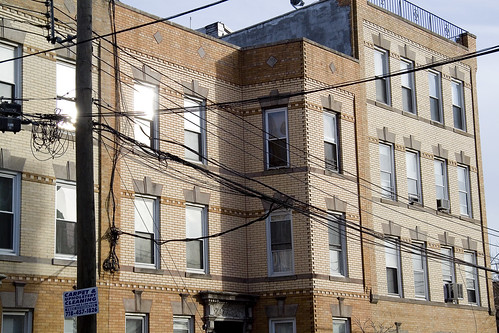
the king in yellow, brick

Matthews Model Flats, Astoria – photo by Mitch Waxman
As mentioned in the past, Newtown Pentacle HQ is embedded within one of the few corner to corner blocks of Matthews Model Flats remaining in Astoria, Queens. This is also one of the postings where I’m thinking out loud, so if your humble narrator is in error, let me know.
Yellow bricks, which once distinguished much of western Queens, compose the street faces of these buildings. This particular stretch of Matthews flats in Astoria is just about a hundred years old (1911), as is a lot of the building stock in what I’ve been told was called “the German Section”- “back in the day”. Model tenements, as they were known, and while walking my little dog Zuzu one morning I began to ponder those bricks. Those yellow bricks.
Everywhere you go, from Ridgewood to Greenpoint, Maspeth and Astoria- you see those bricks.
from an EXCELLENT illustrated history of Brick manufacturing in the New World at brickcollecting.com
The first bricks in the English colonies in North America were probably made in Virginia as early as 1612. New England saw its first brick kiln erected at Salem, Massachusetts in 1629. The Dutch colonists in New Amsterdam imported yellow bricks from Holland, which imparted a Dutch character to the architecture of the city. The excellent quality and abundance of local clays in the colonies made it unnecessary to import bricks from across the Atlantic. Brick-making centers developed in Fort Orange (what is now Albany), New York; near Philadelphia, Pennsylvania; and Burlington and Trenton, New Jersey, as well as along the Raritan River.

Grand 30th avenue, Astoria – photo by Mitch Waxman
One of the real pleasures encountered when working on postings for this, your Newtown Pentacle, are the moments when I suddenly have to research something mundane because I realize that I actually know nothing about the subject. In this case, it’s bricks.
A couple of years ago, I pursued knowledge of industrial Honey production– How, exactly, do all those millions of gallons of honey get to the little bottles in your supermarket? What can the industrial process be, I asked. The answers are pedantic, complex, and suffice to say that China is the world’s Honey superpower and that Honey was arguably the first industrial commodity.
The story of these yellow Kriescher bricks however, has something for everyone.
also from brickcollecting.com
The Manhattan Fire Brick and Enameled Clay Retort Works (as described in New York Illustrated (New York: D.Appleton & Co., 1876) was located on East 15th Street near the East River. Henry Maurer learned the fireclay manufacturing business in his uncle’s firm, Maurer & Weber, and then established his own firm which relocated from New York and Staten Island to Maurer, New Jersey, in 1874
There were several firms in New York City that took advantage of the nearby deposits of fire clay and manufactured both clay retorts and fire bricks. In 1845 Balthazar Kreischer established a fire-brick works in Manhattan, later known as the New York Fire Brick and Clay Retort Works; Kreischer acquired a fire-clay deposit on Staten Island in 1852 and established a works there which eventually replaced the Manhattan factory (his son’s house, the Charles Kreischer House and the workers’ houses for the company, the Kreischerville Worker’s Houses are both designated New York City Landmarks). Joseph K. Brick established the Brooklyn Clay Retort and Fire Brick Works in 1854. The Maurer & Weber Company later known as the Manhattan Fire Brick and Enameled Clay Retort Works, opened in 1863.
In 1868 John Cooper established a business, later known as the Greenpoint Fire Brick and Sewer Pipe Works, at 413-421 Oakland Street, Brooklyn. While there were 350 fire brick manufacturers in the United States in 1895, the New York-New Jersey area remained one of the major fire brick manufacturing centers.
Matthews Houses – photo by Mitch Waxman
19th century businessmen were either merchant princes or robber barons, depending on your point of view. Both are accurate, but suffice to say that communities of labor would cluster around the industrialist, corollary industry would arise to support growing populations around the main mill, and even competitors would often locate in their vicinity to take advantage of locale and the skilled worker population. This is why you find financial, garment, and flower districts in Manhattan and its also why Astoria is visually distinct from the neighborhoods around it.
William Steinway was here, and his interests were larger than just pianos. Steinway was a primal force in digging the first Subway Tunnel from Queens to Manhattan (completed by Michael Degnon, of course), and was a major player in the Queens Trolley business. Wealthy, philanthropic, and well regarded by all reports- Steinway’s Piano mill pulled a population to it. Out on Staten Island, Balthazar Kreischer worked a somewhat coarser but technologically sophisticated operation that made… Bricks.
from boards.ancestry.com
…trying to find the descendants of Balthasar KREISCHER (3.13.1813-8.15.1886) of the Kreischer & Sons Brick Company of Staten Island, and interred in The Green-Wood Cemetery of Brooklyn, New York.
Descendants/Family include his 4 daughters Catherine KREISCHER-WEBER, Fredricka P. KREISCHER, Louisa Albertina KREISCHER-STEINWAY and Caroline L. KREISCHER-ELLIS and his 3 sons: Charles C. KREISCHER, Edward B. KREISCHER and George F. KREISCHER. Some Kreischers settled into Brooklyn.
Louisa Albertina KREISCHER-STEINWAY (d. 6.30.1926) married Albert STEINWAY (b. 6.10.1849- d. 5.14.1877), the youngest son of of Steinway & Sons Piano Mfgr. of Astoria, New York, and had 2 daughters: Henrietta Julia STEINWAY and Ella Frederica STEINWAY. Louisa, Albert and Frederick P. Kreischer are interred in the Steinway mausoleum in Green-Wood Cemetery of Brooklyn, NY.

Maspeth Matthews Houses – photo by Mitch Waxman
Both great men were successful and accepted, rich beyond avarice, and had children. Steinway’s son Albert married Kreischer’s daughter Louisa, connecting the two families in business and standing. Both men also had holdings and interests in the burgeoning railroad business, Kreischer an investor in the Vanderbilt’s Staten Island Railroad and Steinway a rail mogul in Queens. Many of these yellow brick homes, so typical of ancient Queens, lie along the route that trolley tracks once followed.
My supposition is that Kreischer received a family discount for moving his product around on Steinway’s rails, and use of Kreischer Brick in a new project bought some good will from the Steinways- known for their generous nature and political connections in New York, Newtown, and the upstart Long Island City with its scandalous political class.
This is theory, of course, but sounds kind of like the way things worked in 19th century New York when the “old boys” club ruled. Again- theory.
from astorialic.org
“It was reported on the street on Friday that Gleason had sold his railway interests to the Steinway syndicate for $275,000. It has been reported for a long time that the Gleason roads did not pay. The road up Borden Avenue to Calvary Cemetery [in Woodside] was not well patronized. There are not many people who go to Blissville [Sunnyside] unless it is to visit the dead. The Blissville people as a rule do not travel much and when they do they patronize the Greenpoint line in preference to Gleason’s, thus his exchequer has suffered, and again the cars to the cemetery are cold this winter, and the conductors lugubrious on account of the scarcity of pennies and passengers, and a traveler after a survey of one of the cars, is tempted to foot it in preference to riding in an open car, as they had to do on Christmas Day.”

St. Joseph’s RC Church, Grand 30th avenue, Astoria – photo by Mitch Waxman
Louisa’s brother Edward, it seems, met a tragic end.
Check out this page at thecabinet.com, which tells a detailed story of that Kreischer Mansion where Edward lost his life, which describes ghostly phenomena and the violent history experienced by those who have inhabited it since.
Also, don’t miss forgotten-ny’s page on the Steinways and Kreischer’s


