Posts Tagged ‘sunnyside’
…hits the fan

– photo by Mitch Waxman
Council Member Van Bramer sent this out to his mailing list today, regarding Hurricane Irene
As everyone knows by now, Hurricane Irene is expected to hit our area sometime Saturday into Sunday. We should all take precautions to be prepared for a storm of this magnitude. Some areas in our district are in evacuation zones and at high risk for flooding. Those areas of Hunters Point/Long Island City should familiarize themselves with the map below and know that should an evacuation be ordered, Newcomers High School (28-01 41st Ave.), Aviation High School (45-30 36th St.) and W.C. Bryant High School (48-10 31st Ave.) are your nearest evacuation centers. The City will make a decision about whether to order a mandatory evacuation of Zone A for the general public by 8:00 AM on Saturday. The evacuation centers will be open as of 5:00 PM today and the City is strongly recommending that people within these areas immediately make plans to go to alternative locations outside of Zone A starting tomorrow for the duration of the storm. The orange areas are Zone A. The yellow areas are Zone B. The green areas are Zone C.

We are also concerned about significant portions of the district including parts of Sunnyside, Woodside, Astoria and Maspeth that have experienced flooding during several recent storms. Our office has been and will continue to be in contact with the Department of Environmental Protection (DEP) and other city agencies throughout this weekend. Anyone experiencing difficulties as a result of Hurricane Irene should contact me and my office as soon as they occur. We will report problems in real time. For those outside of Zone A areas that have experienced flooding or are concerned that you may, please click on the link below on how to protect your valuables. In addition to calling our office, DEP is asking for reports of flooding to be called in to 311.
http://home2.nyc.gov/html/oem/downloads/pdf/flooding_guide.pdf
I have also been in touch today with NYCHA and the Mayor’s Office to make certain that Queensbridge, Ravenswood, and the Woodside Houses are included in any and all emergency plans including evacuation, should that be necessary. We will continue to be in regular contact with NYCHA throughout the storm.
While we continue to hope for the best, we must prepare for the worst. The city has published some useful information in securing your home during the storm. Please click on the link below for recommendations on how best to prepare for the hurricane.
www.nyc.gov/html/oem/html/ready/hurricane_guide.shtml
Given the high volume of traffic to OEM’s (Office of Emergency Management) website there have been delays and interruptions in gaining access to some of these links. For that reason, we also include the Red Cross’ Hurricane Safety Checklist below. We have also included information from OEM’s Hurricane Guide at the end of this email should that link not respond when you try it.
http://www.redcross.org/www-files/Documents/pdf/Preparedness/checklists/Hurricane.pdf
In advance of the hurricane I wanted to remind you that clogged catch basin grates can aggravate flooding. Although DEP staff – with the help of their colleagues at other agencies – are busy cleaning catch basins now, DEP has asked us to remind homeowners and residents that they welcome assistance in removing leaves, litter or other debris that may prevent water from flowing off the streets and into the catch basins. For any of you that aren’t familiar with catch basins the attached link to a page on DEP’s website has some text and visuals that will help explain why flooding occurs and how citizens can help DEP minimize flooding by removing debris where they see it blocking catch basin grates.
http://www.nyc.gov/html/dep/html/flooding/flooding_causes.shtml
I will be keeping my district office open on Saturday to field questions and concerns from constituents. Needless to say, we will close the office when the storm approaches and will reopen as soon as it is safe to do so. My district office number is (718) 383-9566. I will be in the district throughout the storm and encourage anyone with problems to email me concerns at jvanbramer@council.nyc.gov as well as using social media including Facebook (http://www.facebook.com/jimmyvanbramer) and Twitter (http://twitter.com/jimmyvanbramer) to reach me. You may also call 311. Please only call 911 if you have a very serious or life threatening emergency.
I hope this update and the attached information proves useful to you. Again, my staff and I will be working throughout the weekend and please do not hesitate to contact me should you need assistance.
Sincerely,

Jimmy Van Bramer
Council Member

– photo by Mitch Waxman
Additionally, the Council Member included the following information from the Office of Emergency Management
OEM’s Hurricane Guide
To secure your home if a tropical storm or hurricane watch is issued:
Bring inside loose, lightweight objects, such as lawn furniture, garbage cans, and toys.
Anchor objects that will be unsafe to bring inside, like gas grills or propane tanks. Turn off propane tanks.
Shutter windows securely and brace outside doors.
Place valuables in waterproof containers or plastic bags.
Help Others Prepare
- Check on friends, relatives, and neighbors, especially those with disabilities or special needs, and assist them with their preparation and evacuation.
- If you live outside an evacuation zone, offer to shelter family and friends who may need to evacuate.
If Asked to Evacuate, Do So Immediately
The City will communicate specific instructions about which areas of the city should evacuate through local media. If the City Issues an Evacuation Order for Your Area: Evacuate immediately. Use public transportation if possible.
If you are going to an evacuation center, pack lightly, and bring:
- Your Go Bag
- Sleeping bag or bedding
- Required medical supplies or equipment
- Let friends or relatives know where you are going.
What about my pets?
- Make sure your disaster plan addresses what you will do with your pet if a hurricane requires you to leave your home.
- Plan to shelter your pet at a kennel or with friends or relatives outside the evacuation area.
- Be sure you have supplies ready for your pet in the event of an evacuation, including food, a leash, a muzzle, proof of shots, and a cage or carrier.
Account for your special needs
- Consider your capabilities and make sure your preparedness plan addresses how your special needs affect your ability to evacuate and shelter.
- Determine if you will need assistance and arrange help from friends, family, or neighbors.
- Consider additional supplies and equipment that you may need to bring with you, such as medicine, icepacks, medical devices, and backup equipment. Bring food for your dietary needs.
- Include additional time and evaluate your transportation options.
IF YOU LIVE IN AN EVACUATION ZONE
Prepare A Disaster Plan
Develop a plan with your household members that outlines what to do, how to find each other, and how to communicate if a hurricane strikes New York. If you rent your home, renter’s insurance will insure the items inside your apartment. If you are a homeowner, make sure your home is properly insured — flood and wind damage are not covered in a basic homeowner’s policy.
Know Where You Will Go
The City strongly recommends evacuees stay with friends or family who live outside evacuation zone boundaries. For those who have no other shelter, the City will open hurricane shelters throughout the five boroughs.
To ensure efficient use of resources, the City will ask all evacuees to report to an evacuation center. Once at the evacuation center, evacuees will either be assigned to a hurricane shelter in the same facility or transported to an associated hurricane shelter by bus.
Every household member should have a small Go Bag — a collection of items you may need during an evacuation packed in an easy-to-carry container such as a backpack. A Go Bag should be easily accessible if you have to leave your home in a hurry.
Assemble an Emergency Supply Kit
You may be instructed to shelter in place (stay at home) during a hurricane. Keep enough supplies in your home to survive for at least three days.
If you do not live in an evacuation zone
All areas of the city could face hurricane-related hazards such as high winds, flooding, tornadoes, and loss of utilities. You may be instructed to shelter in place (stay at home) for several days until the hurricane passes.
If you live in a high-rise apartment building
Residents of high-rise apartment buildings may face special risks from hurricanes even if they live outside evacuation zone boundaries. If you live in a high-rise building outside an evacuation zone, be prepared to take shelter on or below the 10th floor. If you live in a high-rise building located in an evacuation zone, heed evacuation orders.

– photo by Mitch Waxman
This looks like it will be a profound event. Personally, I’m preparing for an uncomfortable few days, but that’s because I live inland and uphill in Astoria. Long Island City and Greenpoint on the other hand…
Our friends at liqcity.com have prepared an excellent posting on the Zone A situation, which can accessed here:
http://www.liqcity.com/life/long-island-city-and-hurricane-irene-a-match-made-in-well-well-see

– photo by Mitch Waxman
Newtown Creek Alliance, an organization of which I’m a member, issued this statement earlier today…
Flood Warning for Creek Neighborhoods
Mayor Michael Bloomberg announced on August 25th, 2011 that certain emergency measures will be instituted in low lying coastal districts referred to as “Zone A” (at high risk of coastal flooding) due to the expected arrival of Hurricane Irene in the New York City area late Saturday night. Much of the land surrounding Newtown Creek is designated as “Zone A” on the coastal flooding map prepared by City officials, including large tracts of Greenpoint and Long Island City. For a map of the affected areas, please click here.
Newtown Creek Alliance cautions residents of the affected areas to monitor the situation and be prepared to evacuate should authorities warrant it necessary. If an evacuation is recommended or ordered, information about evacuation centers and hurricane shelters may be found by calling 311 or at by visiting this website. Additionally, be mindful that during such an event, the flood waters could carry a significant load of pollutants and should not be ingested. Care should be taken upon any contact with skin.

– photo by Mitch Waxman
Sources within the City have discussed this storm with me in the most dire tones. If you live in an area designated for evacuation, please comply. I’ll be marching out into the brave new aftermath early Monday morning, if there’s something which you think I should point my camera at, please contact me here. Good luck, and assuming the availability of both electrical power and internet connectivity, I’ll post as the situation develops.
As this post was being prepared, Council Member Van Bramer passed along another message, ordering the mandatory evacuation of Zone A by 5 pm Saturday.

blessed are the sleepy…

– photo by Mitch Waxman
As opined in the past, illegal dumping is a bit of an art form here in Queens, and it is not uncommon to find largish domestic items binned out at the entrance to this industrial site or that rail yard. In this case, it’s a rather plush sofa which was left nearby one of the entrances to the Sunnyside Yard, which offered this fellow an opportunity to drop off for a quick nap.

– photo by Mitch Waxman
The ability to sleep in public has always been denied to me, even as a child (much to the chagrin of Mr. and Mrs. Narrator). I marvel at the Asian folks who can catch a quick kip standing up on the R train every day, am jealous of the minute naps which others can surrender to, and can’t imagine leaving myself this vulnerable on the street for even a minute.
Back in the 80’s, if you fell asleep on the subway, someone would steal your shoes.
Things To Do!!!

– photo by Mitch Waxman
Mr. Kevin Walsh, supreme and unyielding webmaster of the intrepid Forgotten-NY.com will be teaming up with Richard Melnick of the Greater Astoria Historical Society for a walking tour of Skillman Avenue, a street which begins in Long Island City at 49th avenue and ends in Woodside at Roosevelt Avenue. Your humble narrator will be along for the trip, and has been busy producing the snazzy collateral booklet for the trip, and folks- this one is a visual feast.
Photography enthusiasts will find themselves especially pleased, as will the general antiquarian community, as we move through a fast moving and epic landscape crowded with the sky flung monumental relics of an industrial revolution.
Trace the history of Queens from a civil war era rail road station, stagger through the mighty Degnon Terminal, marvel at the titan Sunnyside Yards, and experience the pastoral glories of entering the Sunnyside- all in under 3 miles on Saturday, April 16th at 11:30AM.

– photo by Mitch Waxman
The price of this tour, and one just might think of it as tuition, for time spent with Mr. Walsh and Mr. Melnick often leaves one with the sense of having attended a scholarly dissertation- will be $25. This relative pittance, however, includes the price of an informative and handsome BW booklet written by Mr. Walsh and illustrated with photography whose odd style would be familiar to regular readers of this- your Newtown Pentacle.
The intended route is detailed here, or visit Forgotten-NY’s tour page here.
As mentioned, Mr. Melnick of the Greater Astoria Historical Society will be assisting Mr. Walsh, and has vouchsafed a discount of some 20% for the existing members of his esteemed group, bringing the price to a mere $20.
Wisdom of crowds

– photo by Mitch Waxman
UPDATE- one of the sharp eyed Lords of the Pentacle has recognized the mysterious column I mentioned in yesterday’s posting (An Odd Impulse) as being part of the Queensboro Bridge- the Great Machine itself. Following text is from the comments of TJ Connick, to whom I am now quite indebted:
Looks quite like the light stanchion that once adorned end of Queensboro Bridge wall on SE corner 2nd Av & 60th St. You can see a shot of it on NY Public Library’s Digital Gallery. Use Digital ID of 707887F in the search window. Its cousin at 59th St is still there last time I looked. Maybe someone can take a look and compare. Seem to recall a lot of time and money spent on restoration of that end about 25-30 years back. Think they took it down and lost it?
A glimpse at Google “street view” confirms. See also library’s picture: Digital ID of 730938F. It’s an old shot of 59th St stanchion. Matches yours, but yours has collar with the depending decorations upside down. Make a ransom note and send it to Dept of Transportation – could be a big score.

– image courtesy NYPL Digital Gallery
On behalf of everyone reading this posting, BRAVO TJ!
Additionally, Kevin Walsh of Forgotten-NY sends along this link to the NYTimes.com from 2001 concerning the lamp post.
an odd impulse

The Sidewalk, Barnett Avenue, Sunnyside – photo by Mitch Waxman
Apologies for recent silences are offered, for your humble narrator has found vexing distractions and urgent tasks consuming all available time. Additionally, winter has just exposed its fangs earnestly and the computer monitor lit days are blending together precipitously, causing concern that the brink of a certain madness is upon me- Cabin Fever, by name.
It feels as if one hasn’t ventured further than a block from the rented rooms in months, and the soiled sameness of all that piled snow out there just refrigerates the soul.
This long, cold, and dark time is being spent on late night historical and antiquarian researches you see, and during these sojourns into the atavist lore of ancient Newtown- certain intonations of scandal and an obscure vein of information have birthed intriguing theories about certain… things… mentioned which might still lie extant and uncommented today.
Accordingly, at my earliest opportunity, an agenda and course is set and off I will march. The purest desperation, however, drew me out onto the streets the other day.
I didn’t stray far from the Village of Astoria, merely crossing the Hunters Point, Newtown, and Flushing Turnpike, umm… I meant Northern Blvd… and never really got too far from the house as it was really way too cold out.
I’m all ‘effed up.

– photo by Mitch Waxman
A post titled “Lurking… in fear- or Astoria to Calvary, part 2” was published on August 19th of 2009, and the various features and attractions of this enigmatic stretch of road were detailed. What I didn’t talk about is that 37th Avenue is a remnant of earlier times, severed from its destination by modernity and the titan Sunnyside Yards. Hazy internet images of ancient maps hint that either “Dutch Kills Road” or “Payntar Avenue” might underlay or lie very close to the present day road’s course. If correct, this was the borderline between the Second (Blissville) and Fourth (Astoria) Wards which I was walking. This is more than an angle between neighborhoods, friends, this is an actual political boundary which doesn’t exist in modernity but nevertheless explains the presence of expanses of industrial sites near this theoretical boundary.
It’s in the angles between neighborhoods where one finds the outsider churches, the uncommented prayer circles, and other odd gatherings of initiates. It’s also where the Cats are.

– photo by Mitch Waxman
As always, the cats of Queens remind one to look for those things that you may have overlooked due to dross senses and inattention, as their race has always enjoyed certain sensitivities which are well beyond the limited range of men. Whether it be the curiously polydactyl tabbies around the Newtown Creek or the jet black blood line that dominates at Dutch Kills, one should always follow the advice of the Cats.
The one pictured in the shot above lunged at some bird, then stared at me, and turned its head back toward the direction I was walking. Dutifully, I twisted on my heels and saw…

– photo by Mitch Waxman
This gated entry point is one of the 37th Avenue portals to the NYC S.E.M./Signals Street Light Yard, a facility which stores and sorts various bits of street furniture and fittings- such as lamp posts, for instance. In warmer times, this entire fence line is encased in a thorny vine whose fruit is a foul smelling purple-red berry. The edge of an evidently large facility, it seems seldom travelled by men, but shows all signs of serving as a protected haven for the many cats observed around it.
The shattered column base stored here, however, I haven’t noticed before (although- it may well have been here- just overgrown with vegetation).

– photo by Mitch Waxman
Something about this object is familiar to me, and its identity eludes me, although my thoughts keep drifting toward mental catalogs of midtown Manhattan transportation centers. Grand Central perhaps?

– photo by Mitch Waxman
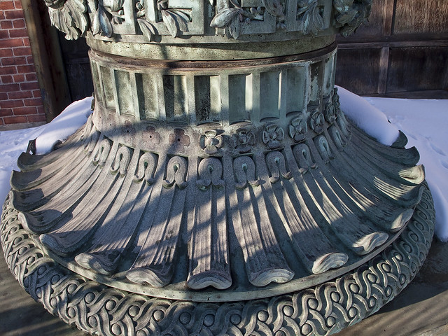
Simple observations of the object reveal it to be metallic, and designed to exhibit a cuprous patina. Were it composed of copper or white bronze, as it is designed to appear, this would be a small fortune sitting out in the snow (from a scrap metal point of view). Sculptural ornamentation and overall design suggest “City beautiful” or “Beaux Arts” era design to me, but it is difficult at best to discern such things from an object divorced of its overall and proper setting.

– photo by Mitch Waxman
Its presence at the NYC S.E.M./Signals Street Light Yard would also suggest that it’s some sort of ornamental base for a street light, but I can’t imagine where in Queens it would go. Most of what I’ve observed, in western Queens at least, is that this borough follows modernist and heroic design principals of Art Nouveau or Deco- think about the Grand Central Parkway and the Triborough approaches, the Queens Library, Flushing Meadow Park, even the Borough Hall for examples. What remains of historic Queens Plaza are the only examples of “City Beautiful” I’m aware of in the borough.

– photo by Mitch Waxman
The column base itself is of a degenerate heterogeneity, combining “egg and dart” ornaments with ionic volutes and acanthus or papyrus leaf motif. Its multiple parts and central hollows further suggest that it is meant to act as the base of some electrical lighting apparatus.
– photo by Mitch Waxman
So, Lords and Ladies- Any ideas? Anyone out there recognize this object? My instinct and observations suggest it’s a product of either the late 19th or early 20th centuries, but frankly- I’m stumped.


