Posts Tagged ‘Kill Van Kull’
thunderous remoteness
File this one under “You don’t see that every day.”

– photo by Mitch Waxman
That’s the Guy V. Molinari, part of the Staten Island Ferry fleet, in a shot from 2012. The boat is the first of its class and design, and the photo above is a fairly typical rendering of what you’d normally get to see of the boat, sans the atmospherics and dusky lighting, which was pure serendipity for a humble narrator.

– photo by Mitch Waxman
The other day, while onboard a slow boat cruising along the Kill Van Kull, I was looking at the Caddell Dry Dock facility and what do I see floating there but the Guy V. Molinari up on jacks. For you longtime readers, I’ve mentioned Caddell before, but if you need a refresher course – click here for a 2012 post about the company and their floating dry dock business. Just for giggles, here’s another one from 2014 when the USS Slater was there.
from wikipedia
The MV Guy V. Molinari, MV Senator John J. Marchi, and MV Spirit of America, known as the “Molinari class”, carry a maximum of 4,427 passengers and up to 30 vehicles. Each boat is 310 feet (94 m) long by 70 feet (21 m) wide and has a draft of 13 feet 10 inches (4.22 m), tonnage of 2,794 gross tons, service speed of 16 knots (30 km/h), and engines of 9,000 horsepower (6.7 MW).

– photo by Mitch Waxman
For those of you who didn’t bother to click through, a floating dry dock is a maritime structure capable of submersing part of its superstructure, allowing vessels to inch into it. The floating dry dock then rises back up, picking up the vessel with it. This allows free floating structures to be lifted out of the water so that workers can perform maintenance tasks on the hull and other normally inaccessible areas.
Cool, huh?

– photo by Mitch Waxman
One has seen a lot of things over the years on NY Harbor: the nose of a submarine being barged under the Williamsburg Bridge, an experimental military attack boat at Hells Gate, a space shuttle dangling from a crane, the list goes on and on. I’ve never seen a Staten Island Ferry up on blocks before.
As a note, scenery like the stuff you’re looking at today will be on display the evening of May 17th when I’m on the microphone for Working Harbor Committee’s Newark Bay tour, ticketing link at bottom of post. Come with?

– photo by Mitch Waxman
As always, Kill Van Kull was putting on the maritime industrial tour even as the boat I was on headed back out towards its eventual port of call on the Hudson River side of Manhattan Island. The whole Bayonne Bridge reconstruction project seems to be winding up, and there were crews demolishing the old concrete piers which supported the original roadway.

– photo by Mitch Waxman
Looking forward to spending a bit more time on the water, a humble narrator is.
I never got to take that vacation I was moaning about all winter, probably the best I can do for the summer is to try and not be on solid land as much as I possibly can be.
Upcoming Tours and Events
May 12th RESCHEDULED for June 9th – Exploring Long Island City – with NY Adventure Club.
Long Island City is a tale of two cities; one filled with glittering water-front skyscrapers and manicured parks, and the other, a highly active ground transportation & distribution zone vital to the New York economy — which will prevail?
Tickets and more details here.
May 17th – Port Newark Boat Tour – with Working Harbor Committee.
For an exciting adventure, go behind the scenes of the bustling Port of NY & NJ on our Hidden Harbor Tour® of Port Newark! Get an insider’s view of the 3rd largest port in the nation, where container ships dock and unload their goods from around the world. See how the working harbor really works and learn about what all those ships and tugs do. See giant container terminals, oil docks, dry dock repair, and more! Tickets and more details here.
“follow” me on Twitter- @newtownpentacle
leaden coffin
It’s National Pancake Day, in these United States.

– photo by Mitch Waxman
Note: Flickr seems to be having some issues today, so if the shots in today’s post don’t appear or display “broken” image link icons, it ain’t me.
Last week, I took a new friend over to “Skelson’s office” on the Staten Island side of the Kill Van Kull. My new pal, who is a photographer that I met during the lowering of the Koscisuzcko Bridge truss during the summer, had never been to Kill Van Kull and given that she’s into shooting the same sort of maritime industrial stuff that I am…
“Skelson’s office” is a section of the Staten Island shoreline that another photographer buddy of mine named John Skelson, who has left this world, used to haunt and this was officially his “spot.”

– photo by Mitch Waxman
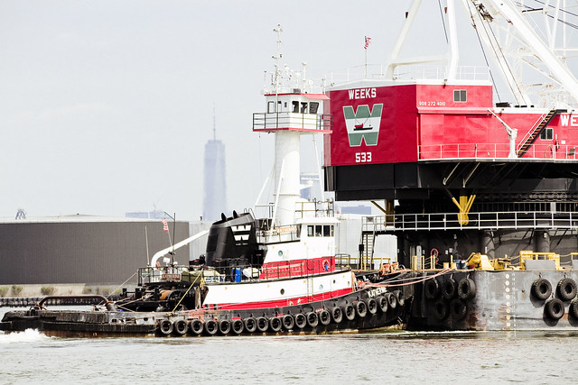
While we were at Skelson’s Office, the usual parade of tugs and barges sailed past, including the gargantua you see in today’s shots. That’s a Jersey City based Weeks Marine maritime crane, specifically the 533. Its boom is 210 feet long and it has a lifting capacity of 500 short tons. That’s 5,392 “regular people” gross tons if you’re curious. If you click over to the Weeks site via this link, you’ll see a space shuttle dangling off of it.
– photo by Mitch Waxman
There were two tugs guiding the crane along the Kill Van Kull, but the big one doing the actual towing was the Katherine, pictured above. My new pal had her mouth hanging open as this unit passed by, as you don’t see this sort of thing every day.
Well, I do, but there you go.
– photo by Mitch Waxman
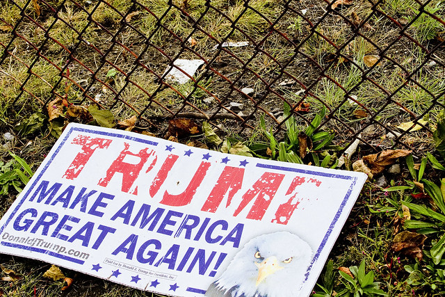
Found some garbage lying along the shoreline, and since I had to urinate, the big red letters made for a decent enough target. Great, again? America is great, now.

– photo by Mitch Waxman
The show continued along the Kill Van Kull and we spent a couple of hours hanging out and photographing the tugs and barges and container ships passing by Skelson’s Office. If you want to see this sort of thing for yourself (I mean tugs and maritime industrial goodness, not me pissing on the word “Trump”) check out the link below for the recently announced Working Harbor Committee boat tour of both Kill Van Kull and Arthur Kill on October 15th.
Upcoming Tours and events
Exploring Long Island City, from Luxury Waterfront to Abandoned Factories Walking Tour,
with NY Adventure Club – Saturday, October 7th, 1 p.m. – 3 p.m.
Long Island City is a tale of two cities; one filled with glittering water-front skyscrapers and manicured parks, and the other, a highly active ground transportation & distribution zone vital to the New York economy — which will prevail? With Newtown Creek Alliance Historian Mitch Waxman – details here.
The Hidden Harbors Of Staten Island Boat Tour,
with Working Harbor Committee – Sunday, October 15th, 2 p.m. – 4 p.m.
A very cool boat tour that visits two of the maritime industrial waterways of New York Harbor which adjoin Staten Island and Bayonne in New Jersey – The Kill Van Kull and the Arthur Kill. There will be lots of tugboats, cargo docks, and you’ll get to see multiple bridges from the water – including the brand new Goethals Bridge. I’ll be on the mike, narrating with WHC board member Gordon Cooper – details here.
“follow” me on Twitter- @newtownpentacle
raiding contingent
It’s National Sponge Cake Day, followed by the Night of the Living Dead, in these United States.

– photo by Mitch Waxman
A bit of a personal milestone is reached today, as I’ve now been amongst you all for some six hundred months. The last eighteen thousand two hundred and sixty three days have been a mixed bag, overall. Lots of boredom and pedantry, which has been punctuated by pulse pounding terror. Every now and then, one or two of the four hundred and thirty eight thousand, three hundred odd hours which I’ve experienced on this mortal coil hasn’t totally sucked. I’ve met good people, bad people, and have generally gone out of way to try and not hurt anyone who didn’t deserve it.
For all of those times when I’ve been a total asshole to someone during the roughly twenty six point three million minutes I’ve been on this planet, apologies are offered.

– photo by Mitch Waxman
There’s lessons I’ve learned, and mistakes I’ve made which I strive not to repeat. When I was born, Lyndon Baines Johnson was President of the United States (I’ve got a certificate from the White House some where congratulating my parents on my arrival) and the Woodstock festival had just wrapped up. I clearly remember a moon landing, and the Watergate investigations being broadcast live on all three television networks.
I was a weird and lonely kid, and some things never change – even after nearly one point six billion seconds.

– photo by Mitch Waxman
One is lost and deep in a “reminisce” today. Trying to remember their faces and to forget all the slings and arrows. Trying to appreciate what I’ve got, and lost, and the pageantry I’ve experienced. Overall I’ve been fairly lucky, as people of high quality who are “above my pay grade” are in my life. Also, I’m thinking about dead friends, and family.
Tonight is the Night of the Living Dead, so perhaps I’ll be seeing some of them as they try to batter in my door to feast.
Upcoming Tours and events
DUPBO Newtown Creek Walking Tour, with NYCH20 – Thursday August 24th, 7 p.m. – 9 p.m.
Explore Greenpoint and Hunters Point, with NCA Historian Mitch Waxman – details here.
America’s Workshop Newtown Creek Walking Tour, with Atlas Obscura – Saturday August 26th, 11 a.m. – 2 p.m.
Explore the Dutch Kills tributary of Newtown Creek in Long Island City, with NCA Historian Mitch Waxman – details here.
“follow” me on Twitter- @newtownpentacle
unknown caller
It’s National Escargot Day, in these United States.

– photo by Mitch Waxman
A humble narrator is fairly crispy around the edges, and in a state best described as “too little butter scraped over too much bread.” The ridiculous schedule I’ve been keeping throughout the months of April and May is beginning to wear me down a bit, and I’ve got literally thousands of photos to process and deliver to various entities. Busy is good, admittedly, but “man alive” do I need a day or two off.
Pictured above is one of the Cormorant breeding/habitat stands which are observable beneath the Bayonne Bridge, at the intersection of the Kill Van Kull and Newark Bay

– photo by Mitch Waxman
Ultimately, it’s the dog who suffers. Poor Zuzu the dog didn’t get out for her slow motion walk last night until after midnight. She’s a bit pissed off at me, my dog. Saying that, she was quite engaged with the late night sniffing, probably because every other dog in the neighborhood had already taken care of business and every tree pit was redolent with their scents and “pee mail.”
Pictured above, the spring blossoms of a tree you might observe on the corner of 45th street and 34th avenue in Astoria, Queens.

– photo by Mitch Waxman
It’s entirely likely that, as we descend into the madness of a holiday weekend, you’re going to be greeted with single image posts tomorrow, Friday, and Monday, so apologies are offered. My services have been engaged by one of the local newspapers to photograph the Maspeth Memorial Day parade on Sunday, incidentally, so if you’re there and you see some weird looking old guy with a camera and a Newtown Creek Alliance hat, say hi.
Pictured above, a double entendre laden bit of signage from Third Avenue in Manhattan. If you don’t know the street slang meaning of “Toss my salad” I’d suggest you google it, as this is a family blog.
Upcoming Tours and events
Newtown Creek Alliance and Riverkeeper Visioning, June 3rd, 1-4 p.m..
Imagine the future of Newtown Creek with Riverkeeper and NCA at the Kingsland Wildfowers Green Roof (520 Kingsland Avenue in Greenpoint) – details here.
Newtown Creek Alliance History lecture with NCA historian Mitch Waxman, June 3rd, 5:00- 7:30p.m.
An free hour long lecture and slideshow about Newtown Creek’s incredible history at the gorgeous Kingsland Wildfowers Green Roof (520 Kingsland Avenue in Greenpoint) followed by a walk around the roof and a Q&A – details here.
“follow” me on Twitter- @newtownpentacle
even thirstier than
A few tugs, observed, in today’s post.

– photo by Mitch Waxman
Last week I was invited to attend the Waterfront Alliance’s annual conference, which takes place on a large excursion boat operated by the Hornblower corporation. Onboard, there’s a series of conferences in which bigwigs and harbor heavyweights discuss this or that issue which impacts the Harbor of New York and New Jersey. Onboard… well, let’s just say that after nearly a decade of a humble narrator hanging around with the harbor crowd that there were a LOT of familiar faces. Last year the conference boat headed north along the Brooklyn and Queens coastline, but this year I was pleasantly surprised when the trip went south and we found ourselves on the Kill Van Kull separating the north shore of… Staten Island… from the chemical coast of New Jersey.
“Cool” thought I, when Moran’s “Marie J Turecamo” tug slid past!

– photo by Mitch Waxman
The Kill Van Kull seldom disappoints, as it’s a busy maritime corridor connecting the upper harbor with Port Elizabeth Newark and the cargo docks which you’ll find back there. There’s almost always a ballet of tugs and cargo ships moving through here, and after Newtown Creek and the East River – it’s the one of the NYC waterways with which I’m most familiar and can speak intelligently about.
This is, of course, due to the tutelage I was lucky enough to receive from Capt. Doswell of the Working Harbor Committee, on the many, many Newark Bay tours he led back here for WHC. I’ve studied the place on my own, of course, but when you’ve got somebody like Doswell sharing his “smarts” with you – you shut up and listen.
I believe WHC is going to be conducting a Newark Bay tour this summer, but obviously our late Captain Doswell will be there in spirit only.

– photo by Mitch Waxman
The Waterfront Alliance boat didn’t go as far back as WHC does – we didn’t get a close look at Global Marine Terminal for instance – but it was a real treat to get to shoot some tugs. I was onboard the WA boat to shoot the actual conferences, and some Oyster thing in the morning as well, but after accomplishing my “shot list” one headed topside and checked a few things off of my personal shot list.
“Franklin Reinauer” on Kill Van Kull, check.
Upcoming Events and Tours
Saturday, May 21st at 3:30 p.m. –
A Return to The Poison Cauldron of the Newtown Creek,
with Atlas Obscura, in Greenpoint, Brooklyn. Click here for more details.
Thursday, May 26th at 6 p.m. –
Brooklyn Waterfront: Past & Present Boat Tour,
with Working Harbor Committee. Click here for more details.
“follow” me on Twitter- @newtownpentacle


