Archive for August 2016
proferred food
Boredom, self hatred, and megalomaniacal fantasy – in today’s post.

– photo by Mitch Waxman
Possessed of a somewhat solitary and depressive personality type, a humble narrator is often forced to lurch forth onto the streets in search of diversion. These excursions are necessary, lest a psychological tumult be allowed to form behind the eyes and between the ears. Proprioception for one such as myself views the world thusly, with everything below the vault of the skull considered as somehow external – arms, legs, gut, and all the rest are merely there. “I” am found a few inches back from and equidistant to the ocular, nasal, mandibular, and auditory apparatus.
I’m all ‘effed up.

– photo by Mitch Waxman
One of my regular walks involves heading over to the Hells Gate section of the East River in Astoria from Newtown Pentacle HQ, which is found on the south eastern side of the neighborhood nearby its borders with LIC, Sunnyside, and Woodside. It’s a short walk, by my standards, which – there and back again – usually consumes about two hours of my time and provides some much needed physical exercise.
Saying that, I don’t always process this particular perambulatory route as being a particularly productive one from a photographic point of view.

– photo by Mitch Waxman
My colleague Kevin Walsh from Forgotten-NY often wanders through residential neighborhoods and has a fine time of it, but one such as myself shuns populated places. A humble narrator enjoys the howling winds and concrete devastations, and is drawn to lonely, damned, or deserted places. Give me the abandoned, the derelict, the despoiled, the barren, the broken, the horrible. Oh to dance merrily along the poison shoreline and shattered bulkheads of some flowing gelatinous horror, with the night gaunts…
Of course, one cannot spend all of his time at Newtown Creek.

– photo by Mitch Waxman
Truth be told, one of the things that draws me time and again to Hells Gate is that it’s the antechamber of the “House of Moses,” where mighty Triborough reigns. One of the true signs of a growing madness is working on a “theory of everything,” and I’m afraid to report that one is indeed going down that road. White laboratory coats, long black vinyl gloves, and a series of goggles are on order at a certain Internet retailer named for a South American river system, and genetic samples of the long deceased Mr. Moses are in the freezer.
My plan is to clone the master builder, and release an army of “Mosei” upon the world. They shall pave over everything and create a thousand lane highway circling the globe.

– photo by Mitch Waxman
My Moses army will pay no mind to complaints from the citizenry, instead they will crush all opposition. “You can’t make an omelet without breaking a few eggs” will be their mantra as they pour concrete for a highway whose path goes right through St. Peter’s in Rome on its way to and through Mecca on its way towards China. The Great Wall? Highway arches will be carved through it, but they will fall short of allowing buses to pass beneath them.
Part the Red Sea? The Mosei will turn the Red Sea into a parking lot dwarfing those of Riis Park or Jones Beach.. Enough of this hippie dippie environmentalist fad, let the automobile reign! The Mosei won’t lead a chosen people, instead they’ll choose which people to lead and where they’ll be led to.
Saying that, Amazon claims they’re out of stock on the mad scientist goggles, so my evil plans will just have to sit on the back burner. Someday, I tell you, someday… a real rain will come…

– photo by Mitch Waxman
Megalomaniacal fantasy notwithstanding, one still had a rather formidable workload waiting for him back at HQ, so my sojourn to the forbidden northern coast of Queens was abbreviated and my scuttle turned back towards overly familiar vicinities. For some reason, every time I cross 31st street on my way home from Hells Gate, it feels like I’m passing through the gates of Mordor.
It’s probably the perennial shadows, or the smell of sulfur.

– photo by Mitch Waxman
On Astoria Blvd., just before Steinway Street, this amusing signage was encountered on the door of a laundromat. One of the fun parts of living in a neighborhood renowned for its enormous immigrant population and legendary “diversity” is signage written by people who have less than a passing familiarity with English language grammar. Most of the neighbors just spell things the way that they sound to them, as is evinced above.
I like to believe that only “cos players” can piss therein.
Upcoming Events and Tours
Sunday, August 14th, 11:00 p.m. – 1:00 p.m. –
Calvary Cemetery Walking Tour,
with Atlas Obscura. Click here for more details.
Sunday, August 21, 11:00 a.m. – 1:00 p.m. –
Poison Cauldron Walking Tour,
with Atlas Obscura. Click here for more details.
Wednesday, August 24, 6:00 p.m. – 8:00 p.m. –
Port Newark Boat Tour,
with Working Harbor Committee. Click here for more details.
“follow” me on Twitter- @newtownpentacle
angled planes
Not rodents, the groundling burrowers are instead mammalian and obligate nasal breathers.

– photo by Mitch Waxman
The groundling burrowers have a nearly 360 degree field of vision, with their only blind spot directly in front of them at the tip of their nose. They are crepuscular (meaning they’re most active around dawn and again at dusk), and are digigrades (meaning that they walk around on their toes – five on the front feet and four on their stern). The sound of their screams are blood chilling, they have two sets of those chisel like front teeth, and just about every predator you can think of is after them. When one of their number spots danger, the groundlings are known to thump their powerful hind legs on the ground to alert the others.
The burrowers watch the skies. Death circles above.

– photo by Mitch Waxman
The groundlings burrow into the loam. Their tunnel entrances are well hidden, from above. The tunnels themselves are called burrows. If and when a complex of these subterranean tunnels – or burrows – is found, it’s referred to as a “warren.” More than half of the population of their entire race is found in North America. The males are called “bucks” and the females “does.” Should you find a place where a warren exists, you have likely found what’s known as either a nest, or a “herd,” but what is referred to most commonly as a “colony.”
The burrowers watch the horizons, for death can come at them from all sides.

– photo by Mitch Waxman
They don’t burrow deeply, the groundlings. If at all possible, they’ll move into deep burrows dug by other animals, true rodents such as groundhogs or rats. In an ideal world, perfection would be a series of already excavated voids in the earth, which these lagomorphs could theoretically connect via individual burrows and create a multi acre warren. This would form a hidden groundling metropolis of prodigious size.
Safety is found below, where death means solace.

– photo by Mitch Waxman
First Calvary Cemetery in LIC’s Blissville section, in NYC’s borough of Queens. Founded by Archbishop Dagger John Hughes in 1848 as the primary burial ground for the Roman Catholic Church of NYC. The final mailing address for millions of humans, it is observably infested with obligate nasal breathers – these groundling burrowers. Were it only possible to witness a cross section of the mound Calvary is built into, called Laurel Hill, and the warren it contains…
Who can guess, all there is, that might be buried down there?
Upcoming Events and Tours
Sunday, August 14th, 11:00 p.m. – 1:00 p.m. –
Calvary Cemetery Walking Tour,
with Atlas Obscura. Click here for more details.
Sunday, August 21, 11:00 a.m. – 1:00 p.m. –
Poison Cauldron Walking Tour,
with Atlas Obscura. Click here for more details.
Wednesday, August 24, 6:00 p.m. – 8:00 p.m. –
Port Newark Boat Tour,
with Working Harbor Committee. Click here for more details.
“follow” me on Twitter- @newtownpentacle
accomplished whatever
whatever, dude.

– photo by Mitch Waxman
As you might discern from the shot above, Our Lady of the Pentacle has a lovely set of tomatoes. She’s been busy growing stuff all summer, here at HQ in Astoria. Today’s post is a rather light one, and it’s being published late to boot, which long time readers of this – your Newtown Pentacle – will tell you is indicative of an enormous amount of new photos and posts being in production at the moment.

– photo by Mitch Waxman
Happily did I observe a flurry of published articles over the last week, proclaiming the Bronx as the new frontier for the Real Estate Industrial Complex. Hopefully, the ruination of Brooklyn and Queens will ebb a bit, as the REBNY shit flies find themselves attracted to those greener pastures and lower property evaluations that are found to the north.
Robert Moses did his level best to annihilate the Bronx decades ago, just as he did to Queens back in the 1930’s and 40’s. Perhaps the REBNY people can finish the job, and finish twisting City Hall’s knife into the “final frontier” by eliminating actual affordable housing in the name of building “affordable housing.” Carrion eaters follow the fecund scent of decaying meat after all, and despite their best efforts they haven’t managed to totally annihilate Brooklyn or Queens yet – they’ve just driven property prices so high that no one can afford to build anything here anymore. Bronx people, if you need to talk, ring us up.
The shit flies will be promising you new schools, community spaces, and waterfront parks – make sure you get them first, before they start to build the condos.

– photo by Mitch Waxman
How green does your garden grow? Whatever, dude, whatever.
Upcoming Events and Tours
Sunday, August 14th, 11:00 p.m. – 1:00 p.m. –
Calvary Cemetery Walking Tour,
with Atlas Obscura. Click here for more details.
Sunday, August 21, 11:00 a.m. – 1:00 p.m. –
Poison Cauldron Walking Tour,
with Atlas Obscura. Click here for more details.
“follow” me on Twitter- @newtownpentacle
unequal heating
Creek Week concludes, in today’s post.
– photo by Mitch Waxman
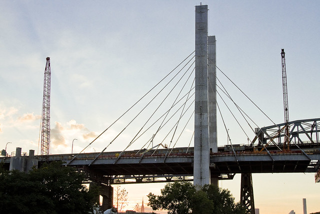
That’s the Kosciuszcko Bridge replacement project pictured above, with the 1939 Robert Moses model bridge providing a backdrop to the under construction cable stay model. That’s the Brooklyn side, for the curious. This is a $1.2 billion replacement effort, “fast tracked” by Governor Cuomo, which is intended to replace what’s considered to be the most dangerous bridge in New York State – which happens to carry hundreds of thousands of vehicle trips a day as the Brooklyn Queens Expressway runs across its 2.1 mile long structure (along with its approaches).
– photo by Mitch Waxman
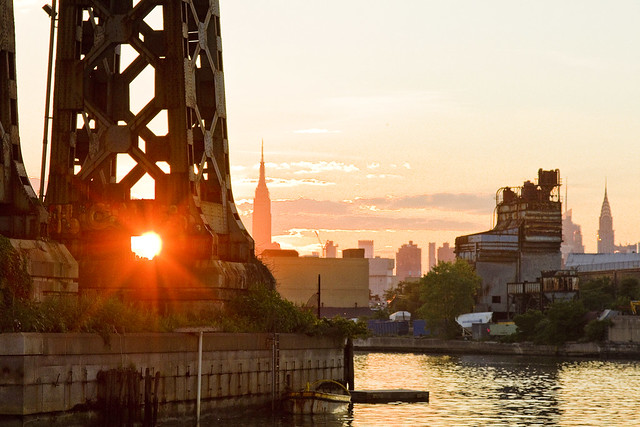
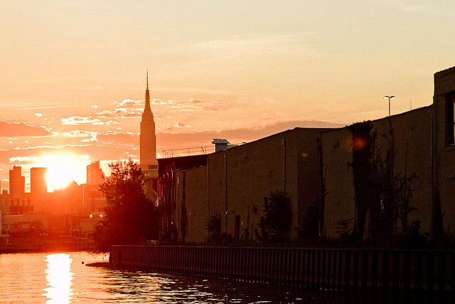
These shots were captured while onboard a NY Water Taxi hired for the evening by the Open House NY organization, and my colleague T. Willis Elkins and I were onboard to represent Newtown Creek Alliance and narrate to two sold out crowds. The second trip was heading back out from the Newtown Creek towards the East River just as sunset was occurring, and as always – Newtown Creek was and is a visual spectacular.
– photo by Mitch Waxman
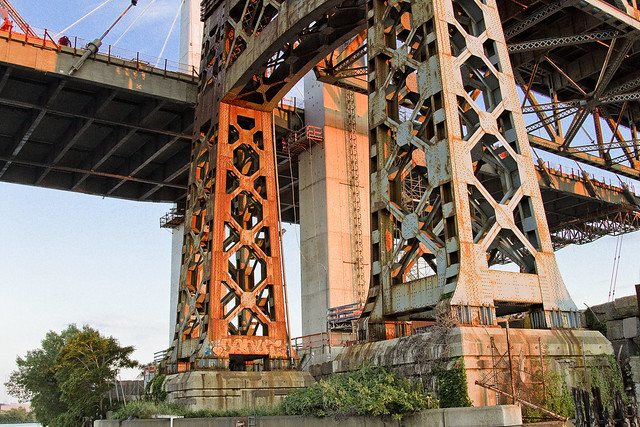
One has been trying to capture as many angles and shots as possible of the old Kosciuszcko Bridge for a couple of years now, simply because within the next 24-36 months it will have been eradicated from common memory.
This whole “Newtown Creek Historian” business isn’t just about revealing the past, it’s about leaving behind a visual record for those who haven’t been born yet about what the place looked like during its superfund and early 21st century transformational period.
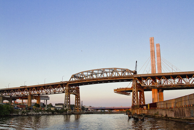
– photo by Mitch Waxman
I’ve mentioned it before, but the plan which the State DOT has put forward is that once the eastern side of the new bridge is complete, they are going to reroute the BQE onto it. Then, they’re going to demolish the 1939 model, and in its footprint, build the western section of the new cable stay bridge. The great news about that is that there is going to be a pedestrian and bicycle path on the western side of the bridge.
One looks forward to walking the camera across, and getting aerial shots from up there.
– photo by Mitch Waxman
The burning thermonuclear eye of God itself was setting in the west as our NY Water Taxi navigated back towards the East River. That’s Blissville in Queens on the right hand side of the shot above, and the former location of not just Charles Pratt’s “Queens County Oil Works” but just about the very spot where the first large scale oil refinery in the United States – Abraham Gesner’s “North American Kerosene Gas Light Company” was founded.
– photo by Mitch Waxman
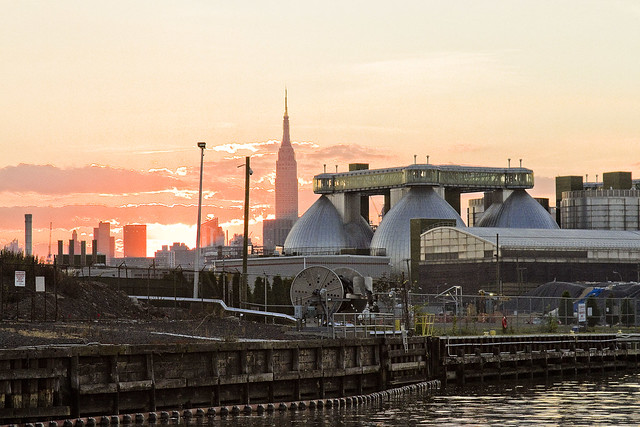
On the Brooklyn or Greenpoint side of Newtown Creek, the former home of the Standard Oil Company of New York and birthplace of what would be one day known as Mobil Oil is closest to the camera, which are now the ExxonMobil Greenpoint Remediation Project properties at 400 Kingsland Avenue.
Sitting on part of the former oil company properties in Greenpoint is the NYC DEP’s Newtown Creek Wastewater Treatment Plant, largest and newest of NYC’s 14 sewer plants.
– photo by Mitch Waxman
DUGABO – or Down Under the Greenpoint Avenue Bridge Onramp – is the heart of petroleum country on Newtown Creek. Greenpoint Avenue heads west into Brooklyn, terminating at the East River at Transmitter Park, whereas it continues into Queens and once having crossed Queens Blvd. – it transmogrifies into Roosevelt Avenue and continues all the way out into Flushing.
– photo by Mitch Waxman
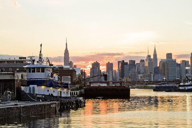
From a maritime industrial point of view, the DUGABO area surrounding the Greenpoint Avenue Bridge is probably one of the busiest sections of Newtown Creek in the 21st century. SimsMetal and Allocco Recycling host regular tug and barge traffic, as does Metro fuel.
In the distance is the Pualski Bridge and the towers of the Shining City of Manhattan.
Upcoming Events and Tours
Saturday, August 6th, 2:00 p.m. – 4:00 p.m. –
Insalubrious Valley Walking Tour,
with NY Adventure Club. Click here for more details.
Sunday, August 14th, 11:00 p.m. – 1:00 p.m. –
Calvary Cemetery Walking Tour,
with Atlas Obscura. Click here for more details.
Sunday, August 21, 11:00 a.m. – 1:00 p.m. –
Poison Cauldron Walking Tour,
with Atlas Obscura. Click here for more details.
“follow” me on Twitter- @newtownpentacle
tradition emphasizes
Creek week continues, in today’s post.

– photo by Mitch Waxman
As promised in yesterday’s post, a different perspective on the Creek is offered today. For the last few days, we’ve been on the DEP property in Greenpoint, and a birds eye perpective on DUGABO – Down Under the Greenpoint Avenue Bridge Onramp – was offered. In today’s post, the POV is from onboard a NY Water Taxi, and it’s the English Kills Tributary of the larger Newtown Creek.

– photo by Mitch Waxman
That’s the Metropolitan Avenue Bridge, as seen from the turning basin adjoining it, looking east towards Bushwick and East Williamsburg. I call this spot DUMABO – Down Under the Metropolitan Avenue Bridge Onramp. In colonial times, this was traditionally the demarcation point between fresh and brackish water on the Creek, but back then English Kills was fed by dozens of upland streams and springs. The water bubbling up out of the earth up on the hills of Ridgewood and Bushwick are part of what drew the Germans out here, and a lot of them – like the Ulmers – were involved in the beer business.
The beer guys, who do the holy work of delivering sacrament to bars and bodegas, are still in the area but there’s mainly micro brew hipster stuff going on these days and it’s fed by the DEP’s croton water system rather than ground water. The big guys like Budweiser – pictured above – ship their product in from elsewhere. There’s a pretty big beer distributor nearby on Grand Street, whose warehouse backs up on English Kills, and that Bud Light truck is likely heading there.

– photo by Mitch Waxman
Also on Brooklyn’s Grand Street is the former Charles J. King recycling company, which seems to have recently changed ownership. Luckily, the new owners continue to exploit their maritime bulkheads to ship their product out of the area, rather than truck it out. The sections of Brooklyn and Queens surrounding the eastern sector of the Newtown Creek have some of the highest concentrations of heavy truck traffic in the entire City of New York.

– photo by Mitch Waxman
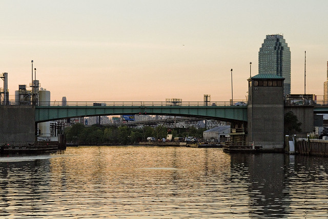
That’s the NYC DOT’s Grand Street swing bridge in the shot above, a 1909 relic of the days when Tammany Hall came to Newtown Creek shortly after the consolidation of the City of Greater New York in 1898. It’s the titular ornamentation signifying the positioning of the currently undefended legal border of Brooklyn and Queens. On the Queens side of the bridge, Grand Street becomes Grand Avenue, which travels through Maspeth and several other communities. Despite a few interruptions in its path introduced by Robert Moses, Grand Avenue eventually enters Astoria and becomes 30th avenue which heads all the way down to the East River near Halletts Cove.
Of course – on the Brooklyn side – Grand Street more or less connects to the East River in Williamsburg.

– photo by Mitch Waxman
The Brooklyn side concrete company pictured above, called Empire Transit Mix, is sited on what was once called Furman Island. There used to be two islands found in the neighborhood of Maspeth Avenue, with the smaller one known as Mussel Island. Mussel was dredged away in the WW1 era, and its spoils were used to connect Furman Island to Brooklyn. This netted Brooklyn a bit of additional land mass and supposedly increased its legislative delegations by one seat.
Furman Island is the former home of Peter Cooper’s Glue Factory, Martin Kalbfleisch’s Acid and Chemical works, and Conrad Wissel’s Night Soil and Offal dock.

– photo by Mitch Waxman
The area where the Newtown Creek widens out is referred to as “the Turning Basin” and it’s where you’ll find the National Grid company’s LNG facility, which sits on a former Manufactured Gas Plant which was operated by the Brooklyn Union Gas Company. There’s a lake of coal tar under the National Grid property, and a wall of the stuff clinging to their property in the water.
As a note, I have made multiple attempts to formally visit the National Grid site, using institutional means. Polity and smarmy conviviality have been met with a brick wall of denial of entry. Every attempt to learn what goes on there has been met with obfuscation and a cry of “Homeland Security.” It’s a “no cameras” zone, National Grid says. It’s a “Marsec 1” zone, National Grid says.
It’s visible from above, via the Kosciuszcko Bridge, and from the water, and from the street sides – say I. I’ve got long zoom lenses, as well. I’ve also got access to documentation on the place via the environmental review process, State DEC oversight, and the Superfund investigations.
One wonders what they’re hiding back in there. I’ll find out over the course of time.

– photo by Mitch Waxman
Speaking of the Kosciuszcko Bridge, at the western end of the turning basin, you’ll find the 1939 span and the replacement span which the State DOT is currently working on.
These shots were captured just last week while onboard a pair of sold out Open House NY tours of the Newtown Creek which I conducted with my colleague T. Willis Elkins from Newtown Creek Alliance. My practice on these tours is to narrate the excursion – discussing the past – in from the East River to the Metropolitan Avenue Bridge, then hand the microphone over to Willis – who discusses the future.
While he’s talking, one grabs the camera and gets busy.
Upcoming Events and Tours
Sunday, August 14th, 11:00 p.m. – 1:00 p.m. –
Calvary Cemetery Walking Tour,
with Atlas Obscura. Click here for more details.
Sunday, August 21, 11:00 a.m. – 1:00 p.m. –
Poison Cauldron Walking Tour,
with Atlas Obscura. Click here for more details.
“follow” me on Twitter- @newtownpentacle


