Archive for the ‘DUMABO’ Category
thumping rattle
Thursday
– photo by Mitch Waxman
October 20th and a humble narrator had just received the most critical bit of equipment needed to enable his “escape from New York.” A car.
All of these years in Queens, I’ve been a dedicated pedestrian and married to mass transit. I’ve always opined that having a car in Astoria is more of a curse than a boon. It was actually cheaper for me to use ride shares or cabs when I needed a ride than it was to own one.
I’m moving to America, and quite literally to “Mr. Roger’s Neighborhood,” where you cannot exist on the continent without a vehicle so I had to drop the hammer. Placed the order in July, and got a fresh from the factory new car in late October.
– photo by Mitch Waxman
Since becoming hyper mobile and independent of the geographic restrictions which are governed by how far my feet can scuttle, as well as the physical constraints of how long I can carry my photo kit, one has been ranging all over the city. Saying that, what is being missed out on now are the little things that you can’t see when driving along as you’re moving too fast.
After getting my driver’s license reinstated earlier this year, I rented a few different vehicles from Avis and Hertz, looking for a good fit for Our Lady of the Pentacle and myself. The Toyota RAV4 Hybrids rose to the top of my list, and we ordered one from one of the new car dealerships on Northern Boulevard. My accountant opined that even if I bought the thing in Alaska, NYS would still bill me for sales tax since my legal address would still here at the time of purchase, so I bit the bullet. Hopefully, this will be my last really large contribution to the black hole that Albany throws our earnings into to finance its dysfunction.
One of the bits of advice I offer is “if you’re thinking about buying a car, rent the model for a week first, and see if you like it.”
– photo by Mitch Waxman
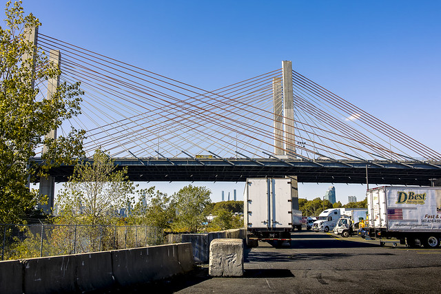
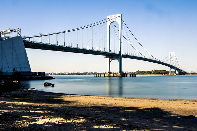
October 21st saw me taking advantage of this new mobility to get a few shots from an area that has always been a little too far off the grid for me to walk around, the coast lines of College Point and Whitestone.
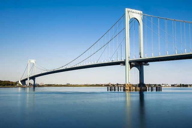
That’s the Bronx Whitestone Bridge pictured above and below.

– photo by Mitch Waxman
Funnily enough, I’ve got more shots of this bridge from the Bronx side than I do the Queens one, due to there being a ferry stop on the Soundview NYC Ferry line in the former location.
I tooled around the area, exploiting several points of view which I had previously scouted out on Google maps. The Google Maps app is a great tool as far as finding potential points of view in areas which are either tangentially known or are complete mysteries. I never would have thought to visit the “Whitestone Bridge Observatory” otherwise, or even suspected such a roundabout street end existed.
– photo by Mitch Waxman
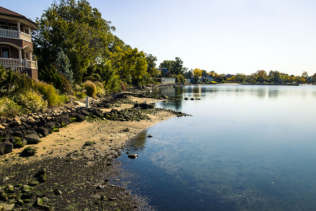
Whitestone seems to be a super wealthy community, with expansive homes that border on “mansion” nestled right up against the water. It looks more like a suburb than it does NYC. You don’t see piles of cast off garbage or debased humans lying in the street, for instance.
I had several photo set ups planned for the day, and since I was in a car, didn’t mind carrying all of the heavy kit which would normally create a limit on how far and wide I could range.
– photo by Mitch Waxman
There aren’t too many Sandy beaches on the East River. I think it’s about 6 or 7, that I know about at least. That’s one of them, above, at Francis Lewis Park. Nice spot.
One kept on heading eastwards, right up and sometimes over the City/Nassau County line.
More on that tomorrow at your – now – hard driving Newtown Pentacle.
“follow” me on Twitter- @newtownpentacle
Buy a book!
“In the Shadows at Newtown Creek,” an 88 page softcover 8.5×11 magazine format photo book by Mitch Waxman, is now on sale at blurb.com for $30.
subdued sort
Tuesday

– photo by Mitch Waxman
After returning from Pittsburgh, a humble narrator set about developing photos and chilling out for a couple of days before resuming the normal round. Some Newtown Creek Alliance business found me in Brooklyn’s East Williamsburgh section, alongside the Metropolitan Avenue Bridge, on September the 8th.
We were checking out a venue for our annual fundraiser – the Tidal Toast – and needed to do a walkthrough. NCA is awarding a humble narrator with the “Reveal” award in this – my last year on Newtown Creek – on October 20th. If you’d like to attend, and support a great organization which has been central to the last 15 years of my life, click here for more information.

– photo by Mitch Waxman
After a week of traveling in Pittsburgh, and all of those heavy breakfasts, the idea of a walk back to Astoria afterwards sounded fantastic to me. The weather was great, and my camera batteries full.
This is the view from the venue that the Tidal Toast will be held at, which is the Brooklyn studios of a hand painted advertising sign and billboard company called Colossal Media.

– photo by Mitch Waxman
My plan for the afternoon was simple. I walked down Grand Street, towards the Grand Street Bridge crossing on Newtown Creek’s tributary English Kills, where Grand Street transmogrifies into Grand Avenue when it enters the Maspeth section of Queens.
Along the way, there’s a lot of sights. Pictured above is a metals recycling operation.

– photo by Mitch Waxman
That’s the Grand Street Bridge, which is going to be replaced fairly soon. Something I’m going to miss out on.
Since I was in the neighborhood, one pointed his toes first at the Maspeth Avenue Plank Road, and then at the Maspeth Creek tributary.

– photo by Mitch Waxman
There were a passel of Canadian Dicks Geese in the poison waters of Maspeth Creek, swimming around and dunking their heads into the slimy liquidity, to eat up whatever debased forms of life they subsist off of.
In recent years, Newtown Creek has become infested with noisome and quite aggressive Canada Geese.

– photo by Mitch Waxman
A cast away automobile was visible on the shoreline when I was passing by. Visibility is related to where you are in the tidal cycle for this sort of thing.
The geese didn’t care, nothing matters to them either.
“follow” me on Twitter- @newtownpentacle
Buy a book!
“In the Shadows at Newtown Creek,” an 88 page softcover 8.5×11 magazine format photo book by Mitch Waxman, is now on sale at blurb.com for $30.
northward pull
Wednesday, the dusk of the week.

– photo by Mitch Waxman
One can affirm that the Metropolitan Avenue Bridge is still there, as of last week. A small but double basculed draw bridge which spans the English Kills tributary of the fabled Newtown Creek, Metropolitan Avenue Bridge is 3.1 miles from the East River. You don’t see much in the way of maritime traffic back here, but there’s usually a tug and fuel barge found at the Bayside fuel depot’s bulkheads.
One would advise the curious that the shoreline is crumbling, and you want to be REALLY careful anywhere near the ragged edge of the land if you don’t want to end up immersed in Newtown Creek’s most polluted section. If you’re not being careful, the dice will roll and it’s either going to be X-Man or Liver Cancer for you.

– photo by Mitch Waxman
A couple of old fuel trucks are permanently stationed hereabouts, which endlessly fascinate me with their late 20th century design cues and onboard signage.
The burning thermonuclear eye of god itself was dipping behind Manhattan just as I arrived at the bridge, which served as my turnaround point on this particular walk. One does not decide in advance on where the pivot takes place, but it is often considered. That’s the thing about the street grid surrounding Newtown Creek – there’s so many dead ends and cul de sacs, which aren’t a big deal when you’re in a vehicle, but if on foot you need to factor them into your route.

– photo by Mitch Waxman
It was when I pivoted that the roar of powerful engines was heard. Frankly, I thought that a massive nocturnal bit of construction might be afoot due to the noise which was clearly audible even with my headphones in and Black Sabbath playing. It was approaching the sound levels encountered nearby the helicopter landing pads you encounter on the east side of Manhattan.
More on the tumult tomorrow.
Note: I’m writing this and several of the posts you’re going to see for the next week at the beginning of the week of Monday, September 28th. My plan is to continue doing my solo photo walks around LIC and the Newtown Creek in the dead of night as long as that’s feasible. If you continue to see regular updates here, that means everything is kosher as far as health and well being. If the blog stops updating, it means that things have gone badly for a humble narrator.
“follow” me on Twitter- @newtownpentacle
Buy a book!
“In the Shadows at Newtown Creek,” an 88 page softcover 8.5×11 magazine format photo book by Mitch Waxman, is now on sale at blurb.com for $30.
correlated causeways
Eleven bridges, one creek.

– photo by Mitch Waxman
Pulaski Bridge is the first span you encounter, when you’ve left the East River and embarked on a journey down the fabulous Newtown Creek. A double bascule drawbridge, and electrically powered, the Pulaski Bridge connects 11th street in Long Island City with McGuinness Blvd. to the south in Brooklyn’s Greenpoint. Built in 1954, the Pulaski Bridge is owned and operated by the New York City Department of Transportation or “NYC DOT.” The Pulaski Bridge carries five lanes of traffic, plus a dedicated bicycle lane and a separate pedestrian pathway. It overflies the Queens Midtown Tunnel and Long Island Expressway, as well as active railroad tracks found on Borden Avenue.

– photo by Mitch Waxman
DB Cabin acts as a gatekeeper to the Dutch Kills tributary of Newtown Creek. It’s a railroad swing bridge owned by the Long Island Railroad, and connects two rail yards – the Wheelspur Yard (to the west, or left in the shot above) and the Blissville Yard – across the water. Both rail yards and the bridge itself are part of the LIRR’s Lower Montauk tracks. DB Cabin dates back to the 1890’s and is in a terrible state of repair. The swing bridge’s motors are nonfunctional, which isolates the Dutch Kills tributary from maritime traffic, and from the rest of the Newtown Creek.

– photo by Mitch Waxman
Cabin M is just to the north of DB Cabin on Dutch Kills, and the single bascule drawbridge connects the Montauk Cutoff with the Blissville Yard mentioned above. The Montauk Cutoff is an elevated track which used to provide a connection between the LIRR’s Main Line tracks at the nearby Sunnyside Yards with the Lower Montauk tracks along the north (or Queens side) shoreline of Newtown Creek. The 2020 Capital Plan just released by the Long Island Railroad’s owner – The MTA – includes funding to demolish Cabin M.

– photo by Mitch Waxman
Borden Avenue Bridge is owned by the NYC DOT, and is one of just two retractile bridges in NYC (the other being the Carroll Street Bridge over the Gowanus Canal). Built in 1908 to replace an earlier wooden drawbridge (1868) at the intersection of Borden Avenue and Dutch Kills, Borden Avenue Bridge received extensive upgrades and structural repairs in 2010 and 2011, and had its electronic components destroyed by flooding during Hurricane Sandy. Another round of repairs and upgrades began in 2019, which included asbestos abatement work.

– photo by Mitch Waxman
The Long Island Expressway is 71 miles long, and is operationally managed in three sections. The Queens Midtown Expressway is how it’s owners, the New York State Department of Transportation, refer to the section found between the Queens Midtown Tunnel and Greenpoint Avenue in Long Island City. This section is elevated, rising to 106 feet above the waters of Dutch Kills. The LIE truss pictured above handles some 87.7 thousand daily vehicle trips, or 32 million annually, to and from Manhattan,
– photo by Mitch Waxman
Hunters Point Avenue Bridge is due north west of Borden Avenue Bridge and the LIE truss. It’s a single bascule drawbridge, owned by the NYC DOT. Replacing an earlier wooden draw bridge that was opened and closed by a donkey walking on a wheel, the Hunters Point Avenue Bridge was built in 1910. Back then, it was a double bascule bridge, but a rebuild in the 1980’s simplified the mechanism to a single bascule. The masonry of the bridge is original to the 1910 design.

– photo by Mitch Waxman
The Greenpoint Avenue Bridge is found some 1.37 miles from Newtown Creek’s intersection with the East River, and roughly a half mile from the mouth of Dutch Kills. It’s a double bascule bridge, built in 1987, and owned and operated by the NYC DOT. There have been many Greenpoint Avenue Bridges, dating back to the first one built by Greenpoint’s town father Neziah Bliss back in 1850, but that one was called the “Blissville Bridge.” The Greenpoint Avenue Bridge is a traffic machine, carrying 28.3 thousand vehicle trips a day, or about ten million a year. Most of that traffic takes the form of heavy trucking.

– photo by Mitch Waxman
The brand new Kosciuszko Bridge(s) replaced a 1939 vintage truss bridge that carried the Brooklyn Queens Expressway over Newtown Creek and are found some 2.1 miles from the East River. The NYS DOT is busy putting the finishing touches on the new cable stay bridge’s construction. In addition to the… ahem… high speed traffic lanes of the BQE, there is also a pedestrian and bicycle pathway found on the new Kosciuszko Bridge which connects 43rd street in Queens’s Sunnyside section with Meeker Avenue in Brooklyn’s Greenpoint.

– photo by Mitch Waxman
The Grand Street Bridge is a swing bridge connecting Maspeth’s Grand Avenue in Queens with East Williamsburg/Bushwick’s Grand Street in Brooklyn. 3.1 miles back from the East River, in a section of Newtown Creek once called “White’s Dock,” the NYC DOT have recently announced plans to replace this 1909 beauty – which is actually the third bridge to occupy this spot. Damage from Hurricane Sandy, and the narrow roadways with height restrictions that the bridge offers, have pretty much sealed its fate. It will be missed.
This is where the main spur of Newtown Creek ends, as a note. Directly east is a truncated tributary called the East Branch, and another tributary called English Kills makes a hard turn to the south just before you encounter Grand Street Bridge.

– photo by Mitch Waxman
Metropolitan Avenue Bridge is a double bascule drawbridge that crosses the English Kills tributary of Newtown Creek, and is owned by the NYC DOT. Metropolitan Avenue was originally built as a private toll road in 1813, and the first bridge here was a part of the “Williamsburg and Jamaica Turnpike.” The current Metropolitan Avenue Bridge was built in 1931, although it has received significant alterations in 1976, 1992, 2006, and again in 2015. The 2015 alterations?
You guessed it, Hurricane Sandy strikes again.

– photo by Mitch Waxman
Montrose Avenue Rail Bridge is the final crossing found over the waters of Newtown Creek and its tributaries. Some 3.7 miles back from the East River, it’s the property of the Long Island Railroad and used for freight service on their Bushwick Branch tracks. A truss bridge, or trestle if you must, my understanding of things are that whereas the trackway and parts of the rail bridge date back to approximately 1924… there has been quite a lot of work done on the thing which I have not been able to fully document so rather than fill in blanks with assumptions – I’m just going to say that I don’t know everything… yet.
It’s an active track, it should be mentioned.
“follow” me on Twitter- @newtownpentacle
Buy a book!
“In the Shadows at Newtown Creek,” an 88 page softcover 8.5×11 magazine format photo book by Mitch Waxman, is now on sale at blurb.com for $30.
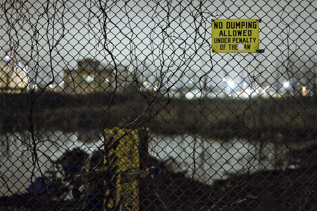
present quarters
No dumping allowed.
– photo by Mitch Waxman
Back in 1919, Brooklyn Union Gas moved from the Gowanus Canal to Newtown Creek, creating a 115 square acre Manufactured Gas Plant called the Vandervoort Street Facility, with a farm of cylindrical gas holders. BUG would eventually be purchased by Keyspan Energy, which would itself later be acquired by National Grid. This is where the so called “Maspeth Holders” were imploded in 2001, and the property is generally referred to – in modernity – as the “National Grid Site.” They don’t manufacture gas here anymore, instead they store and process “LNG” or Liquified Natural Gas, which is brought out of its cryogenic status through some arcane technological wizardry for pipeline delivery to the ovens and furnaces of Brooklyn.
At least a third of their property is relict, and seemingly abandoned. Along the chain link fences of Vandervoort Street, you’ll notice that they’ve allowed a small lake to form in the footprint of some long ago industrial structure.

– photo by Mitch Waxman
While out the other night on my “night shot” walk, mounds of dumped garbage were noticed around the edges of the small lake on the southern or Vandervoort Street side of the National Grid Site. I guess it’s their property, they can do what they want with it, but personally speaking I try not to poop on my living room carpet.
I also try not to poop where a passing photography enthusiast might notice it.

– photo by Mitch Waxman
There were a couple of these mounds, which looked to be commensurate with what you expect to be able to pack into a medium sized truck. Not sure how long this has been here, as I haven’t wandered past this particular spot in a couple of months.

– photo by Mitch Waxman
I’ll be sending this post over to the National Grid people and asking what’s going on here. If I get an answer from them which I can share, then you Lords and Ladies will certainly be the first to know it.
As a note, the preceding shots were handheld, breaking with the tripod ones for a hot minute,

– photo by Mitch Waxman
Once I turned onto Metropolitan Avenue, however, I got busy with the cable release and tripod action again.
“follow” me on Twitter- @newtownpentacle


