Archive for the ‘Dutch Kills’ Category
calloused outlook
A few shots from the Degnon Terminal, in today’s post.

– photo by Mitch Waxman
Modernity knows the complex of cyclopean factory buildings along Thomson Avenue in Long Island City as the campus of LaGuardia Community College. If – like me – you can see through time to earlier ages, you know that Thomson Avenue was named for the guy who used to own the Neptune Water Meter company over on Jackson Avenue, a recently demolished building which in the latter 20th and early 21st centuries was the home of 5ptz. You’d know that until the start of the 20th century, this area was a pestilential mosquito breeding swamp known as the waste meadows, and that it wasn’t until the Pennsylvania Railroad decided to site their Sunnyside Yard nearby that the swamp was drained and filled in.
The waste meadows were owned by the estate of a former Governor of New York State named Roscoe P. Flowers, and their acreage was bought up by the Degnon Terminal Realty company.

– photo by Mitch Waxman
Michael Degnon was a contractor who could accomplish the impossible during the age of “progress” in the newly consolidated City of Greater New York. He came to prominence installing the masonry cladding of the Williamsburg Bridge and finishing the subway tunnels which August Belmont and William Steinway had started. The rock “spoils” which were produced when mining the subway tunnels connecting Queens and Manhattan were brought here to LIC, raising the land to a high and dry condition. Degnon began to sell his land off to large industrial concerns, and constructed their factories for them. His Degnon Terminal offered a “terminal railway” which allowed for shipping connections to maritime barge and cargo ships at Newtown Creek’s Dutch Kills tributary, as well as direct connections to the Long Island Railroad and Pennsylvania Railroad trackages on the LIRR’s Lower Montauk and Main Line. Additionally, connections to the New York Connecting Railroad and the Hell Gate bridge were possible as well. Degnon is buried in First Calvary Cemetery if you’d like to leave him some flowers.
As the Queens Chamber of Commerce called it contemporaneously, Queens was the “Borough of Homes and Industry” a hundred years ago.

– photo by Mitch Waxman
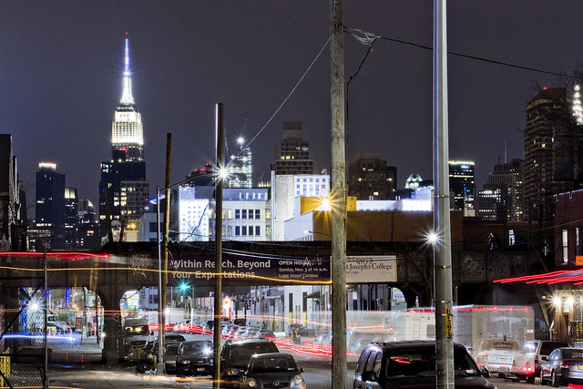
Just this last week, a meeting of the “Newtown Creek Superfund Community Advisory Group” was held at one of CUNY’s LaGuardia Community College buildings in the former Degnon Terminal, and as is my habit – the camera was deployed before and after the meeting. The shot above looks north in the direction of the Sunnyside Yard and you can just see the arch of the Hell Gate Bridge on the horizon. That yellow streak is the IRT Flushing Line – or 7 train – moving through the shot while the shutter was open for about fifteen seconds.
Upcoming Tours and Events
June 22nd – The Birthplace of Mobil Oil: A Walking Tour
– with Newtown Creek Alliance.
Join NCA historian Mitch Waxman and NCA’s project manager Willis Elkins for walk through the birthplace of Mobil Oil, past the DEP’s largest Wastewater Treatment Plant and to the Kingsland Wildflowers green roof. The tour will also visit NCA’s Living Dock on the way; showcasing restoration efforts adjacent to major industrial operations and in the wake of legacies of pollution and neglect.
The tour will end at the 22,000 square foot Kingsland Wildflowers project, with panoramic views of the Newtown Creek and Manhattan skyline at sunset.
Tickets and more details here.
June 30th – The Skillman Avenue Corridor
– with Access Queens.
Starting at the 7 train on Roosevelt Avenue, we will explore this thriving residential and busy commercial thoroughfare, discussing the issues affecting its present and future. Access Queens, 7 Train Blues, Sunnyside Chamber of Commerce, and Newtown Creek Alliance members will be your guides for this roughly two mile walk.
Skillman Avenue begins at the border of residential Sunnyside and Woodside, and ends in Long Island City at 49th avenue, following the southern border of the Sunnyside Yards for much of its path. Once known as Meadow Street, this colonial era thoroughfare transitions from the community of Sunnyside to the post industrial devastations of LIC and the Dutch Kills tributary of Newtown Creek.
Tickets and more details here.
“follow” me on Twitter- @newtownpentacle
most unplaceable
Odds and ends, needles and thread.
– photo by Mitch Waxman
On this day in 404 B.C., the Peloponnesian War ended when the Spartans crushed the Athenians with a naval blockade. Sometime later, in 1792 A.D. the French rolled out the guillotine for the first time, ending the life of a highwayman named Nicolas J. Pelletier. In 1859, ground was broken for the Suez Canal by French and English engineers. The Spanish American War officially began with a declaration by the United States Government on April 25 in 1898. In 1945, American and Soviet troops joined up at the River Elbe in Germany. In 1953, Crick and Watson publish their paper describing DNA, and in 1960 the US Navy Submarine Triton competes the first submerged circumnavigation of the earth. In 1983, Pioneer 10 travelled beyond the orbit of Pluto. In 1940, Al Pacino was born. So was Edward R. Murrow, but that was in 1908.
Today is also World Malaria Day.

– photo by Mitch Waxman
On this day in 1901, New York became the first state to require automobiles to carry license plates. During the First World War, the disastrous Gallipoli Campaign was launched in 1915. In 1945, what would become the United Nations sat down to chat, plan, and organize in San Francisco. Polaroid introduced the instant camera to customers in 1972, and the Hubble Space Telescope was deployed from the Space Shuttle Discovery in 1990.
Personally, I’m stuck in front of the computer at HQ all day today and have an abundance of tasks to accomplish.

– photo by Mitch Waxman
One will be writing tour descriptions for upcoming excursions around the fabled Newtown Creek and larger harbor, developing the shots I managed to squeak out last night before it started raining again, and generally servicing the needs of an increasingly elderly dog named Zuzu today. A busy few days are in front of me, which will be carrying the camera across the concretized realities of the great human hive, with everything culminating in a tour I’m conducting with my pal Kevin Walsh from Forgotten-NY for the Newtown Historical Society on Sunday. Link for tix is below, which are only $5.
Come with?
Upcoming Tours and Events
April 29 – Bushwick-Ridgewood borderline Walking Tour – with Newtown Historical Society.
Join Kevin Walsh and Mitch Waxman as they take us along the border of Brooklyn and Queens, Bushwick and Ridgewood, with stops at English Kills, an historic colonial Dutch home, and all kinds of fun and quirky locations. End with an optional dinner on Myrtle Avenue before heading back to the Myrtle-Wyckoff subway station. Tix are only $5 so reserve your space today!
Tickets and more details here.
“follow” me on Twitter- @newtownpentacle
rather gruesomely
Like every other bit of wind blown trash in NYC, this is where I belong.

– photo by Mitch Waxman
Despite being a shambling and sclerotic mess, nevertheless does a humble narrator scuttle on about and around the Newtown Creek in the middle of the night. Recent endeavor found one in Blissville to attend a meeting of the newly created Blissville Civic Association, which the community has formed in response to the Mayor dropping multiple homeless shelters into their midst, and afterwards one set out to a nearby tributary of that legendary cataract of urban malfeasance known as the Newtown Creek – specifically Long Island City’s Dutch Kills.
That’s the Borden Avenue Bridge in the shot above, but don’t ask me where the shot was captured from as I’d have to confess to a misdemeanor. Suffice to say that every nook and cranny is known to me. It’s all I’ve got, ultimately.

– photo by Mitch Waxman
Either the world happens to you, or you happen to the world.
That’s the Long Island Expressway above, riding on a truss bridge that carries it some one hundred and six feet over the waters of Dutch Kills. The height was determined by the demands of the War Department of the Federal Government, who had laid down the law to State of New York that the LIE would need to allow egress for maritime vessels on Dutch Kills, and specifically vessels of the Naval surface warfare type.

– photo by Mitch Waxman
One has read some of the planning documents for this section of the LIE, which is officially the Queens Midtown Expressway, and sections of said plans discussed the need to defend Newtown Creek and the larger harbor of New York against a potential maritime invasion by German naval forces in the run up to WW2. One of the guiding principles was the defense of the industrial zones, and the East River corridor specifically. The Navy’s theory was that the Kriegsmarine would enter New York Harbor via the Narrows between Brooklyn and Staten Island (there was no bridge there in the 1930’s) and that would be the most strategic and effective spot to interdict the German Navy. Accordingly, in the case of such an invasion they would have stationed Destroyer class vessels in Newtown Creek and the Gowanus (as well as other places) to act as protective bulwarks for the industrial operations.
The Navy plan also intended for the Destroyers to fire artillery southwards over Brooklyn to shell the Narrows on vast parabolas. The people in Bay Ridge would have loved that one, I tell you, had it been commonly known. Fuhgeddaboutit.
Upcoming Tours and Events
April 29 – Bushwick-Ridgewood borderline Walking Tour – with Newtown Historical Society.
Join Kevin Walsh and Mitch Waxman as they take us along the border of Brooklyn and Queens, Bushwick and Ridgewood, with stops at English Kills, an historic colonial Dutch home, and all kinds of fun and quirky locations. End with an optional dinner on Myrtle Avenue before heading back to the Myrtle-Wyckoff subway station. Tix are only $5 so reserve your space today!
Tickets and more details here.
“follow” me on Twitter- @newtownpentacle
blossoming orchards
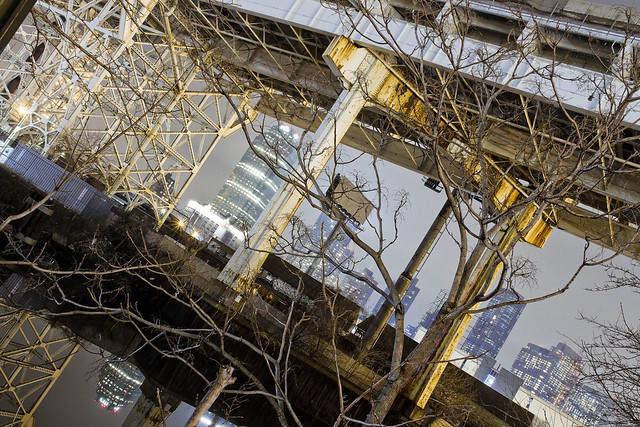
Down under the Long Island Expressway, or DULIE, in today’s post.

– photo by Mitch Waxman
So, after shlepping my tripod setup around Dutch Kills last weekend, I decided that I just wasn’t done yet. Heading east alongst the venerable avenue of Borden, a humble narrator found a few interesting spots to do a “setup” and get clicking. It was DULIE which captured my attention on this leg of the walk.
As mentioned in an earlier post, the LIE and Queens Midtown Tunnel opened for business in November of 1940. The LIE, where it crosses the sediment choked waters of Newtown Creek’s Dutch Kills tributary here in Long Island City, rises one hundred and six feet above the water. This means a lot of steel supports, and an empty corridor found beneath it.

– photo by Mitch Waxman
One is obsessed with this section of LIC, as so much has happened here. The General Electric Vehicle Company complex was just a block away, so were a couple of steel factories. A fossilized rail spur can still be found here and there, winding it way around and between the factories, but the locomotive city is long gone. It’s all about the internal combustion engine in modernity – the automobile city.
The principal proponent of the latter didn’t begin the Queens Midtown Tunnel, he just took it over towards the end of the project and made sure the LIE would be his baby. I’m speaking of Robert Moses, of course.

– photo by Mitch Waxman
The sewer grates up on the LIE connect to long vertical pipes, which just empty out onto the ground, and their flow carries all sorts of “yuck” down into LIC from the expressway high above. There’s meant to be a little concrete spillway which would carry the liquid and solute “spill” into a second grate, one which basically empties into Dutch Kills, but the build up of “crapola” around the pipe creates sickly mounds of toxic soil like the one pictured above.
Hey, I’m not judging, I love places like this.

– photo by Mitch Waxman
As a note, whenever I’m describing an encounter with the Gendarmes or some zealous security guard, I always go on about “there being no law forbidding…” and “if you can see it from the sidewalk…”.
In the case of the other night however – picture this: some weird looking bearded old man standing in pitch darkness on a Sunday night with a camera tripod under the LIE, wearing a reflective vest over a filthy black raincoat – I was ready to converse with somebody wearing a badge about what I was up to. You’d just figure that, right?
The cops though, three cruiser units worth spaced out over the evening, just drove on by me. I mean… I felt suspicious looking. The reflective vest is very good camouflage. Instead of being high visibility as promised, it’s a near invisibility prophylactic against “why are you taking pickchas of dat?”

– photo by Mitch Waxman
One was growing fatigued by this point, it was well after ten, and a humble narrator embraced an ideation about starting out for home. One last long exposure shot from DULIE was executed, and thereupon the tripod kit was folded up into its traveling configuration and a lens swap occurred.

– photo by Mitch Waxman
The lens I’ve been using for the series of night shots recently has been a Sigma 18-300 – which is by definition a “daylight lens, given that at full zoom it’s aperture is only f6.3. Tripod shots, like the ones I’ve recently been producing, make the usage of extremely narrow apertures possible – which in turn allows for a deep field of focus. Impossible for handheld usage in low light, however, this lens is. It’s singular virtue is the zoom range, ultimately. I’ve got better lenses, including a different Sigma, but this particular specimen allows me to carry just one lens.
I’ve always got a “nifty fifty” lens in my bag, however, which allows me to open up the aperture to f1.8, allowing a lot more light in. That’s the one I snapped onto the camera, which coincidentally lightened the gizmo by about a pound and a half. Lotta glass inside that Sigma, but you don’t really feel the weight of it when it’s in the bag.
“follow” me on Twitter- @newtownpentacle
long miles
Borden Avenue Bridge and environs, in today’s post.

– photo by Mitch Waxman
There have been three Borden Avenue Bridges, the first being a wooden draw bridge that opened when Borden Avenue was created in 1868. It was replaced by an iron swing bridge which was demolished in 1906, and the modern day retractile bridge was opened on the 25th of March in 1908. It cost $157, 606 to build in 1908. That would be $4,365,073 in modern money, adjusted for inflation.
A bargain, no?

– photo by Mitch Waxman
Borden Avenue Bridge is one of only two retractile bridges in NYC, the other one being the infinestimal Carroll Street Bridge over the Gowanus Canal. This specie of movable bridge is actually quite common in other cities, notably Chicago.
Chicago ain’t got a view like the one above though, I’d wager.

– photo by Mitch Waxman
To the south of Borden Avenue, one might notice the two railroad bridges spanning Dutch Kills – Cabin M and DB Cabin. The latter carries traffic for the Lower Montauk Branch of the LIRR from the Wheelspur to Blissville Yards, all of which which are mainly used for freight these days. Cabin M connects to the Montauk Cutoff, a now severed connection to the Sunnyside Yards and the LIRR Main Line tracks.
Just beyond the two rail bridges is the main body of Newtown Creek.
– photo by Mitch Waxman
Dutch Kills itself, in this area around the Borden Avenue Bridge, is stagnant and choked with wind blown garbage. A tepid current in the water creates a vertical rather than horizontal flow pattern, which factors into the accretion of sediments on the bottom. These sediment beds, which are found across the entire Newtown Creek watershed and represent a centuries long cross section of industrial and municipal pollution, are the reason that the Creek and its tributaries are a superfund site.
At low tide, mounds of this material become exposed to the air.

– photo by Mitch Waxman
For many years, there was a shanty dwelling here, occupied by some unknown entity. Hurricane Sandy ended that tenancy.

– photo by Mitch Waxman
My chosen path next carried me eastwards on Borden Avenue, away from my beloved Creek and deeper into the post industrial landscape of Long Island City. The concrete devastations were calling to me.
“follow” me on Twitter- @newtownpentacle


