Archive for the ‘East River’ Category
distant whine
The ugly half of walking over any East River Bridge – the Manhattan side.

– photo by Mitch Waxman
Looking back over my shoulder, in the direction of Queens, on the pedestrian and bicycle lane of mighty Queensboro. As stated in the past, Queensboro was ceremoniously renamed for a former Mayor a few years back, and anytime someone is observed calling this span the Ed Koch bridge it just pisses me off. Accordingly, I’ve proposed renaming the Brooklyn Bridge as the “Michael Bloomberg Bridge.” Sounds outrageous and insulting to history, Brooklyn, and the Roeblings, and indicative of a somewhat crass bit of political excess? Exactly.
You couldn’t get away with it in Brooklyn, but you can in Queens where the borough motto seems to be “Welcome to Queens, now go fuck yourself.”
A long walk from Astoria to Manhattan’s east side – specifically the 20’s along Third – via the Queensboro, was the subject of yesterday’s and indeed today’s post. Today we land in a cautionary tale called Manhattan.

– photo by Mitch Waxman
The bridge’s pedestrian lane makes landfall at 2nd avenue and 60th street. For some reason, the DOT has barriers set up at the bottom of the ramp which cause bicyclists to execute a sharp 180 degree turn and carry pedestrians a full block eastwards. One would imagine that most of the human powered traffic is headed west, mind you, and normally I just climb over the barriers but since there was an interval of time before my evening assignation it was decided to just play ball and “go with the flow.”

– photo by Mitch Waxman
Luckily, the path intended is occluded by steel supports for the Roosevelt Island Tram, which forces the itinerant pedestrian to cross over into the bike lane. This is the southern edge of the Upper East Side, incidentally, the so called “silk stocking district” where the masters live. Arguably one of the most monied neighborhoods on the planet, I’ve always found the Upper East Side particularly uninteresting. There’s a lot of interesting buildings found hereabouts, the homes of Roosevelts and Astors and so on, as well as survivor town houses from the late 19th century.
Undoubtedly, when the Second Avenue Subway finally opens in coming decades – the furnaces of the Real Estate Industrial Complex will blaze hereabouts and even the upper classes will begin to experience “gentrification” and be told that “density is good.” That’s when the four and five story townhouses will be torn down, and replaced with glass boxes.

– photo by Mitch Waxman
Swinging south at the corner of first avenue, you’ll find a vaulted arch lined with Guastavino tiles. They really knew how to sell a project and “gild the lily” back in 1909, I tell you. I can also tell you that on this walk over Queensboro to the 20’s along Third, the camera was quite busy and well employed until this point.
When examining the range of photos taken along the way, two thirds of the “keepers” were captured in Queens and on the bridge itself. Manhattan has become so visually homogenous and boring in recent years that it is staggeringly difficult to find something interesting to shoot.

– photo by Mitch Waxman
Luckily, illegal dumping is everywhere. This bit of “feral furniture” (a term coined by my pal Ms. Heather over at NY Shitty) was a distinct step up from what you find in the concrete devastations of LIC and Greenpoint.
Tomorrow – an exploration of a completely different bridge, and an exclusive set of photos you will not see anywhere else but here – at your Newtown Pentacle.
“follow” me on Twitter- @newtownpentacle
abetted by
Now there’s something you don’t see every day.
– photo by Mitch Waxman
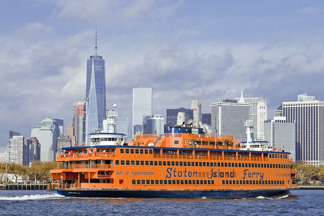
A recent Working Harbor Committee excursion to Gowanus Bay saw our vessel plying the Buttermilk Channel section of the East River, which is found between Red Hook and Governors Island. The legend about how this section of the river ended up being called Buttermilk Channel states that back in colonial times, it was so shallow at low tide that Red Hook farmers would herd cattle over to the island for safe keeping and free grazing. Dredging projects in the industrial era lowered the depth hereabouts, creating a shipping channel.
As our vessel moved along, a big orange boat called the Staten Island Ferry entered into Buttermilk, which is pretty unusual. Incidentally, despite its size, the Ferry is a boat. If it could launch a boat, it would be a ship, but since it can’t, it’s a boat. Life boats don’t count, I’m told.
– photo by Mitch Waxman
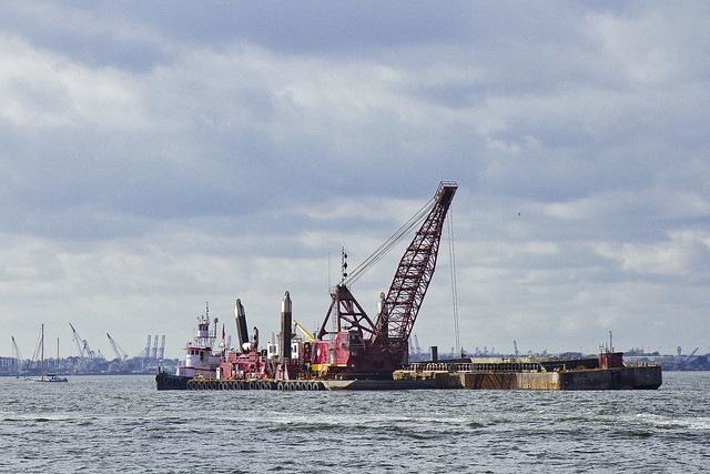
It was actually a dredging project that caused the anomaly. New York Harbor is an estuary situated between a giant conveyor belt for silt and soil called the Hudson River and the estuarial waters of Jamaica Bay and Long Island Sound. The back and forth tidal action of the East River, coupled with the titanic flow of the Hudson, causes the harbor floor to build up constantly and channel maintenance is an expensive but necessary activity ordained and financed by the ports people.
– photo by Mitch Waxman
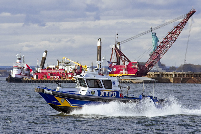
Just as we were leaving Buttermilk Channel on our way to Erie Basin and Gowanus Bay, the NYPD Harbor Patrol came splashing by, offering themselves up with an iconic backdrop.
“follow” me on Twitter- @newtownpentacle
nervous motion
Brooklyn, Manhattan, Williamsburg.

– photo by Mitch Waxman
As mentioned yesterday, one is taking a short break – hence the singular image which greets you above. Back soon with new stuff.
“follow” me on Twitter- @newtownpentacle
Upcoming Tours and events –
October 7th, 2015
Our Polluted History:
A Non-Toxic & Fascinating Forum on Greenpoint’s Environmental Past panel discussion
with GWAPP, click here for details
October 10th, 2015
Calvary Cemetery Walking Tour
with Atlas Obscura, click here for details and tickets
victoriously swept
If the bridge wasn’t there, it would be impossible to recognize Williamsburg, Brooklyn.

– photo by Mitch Waxman
Mephitic vapors, the effluent of furnaces and forges, a vague scent of molasses, and the smell of freshly smoked crack cocaine used to be all you needed to recognize where you were when visiting Williamsburg. These days, all you’ve got is the visual cue offered by its eponymous bridge and the vague scent of high end Marijuana.
Occasion found me in the ancient village, and as I was headed for Manhattan to meet up with a boat later in the day, a scuttle across the bridge was called for.

– photo by Mitch Waxman
A lot of people think this span is an architectural travesty, but I’ve never thought it was bad enough to to create a Municipal Arts Society over. There are “separate” pedestrian and bicycle paths, which aren’t really segregated from each other in any cohesive manner, but as one such as myself enjoys playing things “by the rules” – I found myself climbing the surprisingly steep ramp leading up from Brooklyn to the bridge itself. At least it provides for some fairly good “cardio.”

– photo by Mitch Waxman
Back in art school, the conventional wisdom imparted to me by a generation of instructors was that you can’t go wrong when there’s an umbrella in your shot. The reasoning is that the umbrella is an inherently interesting shape, and it breaks up the otherwise pedestrian points of view one normally encounters. It wasn’t raining, of course, and the umbrella was simply there to shield its wielder from the particularly powerful emanations of the burning thermonuclear eye of God itself whose gaze seemed fixed upon the bridge.

– photo by Mitch Waxman
All the tourists seem to flock to the Brooklyn Bridge, and its pedestrian path offers one a frustrating and crowded experience. It’s a bit like a lunch line at a buffet, that walk, a slow shuffle while trapped in a queue. Vast preference for the less popular bridges like Queensboro, Williamsburg, and Manhattan is offered by your humble narrator. Crowds suck.

– photo by Mitch Waxman
For this walk, I used my “crappy lens” – a 70-300 consumer level zoom. After the great camera disaster of July, wherein both camera body and my “best lens” were destroyed, I’ve been making it a point of mixing things up a bit. Thanks to many of you who donated money for replacement equipment to this blog, and both body and “best lens” have been replaced. Regardless, one tries to keep things fresh and the extra reach which the imperfect but serviceable “long lens” provides for slightly different perspectives and color rendition.

– photo by Mitch Waxman
It would be utterly pedantic to go into the technical details on this subject, so suffice to say that each and every lens interprets the light moving through it in different ways. Certain lenses are great for portraits, others for landscapes. Camera settings can also affect color rendition as well – for instance, narrow apertures render the color blue in a certain way due to the clipping of upper and lower limits found in the blue light wave.
As I said, technical and pedantic.

– photo by Mitch Waxman
Manhattan side of the Williamsburg Bridge, at Delancey Street, and looking back towards the infinity of Brooklyn.
The Williamsburg Bridge is 7,308 feet long (measuring between the cable anchor terminals) and the deck is some 118 feet wide. The height at the center of the bridge is 135 feet and each tower is 310 feet in height as measured from the East River’s high-water mark. It was originally called East River Bridge #3 when opened in 1903. Its architect was Henry Hornbostel, and the chief engineer who oversaw its construction was Leffert L. Buck.
“follow” me on Twitter- @newtownpentacle
Upcoming Tours –
September 3rd, 2015
Newtown Creek Boat Tour
with Open House NY, click here for details and tickets.
evil design
Getting around town, in today’s post.

– photo by Mitch Waxman
A humble narrator’s antipathy towards entering the rat infested bunkers of sweating concrete that underlie the megalopolis has been fully explored in prior posts at this, your Newtown Pentacle. What are you going to do, though? There’s really only one truly economical way to get around in our city, and the subway is it.

– photo by Mitch Waxman
You could drive, I suppose, but one such as myself lives a mere three stops out from the City center, and cannot imagine bearing the costs and pain in the neck that maintaining an automobile would entail. My solution has always been to rent a car when I need one, which is not that often. It’s an expensive caprice, but no where even close to paying annual insurance, gas, and paying for the inevitable parking tickets.

– photo by Mitch Waxman
One has been making a dedicated effort to use the MTA bus system in the last year, as many of the places which I’m headed for in Queens are not served by the Subway system (or if they are, I have to loop through all of Manhattan to get there from Astoria). For instance, getting to Ridgewood, a distance of less than 6 miles from Astoria, would necessitate a 50 minute ride on the M which would visit most of Manhattan and a significant chunk of North Brooklyn.

– photo by Mitch Waxman
Far and away, my favorite form of transit are the ferries, and in particular the giant orange ones. East River Ferry has ironed out a lot of the kinks in their service in the last year, btw, and there’s now a smart phone app which publishes a schedule and anticipated times of arrival at the various landings. You can also purchase tix via the app. The big orange boat is free, incidentally, and is amongst other things – the most popular tourist destination in NYC.

– photo by Mitch Waxman
One would enjoy using the rich man’s preferred mode of transit, if only as a diversion, but this mode of transportation is ridiculously expensive – something like $2,000 per hour.
The best way to see NYC is on foot, of course.
This Sunday, I’ll be leading a walking tour of the eastern side of Newtown Creek for Newtown Creek Alliance, btw. Tix are still available, see the links below for more info.
“follow” me on Twitter- @newtownpentacle
Upcoming Tours –
August 2nd, 2015
The Insalubrious Valley of the Newtown Creek – Bushwick & Mapeth Walking Tour
with Newtown Creek Alliance, click here for details and tickets.
August 8th, 2015
13 Steps Around Dutch Kills – LIC Walking Tour
with Atlas Obscura, click here for details and tickets


