Archive for the ‘Long Island City’ Category
some curse
Twirling, ever twirling.
– photo by Mitch Waxman
From HQ in Astoria, I’ve got several approach vectors to the various sections surrounding the Newtown Creek. Walking south on 39th street and making a right on Skillman Avenue takes me to Dutch Kills in LIC, for instance. 43rd street carries me across Sunnyside and towards the Kosciuszcko Bridge. South on 48th street will point my toes at Maspeth Creek and or the Grand Street Bridge. In all the cases above, one walks downhill out of Astoria to cross a low point at Northern Blvd. and then up a shallow hill and the ridge which Sunnyside sits on. After crossing a certain point, the declination of the land begins to slope back down towards the flood plains surrounding Newtown Creek.
Then there’s the Woodside Avenue/58th street path, which is what I call “good cardio.” What makes it good is that you are pretty much pulling up hill towards the Maspeth Plateau the entire way. On this path, you get to stop and consider the place marker on 58th street and Queens Blvd. installed by the Dept. of City Planning denoting the geographic center of NYC, walk along the walls of Calvary Cemetery’s second and third divisions, and dodge a lot of traffic. Fun.

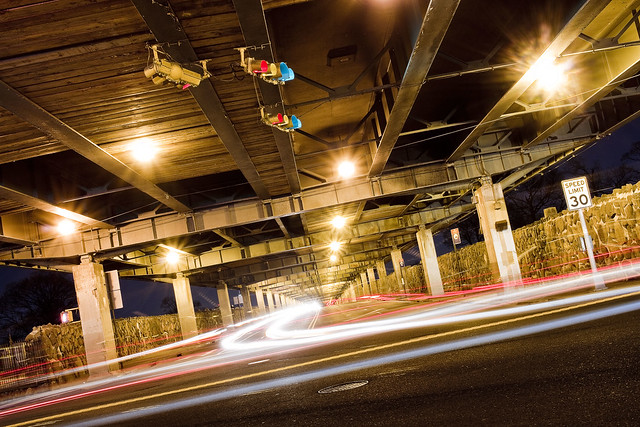
– photo by Mitch Waxman
Theoretically, the street pictured above is Laurel Hill Blvd., which is overflown by the Brooklyn Queens Expressway on an elevated ramp. Calvary 2 is on the north side of the street, Calvary 3 on the south. Both sections of the funerary complex sport high masonry walls which are somewhat oppressive, and are oddly free of graffiti. My understanding is that there is a street racing scene hereabouts on Laurel Hill Blvd., but I’ve never observed it. Recent experience has revealed that the fast and furious crowd currently prefers Review Avenue in Blissville, nearby Calvary 1, for their antics. To the North and East is the Woodside section, West and North is Sunnyside, and heading South brings you to Maspeth.
Oddly enough, this section of road is terrifically well travelled, even at night. It seems to be a bit of a shortcut for drivers, and the Q39 bus enjoys a couple of stops down here. As mentioned from a post a couple of weeks back, the State controlled highway which the street lamps are mounted on has not switched over to LED luminaires as the City has and old school sodium lights offer a now nostalgic orange glow.
– photo by Mitch Waxman
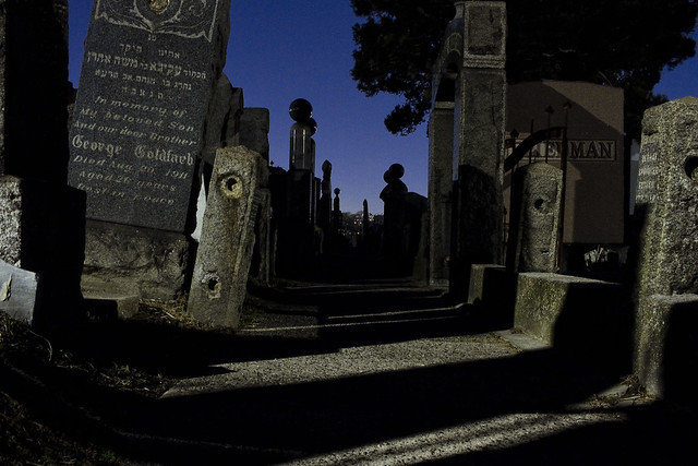
58th street itself, between the BQE and the Long Island Expressway, is essentially a trench running between two cemeteries – the aforementioned Calvary properties to the west and Mt. Zion to the East. Truly terrifying for a pedestrian, what passes for sidewalks are essentially earthen berms piles up against the cemetery walls.
Not everybody walks past a cemetery fence at night wishing that the property was open 24 hours, and regretful that the photographic splendors therein are out of reach, but I do. One couldn’t resist getting a few shots through the fence of Mt. Zion while picking my way along the rough hewn berm. Oh, to gain purchase within and spend time with the night gaunts and tomb legions.
“follow” me on Twitter- @newtownpentacle
Buy a book!
“In the Shadows at Newtown Creek,” an 88 page softcover 8.5×11 magazine format photo book by Mitch Waxman, is now on sale at blurb.com for $30.
those miniscules
Getting a clean shot.

– photo by Mitch Waxman
These shots were gathered during an interval of trespass, something which I advise everyone who asks against doing. In the foreground above is an inactive MTA rail bridge’s trackway, with the 1908 Borden Avenue Bridge at center frame and the 1939 Queens Midtown Expressway’s 106 foot tall truss bridge over the Dutch Kills tributary of Newtown Creek at top. It’s not easy getting the camera into position for a shot of the entire Borden Avenue span, I’ll offer, nor entirely legal to stand where it’s possible to do so. That’s why I was up here just before 8 in the morning on a Sunday, after all.

– photo by Mitch Waxman
Another shot for which one was risking a fine for is above, depicting a quite active Long Island Railroad Bridge called DB Cabin which is the gatekeeper to the Dutch Kills tributary of Newtown Creek. LIRR facilities in Long Island City go back 1870, and the 1893 vintage DB Cabin is meant to function as a movable swing bridge. When I first showed up on Newtown Creek about fifteen years ago, my pal Bernie Ente told me that he hadn’t seen it open in twenty years, so I guess that makes it thirty five non functioning years now.
DB Cabin connects the Lower Montauk tracks of the LIRR across the water. On the western side of the bridge is the Wheelspur Freight Yard, and on the east it feeds into the Blissville Yard.

– photo by Mitch Waxman
That’s the sort of view normally offered, gathered from the Borden Avenue Bridge.
Having gotten away with my naughty little mission, I headed towards the spot I was meant to meet the NCA crew at over on Skillman Avenue.
Tomorrow, something else, at this – your Newtown Pentacle.
“follow” me on Twitter- @newtownpentacle
Buy a book!
“In the Shadows at Newtown Creek,” an 88 page softcover 8.5×11 magazine format photo book by Mitch Waxman, is now on sale at blurb.com for $30.
utter extirpation
I had to make pee pee.

– photo by Mitch Waxman
While wandering around Dutch Kills, Long Island City’s (surviving) tributary of the fabulous Newtown Creek, one suddenly felt the call of nature. It was about six a.m. as I recall, when tolled the telltale alarum that it was time for a tinkle. Luckily, one had already secluded himself in a hidey hole along the banks of the waterway, one which offered both privacy and open unpaved soil. Why do I mention this, you ask? Because the City of New York completely and utterly disregards human biology in its various machinations and zoning decisions and has for better than fifty years. Why there isn’t a public pissoir found every mile or so is something that just escapes me. Luckily, as a bloke with an “outie,” the world offers lots of shadowed corners, spaces in between trucks, abandoned industrial canal bulkheads, and so on. I imagine the problems which proper renal function causes are more difficult for those of you with “innies.”
Anyway, as the sign in the shot would adjure – there’s meant to be “No Swimming’ here in Dutch Kills. Probably because of the millions of gallons of untreated sewage which the City dumps into every year.

– photo by Mitch Waxman
Of all the sections of Newtown Creek which one visits regularly, Dutch Kills is most frequently seen. It’s not too far from Astoria by foot. Most of the time I come here, however, is definitively later in the day than the one these shots were gathered – which was just as the burning thermonuclear eye of god itself was rising in the east. I kept on debating whether or not to use a lens filter to “slow down” the rising light levels a bit, but the actual scene was just so beautifully lit that I didn’t want to screw around with it too much. I did have the camera up on the tripod though. The settings for this one were f18, iso 100, and .6 of a second.
Why am I telling you that, just like why talk about having to take a piss? I’ll let you know pretty soon. That’s coy of me, ain’t it?
Also, ever think about that phrase “taking a piss”? If anything, you’re “giving” rather than taking one. British English uses “having” for the act, as a note. Doesn’t make sense to me, just like the flammable/inflammable conundrum.

– photo by Mitch Waxman
My eventual destination was going to be over on Skillman Avenue, where I was supposed to meet up with the Newtown Creek Alliance crew at nine. I still had plenty of time before that, so it was decided to shlep over to another hidey hole spot along Dutch Kills, one which is decidedly less private than the one so recently moistened by a humble narrator.
More tomorrow at this – your Newtown Pentacle.
“follow” me on Twitter- @newtownpentacle
Buy a book!
“In the Shadows at Newtown Creek,” an 88 page softcover 8.5×11 magazine format photo book by Mitch Waxman, is now on sale at blurb.com for $30.
multifarious items
Dutch Kills at sunrise, in today’s post.

– photo by Mitch Waxman
Breaking off in a generally northern direction, from the main course of the Newtown Creek, is its Dutch Kills tributary. Just under a mile in length, Dutch Kills is encountered about 3/4 of a mile into Newtown Creek from its junction with the East River, in Long Island City. Dutch Kill is crossed by five bridges – the railroad bridges DB Cabin and Cabin M, Borden Avenue Bridge, the Queens Midtown Expressway truss, and the Hunters Point Avenue Bridge.
Recent obligation found one scheduled to meet up with my chums from Newtown Creek Alliance at 9 am on a Sunday nearby Dutch Kills, in pursuance of us walking it and discussing the near future hereabouts.
Since I set the standard for sanity in this world, much like Caligula once did, I got there four hours early, and some two hours before sunrise. I set up the tripod and started getting busy roughly 5:30 a.m.

– photo by Mitch Waxman
Funnily enough, and photographers don’t normally say things like this, I was unhappy with how abundant the ambient light was. I’ve been spending so much time working in near total darkness of late that it’s almost become rote. Having to constantly figure out new exposure triangles every ten minutes got annoying.
Pictured are Cabin M, in the foreground, and DB Cabin. They are two of those five bridges mentioned above, and are both railroad bridges owned by the Long Island Railroad. Cabin M, which these days carries mostly graffiti, is meant to be demolished according to this year’s MTA capital budget plan. It connects the Blissville Rail Yard and the very active Lower Montauk tracks along Newtown Creek to the deactivated Montauk Cutoff tracks leading to the Sunnyside Yards.

– photo by Mitch Waxman
Looking north east from another span over Dutch Kills – the Borden Avenue Bridge – towards the 106 foot tall Queens Midtown Expressway truss bridge. In the distance is a Fed Ex ground shipping center and the Degnon Terminal IBZ.
Even though the light was becoming uncomfortably stronger, one hung around and kept on shooting all morning waiting for the Newtown Creek Alliance crew to arrive for our appointed round. More tomorrow.
“follow” me on Twitter- @newtownpentacle
Buy a book!
“In the Shadows at Newtown Creek,” an 88 page softcover 8.5×11 magazine format photo book by Mitch Waxman, is now on sale at blurb.com for $30.
vague presentiment
Mighty, Queensboro… and I guess I’m a troll now.

– photo by Mitch Waxman
One of my recent jaunts, carrying the camera about, found me wandering around the footings of the Queensboro Bridge in LIC. The amount of wasted space under here, which is frankly squandered by the NYC DOT, is colossal. DOT has the whole area gated off, with utilitarian fencelines of the chain link type bearing signage warning passerby of non existent security, and the city block sized lots under the bridge are used as parking lots for DOT’s municipal vehicle fleets, storage areas for various sorts of equipment like bike racks and tables, or they just sit empty.
For an area that’s so visually interesting, and so close to the largest of the NYCHA campuses, not having some combination of playgrounds and sitting areas… or even a single sign talking about Lindenthal and 1909… bah.
Trolls hang out under bridges, right?

– photo by Mitch Waxman
I’ve got a special place in my three sizes too small heart for Queensboro, as the centennial for her was the first time that I participated in a public event. A humble narrator was a Parade Marshal for that event, and in fact, the very first post at this – your Newtown Pentacle – carried a shot from the upper roadway shot on that day. That’s the first and only time I got to meet Mayor Bloomberg, the first time I interacted with Congresswoman Caroline Maloney, Borough President Helen Marshall, or then DOT Commissioner Jeanette Sadik Khan.
In many ways, it was my coming out party.

– photo by Mitch Waxman
Now, I’ve been bringing the thunder to Western Queens ever since, of course, but yeah Queensboro’s Centennial was the first time I stood up out of the shadows and said “Hi.”
Pictured above is one of those monumental wastes of space discussed above, a mostly empty parking lot for some of DOT’s fleet of passenger cars. Ever wonder why the DOT doesn’t require its people to ride bikes? I mean, institutionally speaking, they are the ones pushing the whole “bike lane agenda” in cooperation with the almighty TA Bicycle Lobby. You’d think they’d be providing some sort of moral example by abandoning their cars and riding bikes. The bike lobby is pushing the slogan that “street parking is theft,” right? So… what would you call that parking lot pictured above? Wouldn’t something else be a better use of the public land?

– photo by Mitch Waxman
There’s an intricate web of ramps leading onto and off of Queensboro Bridge at the western side of Queens Plaza. You’ve also got structural steel aqueducts that carry subway lines to and from the area. The streets are pretty high volume as far as private vehicle traffic goes as well. It’s not terribly pedestrian friendly down here.
Ever notice how the pedestrians always get left out of the argument? Most people walk to and from either their cars or their bikes, as a note, and there’s some like myself for which walking is their primary manner of getting around. Saying that, it’s all about parking versus bike lanes.

– photo by Mitch Waxman
On the bike lane front, a significant amount of conversation in the coming months is going to involve Crescent Street. The bike people, and the elected officialdom crowd, have started a process which is calling on the NYC DOT to study creating a “bridge to bridge” bike lane on Crescent Street which will negate a lot of parking, reduce the number of vehicle lanes on the southern side of the street down to one, and create a protected bike lane. It’s not necessarily the end of the world, as some would offer, and not necessarily the solution to all things as others would say. What it is, however, is problematic in terms of engineering the street’s ultimate flow of both motor vehicles and bikes onto Queensboro.
Pity me, I’m going to be right in the middle of this on Community Board 1’s Transportation Committee.

– photo by Mitch Waxman
That’s the 7 line subway tracks pictured above, and the streak of light exiting stage left is the line itself. Cannot tell you how long I stood on this corner waiting to get this shot, but I can tell you it was pretty chilly out and that shortly after the capture above, rain started to drizzle down. One headed over towards the north side of Queens Plaza, whereupon I discovered that the R line had been shut down for the night due to repairs and that MTA was running a shuttle bus instead. Luckily for me, that shuttle wasn’t asking for a swipe of the old Metro Card, so I got a free ride home.
Tomorrow, back to the fabulous Newtown Creek, at this – your Newtown Pentacle.
“follow” me on Twitter- @newtownpentacle
Buy a book!
“In the Shadows at Newtown Creek,” an 88 page softcover 8.5×11 magazine format photo book by Mitch Waxman, is now on sale at blurb.com for $30.


