Archive for the ‘Maspeth’ Category
quite convinced
– photo by Mitch Waxman
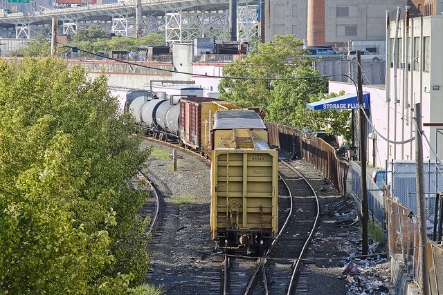
Recent financial setbacks and personal problems infect your humble narrator with a form of deep melancholy and a vast ennui. When such moments come upon me, there is a certain pizzeria in Greenpoint (Norman corner of Manhattan, near the train) whose offerings can be summed up best as: an actual and old fashioned “Brooklyn Slice”. On the day I spied this collection of rail cars at the so called “Bliss Tower” in DUGABO, I had scuttled forth from the rolling hillocks of my beloved Astoria in pursuit of one of these aforementioned slices, in an effort designed to brighten my mood.

– photo by Mitch Waxman
Errors and omissions mar my record when discussing the Rails, much to the chagrin of the knowledgable railfan community (whose helpful comments and corrections are always appreciated here at Newtown Pentacle). As such, what I can categorically tell you is that this a New York & Atlantic Locomotive, one of the 11 engine units which service the 269 miles of track operated upon by the Glendale based company in Brooklyn, Queens, and both Nassau and Suffolk counties. It shares much of its road with the passenger based Long Island Railroad, and NY&A’s distinctive emerald, white, and black engines are regularly observed around the Newtown Creek.

– photo by Mitch Waxman
Across the Newtown Creek Watershed, one encounters a landscape built for rail. Long abandoned track beds lie buried in inches of road asphalt, pointing the way to industrial giants long absent. Train stops orphaned from their purpose, spars and switches which were rudely severed to make room for modernity. All of it operated at street grade, and the remnants of the iron road are often the only tangible remains of great concerns and financial largesse. If you follow the right spar, you’ll discover that the NYPD Barricades unit was once Thypin Steel, or that LaGuardia Community College was once the Loose Wiles bakery and part of the Degnon Terminal.

– photo by Mitch Waxman
Within the communities which surround the Newtown Creek, a complaint often repeated concerns the presence of large numbers of trucks utilizing local streets in their quest to move goods from A to B. I had the privilege last year of attending a presentation by certain factions within the Port Authority that described a proposal which would eliminate several thousand truck trips a day throughout the City and over the George Washington Bridge, simply by shipping New York City’s garbage out to land fill utilizing locomotive rather than automotive means. Calculations about air pollution, road maintenance costs, and vehicular accident rates were presented at the time which compared rail quite favorably with truck based shipping.There was a maritime component to the plan as well, which was a bit hazy, but the train concept was spun gold.

– photo by Mitch Waxman
The shot above represents an NY&A Locomotive making a drop off of a customer in Maspeth near the ill fated St. Saviour’s church site, where they will uncouple a car or two for the unloading or loading of certain cargo. An unthinkable amount of trucks would be required to carry the same tonnage. The subject of Green Technology and “Greening New York” is often bandied about by many these days. Too much of the conversation, however, is “cocktail party environmentalism”- which sounds great but just isn’t practical on a policy level.
I’ve developed this funny notion, however, that the way forward is actually to re-imagine and re-invent the heaviest industry of them all.

– photo by Mitch Waxman
Rail infrastructure is what made Long Island City the factory of not just New York, but the entire world at the turn of the last century and multiple generations of capitalists and real estate interests founded vast fortunes because of the initial investment in it. Newtown Creek was the busiest waterway in North America, carrying more ship and barge traffic than the entire Mississippi for a time, and all of that maritime activity was fed by rail. Intermodal rail floats actually carried whole trains across the harbor to Manhattan, Staten Island, New Jersey and beyond. Imagine the benefits, in both individual wealth and environmental health, were we to try and save the future by looking for solutions in the past.
I’m still kind of forming this idea up for myself, but the key to it is containerization. More on this soon.
What do you, lords and ladies, think on the subject? Use the comments “Reply box” below, if you would like to start a conversation about it.
…hits the fan

– photo by Mitch Waxman
Council Member Van Bramer sent this out to his mailing list today, regarding Hurricane Irene
As everyone knows by now, Hurricane Irene is expected to hit our area sometime Saturday into Sunday. We should all take precautions to be prepared for a storm of this magnitude. Some areas in our district are in evacuation zones and at high risk for flooding. Those areas of Hunters Point/Long Island City should familiarize themselves with the map below and know that should an evacuation be ordered, Newcomers High School (28-01 41st Ave.), Aviation High School (45-30 36th St.) and W.C. Bryant High School (48-10 31st Ave.) are your nearest evacuation centers. The City will make a decision about whether to order a mandatory evacuation of Zone A for the general public by 8:00 AM on Saturday. The evacuation centers will be open as of 5:00 PM today and the City is strongly recommending that people within these areas immediately make plans to go to alternative locations outside of Zone A starting tomorrow for the duration of the storm. The orange areas are Zone A. The yellow areas are Zone B. The green areas are Zone C.

We are also concerned about significant portions of the district including parts of Sunnyside, Woodside, Astoria and Maspeth that have experienced flooding during several recent storms. Our office has been and will continue to be in contact with the Department of Environmental Protection (DEP) and other city agencies throughout this weekend. Anyone experiencing difficulties as a result of Hurricane Irene should contact me and my office as soon as they occur. We will report problems in real time. For those outside of Zone A areas that have experienced flooding or are concerned that you may, please click on the link below on how to protect your valuables. In addition to calling our office, DEP is asking for reports of flooding to be called in to 311.
http://home2.nyc.gov/html/oem/downloads/pdf/flooding_guide.pdf
I have also been in touch today with NYCHA and the Mayor’s Office to make certain that Queensbridge, Ravenswood, and the Woodside Houses are included in any and all emergency plans including evacuation, should that be necessary. We will continue to be in regular contact with NYCHA throughout the storm.
While we continue to hope for the best, we must prepare for the worst. The city has published some useful information in securing your home during the storm. Please click on the link below for recommendations on how best to prepare for the hurricane.
www.nyc.gov/html/oem/html/ready/hurricane_guide.shtml
Given the high volume of traffic to OEM’s (Office of Emergency Management) website there have been delays and interruptions in gaining access to some of these links. For that reason, we also include the Red Cross’ Hurricane Safety Checklist below. We have also included information from OEM’s Hurricane Guide at the end of this email should that link not respond when you try it.
http://www.redcross.org/www-files/Documents/pdf/Preparedness/checklists/Hurricane.pdf
In advance of the hurricane I wanted to remind you that clogged catch basin grates can aggravate flooding. Although DEP staff – with the help of their colleagues at other agencies – are busy cleaning catch basins now, DEP has asked us to remind homeowners and residents that they welcome assistance in removing leaves, litter or other debris that may prevent water from flowing off the streets and into the catch basins. For any of you that aren’t familiar with catch basins the attached link to a page on DEP’s website has some text and visuals that will help explain why flooding occurs and how citizens can help DEP minimize flooding by removing debris where they see it blocking catch basin grates.
http://www.nyc.gov/html/dep/html/flooding/flooding_causes.shtml
I will be keeping my district office open on Saturday to field questions and concerns from constituents. Needless to say, we will close the office when the storm approaches and will reopen as soon as it is safe to do so. My district office number is (718) 383-9566. I will be in the district throughout the storm and encourage anyone with problems to email me concerns at jvanbramer@council.nyc.gov as well as using social media including Facebook (http://www.facebook.com/jimmyvanbramer) and Twitter (http://twitter.com/jimmyvanbramer) to reach me. You may also call 311. Please only call 911 if you have a very serious or life threatening emergency.
I hope this update and the attached information proves useful to you. Again, my staff and I will be working throughout the weekend and please do not hesitate to contact me should you need assistance.
Sincerely,

Jimmy Van Bramer
Council Member

– photo by Mitch Waxman
Additionally, the Council Member included the following information from the Office of Emergency Management
OEM’s Hurricane Guide
To secure your home if a tropical storm or hurricane watch is issued:
Bring inside loose, lightweight objects, such as lawn furniture, garbage cans, and toys.
Anchor objects that will be unsafe to bring inside, like gas grills or propane tanks. Turn off propane tanks.
Shutter windows securely and brace outside doors.
Place valuables in waterproof containers or plastic bags.
Help Others Prepare
- Check on friends, relatives, and neighbors, especially those with disabilities or special needs, and assist them with their preparation and evacuation.
- If you live outside an evacuation zone, offer to shelter family and friends who may need to evacuate.
If Asked to Evacuate, Do So Immediately
The City will communicate specific instructions about which areas of the city should evacuate through local media. If the City Issues an Evacuation Order for Your Area: Evacuate immediately. Use public transportation if possible.
If you are going to an evacuation center, pack lightly, and bring:
- Your Go Bag
- Sleeping bag or bedding
- Required medical supplies or equipment
- Let friends or relatives know where you are going.
What about my pets?
- Make sure your disaster plan addresses what you will do with your pet if a hurricane requires you to leave your home.
- Plan to shelter your pet at a kennel or with friends or relatives outside the evacuation area.
- Be sure you have supplies ready for your pet in the event of an evacuation, including food, a leash, a muzzle, proof of shots, and a cage or carrier.
Account for your special needs
- Consider your capabilities and make sure your preparedness plan addresses how your special needs affect your ability to evacuate and shelter.
- Determine if you will need assistance and arrange help from friends, family, or neighbors.
- Consider additional supplies and equipment that you may need to bring with you, such as medicine, icepacks, medical devices, and backup equipment. Bring food for your dietary needs.
- Include additional time and evaluate your transportation options.
IF YOU LIVE IN AN EVACUATION ZONE
Prepare A Disaster Plan
Develop a plan with your household members that outlines what to do, how to find each other, and how to communicate if a hurricane strikes New York. If you rent your home, renter’s insurance will insure the items inside your apartment. If you are a homeowner, make sure your home is properly insured — flood and wind damage are not covered in a basic homeowner’s policy.
Know Where You Will Go
The City strongly recommends evacuees stay with friends or family who live outside evacuation zone boundaries. For those who have no other shelter, the City will open hurricane shelters throughout the five boroughs.
To ensure efficient use of resources, the City will ask all evacuees to report to an evacuation center. Once at the evacuation center, evacuees will either be assigned to a hurricane shelter in the same facility or transported to an associated hurricane shelter by bus.
Every household member should have a small Go Bag — a collection of items you may need during an evacuation packed in an easy-to-carry container such as a backpack. A Go Bag should be easily accessible if you have to leave your home in a hurry.
Assemble an Emergency Supply Kit
You may be instructed to shelter in place (stay at home) during a hurricane. Keep enough supplies in your home to survive for at least three days.
If you do not live in an evacuation zone
All areas of the city could face hurricane-related hazards such as high winds, flooding, tornadoes, and loss of utilities. You may be instructed to shelter in place (stay at home) for several days until the hurricane passes.
If you live in a high-rise apartment building
Residents of high-rise apartment buildings may face special risks from hurricanes even if they live outside evacuation zone boundaries. If you live in a high-rise building outside an evacuation zone, be prepared to take shelter on or below the 10th floor. If you live in a high-rise building located in an evacuation zone, heed evacuation orders.

– photo by Mitch Waxman
This looks like it will be a profound event. Personally, I’m preparing for an uncomfortable few days, but that’s because I live inland and uphill in Astoria. Long Island City and Greenpoint on the other hand…
Our friends at liqcity.com have prepared an excellent posting on the Zone A situation, which can accessed here:
http://www.liqcity.com/life/long-island-city-and-hurricane-irene-a-match-made-in-well-well-see

– photo by Mitch Waxman
Newtown Creek Alliance, an organization of which I’m a member, issued this statement earlier today…
Flood Warning for Creek Neighborhoods
Mayor Michael Bloomberg announced on August 25th, 2011 that certain emergency measures will be instituted in low lying coastal districts referred to as “Zone A” (at high risk of coastal flooding) due to the expected arrival of Hurricane Irene in the New York City area late Saturday night. Much of the land surrounding Newtown Creek is designated as “Zone A” on the coastal flooding map prepared by City officials, including large tracts of Greenpoint and Long Island City. For a map of the affected areas, please click here.
Newtown Creek Alliance cautions residents of the affected areas to monitor the situation and be prepared to evacuate should authorities warrant it necessary. If an evacuation is recommended or ordered, information about evacuation centers and hurricane shelters may be found by calling 311 or at by visiting this website. Additionally, be mindful that during such an event, the flood waters could carry a significant load of pollutants and should not be ingested. Care should be taken upon any contact with skin.

– photo by Mitch Waxman
Sources within the City have discussed this storm with me in the most dire tones. If you live in an area designated for evacuation, please comply. I’ll be marching out into the brave new aftermath early Monday morning, if there’s something which you think I should point my camera at, please contact me here. Good luck, and assuming the availability of both electrical power and internet connectivity, I’ll post as the situation develops.
As this post was being prepared, Council Member Van Bramer passed along another message, ordering the mandatory evacuation of Zone A by 5 pm Saturday.

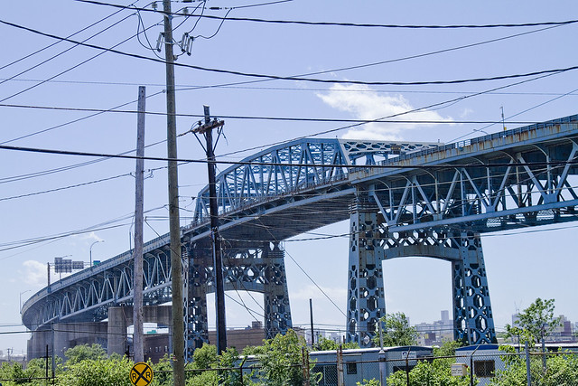
Happy Birthday, Kosciuszko Bridge

– photo by Mitch Waxman
A virtual guarantee is offered that this is the only posting you will see today commemorating and wishing the Kosciuszko Bridge a happy 72nd birthday. Some 26,298 days ago, Robert Moses saw the first link in a crazy idea of his which would one day be called the “Brooklyn Queens Connecting Highway” open for business.

– photo by Mitch Waxman
The Meeker Avenue Bridge opened on August 23rd, 1939 (renamed in 1940 as The Kosciuszko Bridge) – some 631, 152 hours ago. It was promised to allow easy egress to the World’s Fair, and was a showpiece project for the Great Builder.

– photo by Mitch Waxman
From a Newtown Pentacle posting of December 8, 2010– in which the big K was described as thrice damned:
Damned Once- The Kosciuszko Bridge catches radio frequency emissions from several nearby commercial radio broadcast antennas. A lot of it.
Whatever knows fear burns at The Kosciuszko Bridge’s touch.
Damned Twice- The Kosciuszko Bridge is at extreme risk in the eventuality of a seismic event. The Brooklyn pier actually sits on the Creek bed, some 6 meters below grade, but the Queens side is anchored on piles driven into the mud. The hard soil around Queens Plaza will merely shake, but the land surrounding the Newtown Creek will liquify.
Damned Thrice- The Kosciuszko Bridge once had pedestrian walkways, but they were removed in 1961. Can you imagine what kind of photos would be possible on a pedestrian walkway 124 feet over the Newtown Creek?
– photo by Mitch Waxman
Like many things and people who are 72 years old, the Kosciuszko Bridge is not long for this world. Why not raise a glass to it tonight, and acknowledge its long service to the City?
Click here for a sentimental slideshow of the old girl from the last couple of years
paramount desire

– photo by Mitch Waxman
The final series of images which were discovered on my camera card, product of a trance like “Grand Walk” which carried me through an ancient corridor of the megalopolis, corroborated my theory that indeed- all roads always have and always will lead to Calvary.
Calvary Cemetery hosts the hoary remnants of an ancient clan of Anglo Saxons called the Alsops, who are buried in a family plot maintained as separate and distinct from the necropolis which surrounds it. Protestant land, officially, the earliest grave found here is meant to be the one housing the sire of the line- that of Thomas Wandell, but if there was ever a marker it is long vanished.
There are several members and generations of the Alsop family interred here, alongside their unnamed and oft unmentioned African slaves in this hidden corner of the Newtown Pentacle.
The oldest stone extant is that of Richard Alsop, a crumbling example of the carvers art which dates to 1718.
from The Eastern District of Brooklyn By Eugene L. Armbruster, courtesy google books
The Alsop farm, on the Queens County shore of the Newtown Creek, was the grave of Thomas Wandell, the former owner of the farm, who died in 1691. A large part of the farm became the site of Calvary Cemetery, but the Alsop family burial ground, by a reservation to the family, still remains Protestant ground.

– photo by Mitch Waxman
Alsop was quite a fellow by all reports, a very public man who acted as judicial magistrate and executor of inheritances for the simple farmers of Newtown. One of his descendants, John Alsop of Connecticut and Long Island, was a delegate to the Constitutional Conventions which initiated the “American experiment” in the 1770’s and 80’s.
The last of the Alsop line in Newtown – also named Richard Alsop- died without heirs, and a vast plantation estate that stretched along the then vernal Newtown Creek was offered up for sale.
It found interested buyers in a group of Irishmen hailing from Mulberry Street, across the river in New York, who worked for a large firm headquartered in Rome.
from Publication Fund series By New-York Historical Society, courtesy google books
Thomas Wandell, Maspeth Kills. “The last will and Testament of Thomas Wandell of Maspeth Kills in the bounds and limits of Newtown upon Long Island; being subject to sudden sickness and knowing the certainty of death.” Leaves all estate, except the following legacies, to his wife Audry Wandell, and makes her his sole executrix.
I leave to my cousin Richard Alsop, the piece of salt meadow that lieth within his fence, that incompasseth his dwelling house.
Also 2 steers and a case of pistols already in his possession.

– photo by Mitch Waxman
Long has your humble narrator desired to look upon the monument of “he who must not be named” and the long journey which carried me here actually began when I was contacted via “electronic mail” by a stranger who claimed to possess first hand information- an actual burial plot address here at Calvary.
He described himself as belonging to a faction of the “Ancient Order of Hibernians” which had splintered away from the mainstream group in 1921 over a silly doctrinal dispute. His forebears had stored away a copy of the burial and business records of Calvary Cemetery, a singular item since the original documents possessed by the Church were immolated in an outwardly suspicious fire.
Insisting that our meeting be privately attended yet in a public place is what led me to St. Patrick’s Old Cathedral in the first place, a seemingly natural location given the circumstances, and one that might provide certain literary symmetries if the story was later told.
As is habitual for one like myself, an attempt was made at an early arrival, and when my appointee arrived- he was not alone nor was he unobserved.
from Historical records and studies, Volume 1 By United States. Catholic Historical Society, courtesy google books
In the meeting of trustees, Sept. 19, 1845, it was announced that the Alsop Farm, consisting of about 115 acres, in Newtown Township, Long Island, had been secured for a cemetery. The deeds are dated Oct. 29, 1845. On July 31, 1848, at a special meeting of the board, it was resolved that “the cemetery at Newtown Creek, recently consecrated in part, should be called Calvary, and placed at the disposal of the public; that after August 2d the 11th Street burial-ground, as well as the free vault at 50th Street, should be permanently closed.”
Calvary Cemetery began to be used August 4, 1848. The first interment was that of Esther Ennis. Sections 1, 2, 3, 4, and 5 had been previously blessed. No record is preserved, however, of the ceremony.
Formerly, as is well known, every farm had its ” wood-lot” for fuel. The Alsop Farm had reserved 11 acres for this purpose, and the wood-lot has remained undisturbed to the present time. About 30 acres, lying in low ground near the water, were sold many years ago. The remaining 73 95-100 acres of the original Alsop Farm were devoted to and are still used for cemetery purposes.

– photo by Mitch Waxman
It was the sight of his companions that shocked me into flight, as reported in the first post of this series, and I will confess to experiencing a sort of racism that has nothing to do with national origin or ethnicity having been kindled in me. Rather than ethnographic it was something ancestral and instinctual, a genetic memory of some other specie of intelligent ape which our wholesome ancestors saw fit to exterminate in some long ago savannah.
I’m not altogether sure that these 2 companions of his were members of the “human race” itself, you see – with rounded jowls and underdeveloped chins they appeared to have a snout rather than a face- and what hung hairily beneath their wrists are better described as paws rather than hands. Their clothing was unseasonable and several years behind current fashions- flannel jackets and watch caps worn on a warm summer afternoon. The Anti Hibernian I was meant to meet did most of the talking in low whispers, and hoarse grunts were the only responses the two man shaped creatures offered in return which I could make out.
The exact moment which brought on this latest surrender to “one of my states”, triggering a multiple hour flight which carried me across half of New York City in a foot blistering haze, happened when I was peeking out from behind one of the columns at St. Patrick’s Old Cathedral in the manner of some mouse who has just noticed the presence of predators.
also from Historical records and studies, Volume 1 By United States. Catholic Historical Society, courtesy google books
At present there are over five miles of flag walks in Calvary. The cost of the headstones, monuments, etc., is roughly estimated as exceeding $6,000,000. A force of about 150 men is constantly occupied in attending to the burials, adapting and preparing the grounds for future use. A characteristic feature of Calvary, as of all Catholic cemeteries in contradistinction to large burial corporations formed with a view to personal profit, is the provision made for the benefit of the poor and destitute. According to the direction of the ritual and the spirit of Christian charity, the needy are interred as a work of mercy. In fact, more than one tenth of all the burials are gratuitous.
The entire number of interments since the opening of the cemetery in August, 1848, to January, 1898, is 644,761.

– photo by Mitch Waxman
Bits of it, like words on the tip of your tongue, are available to me as fragmented images lensed through the curious distortions of a migraine headache….
- A metallic cylinder of some kind, the thickness of a young child’s index finger, passing between the man who contacted me and his conspirators.
- The oddly green color and outmoded cut and style of the sports jacket worn by the man I was meeting, gaudily ornamented with a purple blossom of unknown breed which emitted a sickly lemon like smell
- The odd juxtaposition of muddy workman boots worn under suit pants seemingly chosen to match the flower.
- The horrible countenance and bestial appearance of his companions, augmented by the jiggling folds produced where their jowled necks became occluded beneath shirt collar.
from the Friends’ intelligencer, Volume 35, courtesy google books
The early history of Friends in Newtown and Maspeth Kills is marred by the irregularities of the Ranters, who claimed to be Friends, and intruded on their meetings.
Such was Thomas Case, who (1674) was forbidden by the Court to entertain the wife of William “Smith. His wife, Mary Case, was fined £5 for interrupting Rev. William Leveridge, while preaching, by saying to him: “Come down, thou whited wall that feedest thyself and starvest the people.” Samuel Scudder sent a long, scandalous letter to Mr. Leveridge.
The Court put Case and Scudder under bonds not “to seduce and disturb the people.”

– photo by Mitch Waxman
But this was not the least, for the event which set off my spell is also contained in one of these glimmer images…
I noticed that all three bore that unmistakable colour often commented on around the Newtown Creek, an iridescent hue which is neither black nor white nor any recognizable color of the wholesome earth, rather it is something alien- like a colour out of space.
When one observes this colour, especially within the elite corridors and behind the mirrored shield wall of the Shining City of Manhattan itself, it is obvious that something from the tainted Creeklands is nearby.
from The annals of Newtown, in Queens County, New York, containing its history from its first settlement, together with many interesting facts concerning the adjacent towns, courtesy openlibrary.org
Mr. Wandell, according to reminiscence in the Alsop family, had been a major in Cromwell’s army ; but, having some dispute with the protector, was obliged to flee for safety, first to Holland, and thence to America.
But some doubt of this may be justly entertained; because Mr. Wandell was living at Mespat Kills in 1648, which was prior to the execution of King Charles, and when Cromwell enjoyed but a subordinate command in the parliamentary army. Mr. Wandell m. the widow of Wm. Herrick, whose plantation on Newtown Creek, (originally patented to Richard Brutnell,) he bought in 1659, afterwards adding to it fifty acres, for which Richard Colefax had obtained a patent in 1652.
On this property, since composing the Alsop farm, Mr. Wandell resided.
He was selected, in 1665, as one of the jury for the trial of Ralph Hall and his wife for witchcraft, (the only trial for witchery in this colony,) and shared the honor of acquitting the accused. Some years later, he made a voyage to England, returning by way of Barbadoes, and, it is supposed, brought with him from England his sister’s son, Richard Alsop, who, about this time, came to America, and was adopted by Mr. Wandell as his heir, he having no issue. He d. in 1691, and was interred on the hill occupied by the Alsop cemetery.
Many years after his death, the silver plate of his cofiin was discovered, in digging a new grave.

– photo by Mitch Waxman
That malign and impossible intelligence which cannot possibly exist in the crown of this “Sapphire Megalith of the Long Island“, a thing which neither thinks nor breathes but instead hungers, gazing down on the folly of knowing the past and chuckling deeply (it does laugh, I am told). Protected and coddled by its mercenary army of human acolytes, it must wonder “what profit can there be in these pursuits?”.
And in the deep past- hidden behind the orthodoxy of 20th century historians- are found hidden references to Hannah Alsop (widow of Richard) having hosted meetings of so called “Friends” (Quakers in modernity) on the Alsop plantation. A nameless cult of some kind, these apostates are remembered only by their presence along Newtown Creek, troublemaking further east on Long Island, and by the colloquial name of “Case’s Crew”.
from Potter’s American Monthly, Volume 1, courtesy google books
There had scarce been any profession of the christian religion among the people of that town. They had scarcely any notion of religion but Quakerism. The Quakers had formerly a meeting there; but many of them became followers of Tho’s. Case, and were called ‘Case’s Crew,’ who set up a new sort of Quakerism, and among other vile principles, condemned marriage and said it was of the Devil, perverting that text of Scripture. ‘The children of the resurrection neither marry nor are given in marriage,’ and they said ‘they were the children of the resurrection.
‘ This mad sort of Quakerism held that ‘they were come already to the resurrection and had their vile bodies already changed.'”
suitable apparatus
– photo by Mitch Waxman
As the redolent cargo of my camera card revealed- this “Grand Walk”, a panic induced marathon which carried your humble narrator across the East River from St. Patrick’s Old Cathedral in Manhattan into Williamsburg and up Grand Street to Maspeth and the baroque intrigues of the Newtown Creek– wound down into it’s final steps on Laurel Hill Blvd.
Examining the images recorded on my camera, photos which I don’t remember taking, the ineluctable feeling that something was missing from the modern scene was inescapable.
from wikipedia
Nichols, along with his son Charles W. Nichols, helped organize the merger of 12 companies in 1899 to create General Chemical. Under his leadership, the company grew its asset base and increased its earnings threefold, making Nichols a force in America’s fledgling chemical industry. His vision of a bigger, better chemical company took off when he teamed up with investor Eugene Meyer in 1920. Nichols and Meyer combined five smaller chemical companies to create the Allied Chemical & Dye Corporation, which later became Allied Chemical Corp., and eventually became part of AlliedSignal, the forerunner of Honeywell’s specialty materials business. Both men have buildings named after them at Honeywell’s headquarters in Morristown, New Jersey. His original plant along the Newtown Creek in Queens is infamous for its legacy of pollution. Nichols is rumored to have once emptied vats of excess sulfuric acid into the creek rather than sell it cheaply to a businessman he had no respect for.

– photo by Mitch Waxman
Nichols Chemical, from which the legendary Phelps Dodge Laurel Hill plant would someday sprout, would have been found along the Newtown Creek nearby the thrice damned Kosciuszko Bridge – which is itself doomed and consigned to the stuff of future reminiscence. At it’s apex, this industrial site employed 17,500 people and squatted along some 36 square acres of the Creeklands.
The tallest chimneys in the United States (at the time) stabbed at the sky from here, painting the Newtown sky with poison effluvium whose pH content was sufficient to cause marble and granite to melt like ice cream left to the merciless gaze of the burning thermonuclear eye of god itself.

– photo by Mitch Waxman
The Kosciuszko Bridge is slated for demolition and replacement in a few short years of course, and this scene will irrevocably alter when a modern structure is put in place. The high flying bridge was built large to accommodate the sort of ocean going craft which were common in the 1930’s- cargo and passenger vessels with enormous smokestacks that would have been serviced and outfitted by other corporations just up the Creek.
Additionally, the war department held certain intentions and reserved the option to sequester battleships in Newtown Creek, with the intentions of protecting the vital industrial center from a safe inlet, were an invasion of North America attempted by hostile European adversaries via New York Harbor.
When a manufacturing establishment decides to increase its output fivefold; when it decides to tear down its present buildings and put up new ones; and when it owns valuable waterfront which is marketable at a high price, that concern considers carefully the question whether it will remain in its present location or move to some other. Now our friends above mentioned would doubtless at once aver that, if this concern was a New York concern and found itself in this situation, there could be but one answer—”To Jersey for us”— or to some other place near land’s end where land can be purchased for a song, where government regulations are unknown and where, in addition, the manufacturer would find himself surrounded by a great and aching void.
But all these prophesies are as wormwood and the pessimists are confounded. Over In the wilds of Queens there Is a place—look it up on the map—called Laurel Hill.
Laurel Hill is not a place of beauty. The undulating hills in them neighborhood are covered with cemeteries, rocks, and ugly houses and through the midst of it all (lows the far-famed Newtown Creek, covered at all times during the day and night with busy water craft. But Laurel Hill is one of the most important manufacturing districts in Greater New York and Newtown Creek is one of the foremost commercial arteries in or about NewYork City.

– photo by Mitch Waxman
One of the aphorisms which has emerged in my studies of Newtown Creek and the surrounding communities is this: “all roads lead to Calvary“.
Whether it be ancient ferry lines which fed the street car roads, or the occluded pathways of the aboriginal Mespaetche and Decadent Dutch, all the roads of western Queens and North Brooklyn point inevitably to this spot. Semi conscious during this “Grand Walk”, your humble narrator nevertheless found himself at the corner of Laurel Hill Blvd. and Review Avenue once again, standing before the great and sacred Polyandrion of the Roman Catholic church in New York City.
Perhaps the foremost industry at Laurel Hill is the Nichols Copper Company. To this factory each year come by boat and by rail thousands of tons of copper, some of it in the raw state— the ore—and much of it already in bars ready for the final refining. The copper is refined here and put into a variety of forms and shapes ready for the market. The raw material comes in from the Lake Superior region, from Mexico, and even from more distant South America. The finished product goes to manufacturers in all parts of the world. The annual value of this product is over $60,000,000, and there are between seventeen hundred and eighteen hundred men engaged in converting the raw copper into the refined product which has made this factory famous tne world over.
In this factory, located within Greater New York, there is three times as much copper refined as in any other factory in the United States.

– photo by Mitch Waxman
Here lies Tammany, the Dead Rabbits, and a good percentage of those colorful characters who populated the “Bloody Sixth Ward” of the Five Points in 19th century New York. Here lies the Newsboy Governor, the “Original Gangster“, and the rightful heirs to the throne of Ireland rest within the ground consecrated by the legendary prelate called “Dagger John” alongside the “Fighting 69th” and “the 21” and the “Abbot“. Here is the secretive cruciform shaped repository which contains the remains of thousands of priests and nuns, in a catacomb which lies some 50 feet below the Almirall Chapel.
Additionally, here might be found the grave of a man who died in 1718, lying with both his descendants and his african slaves in the only Protestant burial ground entirely contained by a Catholic cemetery in North America.
And from above, that thing in the Sapphire Megalith which neither thinks nor breathes but instead hungers, watches.
from Illustrated history of the borough of Queens, New York City, 1908, courtesy google books
The Alsop family was also among the early settlers. Richard Alsop, the first of the name to locate here, came at the request of his uncle, one Thomas Wandell, who was said to have left England because he had become involved in a quarrel with Oliver Cromwell, though this report is doubtful, for it is known that Wandell was living at Mespat Kills in 1648, or before Charles I was put to death. He had secured a considerable tract of land by patents and purchase which he left to his nephew, Richard Alsop. The family he founded became extinct in 1837 when the last of the name died without issue.


