Archive for the ‘Greenpoint Avenue Bridge’ Category
tangible miasma
The native art form of Queens, in today’s post.

– photo by Mitch Waxman
Long has one postulated that the native art form of Queens is illegal dumping. It is accomplished with a compositional flair and attention to detail that Brooklyn and the Bronx can only dream of. When you spend as much time as I do around the Newtown Creek and the concrete devastations surrounding it, this becomes obvious.

– photo by Mitch Waxman
I was heading over to Greenpoint recently, to accomplish some sort of folderol, when the tableau above was observed in LIC’s Blissville section. This was on Greenpoint Avenue, incidentally.

– photo by Mitch Waxman
The dumped mattresses exhibited the tell tale signs of a bedbug infestation, so I was using my telephoto zoom lens to capture shots of it – not wanting to get closer to the things than I needed to.
Bedbugs… brrr…

– photo by Mitch Waxman
I’m not sure if bedbugs can leap, or jump, or propel themselves through the atmospheric void in some unknown manner which would indicate that they can fly like Superman, but I wasn’t taking any chances.
Bedbugs, or “vantzen” as my grandmother would have called them, are grotesque human predators. Vampire insects. The stains on the mattress covers are actually produced by their fecal matter and are literally digested human blood.

– photo by Mitch Waxman
Grossed out, I propelled myself across the Greenpoint Avenue Bridge which spans the lugubrious Newtown Creek. Whatever ails you, parasite wise, will likely be cured by the therapeutic poisons of the Newtown Creek. If Newtown Creek doesn’t kill you, it will make you stronger… that’s what I tell myself all the time.
Newtown Creek, is there anything you can’t do?
Upcoming tours and events:
“The Untold History of the Newtown Creek (aka Insalubrious Valley)” walking tour
with New York Adventure Club, Saturday, October 1st from 11:00 a.m. to 1:00 p.m.
Click here for tickets.
“First Calvary Cemetery” walking tour
with Brooklyn Brainery, Saturday, October 8th from 11:00 a.m. to 1:00 p.m.
Click here for tickets.
“follow” me on Twitter- @newtownpentacle
unequal heating
Creek Week concludes, in today’s post.
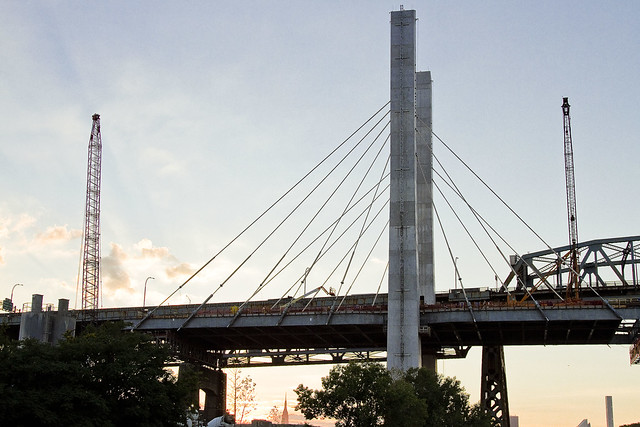
– photo by Mitch Waxman
That’s the Kosciuszcko Bridge replacement project pictured above, with the 1939 Robert Moses model bridge providing a backdrop to the under construction cable stay model. That’s the Brooklyn side, for the curious. This is a $1.2 billion replacement effort, “fast tracked” by Governor Cuomo, which is intended to replace what’s considered to be the most dangerous bridge in New York State – which happens to carry hundreds of thousands of vehicle trips a day as the Brooklyn Queens Expressway runs across its 2.1 mile long structure (along with its approaches).
– photo by Mitch Waxman
These shots were captured while onboard a NY Water Taxi hired for the evening by the Open House NY organization, and my colleague T. Willis Elkins and I were onboard to represent Newtown Creek Alliance and narrate to two sold out crowds. The second trip was heading back out from the Newtown Creek towards the East River just as sunset was occurring, and as always – Newtown Creek was and is a visual spectacular.
– photo by Mitch Waxman
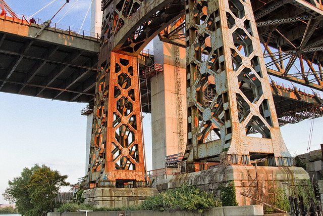
One has been trying to capture as many angles and shots as possible of the old Kosciuszcko Bridge for a couple of years now, simply because within the next 24-36 months it will have been eradicated from common memory.
This whole “Newtown Creek Historian” business isn’t just about revealing the past, it’s about leaving behind a visual record for those who haven’t been born yet about what the place looked like during its superfund and early 21st century transformational period.
– photo by Mitch Waxman
I’ve mentioned it before, but the plan which the State DOT has put forward is that once the eastern side of the new bridge is complete, they are going to reroute the BQE onto it. Then, they’re going to demolish the 1939 model, and in its footprint, build the western section of the new cable stay bridge. The great news about that is that there is going to be a pedestrian and bicycle path on the western side of the bridge.
One looks forward to walking the camera across, and getting aerial shots from up there.
– photo by Mitch Waxman
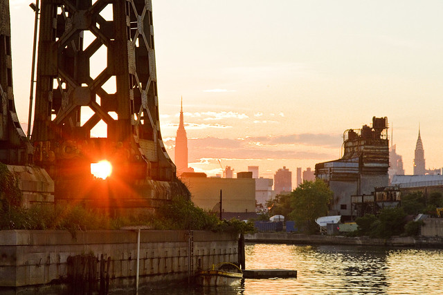
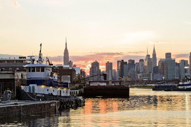
The burning thermonuclear eye of God itself was setting in the west as our NY Water Taxi navigated back towards the East River. That’s Blissville in Queens on the right hand side of the shot above, and the former location of not just Charles Pratt’s “Queens County Oil Works” but just about the very spot where the first large scale oil refinery in the United States – Abraham Gesner’s “North American Kerosene Gas Light Company” was founded.
– photo by Mitch Waxman
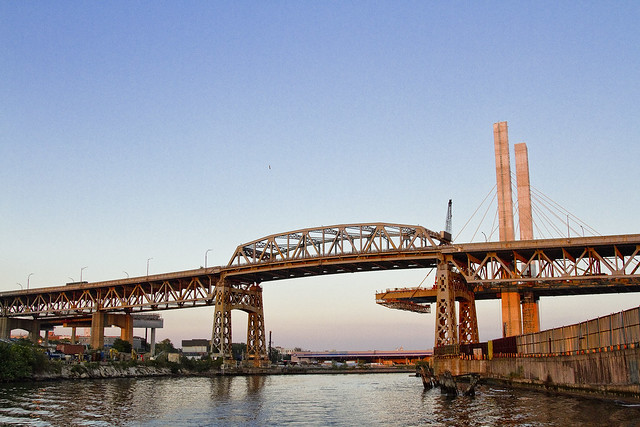
On the Brooklyn or Greenpoint side of Newtown Creek, the former home of the Standard Oil Company of New York and birthplace of what would be one day known as Mobil Oil is closest to the camera, which are now the ExxonMobil Greenpoint Remediation Project properties at 400 Kingsland Avenue.
Sitting on part of the former oil company properties in Greenpoint is the NYC DEP’s Newtown Creek Wastewater Treatment Plant, largest and newest of NYC’s 14 sewer plants.
– photo by Mitch Waxman
DUGABO – or Down Under the Greenpoint Avenue Bridge Onramp – is the heart of petroleum country on Newtown Creek. Greenpoint Avenue heads west into Brooklyn, terminating at the East River at Transmitter Park, whereas it continues into Queens and once having crossed Queens Blvd. – it transmogrifies into Roosevelt Avenue and continues all the way out into Flushing.
– photo by Mitch Waxman
From a maritime industrial point of view, the DUGABO area surrounding the Greenpoint Avenue Bridge is probably one of the busiest sections of Newtown Creek in the 21st century. SimsMetal and Allocco Recycling host regular tug and barge traffic, as does Metro fuel.
In the distance is the Pualski Bridge and the towers of the Shining City of Manhattan.
Upcoming Events and Tours
Saturday, August 6th, 2:00 p.m. – 4:00 p.m. –
Insalubrious Valley Walking Tour,
with NY Adventure Club. Click here for more details.
Sunday, August 14th, 11:00 p.m. – 1:00 p.m. –
Calvary Cemetery Walking Tour,
with Atlas Obscura. Click here for more details.
Sunday, August 21, 11:00 a.m. – 1:00 p.m. –
Poison Cauldron Walking Tour,
with Atlas Obscura. Click here for more details.
“follow” me on Twitter- @newtownpentacle
consequential consistencies
It does seem to be Creek Week, doesn’t it?

– photo by Mitch Waxman
In yesterday’s post, I told you about Deadman’s Curve in Maspeth, and we explored 57th avenue – the former “Creek Street.” The shot above looks eastwards towards Deadman’s Curve from the former Penny Bridge LIRR stop at Review Avenue. The water facing property is currently owned by John Quadrozzi Jr., who is a major land holder in the Red Hook and Gowanus areas. The property seems to be mainly used for storage and maintenance of heavy construction equipment these days.
As the name of the LIRR stop would imply, this is also the former location of Penny Bridge, which connected Brooklyn’s Meeker Avenue to Queens’s Review Avenue. Additionally, the Roman Catholic Church used to run a ferry service from Manhattan to Calvary Cemetery which docked nearby.

– photo by Mitch Waxman
Review Avenue, the stretch of it that runs along Calvary Cemetery, is where the first large scale petroleum refinery in the United States was founded – Abraham Gesner’s North American Kerosene Gas Light Company, which would become first the New York Kerosene Gas Light Company and then be acquired by Charles Pratt and Standard Oil and rechristened it as the Queens County Oil Company. Queens County Oil’s bulkheads are the ones that the Blissville Seep oozes petroleum into Newtown Creek from.
If you follow Review to the west, you’ll find the Greenpoint Avenue Bridge and a pair of roads which descend downhill on either side of it. They take you to, and from, Railroad Avenue.

– photo by Mitch Waxman
The eastern side of railroad avenue was formerly the home of the Van Iderstine company, who had their own rail spur down here which was populated with Van Iderstine’s distinctive black tank cars. As the name of the street – Railroad Avenue – would imply, it’s all about the tracks down here and on the western side of the Greenpoint Avenue Bridge you’ll find the LIRR’s Bliss Tower and Blissville Yard.
Welcome to DUGABO – Down Under the Greenpoint Avenue Bridge Onramp.

– photo by Mitch Waxman
Van Iderstine was a nightmare of a company, incidentally, or at least their occupation was. They were renderers, which means that pack animals, butcher scrap, rotten eggs, barrels of abattoir blood – even dead circus elephants – would be brought here to be broken down into components. What exited the factory was tallow.
Believe it or not, they weren’t the most ghastly operation along this stretch of the Lower Montauk tracks, just the smelliest. I can tell you stories about the yeast distilleries…

– photo by Mitch Waxman
Speaking of smelly, the modern occupation of the Blissville Yard is garbage. That’s the Waste Managemnt garbage train you see above, which is shipped around and about by the New York and Atlantic freight line. NY&A services two Waste Managemnt facilities on the Creek – one here in Blissville and the other in Brooklyn’s East Williamsburg along Newtown Creek’s English Kills tributary.
Something like 30-40% of all of NYC’s putrescent (black bag) waste comes to Newtown Creek to be processed and shipped off in green boxes such as the ones above.

– photo by Mitch Waxman
Railroad Avenue is one of those cul-de-sac streets along the Creek where there’s only one entrance or exit and which – if you get in trouble or hurt, it’s going to be damned difficult to explain to the 911 operator where you are. At the west end of the street is Sims Metal Management’s Newtown Creek dock, on the east you’ll find Waste Management’s Green Asphalt works, the same company’s putrescent waste transfer station, and the Marlyn industrial park which hosts such luminaries as LeNoble Lumber and A&L Cesspool. Personally, I’d call Sims for help, as they’re closer than any hospital and I know a couple of guys who work there.
This is, incidentally, some of what you’ll find located between Review Avenue, the Lower Montauk tracks, Railroad Avenue, and Newtown Creek.

– photo by Mitch Waxman
The Blissville Yard connects to the DB Cabin railroad bridge, which connects Blissville Yard to the Wheelspur and Hunters Point Yards in Hunters Point, and which crosses the Dutch Kills tributary of Newtown Creek. There’s also a connection to the M Cabin bridge which leads to the abandoned Montauk Cutoff tracks and Sunnyside Yards.
Freight traffic on Newtown Creek heads east into Maspeth and to the Fresh Pond Yard, eventually meeting the switch to the New York Connecting Railroad through Woodside and Astoria, which leads to the Hell Gate Bridge.

– photo by Mitch Waxman
Down towards the end of Railroad Avenue, one encountered this immolated automobile.
As mentioned multitudinous times, I cannot resist this sort of thing.

– photo by Mitch Waxman
This car wasn’t just burned up, it was thoroughly incinerated.

– photo by Mitch Waxman
That’s the sort of stuff you’ll see on Railroad Avenue, here in DUGABO, in the Blissville section of Queens, along the lugubrious Newtown Creek.
“follow” me on Twitter- @newtownpentacle
only the
Big doings on my beloved Newtown Creek, in today’s post.

– photo by Mitch Waxman
Word reached me that a barge had sunk on Newtown Creek last week, at the Allocco Recycling plant in Greenpoint, and despite suffering from a debilitating shoulder injury (Don’t worry, I seem to be on the mend) a humble narrator painfully packed up his kit and headed over to the tripartite intersection of North Henry Street and Kingsland Avenue at Newtown Creek.

– photo by Mitch Waxman
Allocco Recycling are in the metals and aggregates (or Fill Materials) industries. Metals are the usual thing – copper, aluminum, iron recycling and collection. Aggregates involves the seining and separation of rock, stone, sand, and gravel from construction and excavation materials. Allocco are good guys, in my book, as they ship their processed materials out of Greenpoint using barges rather than trucks. A single barge is the equivalent of 38 heavy trucks.

– photo by Mitch Waxman
Allocco has a large property that borders on one of Newtown Creek’s minor tributaries – the so called “Unnamed Canal.” Across the street is the Newtown Creek Wastewater Treatment Plant’s employee entrance, and down the block is a biofuel company called Metro Fuel. I’m prejudiced towards both entities, it should be pointed out. The DEP lies to me on a regular basis, so I don’t like them. Metro – whom I do like – on the other hand, was founded by my pal Paul Pullo. Paul is a friend and supporter of Newtown Creek Alliance whom I work with on a number of the NC committees like NCMC and the Newtown Creek CAG. NCA is also working with Allocco on our Living Dock project which is playing out on Unnamed Canal, as well as the “North Henry Street Project” which will be discussed in some detail at an NCA meeting next week.
All of my conflicts of interest are laid out in the paragraph above, except for one, which I’ll mention later.

– photo by Mitch Waxman
Showrunner Mike Allocco, it’s a family owned business after all, told me what happened (and allowed me on the property). It seemed that they were filling a barge with stone on a Friday night and closed shop. The half filled barge was about one third of the way submerged when they returned to work the next morning. His crew did everything they could to hoist and pump out the barge, but it continued to sink and by Saturday afternoon the barge was in the state you see in the shot above.
Allocco then contacted DonJon towing to salvage the thing, and DonJon brought in its heavy equipment. The large maritime crane – which is actually the second largest unit of its type in NY Harbor – is the Chesapeake 1000, and the smaller unit with the crawler crane attached is the Delaware Bay. There were a couple of tugs keeping them in position, but I was unable to identify which boats they were.

– photo by Mitch Waxman
The plan, which has already played out and been accomplished, closed Newtown Creek to maritime traffic for an interval. The DonJon crews fed a pair of cables under the sunken barge, lifted it out of the water, pumped out the water, and then moved it into a shallower section of the Allocco bulkhead for repairs. When these shots were gathered, the presumption was that the barge had a damaged hull.
That other conflict of interest mentioned above? As I was shooting these photos, I got a call from a reporter friend who was working for DNAinfo that wanted to buy a shot from me. That shot, and my buddy’s reportage, can be observed in this post at DNAinfo. As the article discusses, the barge had settled down over the Buckeye Pipeline, and luckily for all of us – the fuel delivery infrastructure wasn’t damaged. This was due to the barge settling down onto the so called “Black Mayonnaise” sediments which sit 15-20 thick on Newtown Creek. The quote from DEC’s Randy Austin presented in the DNA piece is ““That’s probably the first time in the history of the Newtown Creek when that sludge bank served as an environmental benefit.”

– photo by Mitch Waxman
For a maritime industrial geek like your humble narrator, seeing the Chesapeake 1000 was a real treat. DonJon Towing hosts a page listing all of the technical specifications that this 1972 vintage 2,484 Gross Tonnage crane entails. The “1000” part of its name comes from its lifting capacity, but it used to be known as the Sun 800 before DonJon got it. The Sun 800 was damaged in a storm, and during the repair process it was upgraded and outfitted with the 1,000 ton boom it currently sports. The hard hat guys I chatted with on the shoreline at Allocco related the cranes history to me as we watched the operation.
Now, this is where the interesting bit comes in.

– photo by Mitch Waxman
It seems that the Sun 800/Chesapeake 1000 was originally built by the Howard Hughes corporation to facilitate the Glomar Explorer project. Glomar Explorer was a giant ship built in the early 70’s which the Hughes people told the world was going to be used for the harvesting of ocean floor minerals and specifically manganese nodules.
That was a cover story, however, for the true mission of the thing, which was to recover a Soviet submarine which had sunk some three miles down on the floor of the Pacific Ocean for the CIA. The project was called “Project Azorian.” The Chesapeake 1000 is officially an artifact of the height of the Cold War, like the Saturn V rocket.
It continually amazes me, the sort of things that Newtown Creek leads to.

– photo by Mitch Waxman
The other DonJon rig on the job was Delaware Bay, which is a clam shell dredge vessel. It’s got 1,250 square feet of deck space and was built in 2006. It’s 225 feet long and 54 feet wide, and 1,205 gross tonnage.

– photo by Mitch Waxman
The barge itself is unremarkable, other than the fact that it’s submerged. It’s a dry bulk type, and is essentially a giant floating bucket.

– photo by Mitch Waxman
As mentioned above, the crews from DonJon were executing a plan in which a couple of heavy cables would be run under the sunken barge, at which point the Chesapeake 1000 would lift the thing up and out of the Creek and then pump out the water. To this end, there was a dive team operating.

– photo by Mitch Waxman
One cannot imagine the horrors of diving into the turbid waters of Newtown Creek, nor the safety precautions that a professional diver would need to undertake in pursuance of the act. I’ve had the pleasure of chatting with members of this profession who operate in NY Harbor, and they tell me that it’s actually a blind business.

– photo by Mitch Waxman
Visibility in the waters of NYC is a couple of feet under best case circumstance, but in the East River and its tributaries, you often can’t see your hand six inches from your face mask. They do a lot of their job by feeling around, and relying on their training.
One fellow kept on bobbing up around the cables which were being fed under the sunken barge.

– photo by Mitch Waxman
So, that’s the story about the time in February of 2016 that a barge sunk at a recycling company called Allocco in Greenpoint, along the lugubrious Newtown Creek.
“follow” me on Twitter- @newtownpentacle
of them
I cannot understand why others do not find these things quite as thrilling as I do.

– photo by Mitch Waxman
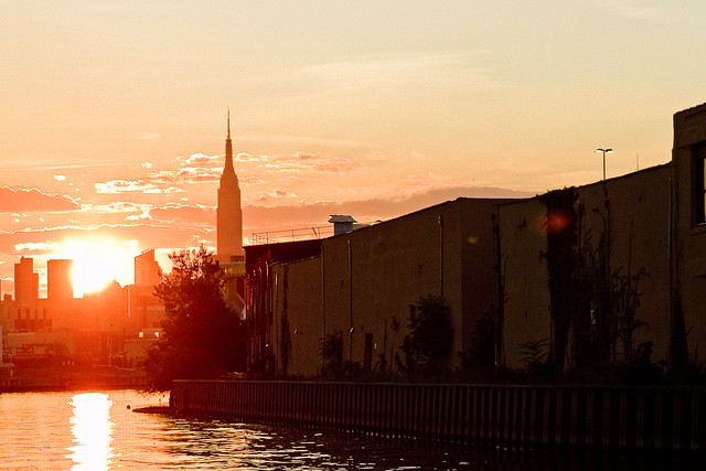
On one of my constitutionals, a humble narrator found himself at the veritable edge of Queens, heading in a southerly direction through Blissville on my way to “the Pernt.” Hoary Greenpoint can be accessed from Queens via just a few easily defensible littoral spots, one of them being an eponymous path called “Greenpoint Avenue” and the bridge which is named for it.
It’s a double bascule draw bridge which spans my beloved Newtown Creek, and I refer to the area surrounding it in both Brooklyn and Queens as “DUGABO” which is short for “Down Under the Greenpoint Avenue Bridge Onramp.”

– photo by Mitch Waxman
Off in the distance to the east, another one of these Thermopylae like passages is visible, the Kosciuszko Bridge.
Should hostilities between Brooklyn and Queens ever break out, it is certain that their respective militaries will make every effort to take and control these passes. Ultimately, you’d want absolute command and control over Pulaski, Kosciuszko, and Greenpoint Avenue Bridges, although sentries and artillery units would no doubt be deployed all along the Newtown Creek to guard against an amphibious invasion. The crumbling bulkheads and industrial fence lines would no doubt make for a daunting landing, and the Queens faction would have a de facto advantage in the conflict due to their ability to deploy artillery on LIRR flatbed cars.

– photo by Mitch Waxman
The Brooklyn side would be devastated by the first wave of a rail based artillery attack, given the massive presence of oil storage tanks on the southern shoreline. The sewer plant would be an easily targeted site, but vast reserves of Kings County loyalist troops can be found to the South and could easily be brought to the front by the G line. I’m sure there would be a fierce battle in the G tunnel underneath the Vernon/Manhattan avenue area, fought by locally raised units. Lentol’s Leathernecks, and Nolan’s Raiders, would fortify on either side of the tube, with setups reminiscent of WW1 trenches. It wouldn’t be long before both sides resorted to the usage of wonder weapons like poison gas, supplies of which are easily attainable on either side of the fabled Newtown Creek.
Queens would likely attempt the use of the 7 line to ferry in reinforcement troops like Van Bramer’s Sunnyside Battalion and Dromm’s Sikh and Gurkha Jackson Heights Commandos and the terrifying forces of the Meng Men from Flushing and Elmhurst, while Brooklyn would likely use the L line to bring in Reynoso’s Roughnecks, Levin’s Loppers, and Reyna’s Reapers from points east and south. Further to the east – where the borders of Brooklyn and Queens are not aqueous but rather terrestrial in nature – Dilan’s Death Dealers, Liz Crowley’s Maquis Freedmen, and Joe Crowley’s Fenians (backed up on their flank by Grodenchik’s Garroters, Vallone’s Vanquishers, and Katz’s Killers) would all be engaged in a Stalingrad like guerrilla struggle over Maspeth, Ridgewood, and Fresh Pond.
Media attention on the conflict would be of course be focused on LIC and Greenpoint, since you could see that from Manhattan’s east side.
Irregular sappers, freelancers like the Gambinos and Latin Kings, would no doubt be utilized by both sides in this Blood War of the Boroughs.

– photo by Mitch Waxman
Whilst musing about the idea of internecine and interborough warfare, I suddenly realized that traffic had stopped flowing on the Greenpoint Avenue Bridge. Worrying that the dark day had arrived at last when the border of Brooklyn and Queens would be marked by fire and death, it suddenly became apparent that the DOT was preparing to open the bridge to allow a maritime transit.
Whooopppeeee!!!

– photo by Mitch Waxman
To all of those stopped in traffic, it must have appeared odd, seeing some despoiled creature In a filthy black raincoat jumping up and down while squealing with joy and waving a camera around.
A minor inconvenience experienced by others is often a moment of joy for me.
I got busy with the camera, and ran out onto the non movable part of the roadway, which is normally quite a chancey thing to do on the highly travelled span over Newtown Creek, as you’d get squished by a truck.

– photo by Mitch Waxman
God help me, but I just love watching a draw bridge at work. Also, check out those bike lanes. I encouraged a bicyclist to make a try for it, telling him he could easily jump the gap if he got enough headway speed. He ignored me and played with his phone instead.
Some people, I tell you, have no sense of adventure.

– photo by Mitch Waxman
The apogee of the bridge roadway’s open posture was attained shortly, and it rose in monolithic fashion. This is likely the position that the Bridge would be fixed into should hostilities between Brooklyn and Queens break out, which is offered as a strategic and or tactical note to the future combatants.

– photo by Mitch Waxman
In my incessant research of all things Newtown Creek, an eventuality in which the Creek would have become militarized was actually set down by the War Department of the United States, during the World Wars period of the early 20th century.
Naval Destroyers (sometimes the presence of a battleship is discussed as well) were set to be stationed along the Newtown Creek (as well as the East and Hudson rivers) and its tributaries to defend the Petroleum and Industrial bases along its shorelines from air or naval attack. The anticipated pathway which a German invasion fleet would have followed involved a passage through Jamaica Bay and the Narrows in pursuance of invading Manhattan at the Battery and Brooklyn via Bay Ridge. The naval guns on Newtown Creek would have been trained on the Narrows, shooting artillery in a parabola over all of Brooklyn and bombarding enemy vessels on the waterway. The defensive plan was to create a “death zone” between and supported by Forts Totten (Staten Island) and Hamilton (Bay Ridge). Governors Island was also meant to play a role in the deployment of long range defenses and weaponry.
I know, sounds silly to we children of the atom, but this was an actual military plan. It’s part of the reason why the Kosciuszko and Long Island Expressway over Dutch Kills were built as high as they are, to allow the smoke stacks of ocean going Naval Ships purchase. The East River Bridge heights were also built with the Brooklyn Navy Yard and the presence of Capital Ships in NY Harbor during times of war in mind. It’s one of those “alt history” scenarios which leads to a fascinating thought experiment – a Kriegsmarine and Wehrmacht invasion of New York Harbor (their ACTUAL plans, btw, would have included the setup of a German base of operations at Sandy Hook). Just to reiterate – the Germans were ACTUALLY and ACTIVELY planning for this.

– photo by Mitch Waxman
Of course, an invasion of the United States would have been contingent on the Germans not being involved in two major European land conflicts simultaneously, and Germany being at peace with the UK and the Royal Navy. The invasion of NY Harbor would have represented about a third of the German assault, with other units landing at Cape Cod in Massachussets and in Virginia. A simultaneous landing of troops from the Japanese Empire would have occurred in Seattle and in San Diego.
Lost in my alt history thoughts, I suddenly realized that I didn’t know which vessel the bridge had opened for, and a quick dog trot to the fences of the eastern side of the bridge was enacted.

– photo by Mitch Waxman
The Mary H tug was towing a fuel barge, no doubt headed some three and change miles back from the East River to the Bayside Fuel depot found nearby another one of the flash points in a Borough on Borough war – the Metropolitan Avenue Bridge. Both Grand Street and Metropolitan Avenue Bridges span narrow passes on the Creek, where small arms fire and snipers would be easily able to command and control access between the two warring sides.
What would be the cause of a war between the two boroughs? Good question, lords and ladies.

– photo by Mitch Waxman
My bet is that it would be a trade dispute, with Brooklyn enacting a restrictive tariff on all things artisinal and organic.
“follow” me on Twitter- @newtownpentacle


