Archive for the ‘Pickman’ Category
was invariable
DUPBO, in LIC.

– photo by Mitch Waxman
Down Under the Pulaski Bridge Onramp, or DUPBO in Long Island City, is pictured above. Recent endeavor found one wandering around this area just after sunset about a week ago, and one decided to get busy with the camera.
The Pulaski Bridge was built by the NYC DOT as a replacement to the older Vernon Avenue Bridge which was found about a block or so to the west. The old bridge connected LIC’s Vernon Blvd. with Greenpoint’s Manhattan Avenue, and there was a streetcar or trolley service which connected the two shorelines of Newtown Creek. The former Orchard Street (bet Greenpoint Avenue and the Creek) in Brooklyn was renamed “Manhattan Avenue” about 1915 (I believe, and that’s from memory so don’t trust me on that), as the LIC side offered proximity to the brand new IRT Flushing line (the 7) subway. The trolley stop in LIC, where the trolley came to rest, is the NYC Parks Dept.’s “Vernon Mall” today. Back then, you named streets for where they were going, today you give parks meaningless names which obfuscate the past, but that’s why Greenpoint’s Orchard Street is Manhattan Avenue today.

– photo by Mitch Waxman
The derelict shoreline of LIC in DUPBO between the bridge and the Vernon street end is occupied and exploited by a colony of squatter boats these days. A hundred years ago, you would have been looking at a fleet of small tugs owned by the Newtown Creek Towing Company, whose HQ was found next door to an Ulmer Brewery Tap room on Vernon beneath the old bridge. Back then, modern day 54th and 53rd avenues were part of the LIRR Pigeon Street rail yard, which adjoined the Hunters Point Yard on the north and had tracks feeding into the Jack Frost sugar factory on the East River. The squatter boats are all blurry looking because they were rolling around on the wake of a tugboat and barge combo which had just navigated past.
The large structure on the Greenpoint side is the former Chelsea Fiber and Jute Mill at the end of Manhattan Avenue, which is known to modernity as the Greenpoint Manufacturing and Design Center – or GMDC.

– photo by Mitch Waxman
As part of the post WW2 citywide expansion of arterial roadways, drawn up by and overseen by Robert Moses, the Pulaski Bridge was designed as a high draught drawbridge which would span the Newtown Creek and magnify the amount of traffic flow between the two boroughs. Both 11th street in LIC and what would come to be called McGuinness Blvd. in Greenpoint were widened to accommodate this extra traffic. From DUPBO, you may notice that the Pulaski sports what appears to be an unfinished traffic ramp which arcs off of the eastern or Queens bound side. I’ve never been able to confirm it definitively, but the general presumption I hold is that Moses and his crew once intended to connect the Pulaski’s “flow” with the Long Island Expressway.
A bascule drawbridge of paralell counterweight design and driven by electrical motors, construction of the Pulaski Bridge was overseen by the New York City Commissioner of Public Works – Frederick Zurmuhlen – and the general contractor employed in building it was the Horn Construction Company, with steel and expertise supplied by Bethlehem Steel. It opened in September of 1954 at a cost of $9,664,446.25 – and a reconstruction of the bridge in 1994 cost $40 million. It carries five lanes of vehicular traffic, as well as dedicated (and now separated) bicycle and pedestrian lanes, and it’s a primary crossing between north Brooklyn and western Queens.

– photo by Mitch Waxman
Looking eastwards along Newtown Creek, a tug and barge passed through this thirty second exposure, causing a colorful light show to appear on my camera’s sensor. I’m fascinated by this sort of time capture, incidentally. The normal procedure for photographically capturing the passage of time is to record video, of course, or even to fire off a burst of shots. One of the things that’s emerged during all of this night photo long exposure work I’ve been doing for awhile now is that I can reveal traffic patterns, the passage of normally invisible critters in the water, even the invisible currents of air if I set the camera up correctly. You can see the pathways of fish in the water, rendered out by the reflective streaks coming off of their scales, for instance.
If I was sure that I wouldn’t blow up Brooklyn or Queens (or the Buckeye Pipeline), I’d love to throw a block of magnesium into the water and photograph it as it sank and burned – illuminating the bed of the creek. Who can guess, all there is, that might be swimming around down there? Subaqueous features, sunken boats, Jimmy Hoffa?

– photo by Mitch Waxman
That’s the staircase leading up to the LIC side of the pedestrian walkway atop the Pulaski Bridge. One advises all not to hold onto the side rails unless they have to, as the Pulaski’s rafters are full of pigeons and the entire bridge is covered in layers of guano.
The lady on the bicycle annoyed me, incidentally. Seeing me standing there with a camera and tripod setup, she first stopped her bike literally two feet away and in front of me for an interval of playing with her phone. I gently asked “excuse me, miss, can I ask you to just move forward two feet so as you’re not in my shot?” to which she silently shot me back a look of annoyance and then rolled further into the shot and right in front of the stairs. So enthralled with her glowing piece of telecommunicative glass that bodily movements all but ceased, she appears in the shot above as a semi transparent statue. There’s a metaphor in there somewhere, but I wouldn’t want to trigger the “waiting to be offended” or “overly sensitive” millennial crowd.
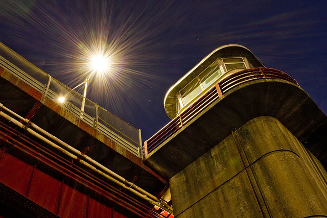
– photo by Mitch Waxman
Looking upwards at the control tower of the Pulaski Bridge from the waters edge, which is what you’re seeing. That’s where the various knobs, dials, buttons, and levers that open and close the thing are found.
These shots were gathered using my “minimal” carry setup (2 light lenses, cable release, air blower, couple of lens cloths, and that Ultrapod camera support gizmo), and I used the cheapo Canon “pancake” 24mm lens which I’ve mentioned in the past for all of them. For a variety of reasons, it doesn’t always work for me to grab the whole kit and kaboodle on my way out of HQ, and I’m also trying to carry a bit less around with me than I usually do at the moment in general. Also, not having zoom lenses and being “mission specific” forces me to think more about the “where” of my shots and there’s also the whole “be intentional” thing.
Also, lest I forget, “Pulaski Bridge” – Casimir Pulaski was a Polish military officer who joined General Washington’s Continental Army of the 13 colonies in order to assist in their war of rebellion against the Hanoverian Throne of England during the Revolutionary War. Google him, interesting person, and a Polish National Hero.
I have to don my monkey suit tonight and head off to the City for a party with the fancy folks on the Hudson side of things. I’ll be carrying the minimum kit again, so let’s see what I can get.
“follow” me on Twitter- @newtownpentacle
Buy a book!
“In the Shadows at Newtown Creek,” an 88 page softcover 8.5×11 magazine format photo book by Mitch Waxman, is now on sale at blurb.com for $30.
uncanny noise
I got to ride on a New York and Atlantic Freight Train!

– photo by Mitch Waxman
Pictured above is the New York and Atlantic’s newest ride – Engine 400. Before I say anything else, I want to acknowledge my pal David Silver and his encyclopedic knowledge of all things rail for pointing me in the right direction on the original make and model of this particular locomotive engine. Originally built in 1966 for the B&O railroad, this model GP40 locomotive’s original configuration offered some 3,000 HP.
NY&A has recently (2018) had the thing rebuilt at Knoxville Locomotive Works to bring it in line with modern day Tier 4 emissions standards. It lost 700 HP in the conversion, it seems, but NY&A operates on fairly level terrain (by rail standards) in NYC and Nassau and Suffolk Counties. NY&A are a private company contracted by the Long Island Railroad to handle their freight duties, as a note.
Also as a note, I’ve actually photographed this unit before, at night in Maspeth at the Haberman tracks in March of 2019. Check that out here.
from wikipedia
The GP40 is a 4-axle diesel-electric road-switcher locomotive built by General Motors, Electro-Motive Division between November 1965 and December 1971. It has an EMD 645E3 16-cylinder engine generating 3,000 hp (2,240 kW).

– photo by Mitch Waxman
The ride itself was offered by NY&A, the Waste Management Company, and the North Brooklyn Chamber of Commerce. A small group of invitees assembled at Waste Management’s Brooklyn waste transfer station on Varick Street, and there were three opportunities to ride on the thing along the Bushwick Branch tracks leading through East Williamsburg into Ridgewood and then Maspeth. I rode it twice, sitting out the middle trip so I could get shots of the thing coming and going.
This was actually pretty exciting for me, since my oft repeated “I don’t trespass” stance has often found a humble narrator staring wistfully at some trackway which I was dying to explore. Today’s post is proof of my pudding that eventually I will get to go where I want, in the company of the people who own the thing, and that I will be able to publish the photos publicly. A number of the officers of NY&A were onboard, notably the NY&A’s president James Bonner.

– photo by Mitch Waxman
Hampering the efficiency of the line are the multiple “at grade” street crossings which the route follows. There are no signal arms or even flashing lights and bells to warn motorists or pedestrians or even – god forbid… bicyclists – that the train is about to cross the street along this section of the route. Procedure dictates that the conductor (apparently that’s what you call the guy, even though there’s usually no passengers) gets off the train and walks ahead of the engine, stopping approaching traffic the NYC way – standing in the middle of the street and waving his arms around.
James Bonner told me that this situation is something that the company is trying to fix with some haste, but for now the train moves through this section of the Creeklands at the limited speed which a conductor can walk.

– photo by Mitch Waxman
The train carried us roughly a mile into Queens and then reversed back towards the Varick Street location. A humble narrator got quite busy with the camera on this trip. Most of what I shot were pretty boring photos, which were recorded in a simple documentarian manner depicting and detailing the otherwise forbidden rail tracks. During the excursion, I was allowed to walk around on the engine’s catwalks. There were a couple of other photographers along for the trip, as a note. Assemblyman Joe Lentol of Greenpoint was onboard as well, along with other notables from Brooklyn. At one point, the Commissioner of the NYC Dept. of Sanitation showed up and she made a speech.
The notables were riding in a little caboose at the back of the train set. I rode in the caboose on the last ride of the day, but during the first trip I was on the locomotive section. In between the two, there was a “slug,” which I’m told acts as a purely mechanical augment to the locomotive engine providing additional tractive effort assistance and extra braking capability.

– photo by Mitch Waxman
The engineer driving the train was a pretty good humored fellow, but I never did catch his name. He was seated at a console offering multiple digital indicators and gauges. I don’t have room for what the console looked like in this post, but if you want to get an idea of it – check out this photo of the setup over at flickr.
Of course I had to be a jackass at least once during the trip, and while standing on the engine’s catwalk at a street grade crossing in Maspeth, I spotted an attractive woman waiting for the train to pass. I shouted out “hey, what do you think of my ride?” to her, and she smiled and then winked her eye at me. It was probably just the sun, or dust, or a seizure, but I’m holding on to it being a wink – thank you very much. I’ve still got it.

– photo by Mitch Waxman
The train returned to the Waste Management facility at Varick Street, where bags of NY&A shwag were waiting for us. I got a neat baseball hat with a NY&A logo on it, and a pen with a logo too. Just behind the train, you’ll notice a fence line with some green material affixed to it. Right on the other side of that bridge is the loathsome terminus of the Newtown Creek’s English Kills tributary, some 3.8 miles from the East River. The water is crossed by, and the Bushwick Branch tracks are mounted upon, the Montrose Avenue Rail Bridge, which is roughly 3.7 miles from the East River.
I don’t come back here very often – remember that “I don’t trespass” thing? Also, this is a pretty far walk from Astoria. Saying that, check English Kills and the Montrose Avenue Bridge out at night in this 2019 post, during the day in this 2017 one, and for more on the LIRR’s Bushwick Branch tracks click through and all the way back to a simpler time in this 2012 post.
What a week I had!
“follow” me on Twitter- @newtownpentacle
Buy a book!
“In the Shadows at Newtown Creek,” an 88 page softcover 8.5×11 magazine format photo book by Mitch Waxman, is now on sale at blurb.com for $30.
pillars grouped
Ugghhh.. Manhattan.

– photo by Mitch Waxman
After the boat trip with the United States Army Corps of Engineers ended when we docked at a ferry terminal in Lower Manhattan, I suddenly found myself thrust into the middle of a dystopian nightmare. One had to get home to Astoria to allow Zuzu the dog an opportunity to relive herself of bodily waste, and prepare myself for what turned out to be a highly annoying Community Board 1 Transportation Committee meeting. We were discussing ferries and bike lanes, so of course it got to the boiling point pretty quickly. Passions run deep amongst the bicycle fanatics.
Busy day for a humble narrator, huh?
It was hot when we arrived back in Manhattan, which is appropriate for an urban hellscape, I guess. Check out that little visible bit of the sky which hasn’t been appropriated to glass towers visible in the shot above.
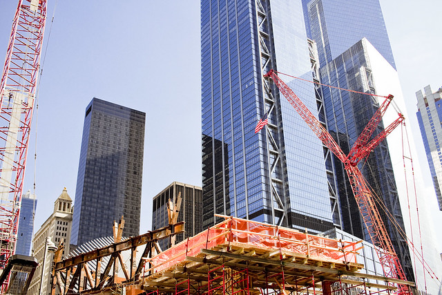
– photo by Mitch Waxman
At the site of National Tragedy, more and more reconstruction is going on. Eighteen years, I have to keep on reminding myself. Eighteen years.
I made my way into the rebuilt subway station at World Trade Center, which is now found under a shopping mall which is populated by shops where there’s naught an ordinary person such as myself could afford, and then boarded an E line train to get out of dodge and back to Western Queens where I belong.

– photo by Mitch Waxman
A number of people have commented to me over the years that my demeanor actually alters for the better upon passing over or under the border between Manhattan and Queens. At Queens Plaza, with its rotting concrete and dripping masonry, one transferred to the M line which took me the rest of the way back to blessed Astoria. Zuzu the dog seemed quite amused when I opened the door to HQ, but then promptly fell asleep.
Tomorrow – the other really cool thing I got to do last week will be discussed. It was an actual adventure!
“follow” me on Twitter- @newtownpentacle
Buy a book!
“In the Shadows at Newtown Creek,” an 88 page softcover 8.5×11 magazine format photo book by Mitch Waxman, is now on sale at blurb.com for $30.
away ahead
More from the Circumnavigation of Staten Island with the USACE.

– photo by Mitch Waxman
As described in prior posts, one was invited to travel with the United States Army Corps of Engineers on their annual harbor inspection onboard the MCV Hayward last week. The first part of the journey left lower Manhattan and then travelled along the eastern coast of the island, which was ravaged by Hurricane Sandy back in 2012. The USACE commander – Col. Thomas Asbery – and his crew described some of their ongoing, and a few of the upcoming, projects which they are working on that are designed to vouchsafe the area in the era of climate change. The Hayward then took a northern turn onto the Arthur Kill, a busy maritime industrial tidal strait connecting Newark Bay and the Kill Van Kull with Raritan Bay to the south.
Pictured above is the Dylan Cooper, a Reinauer company owned tugboat. Reinauer, like all towing companies in NY Harbor, paint their boats in a particular fashion. The “colorway” allows for rapid identification of a vessel while it’s under way, so you can call out on the radio to it as “Reinauer tug” long before you see the IMO identification number or vessel name painted on the hull. This practice predates modern day radio transponders, which make it somewhat unnecessary, and provides for a bit of colorful panache on the water.

– photo by Mitch Waxman
The western shoreline of the Arthur Kill is in the state of New Jersey (Union and Middlesex Counties), and the eastern is in NYC’s Staten Island. Arthur Kill is about ten miles long, and has also been referred to historically as the Staten Island Sound. The name “Arthur Kill” is an anglicization of the old Dutch “Achter Kill” which translates as “back channel.” Arthur Kill, geologically speaking, is defined as an “abandoned river channel,” which was carved out of the surrounding land by an ancestral pathway of the Hudson River. The New Jersey side is colloquially referred to as “the Chemical Coast.” The expensively maintained depth of the water here is between 35 and 37 feet, and the channel is an average of approximately six hundred feet wide.
The Staten Island side is largely post industrial, with a few notable exceptions. Arthur Kill is crossed by three bridges – The Outerbridge Crossing, the recently replaced Goethals, and the Arthur Kill Vertical Lift Bridge. The first two are vehicle bridges, and the latter is for railroad traffic.

– photo by Mitch Waxman
That’s the New York Container Terminal (aka Howland Hook Marine Terminal) pictured above, on the Staten Island side of the Arthur Kill. Currently being upgraded and massively expanded due to the acquisition of Proctor and Gamble’s Port Ivory, the NYCT was originally built by American Export Lines, but NYC bought the facility in 1973 and it’s leased by the City to the Port Authority. There’s a rail connection just upland from it, which allows for the transport of containers along the former North Shore railroad route originally built and operated by the Vanderbilt owned B&O railroad.
They handle some commercial cargo here, and there’s a customs facility, as well as deep freeze and refrigeration warehouses. Most of the tonnage moving through NYCT these days though are garbage containers, which are loaded from rail cars onto barges for transport off of Staten Island.

– photo by Mitch Waxman
MCV Hayward outpaced Dylan Cooper after the NYCT, and we proceeded to cross the Shooters Island reach and head towards Newark Bay. A “reach” in navigational terms is how far you can travel on a single compass heading before heading to adjust your course, if you’re curious. Arthur Kill and Kill Van Kull intersect with Newark Bay at the Shooters Island Reach. To the south, some ten miles behind us, Arthur Kill meets Raritan Bay. About a mile south of Raritan Bay is the Atlantic Ocean. Newark Bay itself is formed by the intersection of the Hackensack and Passaic Rivers.
Primeval Newark Bay was called the Newark Meadows, before the 1910 efforts by the City of Newark to carve a shipping channel through the wetlands. The Port Authority of New York and New Jersey was created in 1921, and their first big project was the widening and deepening of the bay for maritime industrial purposes.

– photo by Mitch Waxman
In 1927, the PANYNJ used some of the dredge tailings to fill in upland wetlands and the City of Newark took advantage of the new land to create an airport. PANYNJ took over the airport and maritime port in 1948. In 1958, a project at the Bound Brook (formerly defining the border between Elizabeth and Newark) produced enough dredge tailings for the authority to create 90 square acres of new land and the first modern container terminal in NY Harbor was established. The terminal footprint has since expanded to 350 square acres.
The age of containerized global shipping actually got its start here in 1958 when the first container ship – the Ideal-X, a converted US Navy cargo ship – was launched from Port Newark. The cargo container concept was innovated by trucking company executive Malcolm McLean and an engineer named Keith Tattinger. In 1963, the Sea Land Terminal was established at Port Elizabeth Newark, and the rest – as they say – is history.

– photo by Mitch Waxman
On our way back to dock in Manhattan, just east of the St. George Terminal of the Staten Island Ferry, another United States Army Corps of Engineers vessel and its crew were hard at work. That’s the MCV Gelbart, and the crew members who are pictured standing on that rig tied up “on the hip” of the tug were busy removing flotsam and jetsam from the water. They were handling the “small stuff,” which Col. Asbery described as being mainly plastics – bottles, carrier bags, and the like. That’s what happens when you litter, lords and ladies, it ultimately ends up in the water.
Tomorrow – something completely different, and Friday’s post will ultimately be all about garbage again. You won’t believe what I got to do.
“follow” me on Twitter- @newtownpentacle
Buy a book!
“In the Shadows at Newtown Creek,” an 88 page softcover 8.5×11 magazine format photo book by Mitch Waxman, is now on sale at blurb.com for $30.
magnitude of
Arthur Kill with the USACE, in todays post.

– photo by Mitch Waxman
As described yesterday, I was invited to join with about a hundred other water facing activists and government officials aboard the MCV Hayward for the United States Army Corps of Engineers annual inspection of NY Harbor. This time around, the USACE wanted to discuss their projects and initiatives playing out on Staten Island and at the Port facilities in Newark Bay. After navigating beneath the Verrazano Bridge, the Hayward entered the Arthur Kill – a roughly ten mile long tidal strait which forms Staten Island’s border with New Jersey.
That’s the NJ side tower of the Outerbridge Crossing pictured above, a 1928 suspension cantilever bridge (thx Dan S) operated by the Port Authority. It connects NY route 440 with NJ route 440, offers a 143 foot clearance over the water, and with its approaches the Outerbridge Crossing is just over three miles long. It’s named for “Gene” Eugenius Outerbridge, who was the first chairman of the Port Authority of New York and New Jersey.

– photo by Mitch Waxman
For somebody with my interests, Arthur Kill is a wonderland of maritime industrial splendors. Given that it’s fairly difficult to get here by boat, given the distance and time/fuel equation, it’s a rare treat for me to be waving the camera around while moving north along it. Also compounding the treat aspect is the time of year (early autumn light in NY Harbor is at the perfect relative angle) and of course there was also the company. While I was shooting this, I was joking around with members of the EPA team from the Newtown Creek Superfund, who are normally quite staid and maintain a “professional” demeanor in our usual encounters. I also got to hang out with the Deputy Commissioner of the DEP, a few people I know from the City Planning arm of NYC Government, and a gaggle of Graduate students and their Professors who are studying various aspects of the harbor. Good times.

– photo by Mitch Waxman
To my eye, that’s a former coaling station on the New Jersey side of Arthur Kill. I could be wrong, but I don’t want to inquire too deeply as it’s important to me that there’s still things out there in the Harbor that I don’t know everything about. The New Jersey side of Arthur Kill is often called “the Chemical Coast,” due to a rail line just upland called the “Conrail Chemical Coast Line” which is part of the PANYNJ expressrail system at Port Elizabeth Newark.
The Chemical Coast moniker first appeared in the late 19th century, when the colorants and dyes industry began to base themselves in this section of New Jersey. These industrialists took advantage of the abundance of manufactured gas byproducts being produced around NY Harbor. The red in the American flag, and the blue, are after products of gas manufacturing. Those businesses got forced out when Standard Oil took over the NJ side coastline, and the Standard Oil Company of New Jersey was established. SOCONJ eventually changed its name to ESSO and later to EXXON.

– photo by Mitch Waxman
There are numerous tributaries and secondary waterways feeding into Arthur Kill – on the New Jersey side you’ve got the Elizabeth, Rahway, Passaic, and Hackensack Rivers (I met citizen activist counterparts for Newtown Creek Alliance from each onboard) as well as the Morse’s and Piles Creek. On Staten Island, you’ve got Lemon, Old Place, Sawmill, and Bridge creeks. Also on Staten Island, you’ve got the infamous Fresh Kills.
That’s the Dann Towing tug Ruby M navigating past the largest man made object on the planet, which is in Staten Island and which the Fresh Kill still flows through. Draining most of the western half of the island, Fresh Kill was designated as NYC’s primary garbage dump and landfill by Robert Moses back in 1947. Between 1948 and 2001, 20 barges a day of garbage – some 650 tons per day – was layered into the pile at the Fresh Kills landfill. NYC Parks took it over in 2006, and converted the now covered mound into a park. Fresh Kills instantly increased NYC parkland by one third.

– photo by Mitch Waxman
One of the future projects which USACE discussed onboard was doing something about the old Witte Ship’s graveyard just north of Fresh Kills. A maritime scrap yard established in 1930, which is a shadow of its former self, the Witte graveyard is nowadays owned by the DonJon towing company. The Army Corps folks discussed their concerns about slicks of unknown composition they’ve observed coming from the wrecks, and the nuances of what would essentially be an excavation job to clean up and remediate the area.
Cotter Dams were mentioned, as well as an extremely large number of dollars.

– photo by Mitch Waxman
Moving northwards along Arthur Kill, we slotted into the channel under the brand new and recently opened Goethals Bridge replacement. The original Goethals was built at the same time as Outerbridge Crossing, 1928. Named for the first supervising engineer of the Port Authority – Gen. George Washington Goethals (who also happened to be the construction supervisor of the Panama Canal) – the original bridge offered two lanes in each direction. The new model sports three traffic lanes, is meant to have a pedestrian and bicycle lane, and the engineers built the thing with the capability of eventually carrying a mass transit light rail line, should the need arise sometime in the next century.
More tomorrow.
“follow” me on Twitter- @newtownpentacle
Buy a book!
“In the Shadows at Newtown Creek,” an 88 page softcover 8.5×11 magazine format photo book by Mitch Waxman, is now on sale at blurb.com for $30.


