Archive for the ‘Pickman’ Category
professional duty
Friggin Wednesdays…

– photo by Mitch Waxman
One suspects that this will be a seldom read post, given that the vast majority of New Yorkers will be going somewhere else today. I plan on staying in Astoria, just to defend the neighborhood against burglars and sneak thiefs.
I also plan on walking out into the concrete devastations of Newtown Creek a few times, in pursuance of more nocturnal shots like the ones in today’s post.

– photo by Mitch Waxman
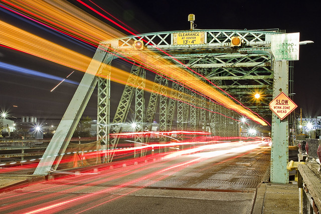
The City has been replacing its street light heads with cold colored LED luminaires in recent years, which are meant to provide brighter and more directed light onto roadways. The State is still using the old school sodium lights which produce a warm yellow-orange light.
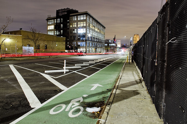
A humble narrator is often fascinated by the spots where these two different colors of artificial light mix, as in the case of the shots above which is in DULIE – Down Under the Long Island Expressway – here in LIC.

– photo by Mitch Waxman
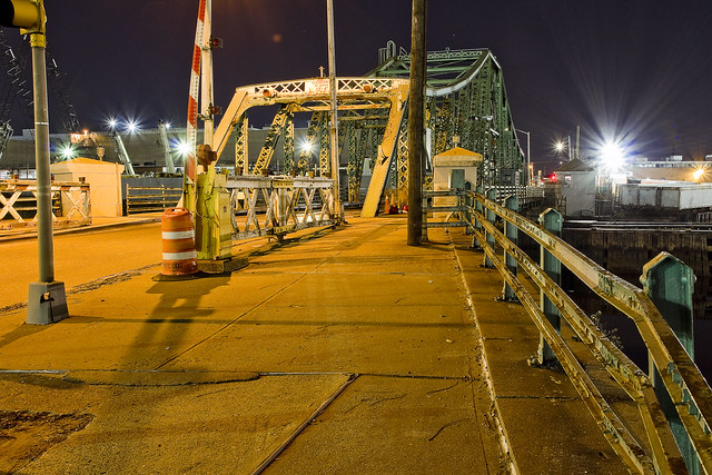
As it happened, when I surmounted the Pulaski Bridge in pursuance of gathering a shot from the span (a photo which was unfortunately blurry due to the transmitted vibrations of passing traffic), workers from the NYC DOT Bridges unit shooed me back along the walkway so that they could safely open the draw bridge for a passing tugboat.
Wasn’t that nice of them?
“follow” me on Twitter- @newtownpentacle
disclosures which
Happy Monday.

– photo by Mitch Waxman
So, this weekend’s nocturnal walk occurred on Saturday night, which was a bit windy for my taste but I’m trying to be out and about as much as possible before proper winter sets in so there you are. Pictured above is Steinway Street, here in Astoria, where i considered getting on the subway in pursuance of getting to LIC but decided it wasn’t worth the risk of daring fate by entering the system. Instead, I scuttled along one of my usual routes, and whilst walking pondered a few things.
Amazon, Queens, life. One of the things I decided to do was put out an open request to you, lords and ladies, in the hope of attaining a point of view for the camera which I’m desirous of.
– photo by Mitch Waxman
Terrestrial is how I’d describe the images I usually capture. The point of view is generally somewhere between ground level and roughly 64 inches from it (that’s how tall my tripod is). That “big project” I’ve been working on is nearly finished, but I’m still missing something, and that’s a nocturnal aerial shot of Newtown Creek. Ideally, I’d love to set up and capture the image from the Empire State Building over in the City, but they don’t exactly encourage that sort of thing on the observation deck unless you’ve got TV Network money to convince them into letting you do so. The last time I was up there, I got a bunch of daytime shots like this one, just so you understand what I need to tie a bow around this project of mine and put it to bed.
If you’re reading this in Manhattan, and live or work between 18th and 34th streets, with visual access to the East River and Newtown Creek… I’d love to try and talk you into letting me set up the gear and record your POV. I’d only need around thirty minutes, on a clear night, well after dark which is about six p.m. or later this time of year. Contact me here (link is to my email address “newtownpentacle@yahoo.com” if it sets off any security alerts, there’s nothing “unkosher” in it) if this sounds like fun. I’ll pay you back with some sort of cool thing or other.
The “full view” of the Creek from on high is what I’m looking for, but if you’re living on an upper floor in one of the new buildings in LIC or Greenpoint and can see Newtown Creek from your windows or roof, that would work as well. Pictured above, as a note, is Skillman Avenue alongside the Sunnyside Yards. Those new bike lanes are barely being used for their intended purpose, but they do make a nice safe spot to take pictures from.
– photo by Mitch Waxman
In the meantime, I’m scratching along in the grit and grime on the streets of Western Queens.
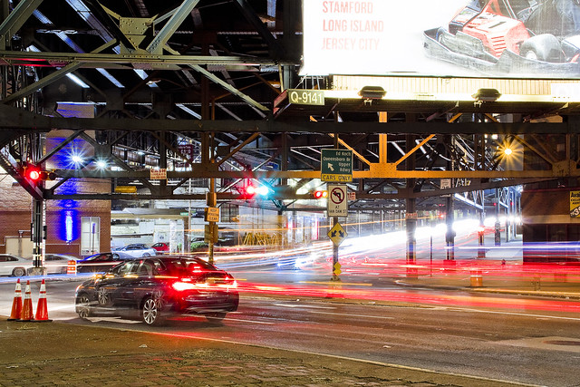
The shot above was captured at the intersection where Queensboro Bridge traffic from Queens Plaza emerges from under the steel of the elevated IRT Flushing line #7 tracks, and travels on one of the five vehicle bridges spanning the trackage of the Sunnyside Yards. Just to the south is Thomson Avenue, which provides another connection for LIC traffic across the Sunnyside Yards via another viaduct, and westwards towards the Court Square section of Hunters Point, and Jackson Avenue. A busy and complicated intersection, this is also where Van Dam Street begins, carrying automotive traffic south towards the Blissville section of LIC and the Greenpoint Avenue Bridge (which overflies the tracks of the Long Island Railroad) after crossing under the Long Island Expressway at Borden Avenue.
“follow” me on Twitter- @newtownpentacle
mechanically performed
What I’m doing, while you’re asleep.

– photo by Mitch Waxman
Given my particularly nocturnal activities of late, it was a shock to the system when I had to arrive at an assignment on the Greenpoint/Williamsburg border yesterday at 7:30 in the morning. It’s been quite common for the last couple of weeks for me to be retiring to the bed at about 4:30-5 a.m. after returning from scuttles about the Newtown Creek with an image packed camera card. Seldom have I been out that late, rather, I’ll get back to HQ sometime just after midnight and then sit down to handle the developing process on the freshly minted pixels.
Pictured above is the Grand Street Bridge as seen from one of the two arms of the East Branch tributary of Newtown Creek. One of the things I find “neat” about these night shots, long exposures all, are details which the limitations of human night vision occluded while in the field. Those whitish gray arcing streaks in the water are reflected light coming from the scales of fishes in the water, which were invisible to the naked eye.

– photo by Mitch Waxman
A bit further up the Newtown Creek, this time along the English Kills tributary, and the Metropolitan Avenue Bridge is in focus. This sort of shot is possible only because of my long sought knowledge of every possible point of view on the waterway, which I’ve spent hundreds if not thousands of hours walking around when the burning thermonuclear eye of God itself is bobbing about in the sky. That’s why I’d recommend not attempting these sorts of shots “cold,” since daylight observations have revealed to me all the spots where various urban snares and dead falls into the water can be found.
In the case of the shot above, the shoreline surrounding the bridge is decidedly unstable, with soils that are subsiding into the water and held together only by tree roots and subsurface pipes.

– photo by Mitch Waxman
Safe as houses, that’s how I’d describe the location this (rare for me) vertically oriented shot of the new Kosciuszcko Bridge was gathered, at the Maspeth Avenue Plank Road site. As above, so below, at the Newtown Creek.
As I’ve mentioned before, I’ve come to detest the LED lighting used on this and many other structures in modernity. This system of lighting creates an out of gamut series of colors, are far too bright, and give an otherwise nicely apportioned bridge the appearance of a garish Greek coffee shop back here in Astoria.
“follow” me on Twitter- @newtownpentacle
adhered to
Grand Street Bridge, in today’s post.
– photo by Mitch Waxman
Before you ask, no, I won’t be talking about Amazon HQ yet. Suffice to say that everybody I know is talking about the news co-announced today by the Dark Prince of Albany and the Dope from Park Slope that the internet giant will be based in LIC at future superfund site Anable Basin, but at this point in time I don’t have enough information about the plan to speak intelligently about its ramifications. Instead, a few night time shots of the venerable Grand Street Bridge connecting Maspeth with East Williamsburgh/Bushwick are on offer.
People argue with me about the Bushwick thing all the time, claiming that the section of Grand Street between Newtown Creek and Vandervoort Street is either Greenpoint or “East Williamsburgh,” to which I respond that it’s not. East Williamsburgh does have historical precedent, but it’s a term popularized by real estate interests. According to the old Ward maps of pre consolidation NYC (prior to 1898), Greenpoint ends at Meeker Avenue which is nearly a mile to the west of Grand Street. Yes, Greenpoint Hospital is indeed in Bushwick. Remember that “Bushwick” is synonymous with 1960’s racial unrest, 1970’s era riots, and a 1980’s crime hotspot during the Crack Wars to certain generations (Ridgewood residents fought like wildcats to have their own zip code that they didn’t share with their Bushwick neighbors, for instance, as their home and car insurance rates were higher than they should have been due to endemic crime). When gentrification came to North Brooklyn, “Bushwick” was not a “desirable brand,” hence the Real Estate Industrial Complex popularized the “East Williamsburgh” moniker for this area instead. That’s changed now, and Bushwick is now a “hot” neighborhood.
– photo by Mitch Waxman
One is paying a bit more attention to the Grand Street Bridge these days than formerly, as the NYC Department of Transporation has announced their intention to replace it with a more modern structure purpose built to handle current traffic needs. The current Grand Street Bridge is the 1903 model, and the third iteration of a crossing between Brooklyn and Queens on this spot. The section of Newtown Creek it crosses is considered a tributary, and it’s called “The East Branch.”
Once upon a time, the East Branch flowed into Ridgewood, where it was fed by freshwater streams and springs trickling down the “ridge” which you’ll discern when walking along Onderdonk Avenue and other eastern destinations. Ridgewood is the beginning of actual geologic rock formations, with all the land west of it being elluvial fill deposited by glacial and riverine flooding. That’s why the zones around Newtown Creek are so flat, if you were wondering. The actual terminal morraine of Long Island begins a bit to the north east at Mount Olivette Cemetery, in proper Maspeth.
– photo by Mitch Waxman
One has been attempting to get as much night shooting around Newtown Creek in as possible before the weather turns bitter cold, which is why you’ve been seeing so much of it lately. I’ve been noticed by a few people wandering around the concrete devastations with a ridiculous yellow safety vest draped over the filthy black raincoat, setting up the tripod and all the other necessary gear needed for the pursuit. With the exception of few encounters with bored but zealous security guards, it’s been a fairly solitary pursuit, although in a couple of locations I opted to bring somebody along with me to watch my back. Frequent commenter and persistent curmudgeon Don Cavaioli was with me at English Kills last week, for instance, but for the shots in yesterday and today’s posts I was on my own.
I’ve been asked about personal security by a few people, but it’s not something I worry too much about. My biggest safety concerns have been centered around not getting squished by a truck, or snapping my ankle on a hidden sinkhole or fallen branch while picking my way around in the dark. If I had to call 911 for help in an emergency, I’d likely have a devil of a time describing where I am to them as I don’t think “Maspeth Plank Road” or “former Phelps Dodge” is necessarily reflected in the municipal system. My plan for such an eventuality would actually involve first calling one of my colleagues at Newtown Creek Alliance, beseeching them to aid in sending rescuers to a humble narrator.
“follow” me on Twitter- @newtownpentacle
immediately arranged
Maspeth Creek, in today’s post.

– photo by Mitch Waxman
There was an unusually low tide last Sunday night, discovered upon my arrival at the Maspeth Creek tributary of the larger Newtown Creek, and if one were to describe the exposed mud flats as being aromatic… that would be a bit of an understatement. Luckily, a humble narrator was alone in the concrete devastations, which provided for an opportunity for derring do and risky behavior. Soon, I found myself perched on a crumbling concrete ledge with a tripod and camera and a two story drop into the stinking mud just one stumble away, with a chain link fence directly behind that my free hand was clutched to. You want to be, always, on the other side of that fence.
This is exactly the sort of thing which I advise others not to do, as it’s stupid and foolhardy, but… I got my shots.

– photo by Mitch Waxman
Once upon a time and just a few blocks away from this spot, DeWitt Clinton sat on his porch and watched a meandering Maspeth Creek flow past his house, when the waterway was navigible half of the way to Elmhurst, and dreamt up the Erie Canal. In the late 19th and early 20th century, Maspeth Creek was described by contemporaries as a “stinking swamp, surrounded by pestilential industries and ugly to the ultimate degree.” By the time WW2 came along, this was where you’d access the bulkheads of the United Enameling and Stamping Co.
In the first quarter of the 20th century, Maspeth Creek was canalized and truncated, with its eastward or landward side being entirely taken over by a large combined sewer outfall concrete vault, and its once upon a time course towards Elmhurst buried into a sewer. In fact, the concrete ledge from which these shots were gathered is the roof of that sewer vault, known to Newtown Creek enthusiasts and Government regulators alike as “NC-077.” This drain reportedly allows about 289 million gallons of untreated wastewater a year to saturate into the tributary and deposit filth into it.

– photo by Mitch Waxman
There were all sorts of critters moving around in the darkness; Geese, Rats, and Raccoons were all personally spotted, but there were other unseen but hinted at forms of life in both the water column and crawling about and along the shorelines. Something fairly large was crashing around in the bush found on the southern bulkheads, but that could have just been some of the Raccoons, or maybe some Opossums. I did not observe anything with tentacles, but I’ve always had certain suspicions about Maspeth Creek, revolving around old Lenape tales suggesting this area as “not being right.”
As far as what might be tunneling, wriggling, or sliding about in the exposed Black Mayonnaise sediment beds… who can guess, all there is, that might be buried down there?
“follow” me on Twitter- @newtownpentacle


