Archive for the ‘Queens’ Category
oh, xolotl, behave

– photo by Mitch Waxman
Another one of the topics which your humble narrator is an absolute geek about happens to involve the pre-Columbian belief systems of the aboriginal cultures which distinguished Mexico and its central American Neighbors to the south. Particularly the Aztec, or Mexica, belief system (Aztec is a spanish word) is something dear to my heart. This is mentioned so that the replete joy I felt at discovering this “cool car” on the corner of 43rd and Northern Blvd. recently might be understood.

– photo by Mitch Waxman
On the hood, or bonnet for anglicized readers, is a lovely little illustration. Ironically presented using western techniques of illustration- it nevertheless depicts an Eagle Knight and Mexica Princess framed against an imposing temple. The central skull face at the bottom of the piece is the earth monster from the “Calendar Stone of Tonatiuh”, and a full size reproduction of said sculpture may be found at the Museum of Natural History in Manhattan.
The Eagle Knights were sort of mesoamerican “Green Berets”, an elite caste of warriors distinguished by a noble birth and the use of specialized training, weapons, and tactics. The Mayan warriors depicted in the popular film “Apocalypto”, in comparison, were Jaguar Knights.

– photo by Mitch Waxman
The shining surprise on this “cool car” was found on the rear view mirrors. I’m sure that the “Ramirez” tag has some sort of modern pop cultural significance which I am unaware of, to which my only reply is “La Raza” as I sweep my spread fingers across my eyes.
Before you ask about the title of this posting- Xolotl was the name of the obsidian glass instrument which was used in the ceremonies of human sacrifice to the sun god Huitzilopochtli and the rain god Tlaoc. The Mexica considered it to be a living being.
antique state

– photo by Mitch Waxman
This post gets involved with a serious bit of pondering, and will ask a naive question that I’m sure somebody else has thought of and discovered some insurmountable barrier to it’s feasibility.. Something I’ve always wondered about, even as a young but already humble narrator back during the fabled 1970’s…
Why don’t MTA trains ever carry commercial freight?

– photo by Mitch Waxman
The fabled “money train”, garbage trains, and track work flatbed cars prove that you can indeed run freight through the light rail system. Loading, and unloading, cargo is accomplished in a timely fashion. The tracks are generally not “tied up” for long by these specialty trains, nor are they chewed up by doing this kind of duty anymore than they would be during rush hour service when the cars are packed to the gills.
I’m not talking rush hour, but middle of the night sort of bulk deliveries, using a miniature form of the ocean going steel shipping container that is deployed on a specialized (non passenger car) to facilitate speedy cargo handling. How many trucks would that take off the road, and what would decoupling the local food economy from the price of gasoline do for New York City?
The subway is already a sort of distributed node network, which carries a cargo of irregularly shaped meat products from one side of the city to the other, why not just add a second class of cargo and a specialized cargo car. The beautiful part of the cargo containerization concept is that it reduces shipping down to a simple calculation of weight and measure multiplied by distance. A ton of cargo is a ton of cargo, doesn’t matter if it’s engine blocks or rice krispies, as long as it fits in a cargo container it costs the same.
Specify a small shipping container size, make it self powered and wheeled and set it to robotically roll off onto the platform where it’s programmed to and await pickup. Getting it to the sidewalk can be accomplished a half dozen different ways, and I’m not talking system wide either. Load on in Queens or the Bronx, and roll off in Manhattan- where all the trucks are coming from and going to anyway.
Why not?

– photo by Mitch Waxman
As long as the cargo is within the bulk limit of what the tracks and undercarriages are designed to do, and given the proximity to truck depot and railhead alike that so many of the outlying MTA depots enjoy, wouldn’t there be some efficacy to using the subways to move commercial goods around the city? I’m not talking bricks here, but food and dry goods delivered to where the population is densest.
Sure the setup process would be expensive, but amortizing the cost out over a generation or two can’t be that painful. Moving a case of bread or cinnamon buns from a bakery in Long Island City to a supermarket in Harlem using an already electrified third rail and a non passenger subway car which has to be cheaper than using a truck. It would certainly be better for the environment, and probably put a lot of people to work over the course of time.
It would add a new revenue stream to the MTA, and guarantee that items manufactured or cooked or just plain created within New York City were immediately advantaged over any competitors from out of town.
Just asking.
incalculable profusion

– photo by Mitch Waxman
The dizzying display of industrial and architectural might on display above distracts the eye from the subject of this post. Empire State, Chrysler, the entire shield wall of Manhattan… even that sapphire Megalith which distinguishes modern Long Island City is screaming for attention. At its base is a white building which is a former printing plant, later an Eagle Electric factory, which has been converted over to luxury condominiums known as the Arris Lofts. At the bottom of the shot is Skillman Avenue and the north side of the Sunnyside Yard with a train transiting along the tracks. In the midst of all this manifest wealth and ambition, it is easy to overlook Thomson Avenue The lower right hand corner of the shot depicts a viaduct structure which allows trains to pass beneath a vehicular roadway which it carries.
An enormous concrete and steel bridge, 500 feet long and 100 feet wide, and it is hidden in plain sight.
That’s Thomson Avenue.
from 1877’s “Long Island and where to go!!: A descriptive work compiled for the Long R.R. Co.“, courtesy google books:
Long Island City is the concentrating point upon the East river, of all the main avenues of travel from the back districts of Long Island to the city of New York. The great arteries of travel leading from New York are Thomson avenue, macadamized, 100 feet wide, leading directly to Newtown, Jamaica and the middle and southern roads on Long Island, and Jackson avenue, also 100 feet wide, and leading directly to Flushing, Whitestone and the northerly roads.
Long Island City is also the concentrating point upon the East river, of the railway system of Long Island.
The railways, upon reaching the city, pass under the main avenues of travel and traffic, and not upon or across their surface.

– photo by Mitch Waxman
To begin with, lets start with the end. Thomson disappears into the modern street grid when it is rudely interrupted by Queens Boulevard. This is the actual slam bang intersection where the “automobile city” of the 20th century meets the “locomotive city” of the 19th. Thomson avenue is centered on the other side of this tripartite intersection, where it meets Queens Boulevard and Van Dam Street.
The “Great Machine” slithers past Thomson, and hurtles eastward along the more modern thoroughfare.
from wikipedia:
Queens Boulevard was built in the early 20th century to connect the new Queensboro Bridge to central Queens, thereby offering an easy outlet from Manhattan. It was created by linking and expanding already-existing streets, such as Thomson Avenue and Hoffman Boulevard, stubs of which still exist. It was widened along with the digging of the IND Queens Boulevard Line subway tunnels in the 1920s and 1930s, and in 1941, the city proposed converting it into a freeway, as was done with the Van Wyck Expressway, but with the onset of World War II, the plan was never completed.

– photo by Mitch Waxman
Thomson adjoins Jackson Avenue on the other side of its run, where their junction forms the so called “Court Square”, which is where the Megalith squats squamously. There used to be a hospital where the colossus now stands.
from wikipedia
One Court Square, also known as the Citigroup Building, is a 50-story (209.1 meters or 686 feet) office tower in Long Island City, Queens just outside of Manhattan in New York City. It was completed in 1990 by Skidmore, Owings & Merrill LLP for Citigroup. The tower is tallest in New York City outside Manhattan, and the tallest building on Long Island. WNYZ-LP, also known as Pulse87.7 broadcasts from the top of this building.

– photo by Mitch Waxman
Overwhelming and out of character with its surroundings, the Megalith is the tallest structure on Long Island, and 53rd highest building in New York City- if you’re impressed by that sort of thing.
from nytimes.com
The building, designed by Raul de Armas of Skidmore, Owings & Merrill, is handsome, even somewhat refined; its pale blue-green glass and transparent windows are obviously intended to reduce the impact of the vast tower on Long Island City, and to a considerable extent they succeed. This building would be a lot more overpowering still if it had been sheathed in reflective glass, or garnished with ornament from top to bottom. And the shape – a tower with stepped-back corners that rises straight up for most of its height, with small setbacks at the very top to create a hint of a pyramid where the building meets the sky – helps a bit more in reducing the apparent bulk.

– photo by Mitch Waxman
Across the street from the Megalith is why they call it Court Square, the Long Island City Courthouse. Famously, this is where master criminal Willie Sutton was supposedly asked “Why do you rob banks?” and the master criminal supposedly replied “Because that’s where the money is”. According to Sutton, an urban legend. Funnily enough, the Megalith houses some of the offices of Citigroup, one of the world’s largest banks.
They don’t keep money here, though.
from nyc.gov
The Long Island City Courthouse is located near the corner of Thomson Avenue and Court Square.
In 1870, before the 1898 consolidation with New York City, the Queens county seat moved from Jamaica to the newly-formed township of Long Island City, which was near all of the train lines. Long Island City was made up of the towns of Astoria and Newtown. Abram Ditmars, the first mayor, had the streets surveyed and paved, brought in a pure water supply and established equitable tax assessments and a regular police force.
The Long Island City Courthouse was built between 1872 and 1876, with delays, scandals and cost overruns. At two-and-a-half stories, built of brick and granite in the French Second Empire style, it became one of the most important buildings in Queens. It was designed by Massachusetts architect George Hathorne. (Hathorne designed Walker Hall at Amherst College, the largest building on campus when it was built in 1870. That building was rebuilt after a fire in 1882 and was torn down 80 years later in 1962.)
The Long Island City Courthouse was gutted by a fire in 1904 and Peter M. Coco was selected to redesign it. A prominent Long Island City architect who trained at the Cooper Institute, Coco designed churches, residences and commercial buildings in the area. Using the foundations and original walls, he added two stories and stripped the building of its then-outmoded ornament, transforming it into a neoclassical style courthouse. He added projected paired Ionic columns to each side of the entrance, which support small balconies. Each has a small helmeted head between the scrolls at the top of the column. The two-story-high entrance is arched, with two dates in the spandrels: ‘1874’ and ‘1908.

– photo by Mitch Waxman
Moving in an easterly direction from Court Square, Thomson finds another connection to the automobile city, as one of the off ramps for the upper level of the Blackwell’s Island… Queensboro… Ed Koch… Bridge, allowing tens of thousands of vehicles to vomit onto Thomson’s parabola every day.
The change in grade is quite noticeable to the inveterate pedestrian, it should be mentioned.
from “Bulletin, Volumes 9-10 By Building Trades Employers’ Association“, courtesy google books
The rapid progress being made in the grading of Sunnyside yard in Long Island City, the future great terminal of the Pennsylvania Railroad system in New York, and the rapid construction of the eight massive viaducts to provide for the highway and railroad crossings, insure the completion of that section of the great undertaking early next fall.
The most massive of the overhead highway crossings is the Thomson Ave. steel viaduct, 100 feet in width and 500 feet in length, passing over the network of tracks of the Long Island and Pennsylvania Railroads at a height of 30 feet. The Queensboro Bridge extension viaduct, crossing diagonally to the street system of Long Island City, but at right angles to the railroad, is 80 feet in width, and has massive steel girders. The Thomson Ave. crossing, which will be completed next month, and the bridge extension will provide for the traffic over the main arteries of travel, extending through the borough from north to south.

– photo by Mitch Waxman
Scuttling around on the side streets which dead end off of Northern Blvd., like Dutch Kills or Queens or Purves streets, one can gain an appreciation for the height of the Thomson Avenue Viaduct. These roadway artifacts used to proceed through what is now the rail yard, and the historical record is full of lawsuits brought against the Pennsylvania Rail Road or Long Island Railroad companies for damages based on the grade situation.
These law suits detail and define the complicated questions of who owns what around and above the yards.
from 1913’s “2 years transportation progress, Volume 140“, courtesy google books
“perpetual easement or easements for the rights to continue and maintain the said viaducts or bridges over the following streets or avenues as nowlaid out or proposed: and will thereby grant to the city a perpetual easement or easements sufficient for the use and control by the city of the said viaducts and bridges for the purpose of police regulation and other control contemplated by the city ordinances for the care of streets or highways, excepting and reserving, however, to the said companies the right to construct and maintain, at its or their own expense, such connections between the said viaducts or bridges, or any of them, and the property of the said companies, as shall not interfere with the use of the said viaduets or bridges for street purposes.”
Then are specified several viaducts, and as to the one over Thomson avenue it is said:
“The said viaduct or bridge over the proposed Sunnyside Yard on the line of Thomson avenue, hereinbefore in paragraph 1C, set forth, including the right to the city to increase, at its own expense and without interfering with the operation of the said Sunnyside Yard, the width of said viaduct to beone hundred feet”
The intention of the companies was to enlarge the terminal laterally by acquiring from! the city title to the land in the closed streets wherever necessary, and by acquiring the lands abutting thereon from private owners. To do this it was necessary to close the streets across the right of way as broadened, so that the companies could have the fee and possession thereof for railroad purposes. But in some instances, and among them at Thomson avenue, in the place of the portion of the street closed and agreed to be sold a viaduct over the yard was provided and built, and it was necessarily so high over the tracks that the grade of the avenue at either end was necessarily raised to meet it. In other words, over the space where the avenue was obliterated and its bed agreed to be sold a bridge was built, and the abandoned portion made a part of the terminal facilities.

– photo by Mitch Waxman
The Sunnyside Yard tends to insulate Long Island City from the rest of western Queens, forcing its residents and businesses to pass through narrow or crowded choke points when leaving or entering the locale. The landward passages along the East River are defined by the Queensboro, while the southern ridge that overlooks the yard leads to Sunnyside. The other viaducts which cross the yards- Hunters Point Avenue, Thomson Avenue, Queens Blvd. are all orientated in a mostly easterly direction, while the the 35th street or Honeywell Bridge, and the 39th street or Harold Avenue bridge at Steinway Street offer rare and spread out pinchpoints of north south egress across the facility.
The businesses which set up shop around Sunnyside Yard in the early 20th century didn’t much care, they were part of the locomotive city.
Pictured above, one might observe the traffic barrier and pedestrian shed which manifests itself at roughly the 50% mark on the Thomson Avenue viaduct.
from 1913’s “Greater New York: bulletin of the Merchants’ Association of New York, Volume 2” courtesy google books
After luncheon, which was held in the cosy quarters of the Queens Chamber of Commerce on the Bridge Plaza, Long Island City, the party were taken on an automobile drive of about fifty miles, covering the principal points of Industrial interest in Queens.
Great Industries Established
The first stop was made on Diagonal Street which crosses the Long Island Railroad yards. From this point it is possible to see all the features of the industrial development in that part of Queens, especially the development of the Degnon Terminal Company and the new factory of the Loose-Wiles Biscuit Company.
The party then proceeded along Thompson Avenue to Newtown Creek, passing some of the largest factories in Queens, and also the most important industries in New York City, such as the Nichols Copper Company, the General Chemical Company, the National Enameling and Stamping Company, the General Vehicle Company, which is just erecting a large new building, and the Brunswick-Balke-Collender Company.

– photo by Mitch Waxman (note: for the entire post on this burning Amtrak train, click here)
The tracks which Thomson Avenue forms a bridge over are used by Long Island Railroad, Amtrak, and New Jersey Transit (which stores some of its extra daytime capacity in Sunnyside Yards between rush hours). The shot above, which was originally presented in the post Sinister Exultation, depicts an Amtrak engine having a bit of immolation trouble. The section of the yard between Hunters Point and Thomson is (or at least used to be) referred to as “Yard A”.

– photo by Mitch Waxman
From Skillman Avenue, the structure of the Thomson Avenue viaduct is visible as it’s begins to roughly slouch back to the grade level of the surrounding streets. The Sunnyside Yard allows locomotive access to the New York Connecting Railroad, which connects Long Island to the rest of the continent via the Hell Gate Bridge. Sunnyside Yard continues all the way to Woodside, and sits on an astounding 8,500 feet footprint which consumes 192 acres and offers an unbelievable 25.7 miles of track. Historical records discuss the gargantuan task of reclaiming this swampy land for use as a rail yard, as seen in the snippet below.
from 1910’s “New York tunnel extension, the Pennsylvania railroad: description of the work and facilities, Volume 2“, courtesy google books
Originally, a swamp of 40 acres extended from the present location of Honeywell Street and Jackson Avenue to Thomson Avenue, and comprised a portion of the required Yard area; the remaining 168 acres within that area was rolling ground from 10 to 70 ft. above the swamp. Upon this high ground there were 246 buildings of all kinds, and these were purchased and torn down or removed. A view of the swamp in the early stages of the work is shown by Fig. 1, Plate XLV. A vegetable growth, of the nature of peat, from 1 to 4 ft. in thickness, formed the surface of the swamp, except in the bed of Dutch Kills Creek; beneath this there was a layer of mud, and in the bed of the stream a blue-black clay of the consistency of putty. As this muck and clay would move under the pressure of the filling over it, and produce waves of considerable height, it was specified in the contract that a blanket of earth about 4 ft. thick should be first placed over this part of the Yard area, in order to prevent this wave formation. This proved efficacious, except in one or two places, where, owing to unusual depth of filling, the wave formation broke through this covering and rose to such a height as to require excavation of the peat, muck, and mud, in order to secure proper track foundations. In the bed of Meadow Street, where the embankment was very high, the crest of one of the mud waves rose to an elevation of 28 ft. above the swamp.

– photo by Mitch Waxman
The naming of Thomson avenue has always been a bit of a mystery for your humble narrator. Skillman, for instance, was named for a farmer that supported the British during the American Revolution whose lands were confiscated by the victorious rebels (much like DeLancey over in Manhattan). Apparently, there were one or two LIRR and or Pennsylvania RR executives named Thompson- and certain older documents refer to this road as “Thompson Avenue” but this is a common typographic error which favors the more widespread surname.
There was a Thomson that was an important member of the Queens Chamber of Commerce during the 1920’s but the street dates back to the beginnings of Long Island City and must be named for someone earlier.
from nycroads.com
HISTORY OF QUEENS BOULEVARD: Originally called Hoffman Boulevard, Queens Boulevard dates back to the early years of the twentieth century, when the road was constructed as a connecting route between the new Queensboro (59th Street) Bridge and central Queens. In 1913, a trolley line was constructed from 59th Street in Manhattan east along the new boulevard.
During the 1920′s and 1930′s, New York City began a program to widen Queens Boulevard. The project, which was conducted in conjunction with the building of the IND Queens Boulevard subway line, widened the boulevard to 12 lanes in some locations, and required a right-of-way of up to 200 feet. Once completed, local and express traffic flows were provided separate carriageways.
uncommented masonry

– photo by Mitch Waxman
It all started when I was checking to see if I could find out anything more about the Blissville Banshee.
As the sum total of that which might be gathering dust on library shelves has not yet been digitized, categorized, and assigned metatags- there is an awful lot of stuff which is not available to the prying eyes of primarily nocturnal creatures like myself. Google books is an ongoing project, for instance, and every month or so some new (old) document appears online which is Newtown Creek oriented that I might slaver over.
from wikipedia
Google Books (previously known as Google Book Search and Google Print) is a service from Google that searches the full text of books that Google has scanned, converted to text using optical character recognition, and stored in its digital database. The service was formerly known as Google Print when it was introduced at the Frankfurt Book Fair in October 2004. Google’s Library Project, also now known as Google Book Search, was announced in December 2004.
Results from Google Book Search show up in both general web search at google.com and through the dedicated Google Books site (books.google.com). Up to three results from the Google Books index may be displayed, if relevant, above other search results in the Google Web search service (google.com).

– photo by Mitch Waxman
Hence my periodic searches conducted for topics of which I’ve heard only hints of in the past- Case’s Crew for instance, or the aforementioned Blissville Banshee. It was one of these fishing expeditions into the ever expanding archival universe of the vast inter webs that led me to a certain structure, which sits at 30-28 Starr Avenue, just a couple of blocks from that malignant exemplar of the price of unregulated capitalism known as the Newtown Creek. It’s ordinary enough looking, branded with corporate logos and quite visible from many parts of Long Island City and Brooklyn.
from the Friends’ intelligencer, Volume 35, courtesy google books
The early history of Friends in Newtown and Maspeth Kills is marred by the irregularities of the Ranters, who claimed to be Friends, and intruded on their meetings.
Such was Thomas Case, who (1674) was forbidden by the Court to entertain the wife of William “Smith. His wife, Mary Case, was fined £5 for interrupting Rev. William Leveridge, while preaching, by saying to him: “Come down, thou whited wall that feedest thyself and starvest the people.” Samuel Scudder sent a long, scandalous letter to Mr. Leveridge.
The Court put Case and Scudder under bonds not “to seduce and disturb the people.”

– photo by Mitch Waxman
Let’s start at the beginning, though.
Borden Avenue is one of the older pathways in New York and particularly so for Queens, as the modern street was designated as Borden Avenue in 1868. It allowed egress from the docks at Hunters Point to the incalculably far Newtown and passed by the thriving village of Maspeth along the way. Originally a plank road set roughly into the swampy lowlands which adjoined the Newtown Creek, what would become Borden Avenue eventually progressed to the point of regular horse drawn (and then electric) street car service by the late 19th century and beginning of the 20th. It became a natural place for heavy industries to gather, and in the 1870’s and 80’s, rail road switches and “rights of way” followed their customers here.
The Long Island Railroad terminal at Hunters Point is and was on Borden Avenue, and rail tracks run parallel to Borden Avenue’s path, along what would have once been known as Creek Street. Critically, these were both freight and passenger tracks.
As of 1908, a retractile vehicle bridge crossed Dutch Kills, which we call the Borden Avenue Bridge (and which replaced the earlier wooden plank road drawbridge).
Today Borden is severed and overran by the sprawling girders of the Queens Midtown Expressway section of the much larger “Long Island Expressway”, and most of the tracks which crossed it at grade are cut or buried in the road asphalt.
from wikipedia
The Long Island Expressway was constructed in stages over the course of three decades. The first piece, the Queens–Midtown Tunnel linking Manhattan and Queens, was opened to traffic on November 15, 1940. A highway connecting the tunnel to Laurel Hill Boulevard was built around the same time and named the “Midtown Highway”. The tunnel, the Midtown Highway, and the segment of Laurel Hill Boulevard between the highway and Queens Boulevard all became part of a realigned NY 24 in the mid-1940s. In the early 1950s, work began on an eastward extension of the Midtown Highway. The road was completed to 61st Street by 1954, at which point it became known as the “Queens–Midtown Expressway”. By 1956, the road was renamed the “Long Island Expressway” and extended east to the junction of Queens (NY 24 and NY 25) and Horace Harding (NY 25D) Boulevards. NY 24 initially remained routed on Laurel Hill Boulevard (by this point upgraded into the Brooklyn–Queens Expressway) and Queens Boulevard, however.

– photo by Mitch Waxman
Borden Avenue once formed the border of a community called Blissville (named for it’s founder and designer, Neziah Bliss of Greenpoint) which was meant to be an ideal residence for industrial laborers. It was, for a while.
Calvary Cemetery was sited in Blissville in 1848, which literally ate half the neighborhood, and the industrial concerns which employed the local labor had taken up valuable waterfront properties at the Newtown Creek. These industrial entities were notoriously onerous neighbors whose factories rendered Blissville a stinking slum and literally the wrong side of the tracks.
Dutch Kills and the land surrounding it to the south west were considered to be a pestilential swamp best known for malaria, and upstream from Blissville were the bone boilers and fat rendering factories so conspicuous in the historical record for a wholesale degradation of the environment. Suffice it to say that the population of Blissville declined precipitously from 1850 to 1900, from a residential point of view (although people still live here, even today).
from wikipedia
Blissville is a neighborhood in the New York City borough of Queens. It is part of Long Island City. It is bordered by Calvary Cemetery to the east; the Long Island Expressway to the north; Newtown Creek to the south; and Dutch Kills, a tributary of Newtown Creek, to the west. Blissville was named after Neziah Bliss, who owned most of the land in the 1830s and 1840s. Bliss built the first version of what was known for many years as the Blissville Bridge, a drawbridge over Newtown Creek, connecting Greenpoint, Brooklyn and Blissville. It was replaced in the 20th century by the Greenpoint Avenue Bridge, also called the J. J. Byrne Memorial Bridge, located slightly upstream.
Blissville existed as a small village until 1870 when it was incorporated with the villages of Astoria, Ravenswood, Hunters Point, Dutch Kills, Middletown, Sunnyside and Bowery Bay into Long Island City.

– photo by Mitch Waxman
At the end of the 19th and beginning of the 20th centuries, a Cambrian explosion of “scientific manufacturers” (which is an actual and atavist business terminology from the time) arose within the industrial quarters of the United States and especially around the Newtown Creek. Great corporations were born along the creek, in the fields of chemical manufacturing and metal refining, petroleum refining and distribution, electrical generation and supply, and especially the field of automotive vehicle manufacturing.
There were now machines that could fly, or mechanically navigate the seas, but it was the automobile which struck hardest in the public’s mind and ending up driving the national economy.
from wikipedia
By the early 1880 generators were beginning to power arc lamps in Britain and France, but they generated high temperatures and sparks that prevented widespread adoption. In 1880, Thomas Alva Edison developed and patented a long-lasting incandescent lamp based upon the previous work of many inventors. Like Bell, Edison immediately set about commercializing his invention through a shrewd business plan involving companies that would manufacture the whole technological system upon which the “light bulb” would depend – generators (Edison Machine Company), cables (Edison Electric Tube Company), generating plants and electric service (Edison Electric Light Company), sockets, and bulbs. As in other industries of the era, these companies achieved greater efficiencies by merging to form a conglomerated General Electric company. Lighting was immensely popular: between 1882 and 1920 the number of generating plants in the US increased from one in downtown Manhattan to nearly 4,000. While the earliest generating plants were constructed in the immediate vicinity of consumers, plants generating electricity for long-distance transmissions were in place by 1900. To help finance this great expansion, the utility industry exploited a financial innovation known as the “holding company”; a favorite holding company investment among many was the Electric Bond and Share Company (later much-changed, and known as Ebasco), created by the General Electric company in 1905. The abuse of holding companies, like trusts before it, led to the Public Utility Holding Company Act of 1935, but by 1920, electricity had surpassed petroleum-based lighting sources that had dominated the previous century.

– photo by Mitch Waxman
In an age before refrigeration, being a “locavore” wasn’t an ethical or fashionable choice, it was a necessity.
The speed of a horse and wagon could never be considered dependable though, especially when carrying a heavy load of perishables from say… Bosjwick to Blissville. Whether it was meat, milk, or especially beer- it had a quick shelf life whether it suffered under the gaze of the burning thermonuclear eye of god itself or endured the freezing temperatures of a New York winter.
Additionally, a horse needed rest and food and water, which all needed to be prearranged. Horses also had a tendency to die from overwork. The automotive craze began when the brewers of beer realized what some contrivance called a “truck” could do.
from wikipedia
The word truck might have come from a back-formation of truckle with the meaning small wheel, pulley, from Middle English trokell, in turn from Latin trochlea. Another explanation is that it comes from Latin trochus with the meaning of iron hoop. In turn, both go back to Greek trokhos meaning wheel from trekhein that meant “to run”. The first known usage of “truck” was in 1611 when it referred to the small, strong wheels on ships’ cannon carriages. In its extended usage it came to refer to carts for carrying heavy loads, a meaning known since 1771. With the meaning of motor-powered load carrier, it has been in usage since 1930, shortened from motor truck who dates back to 1916.

– photo by Mitch Waxman
The reason that so many parts of the Newtown Pentacle host a former brewery, not unlike the Ulmer site in Bushwick, is that Beer didn’t used to come in bottles or pressurized kegs but was instead shipped in barrels. These barrels were delivered daily, which meant that the brewer had to be centrally located to service the various saloons, beer gardens, and bars which formed it’s clientele. This called for an eternal struggle against random happenstance, and the relatively shallow load that a horse cart was capable of carrying created high labor and livestock costs and limited growth. Suffice to say that the beer brewers needed a more reliable form of transportation that could handle the heavy products they produced.
The automotive “truck” could work all day and night with one driver, and carry many times the tonnage possible with a carriage.

– photo by Mitch Waxman
Blissville had long ago rebelled against the baronial farmers of Newtown and joined with its ancient sisters in forming Long Island City, which would become an early center for automotive manufacture. The political elites of Manhattan, who had just engineered the consolidation of the City of Greater New York, were anxious to develop western Queens and land was cheap for the well connected. Vast building lots were sold, and an incredible landscape of titan masonry was flung at the sky, with the intention of capturing and controlling vast amounts of treasure and discovering untold possibilities.
from wikipedia
The City of Greater New York was a term commonly used originally to refer to the expanded city created on January 1, 1898 by the incorporation into the city of Richmond County, Kings County, Queens County, and the eastern part of what is now called The Bronx (east of the Bronx River). The west Bronx, west of the Bronx River, had been annexed to the City and County of New York in 1874, and was known as the Annexed District. The City of Brooklyn had also expanded by annexation.
The phrase City of Greater New York was never a legal or official designation as both the original charter of 1898 and the newer one of 1938 use the name of City of New York.
The consolidation movement was the work of several progressive politicians, most prominently Andrew Haswell Green so some opponents derided the effort as “Andy Green’s hobby.” The center of the plan was the consolidation of the twin cities of New York and Brooklyn, whose fire departments had already been consolidated. The addition of Long Island City and various rural areas anticipated the spread of urban sprawl to those areas. With the Republicans historically more powerful in Brooklyn and the Democrats elsewhere, partisan politics played a role, each major political party hoping to dominate the consolidated city.

– photo by Mitch Waxman
By 1915, there approximately 40,000 automotive trucks plying the streets of New York City.
What’s surprising is that 25% of them were electric.
Lords and ladies of Newtown, I present to you the last mortal remains of the General Electric Vehicle Company, 30-28 Starr Avenue, Long Island City– manufacturer of a substantial number of those electrical trucks.
Here’s the way the place looked just before the time of the first World War, courtesy google books
Another historic view can be seen in this nytimes.com archive article

– photo by Mitch Waxman
General Electric Vehicle Company was originally the Electric Vehicle Company, until it was acquired by one of those “scientific manufacturers”- a small but growing firm which called itself “General Electric“. GE was a direct creation of a fellow named Edison, whose little power generating concern in NYC hadn’t quite “consolidated” itself yet.
General Electric Vehicle, like all automotive companies, was in competition with an upstart from the midwest named Ford. Things hadn’t been decided yet, from a consumer point of view, between electric motors or gasoline ones, but there was another company out there which had strong feelings on the subject called Standard Oil.
I’ve read allusions to some deal between Ford and Edison to stay out of each others way, but for awhile Edison was manufacturing (and driving) electric cars.
Here’s A GEVC truck from 1906, courtesy google books

– photo by Mitch Waxman
In the early 20th century, this was the second largest factory space in Long Island City (after the Loose Wiles bakery) sitting on 3 entire blocks of the 19th century street grid and comprising some 8 square acres. 2,000 people worked there. The largest of the structures, which has been conspicuously displayed throughout this post, survives and serves modernity as a gargantuan self storage facility. Other structures of the complex survive, and remnants of the rail spar that served it can be observed on Review Avenue just beyond Borden. Part of its footprint is occupied by the Silvercup Studios East location.
GEVC became the premier manufacturer of Electric Vehicles here, as well as being the only concern in the Untied States licensed to build Daimler’s “Mercedes” gasoline cars and trucks.
from The American review of reviews, Volume 51 By Albert Shaw, courtesy google books
The big principle is that electricity is now the world’s best source of power, and enables business men to “team by electricity.” The Company long ago learned that the work to be performed decides the building of the vehicle. But very interesting is the fact that while all the six G. V. models but one were standardized seven years ago, each truck is built to fit the industry, the locality, and the use it will meet. Starting with a standardized chassis, a body suitable for a given business is built and placed on the chassis, but not before experts have adjusted battery, motor and speed to fit local road conditions. That is, the “power plant” of a 2-ton truck as revealed in battery, motor, etc., is specifically adapted to hilly
Seattle or level Washington, D. C, as the case may be. In the splendid Long Island City plant of the General Vehicle Company the exact facts of the customer’s condition and his locality now determine what that truck must be to succeed. And it does succeed. The haphazard peddling of job-lot trucks must disappear, just as the stock-jobbing era has passed in automobile truck manufacture.
Consequently you can buy an electric truck to-day with the same certainty of what it will do under your particular circumstances as you can buy any other staple commodity. A concern like the General Vehicle Company will actually refuse to sell you a truck which is not what your work requires. It will not promise you all kinds of free service, new tires, free bodies, and free rebuilding. It does not have to do this, as the now bankrupt concerns did have to, in order to try to offset the serious deficiencies in the service a truck was supposed to give. A General Vehicle truck does what it is built to do—and is sold on a business basis, with no secret about what will happen to the man who buys it after he has used it awhile. A table of standard costs to fit various types, conditions and requirements, works out as accurately as a multiplication table.

– photo by Mitch Waxman
General had an interesting scheme to power the trucks, which involved the shipping of batteries to and from a power plant in Connecticut, which would charge industrial base rates for charging them. A series of labor actions and the emerging predominance of the gasoline powered internal combustion engine served to weaken and eventually bankrupt General, and the company was ultimately done in by the first World War because of that Daimler contract.
Nobody wanted German cars or trucks anymore, you see.
In 1918, the War Department of the United States engineered the sale of the plant to the Wright Martin Aircraft company, in order to facilitate the manufacture of airplane engines at the factory. When Wright Martin took over, the payroll skyrocketed to include an astounding 8,000 employees.
from wikipedia
In order to overcome the limited operating range of electric vehicles, and the lack of recharging infrastructure, a exchangeable battery service was first proposed as early as 1896. The concept was first put into practice by Hartford Electric Light Company through the GeVeCo battery service and initially available for electric trucks. The vehicle owner purchased the vehicle from General Vehicle Company (GVC, a subsidiary of the General Electric Company) without a battery and the electricity was purchase from Hartford Electric through an exchangeable battery. The owner paid a variable per-mile charge and a monthly service fee to cover maintenance and storage of the truck. Both vehicles and batteries were modified to facilitate a fast battery exchange. The service was provided between 1910 to 1924 and during that period covered more than 6 million miles. Beginning in 1917 a similar successful service was operated in Chicago for owners of Milburn Light Electric cars who also could buy the vehicle without the batteries.

– photo by Mitch Waxman
Wright Martin Aircraft– Wright as in Wright Brothers, and Martin as in Martin Marietta, departed the place at some indeterminate point in the early 20th century. References have been found which identify the interim tenants of the structure as having been engaged in the manufacture of exotic lithographic and photographic equipment, includes both industrial landscaping and floral supply businesses, and a host of smaller operations involved in warehousing, interstate shipping, and local trucking companies also called this building home base. Ultimately, it became a self storage warehouse.
This is building 3 of the General Electrical Vehicle Complex, there were at least 7.

– photo by Mitch Waxman
Contemporaneous accounts of the place describe it as occupying a spot between Review, Starr, and Borden avenues, bounded by the no longer mapped Fox and Beaver streets. Certain sources and allies were taken aback by my queries about the two streets, thinking that your humble narrator was being ribald, but such profane interpretations of my question were later greeted with scans of a historical map (which I cannot present here for copyright reasons) that confirmed the location and identity of the modern structure.
Suffice to say that Fox and Beaver follow the course set by 30th street and 31st place were they to continue to the Newtown Creek waterfront.

– photo by Mitch Waxman
An effort was made to contact the employees of the self storage warehouse, and though they were thoroughly friendly and attentive, the current staff were somewhat taken aback by my queries. I displayed the historic shot of the building, but they did not have any anecdote to offer about historic remnants or curious machinery, which means that the structure must have been thoroughly gutted before modern times.
You never know what you’re going to find along the Newtown Creek, as I always say, but I’m still wondering about the Blissville Banshee.
quite convinced
– photo by Mitch Waxman
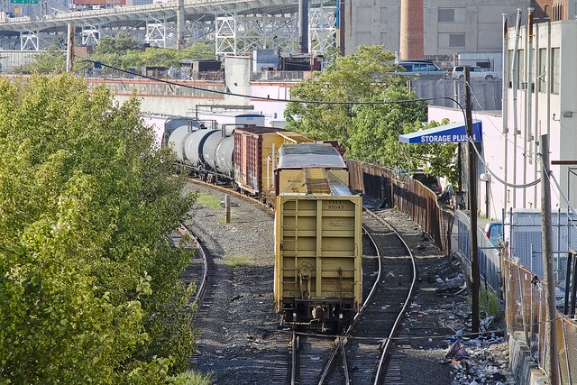
Recent financial setbacks and personal problems infect your humble narrator with a form of deep melancholy and a vast ennui. When such moments come upon me, there is a certain pizzeria in Greenpoint (Norman corner of Manhattan, near the train) whose offerings can be summed up best as: an actual and old fashioned “Brooklyn Slice”. On the day I spied this collection of rail cars at the so called “Bliss Tower” in DUGABO, I had scuttled forth from the rolling hillocks of my beloved Astoria in pursuit of one of these aforementioned slices, in an effort designed to brighten my mood.

– photo by Mitch Waxman
Errors and omissions mar my record when discussing the Rails, much to the chagrin of the knowledgable railfan community (whose helpful comments and corrections are always appreciated here at Newtown Pentacle). As such, what I can categorically tell you is that this a New York & Atlantic Locomotive, one of the 11 engine units which service the 269 miles of track operated upon by the Glendale based company in Brooklyn, Queens, and both Nassau and Suffolk counties. It shares much of its road with the passenger based Long Island Railroad, and NY&A’s distinctive emerald, white, and black engines are regularly observed around the Newtown Creek.

– photo by Mitch Waxman
Across the Newtown Creek Watershed, one encounters a landscape built for rail. Long abandoned track beds lie buried in inches of road asphalt, pointing the way to industrial giants long absent. Train stops orphaned from their purpose, spars and switches which were rudely severed to make room for modernity. All of it operated at street grade, and the remnants of the iron road are often the only tangible remains of great concerns and financial largesse. If you follow the right spar, you’ll discover that the NYPD Barricades unit was once Thypin Steel, or that LaGuardia Community College was once the Loose Wiles bakery and part of the Degnon Terminal.

– photo by Mitch Waxman
Within the communities which surround the Newtown Creek, a complaint often repeated concerns the presence of large numbers of trucks utilizing local streets in their quest to move goods from A to B. I had the privilege last year of attending a presentation by certain factions within the Port Authority that described a proposal which would eliminate several thousand truck trips a day throughout the City and over the George Washington Bridge, simply by shipping New York City’s garbage out to land fill utilizing locomotive rather than automotive means. Calculations about air pollution, road maintenance costs, and vehicular accident rates were presented at the time which compared rail quite favorably with truck based shipping.There was a maritime component to the plan as well, which was a bit hazy, but the train concept was spun gold.

– photo by Mitch Waxman
The shot above represents an NY&A Locomotive making a drop off of a customer in Maspeth near the ill fated St. Saviour’s church site, where they will uncouple a car or two for the unloading or loading of certain cargo. An unthinkable amount of trucks would be required to carry the same tonnage. The subject of Green Technology and “Greening New York” is often bandied about by many these days. Too much of the conversation, however, is “cocktail party environmentalism”- which sounds great but just isn’t practical on a policy level.
I’ve developed this funny notion, however, that the way forward is actually to re-imagine and re-invent the heaviest industry of them all.

– photo by Mitch Waxman
Rail infrastructure is what made Long Island City the factory of not just New York, but the entire world at the turn of the last century and multiple generations of capitalists and real estate interests founded vast fortunes because of the initial investment in it. Newtown Creek was the busiest waterway in North America, carrying more ship and barge traffic than the entire Mississippi for a time, and all of that maritime activity was fed by rail. Intermodal rail floats actually carried whole trains across the harbor to Manhattan, Staten Island, New Jersey and beyond. Imagine the benefits, in both individual wealth and environmental health, were we to try and save the future by looking for solutions in the past.
I’m still kind of forming this idea up for myself, but the key to it is containerization. More on this soon.
What do you, lords and ladies, think on the subject? Use the comments “Reply box” below, if you would like to start a conversation about it.


