Archive for the ‘LIRR’ Category
suitable account
Happy Friday, shut ins.

– photo by Mitch Waxman
Wandering, always wandering, that’s me. I also formulate questions while walking, along, like “why do the people who have moved into the new developments in Long Island City eschew the use of drapes or Venetian blinds.” Also, while pondering subjects which randomly involve aspects of law, the proper cooking of pork, or societal engineering, one considers both past and future.
The lockdown here in NYC began shortly after the night of a full moon which coincided with Friday the 13th. The Ide of March, I believe, is when the Governor began exerting himself in muscular fashion. It’s now a month later – the Ide of April, as it were – and recent news reports have informed that not only has Krakatoa erupted but there’s also an asteroid which will be passing closely (in celestial terms) past the earth. There’s also a plague of locusts devouring Eastern Africa, but there’s always locusts in East Africa so that’s not really surprising. I’ve got a pot of ram’s blood to paint on my door, just in case the streets begin to fill up with hordes of toads or frogs.
Amphibians come in hordes, no? I know crows come in murders.

– photo by Mitch Waxman
One somehow managed to pull off a hand held shot at 1/60th of a second just above, which is a new record for me. Normally, 1/100th is the best I can do on hand held shots before motion blur induced by my breathing and blood circulation obfuscates detail and sharpness.
That’s a near empty LIRR train riding through the Harold Interlocking at the Sunnyside Yards pictured, if you’re the curious type. I am.
Saying that though, my mind is dulling due to all the isolation, and Our Lady of the Pentacle and myself are developing a regional accent particular to our apartment.
Zuzoop the dyg has nary an idear whut we’s be speakins to hur in this new patois, but treats be rain on hur so no worry.

– photo by Mitch Waxman
Tripod based exposures continue to be gathered, on the other hand, and a particularly productive walk over to Dutch Kills in Long Island City the other night will be described in some detail next week. It turns out that I had randomly and unintentionally turned up there during a so called “king tide” which saw the turning basin of Dutch Kills full up to the brim with Newtown Creek juices.
There were critters a splishing and a splashing in the darkness, and those disagreeable Canadian Geese are back in town, having ignored all travel restrictions. More on all this next week at this – your Newtown Pentacle.
Note: I’m writing this and several of the posts you’re going to see for the next week at the beginning of the week of Monday, April 13th. My plan is to continue doing my solo photo walks around LIC and the Newtown Creek in the dead of night as long as that’s feasible. If you continue to see regular updates as we move into April and beyond, that means everything is kosher as far as health and well being. If the blog stops updating, it means that things have gone badly for a humble narrator.
“follow” me on Twitter- @newtownpentacle
Buy a book!
“In the Shadows at Newtown Creek,” an 88 page softcover 8.5×11 magazine format photo book by Mitch Waxman, is now on sale at blurb.com for $30.
sequestered cabin
What’s expected?

– photo by Mitch Waxman
That’s the first phase of the Hudson Yards project pictured above. What’s expected of one such as myself would be to condemn, criticize, or condemn the place. Yes? Ok then.
Here’s my three “C’s.” I personally find the design of Hudson Yards to be quite off, given its total embrace of 75 years old urban planning chestnuts like “superblocks” and “towers in a park.” Hudson Yards ignores its surrounding neighborhoods contextually, offers a harsh and unfriendly pedestrian space, and is guilty of architectural banality. No thought seems to have been given on the subject of its relationship to the position of the burning thermonuclear eye of god itself’s journey through the sky, as the reflective tower facades cause harsh light to broadcast and strobe about from on high. Even sunglasses won’t help when walking westwards on 32nd or 33rd streets in the morning, or eastwards from the Hudson coast of Manhattan in the afternoon/evening.
Walking through the “zone,” I was keenly aware of how unwelcoming the place seemed, displaying emotional sterility while trying too hard to be “artsy.” Every design attempt at being “playful or whimsical” reminded me of a crass and cheaply rendered version of Disneyworld. Rust, peeling paint, and cracked cement is already visible on and around the “Bloomberg Building” for instance.
Homogeneity is what the City Planners like, and in Hudson Yards their vision is writ large. These folks hate the heterogenous chaos of cities, preferring the neat appearance of shopping mall gallerias. Long story short, I’m not a fan.

– photo by Mitch Waxman
On the other hand, gazing upon these shots, which were gathered up on the High Line, I have to remind myself what used to be here – which was a whole lot of stuff nobody wants. Long corridors of graffiti covered concrete walls vouchsafing the rail yards below, open air drug dealing, and more prostitutes than you could shake a stick at (pun intended). This was a “dead” section in busy midtown Manhattan, incongruously sandwiched in by neighborhoods that didn’t end two to three blocks short of the Hudson. The long eastward trek from the Javitz Center for convention goers back to the subways and Penn Station, the automobile commuter focused street design… the west side in the 30’s was never a destination you’d want to tell your mom you were heading towards.
Is this incarnation better? Worse? Only time will tell.

– photo by Mitch Waxman
What I can tell you, after walking the camera through and reviewing the photos gathered, is that every single minute I’ve spent opposing the Sunnyside Yards proposals here in Queens has been time well spent. The fancy pants crowd which is in favor of the gargantuan endeavor of decking the Sunnyside Yards doesn’t really understand what it would entail. They haven’t fully digested the reality of the construction or come to the understanding that to justify the colossal $22 billion estimated cost of the deck, you cannot build small or even medium – you have to build big. That’s an economic reality.
Look at that shot above, and imagine you’re standing in Queens Plaza. Now you’re starting to realize what’s what and why we have to keep this from happening in Queens.
“follow” me on Twitter- @newtownpentacle
Buy a book!
“In the Shadows at Newtown Creek,” an 88 page softcover 8.5×11 magazine format photo book by Mitch Waxman, is now on sale at blurb.com for $30.
was invariable
DUPBO, in LIC.

– photo by Mitch Waxman
Down Under the Pulaski Bridge Onramp, or DUPBO in Long Island City, is pictured above. Recent endeavor found one wandering around this area just after sunset about a week ago, and one decided to get busy with the camera.
The Pulaski Bridge was built by the NYC DOT as a replacement to the older Vernon Avenue Bridge which was found about a block or so to the west. The old bridge connected LIC’s Vernon Blvd. with Greenpoint’s Manhattan Avenue, and there was a streetcar or trolley service which connected the two shorelines of Newtown Creek. The former Orchard Street (bet Greenpoint Avenue and the Creek) in Brooklyn was renamed “Manhattan Avenue” about 1915 (I believe, and that’s from memory so don’t trust me on that), as the LIC side offered proximity to the brand new IRT Flushing line (the 7) subway. The trolley stop in LIC, where the trolley came to rest, is the NYC Parks Dept.’s “Vernon Mall” today. Back then, you named streets for where they were going, today you give parks meaningless names which obfuscate the past, but that’s why Greenpoint’s Orchard Street is Manhattan Avenue today.

– photo by Mitch Waxman
The derelict shoreline of LIC in DUPBO between the bridge and the Vernon street end is occupied and exploited by a colony of squatter boats these days. A hundred years ago, you would have been looking at a fleet of small tugs owned by the Newtown Creek Towing Company, whose HQ was found next door to an Ulmer Brewery Tap room on Vernon beneath the old bridge. Back then, modern day 54th and 53rd avenues were part of the LIRR Pigeon Street rail yard, which adjoined the Hunters Point Yard on the north and had tracks feeding into the Jack Frost sugar factory on the East River. The squatter boats are all blurry looking because they were rolling around on the wake of a tugboat and barge combo which had just navigated past.
The large structure on the Greenpoint side is the former Chelsea Fiber and Jute Mill at the end of Manhattan Avenue, which is known to modernity as the Greenpoint Manufacturing and Design Center – or GMDC.

– photo by Mitch Waxman
As part of the post WW2 citywide expansion of arterial roadways, drawn up by and overseen by Robert Moses, the Pulaski Bridge was designed as a high draught drawbridge which would span the Newtown Creek and magnify the amount of traffic flow between the two boroughs. Both 11th street in LIC and what would come to be called McGuinness Blvd. in Greenpoint were widened to accommodate this extra traffic. From DUPBO, you may notice that the Pulaski sports what appears to be an unfinished traffic ramp which arcs off of the eastern or Queens bound side. I’ve never been able to confirm it definitively, but the general presumption I hold is that Moses and his crew once intended to connect the Pulaski’s “flow” with the Long Island Expressway.
A bascule drawbridge of paralell counterweight design and driven by electrical motors, construction of the Pulaski Bridge was overseen by the New York City Commissioner of Public Works – Frederick Zurmuhlen – and the general contractor employed in building it was the Horn Construction Company, with steel and expertise supplied by Bethlehem Steel. It opened in September of 1954 at a cost of $9,664,446.25 – and a reconstruction of the bridge in 1994 cost $40 million. It carries five lanes of vehicular traffic, as well as dedicated (and now separated) bicycle and pedestrian lanes, and it’s a primary crossing between north Brooklyn and western Queens.

– photo by Mitch Waxman
Looking eastwards along Newtown Creek, a tug and barge passed through this thirty second exposure, causing a colorful light show to appear on my camera’s sensor. I’m fascinated by this sort of time capture, incidentally. The normal procedure for photographically capturing the passage of time is to record video, of course, or even to fire off a burst of shots. One of the things that’s emerged during all of this night photo long exposure work I’ve been doing for awhile now is that I can reveal traffic patterns, the passage of normally invisible critters in the water, even the invisible currents of air if I set the camera up correctly. You can see the pathways of fish in the water, rendered out by the reflective streaks coming off of their scales, for instance.
If I was sure that I wouldn’t blow up Brooklyn or Queens (or the Buckeye Pipeline), I’d love to throw a block of magnesium into the water and photograph it as it sank and burned – illuminating the bed of the creek. Who can guess, all there is, that might be swimming around down there? Subaqueous features, sunken boats, Jimmy Hoffa?

– photo by Mitch Waxman
That’s the staircase leading up to the LIC side of the pedestrian walkway atop the Pulaski Bridge. One advises all not to hold onto the side rails unless they have to, as the Pulaski’s rafters are full of pigeons and the entire bridge is covered in layers of guano.
The lady on the bicycle annoyed me, incidentally. Seeing me standing there with a camera and tripod setup, she first stopped her bike literally two feet away and in front of me for an interval of playing with her phone. I gently asked “excuse me, miss, can I ask you to just move forward two feet so as you’re not in my shot?” to which she silently shot me back a look of annoyance and then rolled further into the shot and right in front of the stairs. So enthralled with her glowing piece of telecommunicative glass that bodily movements all but ceased, she appears in the shot above as a semi transparent statue. There’s a metaphor in there somewhere, but I wouldn’t want to trigger the “waiting to be offended” or “overly sensitive” millennial crowd.
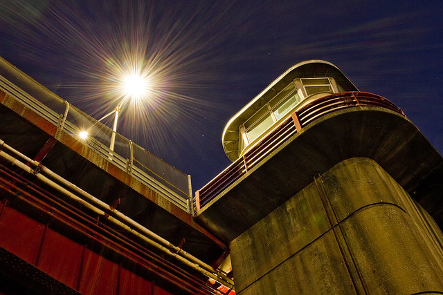
– photo by Mitch Waxman
Looking upwards at the control tower of the Pulaski Bridge from the waters edge, which is what you’re seeing. That’s where the various knobs, dials, buttons, and levers that open and close the thing are found.
These shots were gathered using my “minimal” carry setup (2 light lenses, cable release, air blower, couple of lens cloths, and that Ultrapod camera support gizmo), and I used the cheapo Canon “pancake” 24mm lens which I’ve mentioned in the past for all of them. For a variety of reasons, it doesn’t always work for me to grab the whole kit and kaboodle on my way out of HQ, and I’m also trying to carry a bit less around with me than I usually do at the moment in general. Also, not having zoom lenses and being “mission specific” forces me to think more about the “where” of my shots and there’s also the whole “be intentional” thing.
Also, lest I forget, “Pulaski Bridge” – Casimir Pulaski was a Polish military officer who joined General Washington’s Continental Army of the 13 colonies in order to assist in their war of rebellion against the Hanoverian Throne of England during the Revolutionary War. Google him, interesting person, and a Polish National Hero.
I have to don my monkey suit tonight and head off to the City for a party with the fancy folks on the Hudson side of things. I’ll be carrying the minimum kit again, so let’s see what I can get.
“follow” me on Twitter- @newtownpentacle
Buy a book!
“In the Shadows at Newtown Creek,” an 88 page softcover 8.5×11 magazine format photo book by Mitch Waxman, is now on sale at blurb.com for $30.
apotheosis delayed
Things to do, here in Queens.

– photo by Mitch Waxman
Next week promises to be chock full of interesting meetings with Government employees who already know what it is that they want to do, but are obliged by custom and law to at least feign engaging with the public.
The Bicycle fanatics have lately set their sights on Northern Blvd., and since the New York City Department of Transportation (DOT) seems to be willing to be led like a mewling lapdog by this small but influential group of paid lobbyists and their Twitter mobs, there’s going to be a public meeting discussing traffic, life, death, and bicycles on Northern Blvd. at 6:30 p.m. on the evening of Monday the 22nd of October at PS 151, the Mary D. Carter School, found at 50-05 31st Ave here in Astoria. #carnage
I’ll be there, since what else do have to do? #nolife

– photo by Mitch Waxman
On Tuesday the 23rd of October, the New York State Department of Transportation will be holding a meeting at Sunnyside Community Services, 43-31 39th St, Sunnyside, NY 11104, at 6:00 p.m., to discuss and receive input on the two new parks which they will be constructing in Queens as part of their ongoing Kosciuszcko Bridge replacement project. These two properties in question are found on a section of 43rd street which would have been familiar to depression era Yeshiva students, or modern day customers of the Restaurant Depot company, and sit at the veritable border of Blissville and Maspeth. It’s still quite early in the process, concerning the build out of these two parcels, so they’re looking for community input for the design process and are calling the meeting a “charette.” I’m sure you can just show up, but they’re asking for RSVP’s to this email address. #parkland
Similarly to the NYC DOT event, what else do I have to do, so I’ll be there. #ineedahobby

– photo by Mitch Waxman
Finally, on October 24th at 6 p.m. at LaGuardia Community College’s atrium of Building E (31-10 Thomson Avenue, Long Island City, NY 11101), the NYC Economic Development Corporation will be holding a public meeting to discuss the quixotic dreams of our Mayor to build the Death Star a deck over the Sunnyside Yards. The Dope from Park Slope himself won’t be there, but he’s sending his chief Gentrification Officer and Deputy Mayor, Alicia Glen, to Queens. They’re asking for RSVP’s and claim that the event is already full up, but I’d suggest that anyone who can should show up and let the Manhattan people know what you it is you think of the idea of the City borrowing $18 billion to build a deck over a rail yard in LIC in order to allow a well connected group of campaign donors and real estate developers the chance to exploit an 183 square acre parcel and move 100,000 people onto it. #landgrab
The so called “man of the people” doesn’t want to borrow $18 billion to fix NYCHA, or MTA, or fund any of the “progressive” stuff he claims he’s all about, I’d point out. He’s perfectly happy to saddle the City tax payers with this debt for us to pay off for decades, however, long after he’s gone on to play his (self designated) rightful role as the king of the lefties. #dontdeckqueens
“follow” me on Twitter- @newtownpentacle
meager funds
There does not seem to be a verifiable national food holiday for Oct. 9th, although one checked source suggests that it’s National Moldy Cheese Day.

– photo by Mitch Waxman
A humble narrator, for one, is sick of this summer stuff at this point. One realizes, as my pal Chrissy Remein from Riverkeeper pointed out to me recently, that this global warming thing is getting pretty apparent by this point and that this is the “new normal,” but regardless – I’m tired of the shvitz. I shouldn’t have to leave the house in October dressed as I would be for a July afternoon, and as another friend of mine would opine – “get home with total swamp ass.”
Pictured above is the scene as observed just west of Queens Plaza late on last Saturday afternoon.

– photo by Mitch Waxman
I conducted an LIC tour on Saturday, during which the weather was – as mentioned, “shvitzy and swamp ass” – but as is my habit I arrived at the meetup spot a bit early. Vast clouds of haze were rising from the vicinity of the Queens Midtown Tunnel and so a humble narrator investigated. It would seem that road work crews were installing a new coat of asphalt to east bound toll plaza, which accounted for the misty haze as VOC (volatile organic compound) tainted steam rose from trucks of a superheated industrial waste product (produced by the petroleum industry) which we as a culture mix with concrete and liberally spread about on vehicular roadways.
Those are the work crews pictured above, in DUPBO – Down Under the Pulaski Bridge Onramp.

– photo by Mitch Waxman
The preceding Friday was equally as uncomfortable to be moving through the Newtown Creek industrial zone, with its affection of the so called “Maspeth Heat Island” effect. This environmental condition, named for the area of industrial Maspeth just east of LIC but is similarly experienced along the banks of the entire Newtown Creek, sees ambient temperatures rise 5-15 degrees higher than in surrounding neighborhoods due to the complete absence of vegetation and abundance of concrete. The concrete and masonry walls of factory buildings, sidewalks, and roads all bake in the radiation of the burning thermonuclear eye of God itself and store up energy, becoming radiant sources of heat. It feels a bit like walking about in a kiln, or oven, even on days when the Mercury never rises out of the 70’s. Forget about the sensation encountered when the atmosphere is already in the 90’s early in the morning.
That’s the Hunters Point Yard of the Long Island Railroad pictured above, which is similarly in DUPBO.
Upcoming Tours and events
The Hidden Harbors Of Staten Island Boat Tour,
with Working Harbor Committee – Sunday, October 15th, 2 p.m. – 4 p.m.
A very cool boat tour that visits two of the maritime industrial waterways of New York Harbor which adjoin Staten Island and Bayonne in New Jersey – The Kill Van Kull and the Arthur Kill. There will be lots of tugboats, cargo docks, and you’ll get to see multiple bridges from the water – including the brand new Goethals Bridge. I’ll be on the mike, narrating with WHC board member Gordon Cooper – details here.
“follow” me on Twitter- @newtownpentacle


