Archive for the ‘Roosevelt Avenue’ Category
little polyhedron
Street photography, literally, in today’s post.

– photo by Mitch Waxman
Every little facet of Western Queens is endlessly fascinating to one such as myself. The section of Jackson Avenue which was refashioned into Northern Blvd. in the early 20th century (a puzzling nomenclature, as it runs east/west, and both Ditmars and Astoria Blvd. are further north), which I’ve long referred to as the “Carridor” has a distinctive look and feel. On the western end of it, the Real Estate Industrial Complex has finally broken through the barrier presented by the southern end of 31st street and large scale tower production is under way. It won’t be long before the Manhattan skyline views which Western Queens is known for will be completely obfuscated by the glass boxes being hurled at the sky.
Let’s face it, a used car lot has a huge footprint, and the Real Estate shit flies are rapacious when the subject of Sasquatch property lots arises. Thing is, this used car lot strains the Municipal infrastructure a whole let less than a block of apartments.

– photo by Mitch Waxman
Over on 43rd street, a longish roadway that leads from Newtown Creek to the south to a northern terminus at Bowery Bay and which transverses Astoria, Sunnyside, and Blissville that used to be called Laurel Hill Blvd., there’s a window on the world of tomorrow which can be observed by looking over the Sunnyside Yards at the western horizon. In Tolkien’s epics, it’s the west that the elves disappeared into. Coincidentally, the same mythology is presented as relating to the Decadent Dutch colonials who fled the “English” through Western New York and New Jersey by the literature of Washington Irving, H.P. Lovecraft, and many others. In Western Queens, the Real Estate Industrial Complex has stolen the western sky, as evinced by the shield wall of luxury apartment buildings rising from the filled in swamps of Long Island City pictured above.
Legend has it that the Dutch will return someday, when we need them most, but we won’t see them coming anymore.

– photo by Mitch Waxman
The same shield wall of construction is visible from the eastern side of Skillman Avenue in Sunnyside, which rises from the elluvial flood plains of Newtown Creek’s Dutch Kills tributary nearby Skillman’s intersection with Thomson Avenue. The intersection of two communities is nearby, on a sloping hill which hosts both a “Woodside” and a “Sunnyside.” The Woodside, my reading suggests, was heavily forested with deciduous speciation in its aboriginal state, and the Sunnyside was more of grassland interspersed with coniferous trees that graduated into what would best described as an environment resembling the Louisiana Bayous.
The Sunnyside of the hill sloped down to the swampy lowlands of what’s now Queens Plaza, Dutch Kills (neighborhood), and the Degnon terminal area. This condition, which bred what was contemporaneously described as a “pestilential number of cholera and typhus carrying mosquitoes,” largely persisted in Queens until the early 20th century when the Sunnyside Yards, Degnon Terminal, and Queensboro Bridge construction projects included a fair bit of land reclamation and swamp drainage.
Upcoming tours and events:
“Brooklyn Waterfront – Past & Present” boat tour
with Working Harbor Committee, Thursday, September 15th from 6:00 to 8:00 p.m.
Click here for tickets.
“13 Steps around Dutch Kills” walking tour
with Atlas Obscura, Sunday, September 18th from 11:00 a.m. to 2:00 p.m.
Click here for tickets.
“First Calvary Cemetery” walking tour
with Brooklyn Brainery, Saturday, October 8th from 11:00 a.m. to 1:00 p.m.
Click here for tickets.
“follow” me on Twitter- @newtownpentacle
lay supine
Woodside into Sunnyside, in today’s post.

– photo by Mitch Waxman
Wandering around one recent afternoon, a humble narrator found himself on the always fascinating Roosevelt Avenue. As mentioned in the past, the entire length of Roosevelt Avenue is a challenging spot to gather photographs due to the presence of the elevated tracks of the 7 subway line and the shadows which fall away from it and paint the streets. Combine this with the presence of bright afternoon light, and you’ve got a real pickle in terms of exposure.
One likes a challenge, and the shot above was captured at the spot in Woodside where the 7 meets the Long Island Railroad.

– photo by Mitch Waxman
I was meant to meet up with some folks in Sunnyside, at a pub on Skillman Avenue, at the end of my perambulation. That’s why one found himself staring at this bodega at the top of Skillman’s sloping hill, and a bit of graffiti caught my eye, so I crossed over to the north side of the street to get a better view.

– photo by Mitch Waxman
Just as I got into position, two Latino kids also appeared with their cameras (smartphones, natch) and we started to chat about the whole Trump thing. Personally, I’ve been enjoying watching “The Donald” use the National Republican Party’s well oiled “hate machine” against itself, but let me tell you – these kids were PISSED OFF, and they have every right to be. It’s been a long time since a Presidential candidate ran for office using race baiting as part of his platform – I think the last one might have been Strom Thurmond. We laughed a bit, and made a couple of “You’re Fired” jokes.
One of the kids then asked me how much I paid for my camera, so that’s when I decided it was time to get back on Skillman and go meet up with my chums.
“follow” me on Twitter- @newtownpentacle
Upcoming Tours –
September 20th, 2015
Glittering Realms Walking Tour
with Brooklyn Brainery, click here for details and tickets
simple swains
Most photogenic Subway line nomination, in today’s post.

– photo by Mitch Waxman
The elevated 7 line has become quite famous for its multitudinous delays, entire weekends wherein service is suspended, and the frustrations of the vast population who count on it as their daily conveyance to and from the Shining City from Queens. One would offer that despite all of this, it looks great, and since appearances are all that really matter under the current administration in City Hall and Albany…

– photo by Mitch Waxman
The underground lines just don’t have the same panache as the elevateds, and there are analogs for them in every major human infestation found upon the earth. The subterranean lines are dirty, dark, and the sweating concrete bunkers through which they run are the kingdoms of the rat. The first shot in today’s post emanates from a point in space roughly one hundred or so yards above the one above depicting the E line, incidentally.
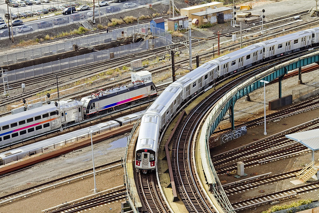
– photo by Mitch Waxman
The 7 even looks good from high above, as it turns out of the Hunters Point stop into the open air over the Sunnyside Yard and heads towards Court Square. If the MTA has a “Belle of the Ball,” it’s clearly the 7 – esthetically speaking. There’s a lot to be said about the scenery at Bushwick junction as well, but the 7…

– photo by Mitch Waxman
Further east, where the so called international express heads through Sunnyside and Woodside and Jackson Heights high over Roosevelt Avenue – towards its eventual destination in Flushing – the 7 carries itself with a certain bearing and sharply appointed charm. One therefore nominates the 7 as the best looking of NYC’s subways.
Remember, it’s better to look good than to feel good, and that form always trumps function.
“follow” me on Twitter- @newtownpentacle
Upcoming Tours –
July 12th, 2015
Glittering Realms Walking Tour
with Newtown Creek Alliance, click here for details and tickets.
richly draped
A few random shots from around Queens, in today’s post.
– photo by Mitch Waxman
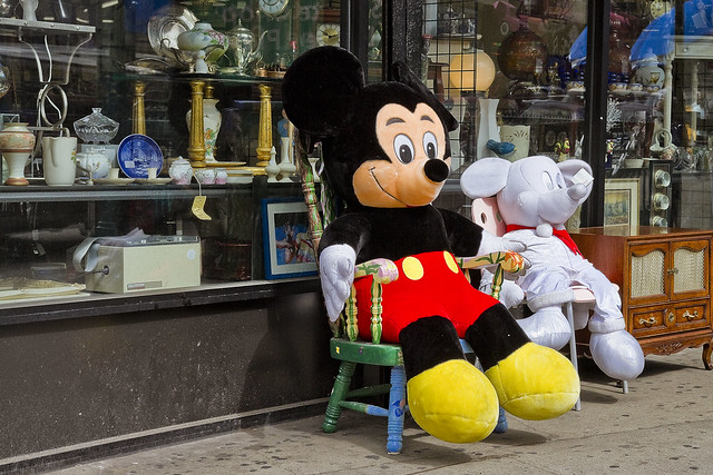
Over on Steinway Street, here in almond eyed Astoria, these iconic representations of the Disney corporation seemed to just be chilling out in front of the Salvation Army thrift store the other day. Not sure what the story is with the ghostly one on the right, maybe it’s the “Mickey of Christmas Past” or some other Dickensian (Mickensian, perhaps) meme.
– photo by Mitch Waxman
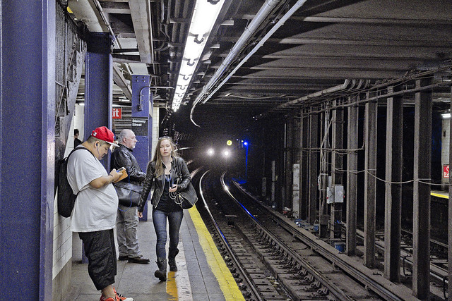
I was heading into the City one day last week, performing my usual exercises with exposure and camera settings while waiting on the Subway platform when I got this shot. Don’t know why, by I just kind of like it. I do wonder what the fellow on the left was listening to on those headphones.
– photo by Mitch Waxman
The angle between Woodside and Sunnyside, as well as the convergence of Greenpoint and Roosevelt Avenues with Queens Blvd., there’s something about this paritcular intersection that one such as myself finds visually interesting. A point is made to pop off a few exposures whenever I’m passing by, which in this case was on my way to visit Second Calvary over in Woodside.
“follow” me on Twitter- @newtownpentacle
Upcoming Tours –
May 16, 2015 –
13 Steps Around Dutch Kills with Atlas Obscura
with Newtown Creek Alliance Historian Mitch Waxman, click here for details and tickets.
May 31, 2015 –
Newtown Creek Boat Tour
with Working Harbor Committee and Newtown Creek Alliance Historian Mitch Waxman, click here for tickets.
nothing now
Twirling, ever twirling.

– photo by Mitch Waxman
The POV at the 40th Lowery Street stop on the 7 train causes my jaw to drop everytime I see it. Given what it costs for acccess to the observation deck at “Top of the Rock” or the Empire State Building, the MTA really delivers value for money – view wise – here on Queens Blvd. Turn your head to the left – you can spy the Kosciuszko Bridge, look straight ahead and its the whole soup bowl of Manhattan, and to the right there’s Hells Gate Bridge. This view is fortuitous, as at least you have some diversion while wondering when the train will arrive.

– photo by Mitch Waxman
This spring, I’m trying to mix things up a bit and do some shooting in parts of Western Queens which aren’t part of my normal “thing.” There’s a bit of tumult going on between my ears at the moment, so the curative – as always – is to just get out and do some photographing in challenging places. To wit, the combination of bright and dark offered by the 7 tracks as they exit Woodside and head towards Jackson Heights along Roosevelt Avenue. Exposing for both lighting conditions is a wicked conumndrum, camera wise, but all of the shooting I’ve been experimenting with in the underground system pays a certain dividend when attempting this sort of thing.

– photo by Mitch Waxman
Roosevelt Avenue is, of course, pretty much antithetical to anyone who desires solitude or quiet. The blasting sound of passing trains that cascades down form the elevated’s steel is monstrous. One thing which always staggers the European University people whom I’ll conduct tours of Newtown Creek or Long Island City for is noise. It seems that the EU is several decades ahead of us in terms of what they legally define as “pollution” and that endemic urban background noise is taken as seriously as bad water or air.
“follow” me on Twitter- @newtownpentacle
Upcoming Tours –
May 3, 2015 –
DUBPO, Down Under the Pulaski Bridge Onramp
with Newtown Creek Alliance Historian Mitch Waxman, a free tour offered as part of Janeswalk 2015, click here for tickets.
May 16, 2015 –
13 Steps Around Dutch Kills with Atlas Obscura
with Newtown Creek Alliance Historian Mitch Waxman, click here for details and tickets.
May 31, 2015 –
Newtown Creek Boat Tour
with Working Harbor Committee and Newtown Creek Alliance Historian Mitch Waxman, click here for tickets.


