Move, move, move
Friday
– photo by Mitch Waxman
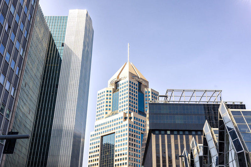
Lots and lots of tasks needed tending, doctors appointments and other boring mundanities. This has seen me driving around greater Pittsburgh a lot and occasionally sticking the camera through the car’s moon roof when I’m waiting at red lights. I cannot wait for the inevitable day that I have to explain this to a cop at a traffic stop. That’s Downtown Pittsburgh pictured above.
I think this was from the first weekend in June. We experienced a couple of really disconcerting things during this interval. My next door neighbor’s house had a structural fire break out, for instance, which I had a front row seat for. 5 engine companies showed up to put it out. Other insalubrious stuff has happened too, but that’s life in the not so big City, huh?

– photo by Mitch Waxman
Another errand of mine involved bringing the Mobile Oppression Platform into the local Toyota dealership for its 5,000 mile servicing dealie. They rotate the tires and measure the various juices, and plug in a diagnostic device to run some kind of software checks on the various systems under the hood. Warranty maintenance stuff, basically, which is something I need to contractually oblige. It took about 90 minutes and then I was out.
While cooling my heels for the hour and a half, the verticality of the opposite side of the street caught my eye. I think that house is in Beechview, but I’m kind of guessing. I gotta say, if I owned a property here with a yard that had a slope like that, I’d pay whatever I had to for some landscape terracing. Flat areas. Then again, if I do end up owning property at some point, my first priority will be planning and building the boobie traps and kill alleys. That means I’m going to have a long conversation with the Postal and Amazon guys, of course. I’m also going to want to own the mineral rights of the under lands. Coal, yo.

– photo by Mitch Waxman
Pictured above, in the Pittsburgh Borough of Dormont where HQ can be found, is about how bad the Canadian wildfire smoke got for us. It wasn’t anything like what y’all on the East Coast experienced.
!!! HEY, THAT’S THE FIRST TIME I’VE GOTTEN TO SAY THAT! A disaster happened in NYC and I wasn’t in the middle of it! WOW.
Really… Get out while you still can.
“follow” me on Twitter- @newtownpentacle
Buy a book!
“In the Shadows at Newtown Creek,” an 88 page softcover 8.5×11 magazine format photo book by Mitch Waxman, is now on sale at blurb.com for $30.
Getting there
Thursday
– photo by Mitch Waxman
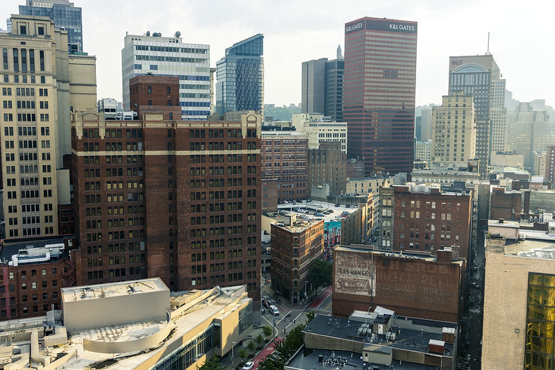
As mentioned yesterday, my buddy was doing an appearance at a comic convention in Downtown Pittsburgh. He’s a bit of a star, and the convention organizers put him up in a hotel for the show. The shot above is the view from a hotel room window on its twenty something’s floor.
Our Lady of the Pentacle and myself joined him and his spouse for dinner and drinks, leaving the car back home in Dormont so that a humble narrator could imbibe. We took the T Light Rail into town, and called for a cab afterwards.

– photo by Mitch Waxman
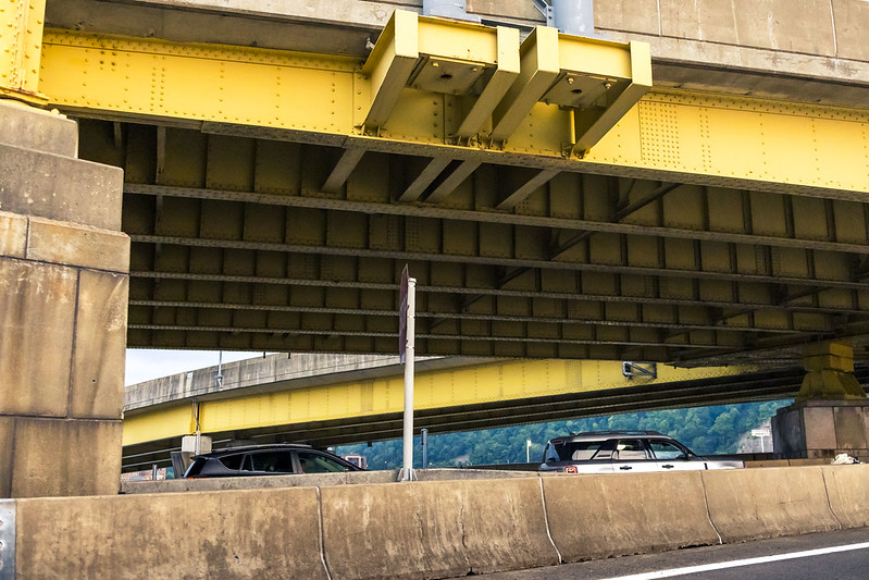
It’s been a while since someone else was doing the driving for me here in Pittsburgh, so I took the opportunity of being in a ride share LYFT car to shoot pix out of the open window on our way home afterwards. The sun sets a bit later hereabouts than it did back home. It’s weird seeing it light out at 9 p.m., but there you go.
I’m absolutely fascinated by the web of off and on ramps here in Pittsburgh, which had been mentioned in the past. All of those curvilinear massing shapes…
– photo by Mitch Waxman
One realizes that he’s likely the only person on earth who sees a high speed road and says ‘ooh, look at them parabolas,’ but that’s me. I’m like the Kiwi – a fuzzy little fruit with a lot of personality and quirks.
As always, back tomorrow.
“follow” me on Twitter- @newtownpentacle
Buy a book!
“In the Shadows at Newtown Creek,” an 88 page softcover 8.5×11 magazine format photo book by Mitch Waxman, is now on sale at blurb.com for $30.
Convention Center fountains
Wednesday
– photo by Mitch Waxman
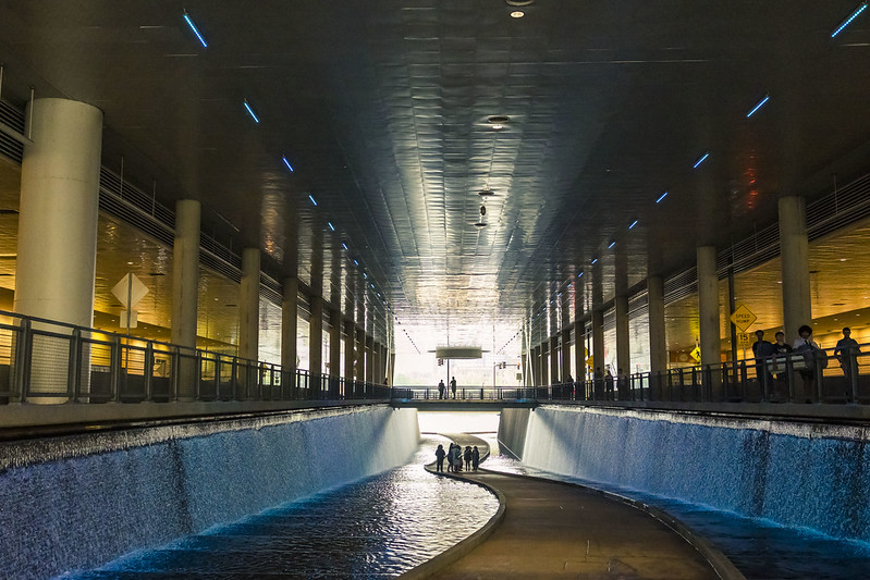
A buddy of mine is a very successful comic book artist, and he was in Pittsburgh recently as one of the invited ‘marquis name’ guests at a Comic Convention which was held at the Pittsburgh Convention Center which is found in the downtown area.
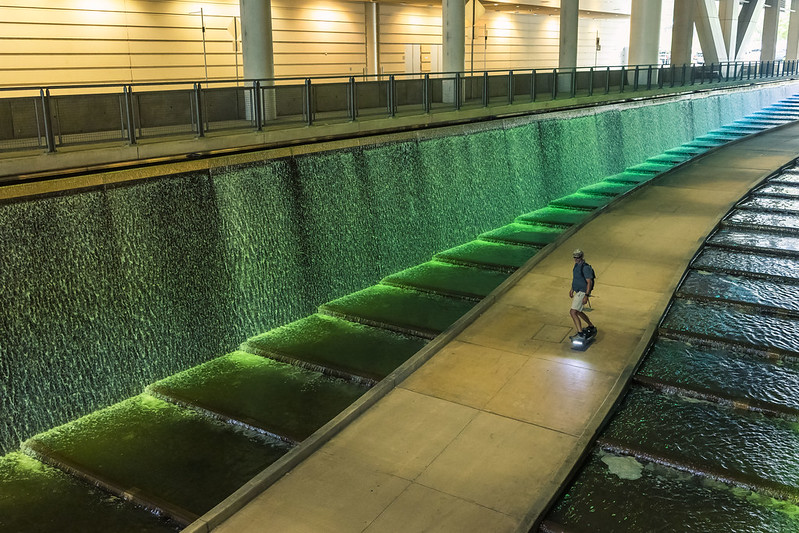
I’ve mentioned the convention center in the past as being an interesting bit of architecture, and even noted the tunnel that sits in the middle of its two halls which allows public egress to the Allegheny River and the bike and pedestrian trail found along its banks. Saying that, I had never seen what it looked like when they turned on the fountains at the Convention Center. Wow.

– photo by Mitch Waxman
The water cascades down out of some recessed area, and there’s lighting which cycles through a few different colors, and which is positively nice. I couldn’t help but snap out a few shots, and make a mental note to come back here sometime soon with the whole kit to gather some artsy fartsy filter shots of the thing.
This was really neat. On either side of the tunnel, up on the level which I was standing on, there’s pick up and drop off lanes for automobile traffic, and foot bridges across the tunnel for pedestrians to get from one side of the facility to the other. Neat!
– photo by Mitch Waxman
Unlike the Javitz center in NYC, where Andrew Cuomo established a mass casualty hospital ward during COVID, the convention center here in Pittsburgh is a functional entity and is popularly attended. A can of Coca Cola does not cost $7 within it. It’s also not a glass island found in a ragged no man’s land at the edge of the City far from transit.
It’s got pretty fountains, too.
“follow” me on Twitter- @newtownpentacle
Buy a book!
“In the Shadows at Newtown Creek,” an 88 page softcover 8.5×11 magazine format photo book by Mitch Waxman, is now on sale at blurb.com for $30.
Seldom Seen Greenway, addendum
Tuesday

– photo by Mitch Waxman
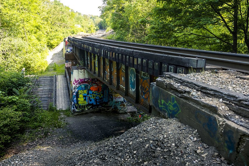
Yesterday, I described the ‘Seldom Seen Greenway’ trail in Pittsburgh’s Beechview section, and mentioned that there was a second level to the place found above the brick lined trestle pictured above. This second level, as I discovered, hosts active rail tracks. I found that out while doing a bit of research on the place after getting back to HQ from the location.
That’s why I found myself back there a day or two later. I had to take a look at what, where, why, how – all that.
– photo by Mitch Waxman
It wasn’t that difficult getting all the way up here, but it was a bit complicated getting back down the steep incline while managing my camera and pack. These are freight tracks, ones which are somewhat infrequently used – once or twice a day, I reckon. I’ve seen video of trains moving along the tracks here, which display the polished steel rails you’d associate with active RR tracks. A Wheeling and Lake Erie train set was moving through in the video I saw, but I couldn’t tell you if this is exclusively their right of way or not.
I hung around up there for about a half hour with my fingers crossed, but then I got bored and slid back down the steep hill to the greenway below. I’ll be back, next time with a sandwich and thermos bottle of water, and just wait it out. Trains are a lot like fishing.

– photo by Mitch Waxman
I shot a few shots down below, with nothing terribly special to show for the effort, frankly. The nearby Saw Mill Run Boulevard, named for this waterway, is a primary arterial roadway that connects to the Liberty Tunnel on one side and the West End Bridge (amongst other destinations in either direction) on the other. It also connects to two other primary arterials called Banksville Road and West Liberty Avenue. These three roadways have secondary and tertiary high volume roads that branch off and lead out into the residential neighborhoods of the South Hills in this part of Pittsburgh.
Back tomorrow with something different at this, your Newtown Pentacle.
“follow” me on Twitter- @newtownpentacle
Buy a book!
“In the Shadows at Newtown Creek,” an 88 page softcover 8.5×11 magazine format photo book by Mitch Waxman, is now on sale at blurb.com for $30.
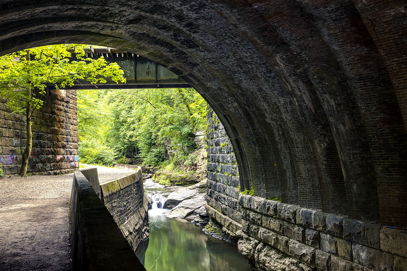
Seldom Seen Greenway
Monday
– photo by Mitch Waxman
About a 15 minute drive from HQ in Pittsburgh’s Borough of Dormont is the neighboring South Hills community of Beechview. Along a very busy arterial roadway called Saw Mill Run Boulevard is found a 3/4 of a mile long trail called ‘Seldom Seen Greenway.’ A recent visit was paid.
There’s a rail trestle at the entrance, and the pathway in from the parking area follows the flowing waters of the Saw Mill Run waterway. Based on olfactory observation, Saw Mill Run receives a bit of wastewater flow from the surrounding residential areas.

– photo by Mitch Waxman
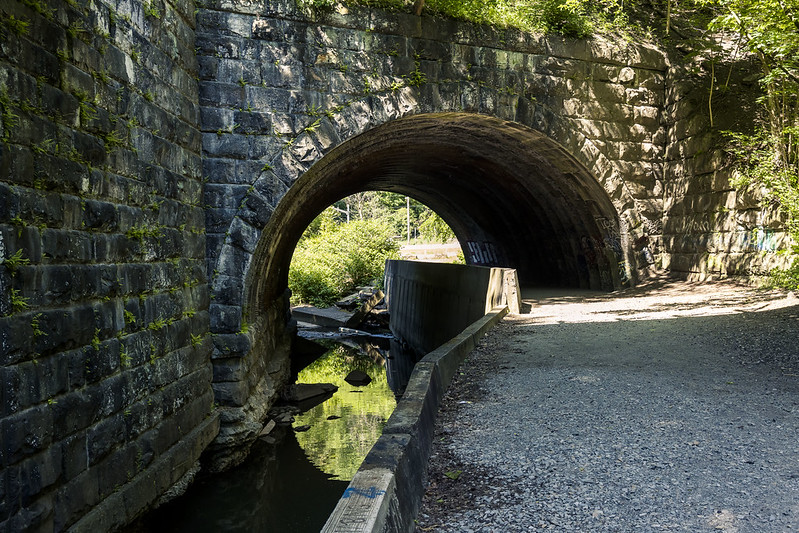
The rail trestle at the entrance has a finely wrought brick tunnel, which is something that kind of jumps out at you. A lot of time and effort went into the masonry, and given that what you’d normally encounter in a spot like this would be unadorned concrete, it makes me wonder why the expense was undertaken to create this sort of fascia.
The entire path is graded. Pavement is present. It seems there’s a group who looks after the place, but this is an ‘official’ public place and recreational path.

– photo by Mitch Waxman
There’s opportunity to get down to the water from the path, although in many places that opportunity is either quite steep or obstacles like patches of Poison Ivy occlude one’s intentions to do so. The sloping hillsides leading down to Saw Mill Run are fully wooded.
The waterway itself is largely shallow and only a few inches deep, but there’s a couple of spots where the bottom drops away to a few feet and the water flows quickly across the gaps. My guess is that if you were a teenager in Beechview, this is one of the places where you would go to escape parental or adult oversight and smoke the devil’s cabbage.
– photo by Mitch Waxman
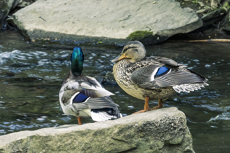
Every time I try to say what kind of a bird a bird is, I just get it wrong so instead I make up names for the Avians. Thusly, your looking at a Nine Fingered Radish Hen in the shot above.
I actually do know that’s a duck, so you don’t need to tell me that. What kind of a duck? Ask an Audubon, Bro.

– photo by Mitch Waxman
Above the trestle at the entrance there are two other levels of rail infrastructure. After returning to HQ and poking around on the internet, I discovered that the top level tracks are still active. On this first visit though, I didn’t climb up there to investigate.
I’m actually quite pleased to have found this place, so close to HQ. This will be a great spot to take short walks when time is short. There’s also a dedicated ‘Seldom Seen’ parking lot, so double win. As you’ll discover at the end of this post, I’m now seriously in need of this sort of place.
– photo by Mitch Waxman
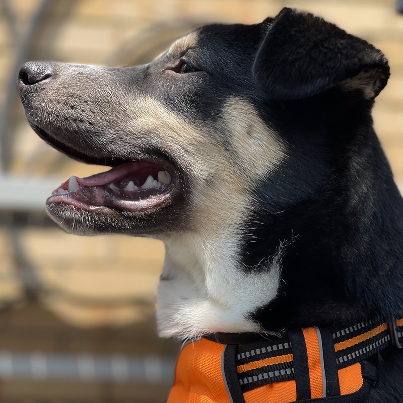
I’m going to require a portfolio of spots like this one, after all. Near the house, separated from traffic and distractions. There’s lots of training underway here in Dormont. What kind of training, you ask?
Meet the newest member of the family: Moe the Dog. He’s 5 months old, and whereas he only weighs about 35 pounds, he’s nevertheless a ton of fun. That’s my new Pennsyldoggie.
“follow” me on Twitter- @newtownpentacle
Buy a book!
“In the Shadows at Newtown Creek,” an 88 page softcover 8.5×11 magazine format photo book by Mitch Waxman, is now on sale at blurb.com for $30.


