Posts Tagged ‘Blissville’
odours occasionally
DUGABO, or Down Under the Greenpoint Avenue Bridge Onramp, in today’s post.

– photo by Mitch Waxman
In yesterday’s post, we explored the darkened streets of industrial Blissville along Railroad Avenue to the west of the Greenpoint Avenue Bridge. Today, we head eastwards along this seldom examined lane. That car with the headlights on was a private security guard that was vouchsafing the various industrial locations in DUGABO, but since I was wearing my construction worker high visibility vest of invisibility over the filthy black raincoat, he just waved at me and drove away.
Under normal daylight circumstance, wherein the vest is not worn, private security would normally hassle one such as myself. “What’s you takins pickchas of” and “whose youse workins for” are the usual queries.

– photo by Mitch Waxman
The concrete block fenceline to the right of the shot guards a parcel currently occupied by the NY Paving Company, who maintain a large fleet of construction vehicles therein. It’s part of the former home of the Van Iderstine rendering company, mention of which usually sends a shudder up the spine of any longtime resident of Greenpoint or Blissville. The railroad tracks on the left side of the shot are the LIRR’s Lower Montauk branch.
Van Iderstine was, and is, a rendering company (they moved to Newark about 20 years ago). Van Iderstine boils down organic material (spoiled meat, rotten eggs, butchers blood, animal bones) in pursuit of manufacturing tallow and agricultural fertilizers. The way they do it nowadays is fairly innocuous compared to the manner which the historical record talks about here in Blissville.

– photo by Mitch Waxman
A private waste carting company hosts a smallish facility next door to NY Paving, one of the several waste transfer stations found along Railroad Avenue here in Blissville. There are a few street lamps on this side of the bridge, unlike the western side detailed in yesterday’s post. The good news is that it’s the “old school” sodium lamps here, rather than the bluish hued LED ones. I miss the oranges.
Van Iderstine’s had a contract with the City stipulating that if any large animal (horses, oxen, even circus elephants) were to die in the city limits, it would be sent to them for processing. Their grinders had a special rig to handle the elephants.

– photo by Mitch Waxman
Until recently, Railroad Avenue terminated a few hundred feet from the spot where this shot was captured, a somewhat private road and cul de sac. That all changed when the City’s Solid Waste Management plan came into effect. The Waste Management Corporation built a facility down here to handle putrescent or black bag garbage, and then cut a new and unnamed road through the former Van Iderstine properties which connects to Review Avenue opposite First Calvary Cemetery.
The industrial scene in this section of Blissville has always been somewhat macabre, and disgusting to modern tastes. Yeast distilleries, swill milk dairies, bone blackers, slaughterhouses, neet oil manufacturers – all part of the historic story around these parts. When the petroleum people began to arrive in the late 19th century, it was considered a godsend as they were displacing the former lessees who took their stinks with them.

– photo by Mitch Waxman
Also demanded by the Solid Waste Managment plan, a so called “Green Asphalt” plant was created here (as well as other places). When the City regrades or just digs out a street, the asphalt they scrape up might be brought to Blissville and recycled. They accomplish this by heating the stuff up and mixing it with fresh materials, and on humid days during the summer you can smell the scent of asphalt cooking all over Blissville, Laurel Hill, and the north side of Greenpoint.
Still better than Van Iderstine’s, longtime residents of both communities will tell you.

– photo by Mitch Waxman
Waste Management has two waste transfer stations along Newtown Creek, the other is in East Williamsburg/Bushwick along the English Kills tributary of Newtown Creek. The one in Blissville is the smaller of the two, but they both accomplish the task of handling the black bag garbage collected by the Department of Sanitation. Waste Management packages the collections up in those green box cars you see in the shot above, which form up the garbage train.
Like Green Asphalt, on hot summer days, you can smell this facility from almost a mile away. I’m told that the Van Iderstine works, and the old Manhattan Adhesives company glue factory (in the Miller Building on the Brooklyn side), were worse. Lord only knows what sort of poison there is lurking in the ground.
So, Mr. Mayor, back to that homeless shelter you want to place less than a half mile from here…
“follow” me on Twitter- @newtownpentacle
perceptibly when
DUGABO at night, in today’s post.

– photo by Mitch Waxman
The reliable Greenpoint Avenue Bridge is a double bascule drawbridge which spans the Newtown Creek, connecting the Greenpoint section of Brooklyn with the Blissville section of Queens. Heavily travelled, there are two access roads alongside the bridge which lead down to the aptly named Railroad Avenue. This is the latest Greenpoint Avenue, or John J. Byrne memorial, Bridge. The 1900 vintage bridge which the modern version replaced was just to the west of the modern span, sat in the footprint of the access road in the shot above, and it carried railroad tracks. There have been five Greenpoint Avenue Bridges, this is the 1987 model which is a renovated version of GPA Bridge #4. It’s 1.37 miles up the creek from the East River, and opens a few times a day to allow tugboats and oil barges egress.
The 1850’s original was called the Blissville Bridge, and it was made of wood.

– photo by Mitch Waxman
Railroad Avenue is the very definition of what I often refer to as “the concrete devastations of Western Queens.” Formerly, this area was remarkable for the presence of the Tidewater Pipeline company (a Standard Oil subsidiary) and the Buckeye Pipeline. In recent years, the Broadway Stages company has been buying up property along the bulkheads in pursuance of creating TV and movie filming locations. Their desire to maintain the “real” and “gritty” side of LIC for theatrical usage has accidentally turned the company into building preservationists.
If the area looks familiar to you, you’ve likely seen it in some of the Marvel Netflix productions like “Punisher” or “Daredevil” that were filmed down here. Every cop show in NYC has done a scene hereabouts as well.

– photo by Mitch Waxman
If you follow Railroad Avenue to its western terminus, you encounter the Sims Metal recycling works. Sims has been mentioned too many times to count at this – your Newtown Pentacle – so I’d ask you to just type “Sims” into the search box at upper right of this page to check them out. Suffice to say that in addition to handling all sorts of scrap metal and junk cars, Sims Metal also enjoys a municipal contract with the City of New York which sees them handling the metal/glass/paper curbside recycling program (blue and clear bags) that the Department of Sanitation operates.
If you were here during during the work week or in the daylight hours, on Railroad Avenue in Blissville, there would be dozens and dozens of heavy trucks and DSNY vehicles idling while waiting for their chance to tip out their collections at Sims. All of these trucks transit through Blissville, some come twice a day.

– photo by Mitch Waxman
The Blissville Yard of the Long Island Railroad is an MTA owned facility. Up until the 1990’s, there was regular passenger service along these tracks, which are known as the Lower Montauk.
Today – the name of the game on the Lower Montauk is freight, and the Blissville Yard is used to build the up the linked box cars of the garbage train, six days a week. In tomorrow’s post, I’ll show you the other side of Railroad Avenue, where the black bag or putrescent garbage goes for processing, and loading, into these green box cars.
As a note, the shots being presented in today’s post are all long exposures. Railroad Avenue literally has no street lights, and it’s only ambient glow from the industrial lots surrounding it illuminating things.
Figuring that somebody would ask, in between the tripod shots I cracked out a handheld one that accurately depicted something closer to what the naked eye can see down here at night – this one.

– photo by Mitch Waxman
These oil tanks are now part of the Broadway Stages properties portfolio, but they were once known as the Lukoil/Getty dock. The signage on the fence indicates that the pipe you see in the lower left hand corner is a now inactive valve for the Buckeye Pipeline. The building in the distance is the former Tidewater facility that juts up against the bulkheads of Newtown Creek.
Getty is one of the family of oil companies (a subsidiary of Mobil, I believe) which were initially named in the 2010 Superfund decision by the EPA. More recently, Sims Metal and the Long Island Railroad have been added to the list of “potentially responsible parties.” The City of New York itself is one of the bad guys, too.

– photo by Mitch Waxman
That’s the western side of Railroad Avenue, here in Blissville’s DUGABO (Down Under the Greenpoint Avenue Bridge Onramp), for you. Waste Transfer stations, fading oil infrastructure, movie and TV sets, no street lights or sidewalks. Tomorrow, I’ll show you the eastern side of DUGABO.
Your first thought, just like the Mayor, must be that it would be ideal to site a gargantuan homeless shelter nearby, right? What could go wrong with that idea?
“follow” me on Twitter- @newtownpentacle
thunderous declamations
Instead of Iowa or Texas, the Mayor ought to come out to Queens once in while, just in the name of “Equity.”

– photo by Mitch Waxman
The Long Island Expressway rises out of the Queens Midtown Tunnel in the Hunters Point section of Long Island City, and follows the route of Borden Avenue on a high flying steel truss which is at its height 106 feet over the waters of the Dutch Kills tributary of Newtown Creek. According to the NYC DOT’s 2015 numbers, this section of “495” is called the Queens Midtown Expressway and it carries nearly 85,000 vehicle trips a day. It comes back to ground at the border of the Sunnyside and Blissville sections of Long Island City, at Greenpoint Avenue.
That’s about 31 million vehicle trips a year rolling through LIC, and in particular – Blissville. The shot above represents exactly thirty seconds worth of traffic on a corner one block away from the entrance/exit to the LIE. Thirty seconds… keep that number in mind when looking at the shots in today’s post. They’re all thirty second exposures.

– photo by Mitch Waxman
That’s the LIE itself, shot from the access road which feeds down onto Borden Avenue in an area I call the “Empty Corridor.” I was down there just a couple of weeks back, and the zone was discussed in this post. For the sake of trivia – the LIE opened on the 15th of November in 1940.
The northern border of Blissville is formed by the Long Island Expressway and the Empty Corridor. Saying that, if you’re on the north side of the LIE, you’re still in Sunnsyide.

– photo by Mitch Waxman
On the Blissville side, rivers of steel flow past you on the local street/access road modernity calls Borden Avenue. Named for where it was going, namely the Borden Dairy farm in Maspeth, Borden Avenue was created as a wooden plank road in 1868 that connected the western end of the road with the East River shoreline, and with the upland agricultural properties to the east. Originally, this raised roadway – designed for mules and oxen pulling milk wagons – crossed through the malarial swamps surrounding Dutch Kills.
By the early 20th century, the swamps had been drained or filled in, and Borden Avenue was paved with belgian block and later macadam and asphalt. It became an industrial corridor whose path more or less mimicked that of the Long Island Railroad’s Lower Montauk Branch tracks found just to south, along the bulkheads of the Newtown Creek.

– photo by Mitch Waxman
To the east of Borden Avenue is Greenpoint Avenue, which was built into its current path in 1852 from a dirt road. On one side of the street, since 1848 at least, First Calvary Cemetery will be found. When it opened, Calvary wasn’t even half the size it is now. Acquiring property through inheritances and purchases, the cemetery didn’t attain its current borders until the early 20th century, just before the First World War. There are literally millions held in the loam.
Blissville itself is named for one of its founders, Greenpoint’s Neziah Bliss. It was developed with Eliaphet Nott of Union College, and the goal was creating one of those utopian worker’s hamlets which were all the rage amongst wealthy Protestant industrialists in the years leading up to the American Civil War. There were meant to be no bars or saloons in Blissville, but in the 1850’s when the railroad began to be driven through, the Irish laborers working on the iron road put an end to all that. Additionally, the masses of people coming to Calvary from the Five Points and Lower East Side to visit the graves of loved ones created a demand for inns and bars.
Blissville was one of the five communities which seceded from the Newtown Municipality to form Long Island City in 1870.

– photo by Mitch Waxman
According to a 2015 report from the NYC DOT, the Greenpoint Avenue (aka John J. Byrne memorial bridge) Bridge carries 28,361 vehicle trips across Newtown Creek on a daily basis. That’s 10,351,765 vehicles a year heading to and from Brooklyn’s Greenpoint to Queens’ Blissville. The traffic feeding through Blissville is (observationally) going in three main directions once it enters Queens; a) north on Greenpoint Avenue towards the LIE and Sunnyside, b) north west on Van Dam towards Queens Plaza, and c) east on Review Avenue towards Maspeth and Middle Village.
The second largest oil spill in the United States is the Greenpoint Oil Spill, the epicenter of which is less than half a mile east on the Brooklyn side of the Greenpoint Avenue Bridge. Similarly, an oil spill of still unknown size lurks in the soil of Blissville less than half a mile east of the Greenpoint Avenue Bridge. The bridge itself crosses the Newtown Creek, a Federal Superfund site notorious for the 1.8 billion gallons of raw sewage which the NYC DEP dumps into it annually.

– photo by Mitch Waxman
According to the Blissvillians whom I’ve met, the population of this neighborhood is around 220 people although I’ve also heard 500 (seems a bit high, 500). It’s the usual demographic mix of Queens hereabouts, but with the proviso that almost everybody would describe themselves as “working class.” There’s a generational community here which has held out in the post industrial landscape of Long Island City – despite the traffic and the pollution and the industrial character of the neighborhood. All told, about 4-6 blocks square blocks are the totality of Blissville, Queens. The nearest subway is on Queens Blvd. in Sunnyside, and the two bus lines running the area are in service on neither a twenty four hour nor seven days a week schedule. There are no schools, hospitals, or supermarkets. There are a lot of City owned properties, warehouses, and waste transfer stations.
Mayor Bill de Blasio’s Department of Homeless Services, therefore, has decided that this is the ideal and “appropriate site” for a third homeless shelter (within a half mile of the LIE) to be opened in the neighborhood. This time around, it will be the 2008 vintage and 154 room Fairfeld Inn, found at 52-34 Van Dam Street, that becomes a shelter. Blissville anticipates some 400 people will be installed in this building. Another Hotel on the Sunnyside side of the LIE has been converted to a shelter, as has a former Public School on Greenpoint Avenue.
Blissville could use your help with all this trouble the Mayor is sending their way, Queensicans. A Department of Homeless Services public hearing will take place on Thursday the 15th of March at 6:30 p.m., at St. Raphael’s Church located at 35-20 Greenpoint Ave.
Let’s tell the Manhattan people what the Ides of March are like in Queens, and let the Dope from Park Slope know that enough is enough.
“follow” me on Twitter- @newtownpentacle
rolled down
Down with the night, yo.

– photo by Mitch Waxman
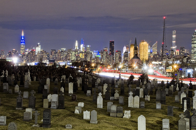
As opined yesterday, the wrought iron fence posts of First Calvary Cemetery are just the right size to stick a camera lens through. In that prior post wherein my keen observational prowess was offered, focus was given to the estimable Kosciuszcko Bridge project, while today’s set of images are a few night shots of the cemetery itself. Unless you are an absolute fanatical maniac on the subject of eating carrots or half Kryptonian, these shots are just a smidge broader than the perceptual range of human vision. The light sources are environmental, incidentally.
All I saw, with the naked eye as it were, was a silhouette of the cemetery against the skyline of the Shining City to the west.

– photo by Mitch Waxman
There were a few examples of the long exposures one returned to HQ with, wherein the camera’s sensitivity to light was enhanced in different ways, which rendered out as sort of cartoonish, and overexposed the lit up Manhattan skyline into a white blob. Saying that, I was able to reclaim an excruciating amount of detail from the shadowed areas but the images were in “the uncanny valley,” meaning that they looked utterly fake and overtly “digital.”
You can’t put a landscape picture of Calvary Cemetery up on the web without some recognizable part of the skyline in it, as a note.

– photo by Mitch Waxman
On Laurel Hill Blvd., here at the angle between Industrial Maspeth and Blissville, however – if you “go wide” the section of Manhattan between the Battery and 57th street can all be captured in one shot.
“follow” me on Twitter- @newtownpentacle
no prophet
Back in the dark, in Blissville.

– photo by Mitch Waxman
Last week, Newtown Creek Alliance organized an event in Ridgewood at a local pub which was both a “meet and greet” and an informational event. After it ended, my pal Hank the Elevator Guy offered me a ride towards Astoria in his automobile, but I asked for and instead received a quick lift over to DUKBO.
Hank the Elevator Guy was concerned for my safety, and asked if I was armed. I was, with a camera and tripod. What are you kidding, it’s Newtown Creek – that’s my house. The Kosciuszcko Bridge beckoned, so I headed over to Laurel Hill Blvd. alongside First Calvary Cemetery and got busy with the clicking and the whirring.

– photo by Mitch Waxman
The NYS DOT and their contractors are using a pretty good chunk of Laurel Hill Blvd. to store or park construction equipment, and the spot you’re looking at above used to be pretty much where the 1939 K-Bridge stood until it was demolished last year. One attended a meeting with officials from the agency not too long ago, and they indicated that the second phase of the project was on schedule and we’d be seeing both steel and concrete starting to rise out of the site this summer.
They say that everything should be wrapping up in the next 24 months or so.

– photo by Mitch Waxman
One sort of lingered about in the area, as I wasn’t being molested or eyeballed by private security. My plan, as you’ll discern from the shots in today’s post, was to accomplish the latest in a series of long exposure shots I’ve been creating all winter. Also, the climate was comfortable, atmospherically speaking.
Also, in that meeting with the NYS DOT, the head of the project indicated that the footbridge connecting 43rd street on Sunnyside’s southern extant with Blissville’s Laurel Hill Blvd. was not only completely rebuilt but was open for business. Additionally, a style of fencing inspired by the wrought iron of the cemetery fence had been installed on the structure, ideal for sticking a camera lens through, unlike the original model which was clad in chain link.

– photo by Mitch Waxman
The things I was told turned out to be true, and one enjoyed not just the opportunity to gain a bit of elevation over the deck but to also see the new bridge from a different set of angles than have been available for the last couple of years. This shot looks south over the redesigned approach ramp – connecting the Long Island Expressway off ramp to the Brooklyn Queens Expressway onramp, the latter being the road that the K-Bridge carries across Newtown Creek.
– photo by Mitch Waxman
Speaking of the LIE, that’s what it looks like from the pedestrian ramp/overpass that they’ve just built. The old structure was clad in chain link fencing, and despite there being a couple of “Bernie Holes,” here and there – POV options were always limited up here.
For those not in the know, a “Bernie Hole” is a gap in chain link fencing which was opened sometime in the 1980’s or 90’s by my departed pal Bernie Ente. There’s still a few of them around the Creek, and I’m pretty much the only one he ever entrusted the location of most of them to. “Gotta get your shot,” he would opine.

– photo by Mitch Waxman
Crossing under the LIE overpass from Blissville into Sunnyside, a humble narrator did one last setup with the tripod and associated gear. I call areas like this “The House of Moses” after Robert Moses, who slammed his roads through neighborhoods and cemeteries all over New York City and in particular Western Queens.
“follow” me on Twitter- @newtownpentacle


