Posts Tagged ‘Circumavigation of Staten Island’
corresponding sign
Cool stuff I get to do, in today’s post.

– photo by Mitch Waxman
As far as the fellow pictured above, I’d normally reference Captain America, but in the case of Thomas Asbery it’s Colonel America. Col. Asbery is the commandant of West Point and heads up the United States Army Corps of Engineers in the NYC region. He’s an immensely nice and friendly guy, and last Wednesday was the second time that I got invited out on his boat with a bunch of other activists, officials, and water facing people to do a harbor inspection. Last year, we went out to Jamaica Bay so that the Colonel and his staff could show off some of the shoreline resiliency projects they were working on. This year, we headed off in a different direction – for a circumnavigation of Staten Island.
A number of post Hurricane Sandy USACE shoreline projects which have been planned in the interim are about to start playing out in Richmond County, and which are designed to protect upland neighborhoods and businesses from future storms, and also to prepare NYC – proactively – for rising sea levels in the 21st century. Whatever your politics are on the subject of climate change are is immaterial to the engineers and soldiers of the USACE – they have a job to do and that’s protecting the citizenry.

– photo by Mitch Waxman
About a hundred of us gathered on the west side of lower Manhattan, a couple of blocks away from the World Trade Center site. We boarded the vessel pictured above, the DCV Hayward. A drift collection vessel, Hayward is one of several boats operated by the USACE that performs maintenance functions in NY Harbor. You can read a bit more about her mission and function here.
If you didn’t click through, Hayward and it’s crew remove flotsam and jetsam and any other navigational hazards which might interfere with maritime traffic from the water. Hence the big crane.

– photo by Mitch Waxman
Hayward first navigated eastwards and then moved in a southern direction along the coast of Brooklyn for a bit, then began the southwest journey towards Staten Island. Along the way, Col. Asbery and his staff told the assembled guests about various efforts they were involved in executing, and we were treated to the usual variety show that NY Harbor offers.
It was medium early in the morning – or late afternoon by military or maritime standard – we left the dock at 9 a.m. There were articulated tug and barge combos everywhere, as well as standard harbor tugs performing various duties.

– photo by Mitch Waxman
That’s the tug Shawn Miller, towing a flat top barge that had two semi tractor trailer trucks on it, as well as a statue of a horse festooned with “Longines” logos. Doesn’t matter if the tug is pulling, pushing, or tied up “on the hip,” it’s called towing.
Tug companies in NY Harbor generally name their boats after family members. The tug pictured above is owned by a family owned company. Obviously, the family surname is Miller.

– photo by Mitch Waxman
Hayward navigated into the section of the Narrows between Brooklyn’s Bay Ridge and Staten Island. Gerritsen Bay is the official nomenclature for this section of the water, and our course carried us directly under the Verrazano Narrows Bridge. Notice the low lying shoreline above?
The section of Staten Island between the Bridge and the Arthur Kill were amongst the most heavily flooded sections of the City during Sandy, back in 2012, and the USACE has designed a plan to keep that from happening again. The beaches along Father Cappodano Blvd. on this coast are going to completely redone, we were told, with a sloping sandy berm and a Rockaway Beach style boardwalk designed to structurally support it. Most of the drowning deaths associated with the storm occurred in the neighborhoods (Arrochar, South Beach, Ocean Breeze, Midland Beach, and New Dorp Beach) found along this shoreline.

– photo by Mitch Waxman
Photographically speaking the shoreline mentioned above is fairly “meh,” as it’s a residential and wooded area. A humble narrator began to perk up when the Hayward entered the maritime channel on the western shoreline of Staten Island known simply as the Arthur Kill. That’s the Port Authority’s Outerbridge Crossing bridge pictured above.
More tomorrow, at this – your Newtown Pentacle.
“follow” me on Twitter- @newtownpentacle
Buy a book!
“In the Shadows at Newtown Creek,” an 88 page softcover 8.5×11 magazine format photo book by Mitch Waxman, is now on sale at blurb.com for $30.
unthinkable hands
Adventure and excitement.
– photo by Mitch Waxman
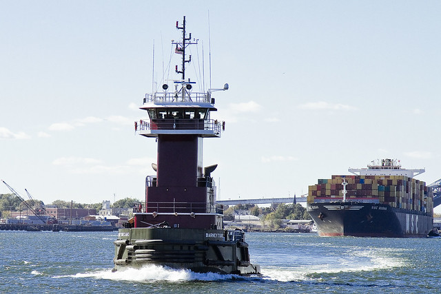
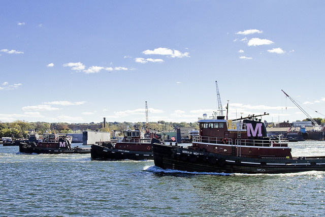
Working Harbor Committee’s annual Circumnavigation of Staten Island tour carried me out onto the Kill Van Kull recently, and despite it being a Sunday, the waterway was teeming with busy tugs. Moran, in particular, was quite occupied.
Pictured above is the Barney Turecamo.
– photo by Mitch Waxman
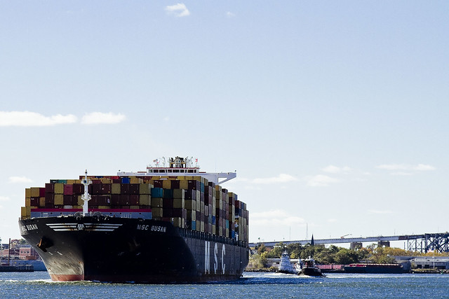
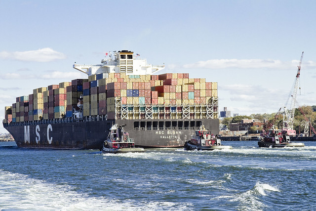
The tugs were accompanying MSC Busan, a cargo ship, from Port Elizabeth Newark to the outer harbor along the narrow and busy Kill Van Kull.
– photo by Mitch Waxman
Barney Turecamo was leading the way, and bringing up the rear were Miriam Moran, Gramma Lee T. Moran, and Laura K. Moran. All the Moran tugs have painted their “M” pink to raise awareness for Breast Cancer research.
– photo by Mitch Waxman
By cargo ship standards, MSC Busan isn’t that big a boat. Built in Korea in 2005, flagged in Liberia, she’s 324,80 meters long and can carry 8089 TEU worth of containers. TEU means “ton equivalent unit” and the cargo containers you see onboard are either 20 or 40 TEU boxes, which the boat can carry 6275 of.
“follow” me on Twitter- @newtownpentacle
Upcoming Walking Tours-
Saturday, November 8th, Poison Cauldron
Walking Tour with Atlas Obscura, click here for tickets and more info.
Note: This is the last Newtown Creek walking tour of 2014, and probably the last time this tour will be presented in its current form due to the Kosciuszko Bridge construction project.


