Archive for the ‘Verrazano Narrows Bridge’ Category
Archives #034
Thursday

– photo by Mitch Waxman
Our Lady of the Pentacle and myself lived in Astoria for about nineteen years and I think that I walked over the Pulaski Bridge between LIC and Greenpoint at least once a week for about fifteen of those years. I christened the surrounding area as DUPBO – Down Under the Pulaski Bridge Onramp. It seems many of the mouth breathers from Maspeth take umbrage at this, but I really don’t care.
Over the years, the Maspeth crowd always disappointed me, regarding Newtown Creek. The general sentiment there is to pave it over.
2018’s ‘professional duty’ wandered around ‘DUPBO’ in Long Island City.

– photo by Mitch Waxman
The part of Brooklyn I grew up in is practically not in the same Borough as Williamsburg/Greenpoint. My Dad went to Automotive for high school, I’d mention, and back when I was a teenager – if the subject of either neighborhood came up – he’d say ‘Stay outah Nort Brooklyn.’
Long story short, I was a Good Humor Man for most of a summer at the end of high school, and my ice cream selling partner and I ended up getting into a high speed (30mph, as these trucks are not quick) ice cream truck chase with Mister Softee on the Belt Parkway (starting all the way out by Kings Plaza), which ended in Williamsburg when our truck’s engine conked out. Softee escaped the wrath for poaching our territory.
Needing a ride back home from Williamsburg, I called the old man, waking him up. I told him the tale and when I mentioned where we were, he slammed the phone receiver down. Back then, you could hear the phone’s bell chime ring just before the signal went out. A half hour later, the old man shows up in the 1963 Buick Skylark, and me and my partner get in the car. I turn to thank the old man, and then get popped on the side of my head as he said ‘I toldja to stay outah Nort Brooklyn.’
Other than an Italian bakery on Grand street, which made particularly lovely cookies, he avoided the area like the plague. He would have really been pissed off if he was alive when I was doing the whole Newtown Creek thing.
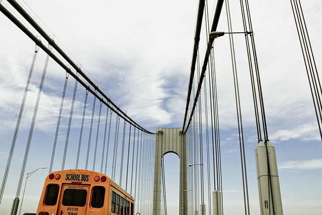
2019’s ‘thing depicted’ focused in on the Verrazano Bridge. This was about the halfway point in the ice cream truck chase.

– photo by Mitch Waxman
I’m not sure what my ‘long walk’ possibilities are going to be, for a while. I might have to buy a bike or something. All of these trails I’ve been walking here in Pittsburgh are bikes too, so… I guess it would be nice to have some range as well – distance here in Pittsburgh is very, very different than it is in New York with its feature rich environment.
These archive posts are reaching into Newtown Pentacle’s backups, and are pulling posts that went public on this date, in their respective years, going back to 2009. This practice will continue until I’m back on both feet full time, and new photos and stories can be gathered. For anyone who hasn’t heard the news, I broke my left ankle at the end of September.
In 2023, ‘low to high’ was published, which discusses a section of a somewhat long walk in Pittsburgh. I got to see a train!
Back tomorrow.
“follow” me on Twitter- @newtownpentacle
Buy a book!
“In the Shadows at Newtown Creek,” an 88 page softcover 8.5×11 magazine format photo book by Mitch Waxman, is now on sale at blurb.com for $30.
emotional need
Thursday

– photo by Mitch Waxman
Sentimental reminiscing is on the menu for me these days, as we head into what is going to be my last summer in New York City. I’ve been here my entire life, and every single corner of the City that I’ve inhabited for the last half century just bleeds with memories of times good and bad.
The best of the urban mythologies from the old neighborhood revolved around the supposed corpses of construction workers, who were killed during construction of the Verrazzano Bridge, whose corpses sunk into the still liquid concrete never to be seen again. This is an urban myth, by the way. The structural integrity of the bridge’s footings would be compromised by the voids created by those bodies.

– photo by Mitch Waxman
The Rockaway Ferry gives you a pretty cool set of views of Coney Island on the way. That’s the Steeplechase Park section. Coney’s were a smallish representative of the rabbit family endemic to the area when the English speaking Europeans arrived, and that’s where the name “Coney Island” comes from. Most of the large scale apartment buildings were constructed by Gambino adjacent real estate powers like Fred Trump and the Waubassie Brothers (I’m probably spelling the second name wrong, btw.)
Coney Island meant a lot to my depression era parents, but back in the 1980’s it was synonymous with hookers and crack and crime for my generation. The Russians arriving here, and in Brighton Beach, back in the 1990’s changed the place, and some of the old veneer has returned to Coney, but underneath the surface there’s still a lot of weirdness waiting to boil over in these parts.

– photo by Mitch Waxman
Wonder Wheel and the Cyclone roller coaster are what most think of when they mention Coney Island, along with Nathan’s Hot Dogs.
It goes to show how ossified the culture of NYC has become in recent decades, that the “cultural show pieces” all date back to a century or more ago.

– photo by Mitch Waxman
Along the way, you get a good view of Queens’ Breezy Point and how thoroughly doomed this part of the City is once the waters begin to rise in the next twenty to thirty years. No flood insurance for you, and “managed retreat” is a phrase to start getting used to.
Really, a big part of why I’m leaving NYC is a conviction that it’s time to start moving away from the Atlantic Coast.

– photo by Mitch Waxman
That’s the other bridge on Flatbush Avenue, the Gil Hodges Marine Parkway Bridge. On the Brooklyn side, it leads to the part of Brooklyn I’m from – the Canarsie, Flatlands, Mill Basin area. The Queens side let’s you make a right and go to the gated community of Breezy Point, or go straight towards Riis Park, or make a left and head over to Rockaway, Far Rockaway, or even Long Beach.
The NYC Ferry dock isn’t too far away from this bridge, about 15 minutes or so.

– photo by Mitch Waxman
I don’t see that everyday, an A train traveling along the waterfront, so I took a picture. Lasts longer.
More tomorrow.
“follow” me on Twitter- @newtownpentacle
Buy a book!
“In the Shadows at Newtown Creek,” an 88 page softcover 8.5×11 magazine format photo book by Mitch Waxman, is now on sale at blurb.com for $30.
thing depicted
Happy Birthday Verrazzano-Narrows Bridge!

– photo by Mitch Waxman
One will not assert that the Verrazzano is in fact a giant cage designed to contain a Lenape earth monster submerged in NY Harbor. Instead, the focus is on the engineering achievements of Othmar Amman and the organizational prowess of Robert Moses – the two fellas who are primarily responsible for the Verrazzano opening on November 21, 1964.

– photo by Mitch Waxman
A humble narrator will avoid rattling on about how in just five years Moses’ crews of more than 12,000 laborers constructed the thing, nor about its various statistics and cyclopean size. One will mention that the 228 feet of clearance over high water offered by the Verrazzano Narrows Bridge is the governing height used by maritime engineers for how high to build all sorts of shipping. Sooner or later, every ship on the planet will theoretically enter NY Harbor, and the Verrazzano is the gatekeeper.

– photo by Mitch Waxman
The only mistake in this fairly sublime structure’s design was the omission of a mass transit trackway between Brooklyn and Staten Island, in my opinion. The upper deck opened on this day in 1964, but the lower roadway was still under construction and wouldn’t be available for use until June 28 of 1969.

– photo by Mitch Waxman
My pal Kevin Walsh of Forgotten-NY, whose childhood in Brooklyn’s Bay Ridge section was framed by construction of the Verrazzano, gave a talk last night at the Bay Ridge Historical Society about the span. I wasn’t able to attend, but I’ve also been privileged to receive his remembrances about the thing in person.

– photo by Mitch Waxman
It seems that the towers of the Verrazzano are fairly infested with nesting Peregrine Falcons, so it can rightfully be referred to as an aerie. Down below, on the water, it’s a maritime superhighway, as the Ambrose Channel leads commercial shipping into NY Harbor towards Port Elizabeth Newark under the bridge. Suffice to say that a significant number of sensors and scanners are secreted and secured to the span, searching for various security threats which might be carried in to the inner harbor on these ships.
Friends in the maritime industrial world have opined, regarding these devices and technologies which they can’t talk about, that “it’s like Star Trek.”

– photo by Mitch Waxman
Today marks 55 years for the Verrazzano. As far as the “mythological” senses shattering behemoth that the Lenape whispered of as being “the grandfather of turtles,” which the Verrazzano’s great weight keeps locked in a primeval prison, the less said the better.
There are also things dwelling in the waters on the… Staten Island… side of the narrows which we must not ever talk about, lest they arise.
“follow” me on Twitter- @newtownpentacle
Buy a book!
Limited Time 25% off sale – use code “gifts25” at checkout.
“In the Shadows at Newtown Creek,” an 88 page softcover 8.5×11 magazine format photo book by Mitch Waxman, is now on sale at blurb.com for $30.
corresponding sign
Cool stuff I get to do, in today’s post.

– photo by Mitch Waxman
As far as the fellow pictured above, I’d normally reference Captain America, but in the case of Thomas Asbery it’s Colonel America. Col. Asbery is the commandant of West Point and heads up the United States Army Corps of Engineers in the NYC region. He’s an immensely nice and friendly guy, and last Wednesday was the second time that I got invited out on his boat with a bunch of other activists, officials, and water facing people to do a harbor inspection. Last year, we went out to Jamaica Bay so that the Colonel and his staff could show off some of the shoreline resiliency projects they were working on. This year, we headed off in a different direction – for a circumnavigation of Staten Island.
A number of post Hurricane Sandy USACE shoreline projects which have been planned in the interim are about to start playing out in Richmond County, and which are designed to protect upland neighborhoods and businesses from future storms, and also to prepare NYC – proactively – for rising sea levels in the 21st century. Whatever your politics are on the subject of climate change are is immaterial to the engineers and soldiers of the USACE – they have a job to do and that’s protecting the citizenry.

– photo by Mitch Waxman
About a hundred of us gathered on the west side of lower Manhattan, a couple of blocks away from the World Trade Center site. We boarded the vessel pictured above, the DCV Hayward. A drift collection vessel, Hayward is one of several boats operated by the USACE that performs maintenance functions in NY Harbor. You can read a bit more about her mission and function here.
If you didn’t click through, Hayward and it’s crew remove flotsam and jetsam and any other navigational hazards which might interfere with maritime traffic from the water. Hence the big crane.

– photo by Mitch Waxman
Hayward first navigated eastwards and then moved in a southern direction along the coast of Brooklyn for a bit, then began the southwest journey towards Staten Island. Along the way, Col. Asbery and his staff told the assembled guests about various efforts they were involved in executing, and we were treated to the usual variety show that NY Harbor offers.
It was medium early in the morning – or late afternoon by military or maritime standard – we left the dock at 9 a.m. There were articulated tug and barge combos everywhere, as well as standard harbor tugs performing various duties.

– photo by Mitch Waxman
That’s the tug Shawn Miller, towing a flat top barge that had two semi tractor trailer trucks on it, as well as a statue of a horse festooned with “Longines” logos. Doesn’t matter if the tug is pulling, pushing, or tied up “on the hip,” it’s called towing.
Tug companies in NY Harbor generally name their boats after family members. The tug pictured above is owned by a family owned company. Obviously, the family surname is Miller.

– photo by Mitch Waxman
Hayward navigated into the section of the Narrows between Brooklyn’s Bay Ridge and Staten Island. Gerritsen Bay is the official nomenclature for this section of the water, and our course carried us directly under the Verrazano Narrows Bridge. Notice the low lying shoreline above?
The section of Staten Island between the Bridge and the Arthur Kill were amongst the most heavily flooded sections of the City during Sandy, back in 2012, and the USACE has designed a plan to keep that from happening again. The beaches along Father Cappodano Blvd. on this coast are going to completely redone, we were told, with a sloping sandy berm and a Rockaway Beach style boardwalk designed to structurally support it. Most of the drowning deaths associated with the storm occurred in the neighborhoods (Arrochar, South Beach, Ocean Breeze, Midland Beach, and New Dorp Beach) found along this shoreline.

– photo by Mitch Waxman
Photographically speaking the shoreline mentioned above is fairly “meh,” as it’s a residential and wooded area. A humble narrator began to perk up when the Hayward entered the maritime channel on the western shoreline of Staten Island known simply as the Arthur Kill. That’s the Port Authority’s Outerbridge Crossing bridge pictured above.
More tomorrow, at this – your Newtown Pentacle.
“follow” me on Twitter- @newtownpentacle
Buy a book!
“In the Shadows at Newtown Creek,” an 88 page softcover 8.5×11 magazine format photo book by Mitch Waxman, is now on sale at blurb.com for $30.
no business
It’s National Pasta Day, in these United States.

– photo by Mitch Waxman
Before I offer a conspiracy theory in today’s post, lets instead start with a bit of NY Harbor trivia – the height of all ships doing business within the Port of New York and New Jersey is governed by the height of the Verrazano Bridge’s span, as relative to the water. All cargo, military, and cruise ships which can be anticipated to someday enter NY harbor are actually designed with the Verrazano’s height in mind.
That means, ultimately, that this last exemplar of the House of Robert Moses erected in 1964, which sets a maximum height limit of exactly 228 feet over the water (at high tide), controls the design of a good chunk of the planet’s shipping fleets (although you’d be scraping the Verrazano’s deck at 228′ so they build them a bit shorter). A somewhat contemporaneous counterpart to the Verrazano is the Puente de las Américas (Bridge of the Americas) over the Panama Canal, which also plays a major role in the design of maritime vessels, setting a height limit of 201 feet over high water for any and all vessels using the crossing. The other approach to the Port of New York and New Jersey is governed by the Goethals Bridge over the Arthur Kill, which offers 135 feet of clearance, just to be entirely anal retentive about things.

– photo by Mitch Waxman
Verrazano Bridge is startlingly enormous, with a main span over the narrows stretching out for nearly a mile at 4,260 feet. Engineer Othmar Amman always liked to point out that his team had to take the curvature of the Earth itself into account when designing and placing the towers, which are off parallel to each other by 1.625 inches. When you add in the approaches on either side to the bridge, the entire thing is some 13,700 feet in length – roughly 2.6 miles. It’s now the 11th largest suspension bridge in the world, and the longest found on either American continent.
There are 143,000 miles of wire incorporated into its cables, enough to wrap around the earth’ equator 5.74 times or stretch half way to the moon. Its towers are 649.68 feet tall, making them the tallest structures outside of Manhattan in all of New York City. It carries nearly 190,000 vehicle trips a day, 69.35 million annually. The best estimates I’ve been able to find suggest that the combined steel of the bridge weighs some 1,265,000 tons.

– photo by Mitch Waxman
The Verrazano Bridge, due to its position and height, is affected by weather more heavily than any other span in New York Harbor. The roadway will actually sag down about a dozen feet during the summer months due to heat expansion, and the winds one encounter on the upper roadway preclude any discussion of pedestrian or bicycle paths being established. One can personally report that while driving over the thing during storms, my automobile was being rocked from side to side by heavy gusts of wind. The bridge is owned and operated by the MTA Bridges and Tunnels division, which is what Governor Nelson Rockefeller turned Robert Moses’s old Triborough Bridge and Tunnel Authority into.
The people at Bridges and Tunnels have a set of rules and customs governing the bridge during harsh weather conditions, which all depend on whether or not the roadways are wet or not, and whether the winds are either sustained or gusting. Speed restrictions begin to apply at 30 mph sustained winds and wet roads, while wet conditions coupled with sustained wind over 40 mph might trigger restrictions on crossings by motorcycles, mini buses, tractor trailers and other types of vehicles.

– photo by Mitch Waxman
I’ve noticed, over the years, that all of NYC’s bridges are possessed of a certain and unique to the span harmonic. Partially, it’s how the structure of the bridge interacts environmentally and also because of the sound of the vehicles running over it cause a vibration as their tires spin against the decks. To my hearing, the Verrazano makes a “wmmm-mmm-mhoooooosh-shhh” sound, but that could just be the particular interaction with the roadway of the vehicles which a humble narrator crosses the thing within, which have always been passenger cars. It’s efficacious to close your windows on the bridge no matter what, lest a torrent of air suddenly swirl into the passenger cabin, causing disarray and a tumult. I’ll leave it to musicians to tell you what key the Verazzano Bridge is in.
Like all MTA Bridges and Tunnel crossings, certain types of vehicles are forbidden. These types of vehicles (amongst others) include steam rollers, vehicles loaded with unconfined animals or poultry, wheelbarrows, and velocipedes.
Yes, they specifically mention velocipedes in the rules.
– photo by Mitch Waxman
I’ve always thought, with the born and raised in Brooklyn perspective that I am possessed by, that the bridge is actually some sort of giant shackle forcing the former City of Richmond or… Staten Island… not to secede from the City of Greater New York and join up with New Jersey instead. A mass exodus of Brooklynites, including my own parents, occurred during the late 1980’s and 90’s to Staten Island over the thing. Most of them, to quote my Dad, were “sick of this shit, and wanted to get the ‘eff out of here,” referring to the colloquialized “old neighborhood” which was “better back then.” I still don’t believe the old adage about being able to leave your door unlocked at night. Rent was a bit cheaper on Staten Island however, my parents perception of crime was far lower, and the semi suburban lifestyle encountered on Staten Island appealed to them in their retirement and dotage. They were also one step closer to Atlantic City where they liked to go on weekends away.
Staten Island is “car country,” unlike the city center neighborhood of Astoria, Queens where I now live. Mass transit (other than the ferry, I mean) exists but… you kind of need to have a car on Staten Island.

– photo by Mitch Waxman
Now for the conspiracy theory: A humble narrator is an idiot, of course, and has always cherished a personal theory that Robert Moses knew something more about NYC than he was letting on. Famously, before beginning his government career, Moses wandered the countryside on foot. Robert Caro suggests that even at a young age, he was planning highways and parks. Pffft… who does that at an early age? Moses was monster hunting, obviously, and he must have found something terrifying during his wanderings. I mean… c’mon… that’s fairly obvious, right?
Why else would he have built a steel and concrete cage around New York Harbor? Would old Bob Moses really have gone out of his way to destroy the coastal wetlands, swamps, and tidal marshes (which are precisely the sort of places you’d find monsters like “Grendels Mother” lurking) of New York Harbor for no reason other than malice? After conquering the human/fish hybrids at Hells Gate with his mighty Triborough, he set about the process of creating the world’s biggest padlock here in the narrows to close the door on his monstrous gate.

– photo by Mitch Waxman
Who can guess, all there is, that might be imprisoned down there beneath the 1,265,000 tons of steel? Is the arterial highway and bridge crossing system of New York City actually some sort of great barrier designed to keep slime dripping colossi in check? Is there some dark secret which will be held forever unknowable and immobile by the Verazzano Bridge?
What hidden and occult knowledge did Robert Moses take to the grave with him?
“follow” me on Twitter- @newtownpentacle


