Posts Tagged ‘Dutch Kills’
from some point in space

– photo by Mitch Waxman
Recent travels and travails, which I’ll be describing in some detail in the coming days, have been consuming me. Antiquarian studies, which normally bring joy and excitement to one such as myself, are instead feeding a black dog nipping at my heels. The arrival of seasonally appropriate cold weather shatters the illusion I project of vigor and health, and instead reveals a weakened and tired old man whose ease of movement and comfort is shattered by lower temperatures. A huddled mass of insulating garments, what you perceive as a windblown pile of rag and filth often reveals itself to be me.
I’m all ‘effed up.
from nytimes.com
The Roswell P. Flower estate sold last week to the Borden Realty Company, a subsidiary concern of the Degnon Terminal Improvement Company, 362 lots in the sunken meadows south of Jackson Avenue, in Long Island City, and extending to Dutch Kills Creek and Newtown Creek, at prices ranging, it is said, from $1,000 to $1,500 each.
The Degnon Terminal Company has already invested from $2,500,000 to $3,000,000 in Long Island City meadows and meadows at the head of Flushing Bay, in the towns of Flushing and Newtown.
The meadows are to be filled in with the earth taken from the Belmont tunnel, and the Dutch kills Canal and Flushing Bay are to be dredged.

– photo by Mitch Waxman
Recent opportunities and accesses to certain locations normally forbidden to the general public have drawn me out from HQ, however, and that which I have witnessed is the terrible spectacular of those sky flung monoliths and hybrid pestilences which typify the City of Greater New York in these dawning years of the 21st century. Gaze in despair upon the waste meadows of Dutch Kills, from high above.
from trainsarefun.com
Just south of Sunnyside Yards is Degnon Terminal, operated by the Degnon Realty & Terminal Improvement Company. A subsidiary, Degnon Terminal Railroad Corporation operated a switching terminal. It received and delivered cars from and to connections and switched them to the various industries, also the reverse operation. This carrier’s only railroad connection was with the Montauk Cutoff of the Long Island Rail Road at Pearson Street [Hunterspoint Avenue], Long Island City. Degnon constructed its tracks about 1919, although land reclamation and grading began about 1907.

– photo by Mitch Waxman
My vantage was from within the cyclopean Degnon Terminal, a once mighty industrial center and railhead which has been transmogrified into a community college. The occasion which brought me here will be explored in later postings, but since the ennui under which your humble narrator currently suffers precludes any notion of positive thought, it was decided to just display these images for your consideration and not engage in some some long winded and depressing monolog about it.
from nydesigns.org
The NYDesigns staff know that summer’s truly over when, after two introspective weeks in a silent fructarian monastery in Appalachia, we spy the godzilla-sized, tomato-red IDCNY sign halfway through the 7-minute walk from the trains at Courthouse Square. We share the building with LaGuardia College CUNY and E. Gluck Corporation, a watch manufacturing company.
In 1908, however, the “Thousand Window Bakery,” a best practice factory showcase for the Loose-Wiles Biscuit company originally of Kansas City was the building’s sole tenant. All 10 stories of the building housed production, sales and management as well as 2500 employees in a Fabian, sun-infused proletarian paradise, complete with a lending library and a clubhouse. Trading under the name Sunshine Biscuits, the cookies were baked in the shape of Popeye, Olive, Swee’pea, Wimpy, etc. and distributed in tin boxes which are now modestly priced collectibles. Animal crackers originated here. Now a subsidiary of Keebler, Sunshine is now best known for producing the Cheez-It brand of snack crackers.
The “Thousand Window Bakery” was one piece within the larger industrial park of Degnon Terminal, the brainchild of Michael Degnon, entrepreneur and railyard contractor for the Sunnyside Yards, which abut the building’s northwestern facade. Degnon Terminal was attractive to companies including the Packard Auto Company, Ever Ready, and Chicle (of Chiclets gum) because of the ease in shipping just-manufactured goods via rail straight to distributors.The Sunnyside rail lines haven’t seen any traffic since 1989 and the industrial occupants have long moved on to more affordable real estate climes. Sunshine left in the mid ’60s.

– photo by Mitch Waxman
The water you see in the center of these photographs is the logical end of Dutch Kills, a tributary of the oft maligned Newtown Creek. The first bridge you see is the Hunter’s Point Avenue Bridge, which nears its 100th year of service to the municipality in uncommented anonymity (not if I have anything to say about that), and the large white structure is the Queens Midtown Expressway section of the Long Island Expressway which hurtles high over the empty corridor of long Island City.
Beyond is infinite Brooklyn, with the Newtown Creek Wastewater Treatment Facility just left of center in centuried Greenpoint.
from nyc.gov
Long Island City is comprised of five separate neighborhoods: Ravenswood, Astoria, Steinway, Sunnyside, and Hunter’s Point. Engine Company No. 258 is located on 47th Street in Hunter’s Point, about halfway between Newtown Creek and the Queensboro Bridge. Though someearly nineteenth-century legal documents refer to the area as Long Island Farms or Long Island City, it was not until the 1850s that the current name was widely used. Popularized by a local newspaper, the Long Island Star, when the five villages were incorporated as an independent municipality in 1870, the neighborhood was officially named. Hunter’s Point became the commercial and political center of the new city, served by the Long Island Railroad at 2nd Street, near the East River, and multiple ferries to Manhattan. The seat of Queens County moved here from Jamaica, and two years later, in 1872, the New York Supreme Court Building for Queens County (reconstructed 1904-8, a designated New York City Landmark) was built on Jackson Avenue, now called Court Square. Long Island City grew quickly and the population tripled between 1875 and 1900. Among the various houses built in the area, a fine group survives on 45th Avenue, between 21st and 23rd Streets, in the Hunter’s Point Historic District. Faced in brick, brownstone, and Tuckahoe marble, these Italianate, Second Empire,and Neo-Grec structures, were collectively known as “White Collar Row.” Hunter’s Point had nearly 18,000 residents in 1905, a number that has never been exceeded.
Queens became a borough of Greater New York in 1898 and Long Island City became theseat of the borough president, with offices in the Hackett Building (c. 1885) on Jackson Avenue until 1916. Various transit projects that proved critical to real estate development in Queens were completed during this period, including the opening of the Queensboro Bridge (1909, a designated New York City Landmark), tunnels linking Manhattan with the vast Sunnyside Yards (1910), and the beginning of regular IRT subway service (1915) to Corona, and later, Flushing. Access to the general area was greatly improved, attracting large factories and warehouses that benefited from spur lines that allowed freight cars to travel directly to the loading docks. Various examples can be found in the Degnon Terminal area, along Thomson Avenue, where the Adams Chewing Gum and Loose Wiles Sunshine Biscuit companies located in the 1910s. These improvements, however, had a downside, creating barriers that isolated Hunter’s Point from the rest of the borough, while making it easier for commuters to reach new residential districts to the east, in Sunnyside, Jackson Heights, and other neighborhoods.
Superfund me

– photo by Mitch Waxman
LO, BEHOLD, and TREMBLE… for the Newtown Pentacle is back in session…
Over several of the last few years, agents and officials of the Federal Government have conducted a strange and secretive investigation into certain conditions within and around the ancient New York waterway called the Newtown Creek.
The public first learned of it in 2009, when a vast series of public meetings and pronouncements were offered by agents of the Environmental Protection Agency which confirmed and introduced the news that the ancient corridor of industry and forbidden history called the Newtown Creek was being considered for inclusion on the Federal Superfund list.
This listing would bestow extraordinary powers over the waterway, and ultimate authority, to the Federal Government. Effectively, the 3.8 mile long border of Brooklyn and Queens with its enormous number of crumbling bulkheads, worm eaten piers, and supposedly empty warehouses are now the responsibility of the G-Men. Uninquiring souls let the occurrence pass as one of the major developments in a spasmodic war on environmental pollution and the toxic legacy of the industrial revolution.
from epa.gov
Release date: 09/27/2010
Contact Information: John Senn (212) 637-3667, senn.john@epa.gov
(New York, N.Y.) The U.S. Environmental Protection Agency (EPA) today added Newtown Creek in New York City to its Superfund National Priorities List of the country’s most hazardous waste sites. The final listing will allow EPA to conduct a comprehensive evaluation of the creek to determine what remedial actions need to be implemented. Various sediment and surface water samples have been taken along the creek. Potentially harmful contaminants such as pesticides, metals and polychlorinated biphenyls (PCBs) have been detected in Newtown Creek along with volatile organic compounds (VOCs). VOCs are potentially harmful contaminants that can easily evaporate into the air.
“The toxic pollution in Newtown Creek is more than a century in the making. EPA is placing Newtown Creek on the Superfund list to ensure the creek receives a thorough cleanup,” said EPA Regional Administrator Judith Enck. “Newtown Creek is a key urban waterway, which provides recreational and economic resources to many communities. Throughout the investigation and cleanup, we will work closely with the communities along the creek to achieve a revitalization of this heavily-contaminated urban waterway.”
EPA proposed Newtown Creek be added to the Superfund NPL list in September 2009. EPA received and considered public comments on its proposal before making its final decision.

– photo by Mitch Waxman
On Monday the 27th of September in this year of 2010, the EPA announced the Superfund listing of Newtown Creek would be moving forward.
Interesting coincidences abound for this date:
The first Ford Model T rolled off the assembly line in 1908 in Detroit, Einstein had his E=MC2 formula published for the first time in 1905, Crete fell to the Turks in 1669, and the Jesuits were granted a Papal charter in 1540. The Warren Commission released its report on the assassination of President John F. Kennedy in 1964, the Ottoman Siege of Vienna began in 1529, the Taliban captured Kabul in 1996, and Thomas Nast was born in 1840.
It is also 110 years and 19 days after this report appeared in the NY Times, and some 122 years and 11 days since this report appeared in the same publication.
also from epa.gov
EPA had previously responded to requests by members of Congress to evaluate specific sites along Newtown Creek by publishing a September 2007 report that contained a review of past and ongoing work being conducted to address the Greenpoint oil spill as well as recommendations regarding future work to assist with the spill response. The state of New York referred the site to EPA due to the complex nature of the contamination in the creek. EPA’s Superfund study and cleanup are expected to focus on the sediments in the creek and on identifying and addressing sources of pollution that continue to contribute to the contamination.
Newtown Creek is part of the core area of the New York-New Jersey Harbor Estuary, which has been designated by EPA as an “estuary of national significance.” Despite the ongoing pollution problems, some residents currently use the creek for recreational purposes such as kayaking, while others eat the fish they catch from the creek.

– photo by Mitch Waxman
According to statements rendered by Government representatives, the actual work on the remediation project is not scheduled to begin in earnest for several months (if not years), as a period of further study and evaluation of the endemic situation before the final formulation of their plans to ferret out and eradicate all that there is which may be buried down there.
The government plans on removing hundreds of metric tons of the sediment which lines the bottom of the Newtown Creek. Privileged to have been included on the conference call during which EPA announced their decision to the third estate, your humble narrator queried EPA personnel as to the methodology of its removal (terrestrial industries versus maritime) and whether they had determined a probable destination for the contaminant laced material they intend to dredge out.
Both questions seemed to have been unexpected, and they reported that answers will be readily uncovered when the final action plan is unveiled sometime in the near future.
additionally, from epa.gov
In the mid -1800s, the area adjacent to the 3.8-mile Newtown Creek was one of the busiest hubs of industrial activity in New York City. More than 50 industrial facilities were located along its banks, including oil refineries, petrochemical plants, fertilizer and glue factories, sawmills, and lumber and coal yards. The creek was crowded with commercial vessels, including large boats bringing in raw materials and fuel and taking out oil, chemicals and metals. In addition to the industrial pollution that resulted from all of this activity, the city began dumping raw sewage directly into the water in 1856. During World War II, the creek was one of the busiest ports in the nation. Some factories and facilities still operate along it, and various adjacent contaminated sites have contributed to its contamination. Today, as a result of its industrial history, including countless spills, Newtown Creek is badly polluted.
In the early 1990s, New York State declared that Newtown Creek was not meeting water quality standards under the Clean Water Act. Since then, a number of government-sponsored cleanups of the creek have taken place. The New York City Department of Environmental Protection has sampled sediment and surface water at a number of locations along the creek since 1980. In early 2009, EPA sampled the sediment throughout the length of Newtown Creek and its tributaries. EPA will review existing information about Newtown Creek to develop a plan for further investigation.

– photo by Mitch Waxman
The professional press also on the call seemed more interested in the Gowanus Canal, how the Mayor felt about the announcement, and grew fixated on the cost of the cleanup effort. EPA clearly spelt out that its budgeting process has barely begun, and they can neither supply a final cost estimate or time table at this early date. This is actually the logical course, as the secrets of the Newtown Creek must- as always- bubble up and reveal themselves to those who stare deeply into its occluded depths.
And, in their own time, all the poisons in the mud will leach out.
and also, from epa.gov
EPA conducted an Expanded Site Investigation (ESI) of Newtown Creek in 2009 as part of the Hazard Ranking System scoring process for NPL listing under Superfund. Based on the ESI, which was focused on Newtown Creek itself and not its tributaries, EPA concluded that metals, volatile organic compounds, and semi-volatile organic compounds (including polycyclic aromatic hydrocarbons and polychlorinated biphenyls) were present in Creek sediments at elevated concentrations. The variety and distribution of the detected contaminants suggests that they originated from a variety of sources. Previous environmental investigations of Newtown Creek, or specific portions of the Creek, also disclosed that sediments in Newtown Creek are contaminated by a wide variety of hazardous substances. Environmental investigations of upland parcels adjacent to or nearby the Creek have disclosed contamination of those parcels by hazardous substances similar to hazardous substances found in sediments in Newtown Creek.
Project Firebox 10

– photo by Mitch Waxman
Woe to the FDNY Firebox which finds itself on the surly triangular corners that swirl about Northern Blvd. This elegantly destroyed specimen languishes perilously close to Steinway Street’s transmogrification into 39th street near the Standard Motor Products Building, specifically 36th avenue and 41st street.
As a point of interest, this is the eastern extant of 36th avenue, with its western terminus obviated by the Roosevelt Island Bridge at the East River.
mother of invention

– photo by Mitch Waxman
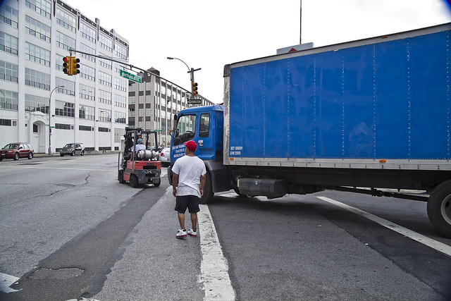
Another recent bit of serendipity experienced during a random walk, this time a bit further down Northern Blvd. and directly across the street from the Standard Motor Products building on 39th street, it seems that the good fellows who operate this largish delivery truck had experienced an unlucky turn when its engine suddenly stranded them. Luckily, they seemed to have a tiny red forklift on board, of a sort which I’ve always heard referred to as a “Bobcat”.
from wikipedia
Forklifts are rated for loads at a specified maximum weight and a specified forward centre of gravity. This information is located on a nameplate provided by the manufacturer, and loads must not exceed these specifications. In many jurisdictions it is illegal to remove or tamper with the nameplate without the permission of the forklift manufacturer.
An important aspect of forklift operation is that most have rear-wheel steering. While this increases maneuverability in tight cornering situations, it differs from a driver’s traditional experience with other wheeled vehicles. While steering, as there is no caster action, it is unnecessary to apply steering force to maintain a constant rate of turn.
Another critical characteristic of the forklift is its instability. The forklift and load must be considered a unit with a continually varying centre of gravity with every movement of the load. A forklift must never negotiate a turn at speed with a raised load, where centrifugal and gravitational forces may combine to cause a disastrous tip-over accident. The forklift are designed with a load limit for the forks which is decreased with fork elevation and undercutting of the load (i.e. load does not butt against the fork “L”). A loading plate for loading reference is usually located on the forklift. A forklift should not be used as a personnel lift without the fitting of specific safety equipment, such as a “cherry picker” or “cage”.

– photo by Mitch Waxman
The inert truck was borrowing its motive power from the smaller and self propelled tool. Its driver clearly seemed embarrassed by all the attention he garnered. Several of us stood on the corners, males all, sporting broad smiles and cheering him on while he waited for a red light to turn. This sort of situation appeals to we men, I don’t know why, but it does.
I was betting on either the inadequate chain just sundering into constituents, or the forklift burning out its transmission before it moved the giant blue vehicle more than a couple of feet.
from wikipedia
A high-tensile chain, also referred to as a transport chain, is a link chain with a high tensile strength used for drawing or securing loads. This type of chain usually consist of broad (thick/heavy) metal, oblong torus-shaped links for high strength. All the links of the chain are usually identical, and on the ends are usually two hooks of the appropriate size and strength to slide easily over one chain link but small enough not let the links slip by. When the ability to grasp the load is required, a slip hook is used.
The chain used for tire chains on tractors and some automobiles for better traction is very similar; usually consisting of the same type of link, especially so for snow chains; however, instead of being a single chain, it is more of a network of interconnected chains with no hooked ends; the size and design of the network depending on the tire it was intended for.

– photo by Mitch Waxman
The signal turned, and that tiny forklift and its driver wouldn’t let anything like the laws of Physics or the limits of engineering stop them from getting the truck moving.
Whom, indeed, says that an ant can’t move a rubber tree plant? Whom?
from wikipedia
They usually range in size 4 to 7 m in length, with smaller or larger sizes existing but being rare in North America. They usually have a garage door-like rear door that rolls up. On some box trucks, the cargo area is accessible from the cab through a small door.
Box trucks are usually used by companies that need to haul appliances or furniture. They are also used as moving trucks which can be rented from companies such as U-Haul or Ryder.
In North America, Ford, Dodge and Chevrolet/GMC have historically been the most common manufacturers of conventional cab/chassis to which various producers (called body builders or upfitters) attach the box that holds cargo. Isuzu, Mitsubishi Fuso and UD/Nissan Diesel have been the most common marketers of cabover-type medium duty cab/chassis used as platforms for box trucks. In North America, these trucks can range from Class 3 to Class 7 (12,500 lb. to 33,000 lb. gross vehicle weight rating, or GVWR).
– photo by Mitch Waxman
The drivers around these parts- borderland and angle between Sunnyside, Astoria, and Dutch Kills- are not exactly a sagacious or patient lot. Normal practice for them is to hit their horns in the quarter second before the traffic light goes from red to green, and to accelerate precipitously in an effort to “beat the lights”. Queens Plaza is nearby, and their probable destination of Manhattan- unlike Queens- is a heavily regulated and well policed thicket of traffic jams. This is their last chance to see the sky.
Well… not for long.
from wikipedia
A gross vehicle weight rating (GVWR) is the maximum allowable total mass of a road vehicle or trailer when loaded – i.e including the weight of the vehicle itself plus fuel, passengers, cargo, and trailer tongue weight.
The difference between gross weight and curb weight is the total passenger and cargo weight capacity of the vehicle. For example, a pickup truck with a curb weight of 4,500 pounds (2,041 kg) might have a cargo capacity of 2,000 pounds (907 kg), meaning it can have a gross weight of 6,500 pounds (2,948 kg) when fully loaded.

– photo by Mitch Waxman
Witness the tenacity and determination of the American workforce- its inchoate improvisations and hazard ridden solutions that keep the machines running no matter what, its complete disregard for official procedure and personal safety -unstoppable, indefatigable, the children of necessity.
from wikipedia
New York State Route 25A (NY 25A) is a New York State highway and the main east–west route for most of the North Shore of Long Island, running from the Queens Midtown Tunnel in the New York City borough of Queens at its western terminus to Calverton in Suffolk County at its eastern end.
Known for its scenic route through decidedly lesser-developed areas such as Brookville, Fort Salonga, Centerport, and the Roslyn Viaduct, 25A begins as 21st Street in Long Island City. As you go farther through 25A, it is then known as Jackson Avenue for a short period and is variously named Northern Boulevard east of Queens Plaza (NY 25), North Hempstead Turnpike, Main Street, Fort Salonga Road, and North Country Road. It merges with NY 25 for approximately 1.5 miles (2.4 km) in Smithtown.
Project Firebox 8

– photo by Mitch Waxman
This maladjusted servant of the City of Greater New York enjoys a tumultuous existence on 48th Avenue in Long Island City, not far from that tendril of cuprous cupidity known as Dutch Kills- a tributary waterway to the Newtown Creek. Your humble narrator has witnessed this firebox’s abuse filled duties for quite some time. It seems to be a regular target for trucks, and I’ve seen it reinserted into its assigned place several times. How do you not notice a big red box?


