Posts Tagged ‘Dutch Kills’
shivering gargoyles

– photo by Mitch Waxman
Gilman, Gilman, Gilman.
That note, attached to governmental correspondence, was signed Gilman. Impossible, unbelievable, and beyond sane reasoning… Gilman. As your humble narrator scuttled along in miserable mood, that certain day, I became convinced that my name was being called from some unknown point beyond the bulkheaded fence lines adorning that sewer fed ribbon of urban lore called the Newtown Creek.
I first heard the voice, while deep in denial at the Pulaski Bridge, a whispered gutteral which seemed like an isolated phenomena.
from wikipedia
Tutti Acceptance typically contains the concept of approval, it is important to note that in the psychospiritual use of the term infers non-judgmental Acceptance is contrasted with resistance, but that term has strong political and psychoanalytic connotations not applicable in many contexts. By groups and by individuals, acceptance can be of various events and conditions in the world; individuals may also accept elements of their own thoughts, feelings, and personal histories. For example, psychotherapeutic treatment of a person with depression or anxiety could involve fostering acceptance either for whatever personal circumstances may give rise to those feelings or for the feelings themselves. (Psychotherapy could also involve lessening an individual’s acceptance of various situations.)
Notions of acceptance are prominent in many faiths and meditation practices. For example, Buddhism’s first noble truth, “All life is suffering”, invites people to accept that suffering is a natural part of life. The term “Kabbalah” means literally acceptance.

– photo by Mitch Waxman
Isolating myself in a guilty agony, hiding behind dark sunglasses and a long iPhone playlist which had finally wound- inevitably- to the darker side of Patti Smith, I skirted the Creek and made for the River of Sound.
Overwhelmed by its inevitability of oligarchy, I noticed that the auditory hallucination that my name was being called from the water had abided, and the decision to make haste for the safety of almond eyed Astoria was wise, back to the loving arms of Our Lady of the Pentacle and the unquestioning devotion of my little dog Pazuzu.
from wikipedia
Karma is the belief held by some major religions that a person’s actions cause certain effects in the current life and/or in future life, positively or negatively.
For example, if a person always does good deeds then it is believed that he or she will be “rewarded” for his or her behavior with fortunate events such as avoiding fatal accident or winning the lottery. If he or she always commits antagonistic behaviors, then it is believed that he will be punished with unfortunate events.
According to Buddhism, inequality amongst living beings is due not only to heredity, environment, “nature and nurture”, but also to Karma. In other words, it is the result of our own past actions and our own present doings. We ourselves are responsible for our own happiness and misery. We create our own Heaven. We create our own Hell. We are the architects of our own fate.
Perplexed by the seemingly inexplicable, apparent disparity that existed among humanity, a young truth-seeker approached the Buddha and questioned him regarding this intricate problem of inequality:
“What is the cause, what is the reason, O Lord,” questioned he, “that we find amongst mankind the short-lived and long-lived, the healthy and the diseased, the ugly and beautiful, those lacking influence and the powerful, the poor and the rich, the low-born and the high-born, and the ignorant and the wise?”
The Buddha’s reply was:
“All living beings have actions (Karma) as their own, their inheritance, their congenital cause, their kinsman, their refuge. It is Karma that differentiates beings into low and high states.”
He then explained the cause of such differences in accordance with the law of cause and effect.

– photo by Mitch Waxman
Slipping and stumbling, my denial and self imposed hermitage blossomed into anger and rage, surely- the note signed by Gilman was nothing of the sort. The same agencies which have directed their gaze upon me are attempting to rub my nose in their power and my inability to react.
from wikipedia
Environmental determinism, also known as climatic determinism or geographical determinism, is the view that the physical environment, rather than social conditions, determines culture. Those who believe this view say that humans are strictly defined by stimulus-response (environment-behavior) and cannot deviate.
The fundamental argument of the environmental determinists was that aspects of physical geography, particularly climate, influenced the psychological mind-set of individuals, which in turn defined the behaviour and culture of the society that those individuals formed. For example, tropical climates were said to cause laziness, relaxed attitudes and promiscuity, while the frequent variability in the weather of the middle latitudes led to more determined and driven work ethics. Because these environmental influences operate slowly on human biology, it was important to trace the migrations of groups to see what environmental conditions they had evolved under.

– photo by Mitch Waxman
Attempting to bargain with this malicious universe called New York City, a foul harlot indeed, I wandered into the empty corridor in a tightly compressed state of mind. Encounters with security men, and other creatures of the street not mentioned in the posting, formed a silo of despair about me.
from wikipedia
“Forbidden fruit” is any object of desire whose appeal is a direct result of the knowledge that it cannot or should not be obtained or something that someone may want but is forbidden to have. The metaphorical phrase forbidden fruit refers to the Book of Genesis, where it is the fruit of the Tree of Knowledge of Good and Evil eaten by Adam and Eve in the Garden of Eden. As a result of their decision to eat the fruit, Adam and Eve lost their innocence, became separated from God and were exiled from the garden where they were forced to adopt agriculture under less than desirable circumstances for a living.

– photo by Mitch Waxman
Finally, as the vapor dulled sunbeams cast those queer shadows which form the tenebrous patterns distinctive of the Newtown Creek and its tributaries during the humid and hot months, your humble narrator was forced into acceptance of the notation- written in atavist hand on a scrap of brown kraft paper which smelled of salted cod- as genuine.
from wikipedia
The Qur’an doesn’t name this tree and it is always referred to as “the tree”. Muslims believe that when God created Adam and Eve, He told them that they could enjoy everything in the Garden but this tree, and so, Satan appeared to them and told them that the only reason God forbade them to eat from that tree is that they would become Angels or become immortals.
When they ate from this tree their nakedness appeared to them and they began to sew together, for their covering, leaves from the Garden. As a result of their sin, they were removed from heaven and placed on Earth to live and die. Consequently, they repented to God and asked for his forgiveness and were forgiven. It was decided that those who obey God and follow his path shall be rewarded with everlasting life in Heaven, and those who disobey God and stray away from his path shall be punished in Hell.

– photo by Mitch Waxman
By the time I came to Dutch Kills, at the Hunter’s point avenue bridge, I had managed to subsume this fact when I noticed that the hallucination had returned. A gurgling echo, which could have easily been the sound of some unknown machine reverbing along the cement, or some far off car stereo, or some physical effect caused by playing the music on my headphones too loudly for too long.
And I noticed that the vegetation along the shoreline was stained with the colour, and it was swaying against the breeze.
from wikipedia
The Biblical description of the garden says :
Now a river flowed out of Eden to water the garden; and from there it divided and became four rivers. The name of the first is Pishon; it flows around the whole land of Havilah, where there is gold.[…] The name of the second river is Gihon; it flows around the whole land of Cush. The name of the third river is Tigris; it flows east of Assyria And the fourth river is the Euphrates.
There have been a number of claims as to the actual geographic location of the Garden of Eden, though many of these have little or no connection to the text of Genesis. Most put the Garden somewhere between Najaf and Kufa in the Middle East.

– photo by Mitch Waxman
One thing I can tell you, lords and ladies of Newtown, is that the search for Gilman- rather than being retarded by this mysterious missive- will be redoubled. Whoever Gilman was, somebody in a high position does not want his story told. The note, written in old timey handwriting, is worrisome.
Gilman, who -and perhaps, what – were you?
from wikipedia
In many myths the chthonic serpent (sometimes a pair) lives in or is coiled around a Tree of Life situated in a divine garden. In the Genesis story of the Torah and Biblical Old Testament the Tree of the Knowledge of Good and Evil is situated in the Garden of Eden together with the tree of immortality. In Greek mythology Ladon coiled around the tree in the garden of the Hesperides protecting the entheogenic golden apples.
Similarly Níðhöggr (Nidhogg Nagar) the dragon of Norse mythology eats from the roots of the Yggdrasil, the World Tree.
Under yet another Tree (the Bodhi tree of Enlightenment), the Buddha sat in ecstatic meditation. When a storm arose, the mighty serpent king Mucalinda rose up from his place beneath the earth and enveloped the Buddha in seven coils for seven days, not to break his ecstatic state.
opiate peace

– photo by Mitch Waxman
This is not a dead place, this Creek which forms the currently undefended border between much of Brooklyn and Queens, despite wholly inaccurate statements to the contrary recently presented by major publications. To begin with, there is the teeming human infestation, whose population is in the millions. Additionally- migratory birds, invertebrate and vertebrate water fauna, and an enormous hidden population of higher mammals lurk amongst the canalized shorelines of the Newtown Creek.
from the nytimes.com– an article that gets a lot of things completely wrong, which is surprising for the times, and seems to be shilling against “Big Oil”
People don’t often think of urban creeks as biodiverse waterways, but Newtown Creek was once a rich tidal estuary popular among hunters and fishermen. Starting in the 1870s, however, Standard Oil and other refineries began spilling or dumping excess fuels and toxic chemicals into the water or onto the soil, slowly poisoning the ecosystem.

– photo by Mitch Waxman
Famously and recently, a Dolphin’s appearance near the Pulaski Bridge excited the neighboring communities, but such extravagances of nature would have a difficult time at Newtown Creek. There are ocean going and brackish water fish that get swept into the Creek by the East River’s irresistible tidal cycles, which actually drown in the oxygen poor water, but I’ve observed other things swimming in its shallow depths. Weird squamous things that defy description, burrowers and soft bodied tunnelers which thrive in the putrid muds that line its soft bottom. Perhaps, when the federal EPA superfund work begins, studies of these uncommented organisms will commence.
Hey, not everything that lives is beautiful, but against all the odds- life is tenacious and nature will find a way to get by.
from epa.gov
Newtown Creek is a part of the New York – New Jersey Harbor Estuary that forms the northernmost border between the New York City boroughs of Brooklyn and Queens. In the mid 1800s, the area adjacent to the 3.8 mile Newtown Creek was one of the busiest hubs of industrial activity in New York City. More than 50 refineries were located along its banks, including oil refineries, petrochemical plants, fertilizer and glue factories, sawmills, and lumber and coal yards. The creek was crowded with commercial vessels, including large boats bringing in raw materials and fuel and taking out oil, chemicals and metals. In addition to the industrial pollution that resulted from all of this activity, the city began dumping raw sewage directly into the water in 1856. During World War II, the creek was one of the busiest ports in the nation. Currently, factories and facilities still operate along the creek. Various contaminated sites along the creek have contributed to the contamination at Newtown Creek. Today, as a result of its industrial history, including countless spills, Newtown Creek is one of the nation’s most polluted waterways.
Various sediment and surface water samples have been taken along the creek. Pesticides, metals, PCBs, and volatile organic compounds (VOCs), which are potentially harmful contaminants that can easily evaporate into the air, have been detected at the creek.
In the early 1990s, New York State declared that Newtown Creek was not meeting water quality standards under the Clean Water Act. Since then, a number of government sponsored cleanups of the creek have taken place. The New York City Department of Environmental Protection has sampled sediment and surface water at a number of locations along the creek since 1980. In 2009, EPA will further sample the sediment throughout the length of Newtown Creek and its tributaries. The samples will be analyzed for a wide range of industrial contaminants. EPA will use the data collected to define the nature of the environmental problems associated with Newtown Creek as a whole.
after cycles incalculable

– photo by Mitch Waxman
The Romans had one of their very practical holidays scheduled for this week of the year, a mostly forgotten rite called the Lemuralia.
from wikipedia
In Roman religion, the Lemuralia or Lemuria was a feast during which the ancient Romans performed rites to exorcise the malevolent and fearful ghosts of the dead from their homes. The unwholesome spectres of the restless dead, the lemures or larvae were propitiated with offerings of beans. On those days, the Vestals would prepare sacred mola salsa, a salted flour cake, from the first ears of wheat of the season.

– photo by Mitch Waxman
The notion of vengeful ghosts, whom the Romans would call- in hushed whispers- the Larvae is ancient and seems to be bred into the human specie.
Those who celebrated the Lemuralia, walked barefooted, washed their hands three times, and threw nine times black beans behind their backs, believing by this ceremony to secure themselves against the Lemures (Varro, Vita pop. Rom. Fragm. p241, ed. Bipont.; Servius, ad Aen. I.276).

– photo by Mitch Waxman
The Egyptians had their Khu, and China has the Hungry Ghosts, even the Inuit tradition carries a haunting cadre of supernormal entities.
from wikipedia
In Roman mythology, lemures (singular lemur) were shades or spirits of the restless or malignant dead, and are probably cognate with an extended sense of larvae (sing. larva = mask) as disturbing or frightening. Lemures is the more common literary term but even this is rare: it is used by Horace, and by Ovid in his Fasti. Lemures may represent the wandering and vengeful spirits of those not afforded proper burial, funeral rites or affectionate cult by the living: they are not attested by tomb or votive inscriptions. Ovid interprets them as vagrant, unsatiated and potentially vengeful di manes or di parentes (ancestral gods of the underworld). To him, the rites of their cult suggest an incomprehensibly archaic, quasi-magical and probably very ancient rural tradition. Much later, St. Augustine describes both the lemures and the larvae as evil and restless manes that torment and terrify the living: lares, on the other hand, are good manes.

– photo by Mitch Waxman
Of course, our life here in the Newtown Pentacle is defined by more mundane concepts and material realizations. The Larvae we experience in early May, like these enigmatic critters found near the Hunters Point Ave. Station on Skillman Avenue, are decidedly “normal” and also happen to be native New Yorkers.
Your humble narrator has stumbled before, but with extensive comparison to extant critter speciation via the google… I’m going to go out on a limb here and proclaim these squirming masses of endless hunger Malacosoma Americanum!!! That’s the Eastern Tent Caterpillar to you, Lords and Ladies!!!
and apologies for the “out on a limb” pun- couldn’t resist…
(and also, I could be totally wrong- but these guys look like Malacosoma Americanum to me- if you can confirm or deny, please leave a comment)
from wikipedia
The newly hatched caterpillars initiate the construction of a silk tent soon after emerging. They typically aggregate at the tent site for the whole of their larval life, expanding the tent each day to accommodate their increasing size. Under field conditions, the caterpillars feed three times each day, just before dawn, at mid-afternoon, and in the evening after sunset. During each bout of feeding the caterpillars emerge from the tent, add silk to the structure, move to distant feeding sites en masse, feed, then return immediately to the tent where they rest until the next activity period. The exception to this pattern occurs in the last instar when the caterpillars feed only at night. The caterpillars lay down pheromone trails to guide their movements between the tent and feeding sites. The insect has six larval instars. When fully grown, the caterpillars disperse and construct cocoons in protected places. The adult moths (imago) emerge about two weeks later. They are rather strictly nocturnal and start flying after nightfall, then possibly stop some hours before dawn. Mating and oviposition typically occur on the same day as the moths emerge from their cocoons; the females die soon thereafter.

– photo by Mitch Waxman
Positively raining down from the trees, vast chaotics of these crawlers were observed the other day trying to cross Skillman Avenue, heading eastward.
The Eastern Tent Caterpillar, Malacosoma americanum (Fabricius) is reported to have been present in the United States since the 1600’s, and is responsible for forming unsightly silk-webbed nests at branch forks. Their population peaks every 8 to 10 years, when large infestations can completely defoliate trees in late spring/early summer.

– photo by Mitch Waxman
Virtually impossible to find footing which did not render a horrible and crushing extermination, I nevertheless scuttled forth and picked my way amongst them. In the back of my mind, I wondered what evolutionary adaptations they might have developed to accommodate the environmental hostility of this section of Long Island City. There is a High School across the street, of course- surrounded by the tunnels, trains, highways, bridges, and the cemented reality of an area defined by the junction of the main waterway of the Newtown Creek with its bubbly tributary- the canalized Dutch Kills. Just a block away is the Empty Corridor.
from esf.edu
These caterpillars produce the conspicuous silken tents commonly seen in the spring on branches of favored host trees. The tents consist of numerous layers of dense silk webbing which contain much excrement and numerous molted skins.
The female moths are dull reddish-brown with a wing expanse of 1 1/2 to 2 inches. Males are smaller. The front wings of each are crossed by two whitish, oblique, parallel lines.
Mature larvae, or caterpillars, are 2 to 2 1/2 inches long. The head and body are generally deep black. There is a white stripe along the back of the body and a row of oval, pale blue spots on each side. There are many short, irregular brownish markings on the side of each body segment. Long, fine, brown hairs sparsely clothe the body.

– photo by Mitch Waxman
These wriggling americans were pursuing some unknown goal in the direction of that High School, and the actions of automotive traffic along Skillman Avenue upon their migration is a detail best left unheralded. Vast hatcheries of avian predators swirled above.
from nysipm.cornell.edu
Manual destruction of egg masses and tents is an excellent way to control populations. Be advised that the hairs on caterpillars may be irritating to skin.
Twigs encased by egg masses should be pruned out. Tents can also be pruned out or be destroyed by winding around a stick or with a strong jet of water (the best time to destroy tents is before caterpillars leave to feed). Do not attempt to burn tents as this can cause more harm than good.
Tent destruction has another benefit in that it exposes caterpillars to birds and other natural enemies which can help keep populations in check. Eastern tent caterpillars are parasitized by braconid, ichneumonid, and chalcid wasps.
Other control options are available: Bacillus thuringiensis var. kurstaki is useful in the early spring when applied to young larvae, as is insecticidal soap which should be used when caterpillars are out of tents and feeding on leaves. Take care to avoid applying soaps in unsuitable weather conditions (like hot temperatures) as this can lead to phytotoxicity and leaf damage.

– photo by Mitch Waxman
The univoltine holocaust playing out all around me forced me to rumination, a meditative practice whose purpose is to ward off the periodic moments of panic and fainting which have so afflicted me in the past. Feckless quisling and physical coward both, your humble narrator revels in heroic tales of the past, for the future is a paralysis of logical progressions and dire portent.
from wikipedia
The origin of the festival of All Saints celebrated in the West dates to May 13, 609 or 610, when Pope Boniface IV consecrated the Pantheon at Rome to the Blessed Virgin and all the martyrs; the feast of the dedicatio Sanctae Mariae ad Martyres has been celebrated at Rome ever since. The chosen day, May 13, was a pagan observation of great antiquity, the culmination of three days of the Feast of the Lemures, in which the malevolent and restless spirits of the dead were propitiated. Liturgiologists of the Middle Ages based the idea that this Lemuria festival was the origin of that of All Saints on their identical dates and on the similar theme of “all the dead”.
The feast of All Saints, on its current date, is traced to the foundation by Pope Gregory III (731–741) of an oratory in St. Peter’s for the relics “of the holy apostles and of all saints, martyrs and confessors, of all the just made perfect who are at rest throughout the world”, with the day moved to November 1.

– photo by Mitch Waxman
Negative thoughts, though, on a sunny warm day in the City of Greater New York will only attract attention to you. Best to throw open the psychic windows and air the mental house out, clean up and organize for the coming summer. Perhaps the Romans had something after all, the Lemuralia was always accompanied by a general cleaning of the home, a spring cleaning.
from wikipedia
On Sunday, 13 May 1917, ten year old Lúcia Santos and her younger cousins, siblings Jacinta and Francisco Marto, were tending sheep at a location known as the Cova da Iria near their home village of Fátima in Portugal. Lúcia described seeing a woman “brighter than the sun, shedding rays of light clearer and stronger than a crystal ball filled with the most sparkling water and pierced by the burning rays of the sun.” Further appearances are reported to have taken place on the thirteenth day of the month in June and July. In these, the woman exhorted the children to do penance and to make sacrifices to save sinners. The children subsequently wore tight cords around their waists to cause pain, abstained from drinking water on hot days, and performed other works of penance. Most importantly, Lúcia said that the lady had asked them to pray the rosary every day, repeating many times that the rosary was the key to personal and world peace. This had particular resonance since many Portuguese men, including relatives of the visionaries, were then fighting in World War I.
According to Lúcia’s account, in the course of her appearances, the woman confided to the children three secrets, now known as the Three Secrets of Fátima.

– photo by Mitch Waxman
The Lemures are always with us, after all, and they’ll always be back.
Have a good day on the 13th of May, eat something bad for you with someone you love- and fellows- wash your hands and throw some black beans around the neighborhood later. You never know.
I really have to recommend against walking bare footed, however.
strange and brooding apprehensions
CREEK WEEK continues… for the first installment, from the mouth at the East River to the Pulaski Bridge, click here. For more on just the Pulaski Bridge, click here.

– photo by Mitch Waxman (from the Queens Museum of Art’s “Panorama of the City of New York”)
Moving a quarter mile eastward along the Queens bulkheads of the Newtown Creek from the Pulaski Bridge, the first tributary encountered by the intrepid urban explorer and photographer is a canalized horror called the Dutch Kills.
This branch of the Newtown Creek watershed is about an hour’s walk from Newtown Pentacle HQ, and its locale is visited or transited rather regularly by your humble narrator, as I perform the penitential exertions ordered by my physicians as the curative for certain extant health issues. All ‘effed up, my version of such wholesome activity requires the presence of the macabre, and some element of existential danger. Luckily- the Newtown Creek offers, to those who seek it, succor and salvation for a variety of desires.
Detailed postings, in and around the immediate neighborhood of the Dutch Kills waterway, include:
- Dutch Kills, or let the Photos do the Walking
- Long Island City Zen 2 -The Empty Corridor
- Weird Synchronicity
- After the Fire
- affordable housing development on Borden Avenue
- cry fowl, and let slip…
from wikipedia
Dutch Kills is a sub-division of the larger neighborhood of Long Island City in the New York City borough of Queens. It was a hamlet, named for its navigable tributary of Newtown Creek, that occupied what today is centrally Queensboro Plaza. Dutch Kills was an important road hub during the American Revolutionary War, and the site of a British Army garrison from 1776 to 1783. The area supported farms during the 19th Century, and finally consolidated in 1870 with the villages of Astoria, Ravenswood, Hunters Point, Middletown, Sunnyside and Bowery Bay to form Long Island City.

– photo by Mitch Waxman
Leaving the main course of the Newtown Creek, just .8 of a mile beyond its mouth, the first thing one encounters is a somewhat worse for wear railroad swing bridge- called the Long Island Railroad Bridge. Reports from “railfans” and “foamers” (and confirmed by the Coast Guard) state that the bridge hasn’t opened since 2002, which has orphaned the Dutch Kills from its parent waterway and cut the canal off from its intended usage. If my readings of old maps are correct (they often aren’t), these two tracks carry (or at least carried) rail traffic from either the Montauk Cutoff and Montauk Branch tracks, connecting the LIRR to the Sunnyside Yard and Wheelspur Yard with the tracks leading west to Hellsgate and east to Long Island. Notable former sights along this bank of the Newtown Creek would have been the City of New York’s Poultry Yard and the still extant Texas Oil Co.
For an extensive series of historical photos, discussion of the function and design of these tracks, and the industrial centers they once served- trainsarefun.com is the place to go. Special attention is called to this 1860 map of the area– which details the natural flow of the wetlands and shows the Dutch Kills as being a far larger body of water than it is today.
from Queens Borough, New York City, 1910-1920
During 1914 bulkhead lines were established by the United States Government for Dutch Kills Creek, a tributary of Newtown Creek, thus putting this stream under the jurisdiction of the War Department. The bulkhead lines as approved on October 29, 1914, give a width varying from 200 feet at its junction with Newtown Creek to 150 feet at the head of the stream, and include a large basin in the Degnon Terminal where car floats can be docked. The widths of the channel to be dredged under the appropriation of $510,000 mentioned previously, range from 160 feet at Newtown Creek to 75 feet at the turning basin. The Long Island Railroad plans to establish at this point a large wholesale public market, estimated to cost nearly $5,000,000.
Among the larger industrial plants in the Degnon Terminal served by this stream are : Loose Wiles Biscuit Company, American Ever Ready Works, White Motor Company, Sawyer Biscuit Company, Defender Manufacturing Company, Pittsburg Plate Glass Company, Marcus Ward, Brett Lithograph Company, Waldes, Inc., Norma Company of America, Manhattan-Rome Company, American Chicle Co. and The Palmolive Co.

– photo by Mitch Waxman
From Borden avenue, the second rail bridge is observed, which I believe to be the Montauk Cutoff track and a bascule type drawbridge. The canalized Dutch Kills, with its high bulkheads and rail connections, served as a water connection to NY Harbor for several heavy manufacturers in the area including F.A. Hunt, Holdtronics, New York Envelope, and American Chicle. The rail/dock complex, collectively, was known as the Degnon terminal. A short but sweet history of the Degnon Terminal can be accessed at members.trainweb.com. Michael Degnon was a master builder, one of the great men of the early 20th century in Queens, and is buried in Calvary Cemetery. Check out this nytimes.com article which discusses an expansion of his operations at the Dutch Kills in 1922 that brought floor space at his Degnon Terminal up to an astounding three million square feet.
from forgotten-ny.com
Michael Degnon was the contractor for the Steinway Tunnel, the first rail link to connect Manhattan and Queens, and also the contractor for the Sunnyside Yards. He decided to build his own railway, called Degnon Terminal, adjacent to the Sunnyside Yards and constructed large factories and warehouses complete with sidings facing the railroad tracks. This was attractive to his clients, since shipping goods via rail was now more accessible and less expensive for them. Some of the Terminal’s early clients were Sunshine Biscuit Company, Packard Automobile Company, American Ever Ready Company, and American Chicle Company. Of course, the rising cost of doing business in New York forced all of these companies to find other cities in which to manufacture. The sidings haven’t seen rail traffic since 1989, and the tracks are now either paved over or overgrown with weeds (some of which can be seen on FNY’s Disappearing Railroad Blues page). In its heyday, Degnon Terminal employed 16,000 workers.

– photo by Mitch Waxman
The currently “under construction” Borden Avenue Bridge allows vehicle and pedestrian traffic to cross the Dutch Kills. This is the point at which the water quality declines seriously, as the only fresh water entering its stagnant depths are combined sewer outputs (CSO’s) and runoff from the concretized industrial landscape surrounding it (which carry a stream of road salt, engine and exhaust residue, and whatever else might be on the road or sidewalk into the water every time it rains). The bridge recently celebrated its centennial, incidentally.
from the army corps of engineers, discussing precautions for the collecting, handling, and testing of Dutch Kills underwater sediments:
All individuals involved in handling contaminated sediment are required to use protective equipment and to submit to blood and urine tests. The protective equipment consists of:
from nyc.gov
As part of the construction of Borden Avenue in 1868, a wooden bridge was built over Dutch Kills. This bridge was later replaced by an iron swing bridge, which was removed in 1906. The current bridge was opened on March 25, 1908 at a cost of $157,606. The deck’s original design consisted of creosote-treated wood blocks, with two trolley tracks in the roadway. Character-defining features of this bridge include the stucco-clad operator’s house, four pairs of rails, and a rock-faced stone retaining wall. The gable-on-hip roof of the operator’s house retains the original clay tile at the upper part. Although alterations have been made, the bridge is a rare survivor of its type and retains sufficient period integrity to convey its historic design significance.
The Department of Transportation has identified a pocket of contaminated soil which has been classified as “contaminated non-hazardous”. As such, it poses no significant health risk to workers or the surrounding community. However, precautionary measures will be taken and every effort is being made to remove and dispose of the contamination quickly, yet safely, within all New York City and State guidelines. A Corrective Action Plan (CAP) for the removal and disposal of the contamination has been submitted to the NYS Department of Environmental Conservation (NYSDEC) for review and approval.

– photo by Mitch Waxman
Sewer construction projects along Hunters Point Avenue revealed that the swampy nature of western Queens is unchanged. These ground waters, as you might observe by the chalk markings on the pilings, would be some 13 feet beneath the streets. The vertical clearance of the nearby Hunters Point Avenue Bridge (and street grade) is approximately 15 feet over the water, so this would make sense.
Never forget, lords and ladies, that this Long Island City of ours is a swamp which was “reclaimed” by industrial means just within the last 150 years. The “ground” in most of the area is actually a sort of pier or dock, with timber pilings supporting cement clad fill. Just two stories down are the waters of the Newtown Creek and it’s tributaries, and this sort of subterrene terraforming is typical for most of the spongy land directly surrounding the Newtown Creek.
Who can guess, what poisons there are, laying in the mud waiting to hatch out?
from hydroqaul.com
Like a number of other local tributaries to New York Harbor, Newtown Creek is now simply a peripheral canal system fed by tides, CSO and stormwater discharges. None of its original freshwater creeks and extensive wetlands exist anymore, the whole area having been transformed into a series of canals by channelization, land reclamation (filling) and bulkheading. Biological abundance and diversity is impaired by reductions in the amount and variety of physical habitat, and by a vulnerability of the remaining habitat to retention and accumulation of pollutants. Although no scientific studies have been identified prior to 2001, it can be expected that biota of Newtown Creek reflect similar conditions in other highly impacted waterbodies around the harbor. Thus, a fouling community composed of epibenthic invertebrates such as barnacles and sea squirts should be present on pilings and bulkheads; a fairly homogenous community of benthic invertebrates dominated by tolerant forms of polychaete worms should be found in the sediments, and a typical assemblage of regionally indigenous fish such as striped bass, winter flounder, bay anchovy, Atlantic menhaden, snapper bluefish, sea robin and tautog may come and go as water levels and quality permit.

– photo by Mitch Waxman
The Hunter’s Point Avenue Bridge offers spectacular views of the Long Island Expressway with Brooklyn beyond, and from its walkway; the bulkheads marking the end of the Dutch Kills are visible. This is a dead zone, check out riverkeeper.org’s analysis of the waters here over a multiple year period. The foulness of these waters are part of the historical record, which an a New York Times article from March of 1871 proves, and the evidences of one’s own senses suggest.
from nyc.gov
The Hunters Point Bridge over Dutch Kills is situated between 27th Street and 30th Street in the Long Island City section of Queens, and is four blocks upstream of the Borden Avenue Bridge. It is a bascule bridge with a span of 21.8m. The general appearance of the bridge has been significantly changed since it was first opened in 1910. The bridge provides a channel with a horizontal clearance of 18.3m and a vertical clearance, in the closed position, of 2.4m at MHW and 4.0m at MLW. The bridge structure carries a two-lane, two-way vehicular roadway with sidewalks on either side. The roadway width is 11.0m, while the sidewalks are 1.8m wide. The width of the approach roadways vary from the width of the bridge roadway. The west approach and east approach roadways are 13.4m and 9.1m, respectively.
The first bridge at this site, a wooden structure, was replaced by an iron bridge in 1874. That bridge was permanently closed in 1907 due to movement of the west abutment, which prevented the draw from closing. It was replaced in 1910 by a double-leaf bascule bridge, designed by the Scherzer Rolling Lift Bridge Company. The bridge was rebuilt in the early 1980’s as a single-leaf bascule, incorporating the foundations of the previous bridge.

– photo by Mitch Waxman
At the end of the Dutch Kills, one finds a concrete company, and the former Degnon Terminal home of Sunshine Biscuits, which today serves as the “C’ building of the LaGuardia Community College campus (found between 29th and 30th streets and between 47th avenue and the intersection of Skillman and Thompson avenues). Additionally, the greater astoria historical society has posted a photo at smugmug that shows the rest of the scene in the shot above dating from 1966.
speaking of gahs, they have a short history of Sunshine Biscuit’s “thousand window factory” which can be accessed by clicking here

– photo by Mitch Waxman
A quick glance down at the banks of Dutch Kills reveal the true nature of things here, it is not uncommon to half glance at dead things floating by, suspended by their internal gases. At high tide on the East River, aquatic life often finds its way into the Newtown Creek and become entrapped in the oxygen deprived water. This provides ample food for thriving colonies of carnivorous worms and shore line scavengers- mainly river rats, the cats that prey on them, and various birds.
Few if any dogs have I observed down here, even where you’d expect them to be. Guard dogs are unemployed around these parts, and I’ve never seen a feral dog roaming around in all the time I spend scuttling around the area- but that’s probably because of all the trucks. I do know a fat old dog who’s chained to a fish butcher on 51st avenue, but she’s mainly interested in her sunny sidewalk and sleeping.
from nytimes.com
Hunters Point South, for its part, will have 5,000 homes built on 30 acres on the edge of the East River, near Newtown Creek. Three thousand of the homes will be set aside for families whose annual income totals $126,000 or less, with 800 of them destined specifically to families who earn less than $61,400 a year. There will also be 300 units built for low-income senior citizens and at least 225 units devoted to a middle-class homeownership program.
“We’re creating a model,” said Councilman Eric N. Gioia, whose district includes the area where the project will be built. “We’re creating housing where all New Yorkers can live together, in the same neighborhood.”

– photo by Mitch Waxman
At the end of Dutch Kills, near 47th avenue, illegal dumping seems to be a community passion. There is even a rusted out and derelict barge which seems to finally be sinking. As always, admonishment and advice for the urban explorer to ignore the temptation to climb out and take a look applies. The wet filth that lines the shore here stinks of sulphur compounds, and the smell of a sick aquarium permeates the breeze. This is also a HAZMAT zone, and nautical charts reveal that the water depth here is 13-15 feet, roughly a third deeper than it is in the channel. Don’t screw around back here, lords and ladies, you can get seriously hurt.
from nyc.gov, on the waterfront revitalization section of the Hunters Point South development plan
Policy 6.2: Direct public funding for flood prevention or erosion control measures to those locations where the investment will yield significant public benefit.
The proposed actions do not include public structural flood and erosion control projects. The central and eastern portion of Site A and much of Site B are within the 100-year floodplain.
The New York City Building Code (Title 27, Subchapter 4, Article 10) requires that residential buildings have a finished floor elevation (FFE) at or above the 100-year floodplain, while the Federal Emergency Management Agency (FEMA) requires the FFE to be one foot above the 100-year floodplain. In accordance with these regulations and as stated above, clean fill would be used to raise the development area, including the areas for new streets and buildings, as well as portions of the project sites designated for the waterfront park or other open space areas that would not be covered by impervious surface or structures. Raising the elevation of the project sites above the 100-year flood elevation would ensure protection of public health and safety, the new buildings and open space areas, public investment of city infrastructure, and enhancement of natural habitats. The proposed actions are consistent with this policy.

– photo by Mitch Waxman
On the Brooklyn side of the Newtown Creek is another tributary called Whale Creek (don’t worry, we’ll be going there soon enough), alongside which the magnificent Newtown Creek Wastewater Treatment Plant hums and belches methane in storied Greenpoint. This spot on 29th street, at the end of the Dutch Kills, is just under a half mile from the main channel.
A Newtown Pentacle posting from October of 2009 explored this Temple of Cloacina, which is a 24 hours a day municipal workhorse. The plant processes a significant percentage of the 1.1 billion gallons of sewage New York produces every day, delivering it in a milled and concentrated form to a pumping tank and dock in Greenpoint directly across the Creek from the forthcoming Hunters Point South development which is just starting on the Queens shoreline. In still another posting, we followed some sludge boats- the M/V Newtown Creek, North River, and the Red Hook, as they traveled past Hallet’s Cove and Astoria up the East River.
from nyc.gov
Dewatering reduces the liquid volume of sludge by about 90%. New York City operates dewatering facilities at eight of its 14 treatment plants. At these facilities, digested sludge is sent through large centrifuges that operate like the spin cycle of a washing machine. The force from the very fast spinning of the centrifuges separates most of the water from the solids in the sludge, creating a substance knows as biosolids. The water drawn from the spinning process is then returned to the head of the plant for reprocessing. Adding a substance called organic polymer improves the consistency of the “cake”, resulting in a firmer, more manageable product. The biosolids cake is approximately 25 to 27 percent solid material.

Hunters Point to Dutch Kills with Whale Creek on the left – photo by Mitch Waxman (from the Queens Museum of Art’s “Panorama of the City of New York”)
Creek Week continues… at this, your Newtown Pentacle. Prepare to penetrate into the darkness of the tomb legions, lords and ladies… as we move eastward.
highly visible
Broadway near Steinway Street – photo by Mitch Waxman
As your humble narrator scuttles from place to place, turning over rocks to see what blind albino abnormalities might lurk beneath, a significant amount of road construction is encountered. New York is always in a state of near collapse and an army of municipal and contractor labor is kept busy filling in the cracks. Conflicted over sneaking pictures of these folks, I nevertheless find them fascinating, for the high visibility colors they wear excite the eye.
from workzonesafety.org
Title: ANSI/ISEA 107-2004: Revised American National Standard for High-Visibility Safety Apparel and HeadwearAbstract: This standard provides a uniform, authoritative guide for the design, performance specifications, and use of high-visibility and reflective apparel including vests, jackets, bib/jumpsuit coveralls, trousers and harnesses. Garments that meet this standard can be worn 24 hours a day to provide users with a high level of conspicuity through the use of combined fluorescent and retroreflective materials. The revised version of the standard expands the product coverage to include high-visibility headwear. It also contains additional testing procedures for knitted fabrics used as background material, and eliminates tests from the previous edition that added no value. Publisher: International Safety Equipment Association

Third Avenue Manhattan – photo by Mitch Waxman
If it won’t blind or distract the crews, don’t forget that this is heavy industry and quite dangerous work, try turning on the camera flash when photographing them. The reflective fabrics, technically retroreflective fabrics (which function like a Cat’s eyeshine), will blaze up and be the brightest point in the photo. New York City street signs also function in a similar fashion, and even the weakest flash will light them up from blocks away. Try it, especially on a dark and stormy day, the effects are somewhat unpredictable and often produce a prismatic and surreal photo.
from simplifiedsafety.org
Class 1: needs to be conspicuous and use retroreflective materials not less than 25mm in width.
- Used when workers are well separated from traffic
- Vehicle speeds of less than 25 mph
- Parking attendants
- Shopping cart retrievers
- Warehouse workers
- Roadside/sidewalk maintenance workers
- Delivery vehicle drivers
Class 2: maintains superior visibility and are more conspicuous than the Class 1 garments. Minimum width of retroreflective material used on these is not less than 35mm.
- Used when workers are on or near roadways
- Vehicle speeds of 25 to 50 mph
- Roadway construction workers
- Utility workers
- Survey crews
- Law enforcement personnel
- Crossing guards
- High-volume parking lot or toll-gate attendants
- Airport baggage handlers and ground crews
- Railway workers
- Emergency response personnel
- Accident site investigators
Class 3: has greatest visibility. Maintains more retroreflective material than Class 2 and must have sleeves with retroreflective material between the shoulders and elbows. Not less than 50mm wide of retroreflective material.
- Used for workers in high risk situations
- Allows them to be seen from a minimum distance of 1,280 ft.
- Vehicle speeds of greater than 50 mph
- Roadway construction workers
- Utility workers
- Survey crews
- Emergency response personnel

31st street, Astoria – photo by Mitch Waxman
All of the municipal and construction rules are meant to conform to the national OSHA specifications, but individual city organizations have their own wrinkle on safety gear. MTA workers, for instance, are often observed wearing goggles and ear protection as they work. No doubt, this is due to individual union agreements and task specific requirements.
from nysdot.gov
All DOT employees, contractor employees and visitors must wear protective helmets and high visibility construction apparel while working within a highway right of way or contract limits. Flaggers must wear high visibility traffic control apparel when directing or spotting traffic. High-visibility apparel is not required for employees and visitors when they are within a completely enclosed cab constructed of steel frame and glass, or inside a motor vehicle.

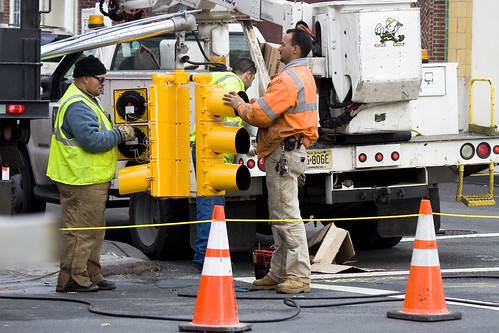
37th avenue, Dutch Kills – photo by Mitch Waxman
NYFD, of course, has the most stringent series of rules for its crews. In the shot above, a 5 alarm fire at an industrial warehouse was belching black smoke into the street, but the firefighters are clearly identifiable through the murk- due to camera flash. Be careful around NYFD however, as they’re kind of busy people, and you don’t want to distract them. Also, should there be any piezoelectric activated equipment in use- DO NOT use your flash for fear of activating something.
from fasny.com
Back in November of 2008, there was a lot of confusion about the use of high-visibility vests at roadway incidents due to a new Federal Highway Administration (FHWA) Rule. The new regulation, Rule 634, stated that “All workers within the right-of-way of a Federal-aid highway who are exposed either to traffic (vehicles using the highway for purposes of travel) or to construction equipment within the work area shall wear high-visibility safety apparel.”
That regulation created a dilemma for fire departments who were truly interested in protecting their personnel. The training classes and material used by the Emergency Responder Safety Institute (ERSI) for years has suggested the use of high-visibility garments for public safety personnel when working around traffic. NFPA 1500, the Firefighter Health and Safety Standard has included a requirement for firefighters to wear safety vests at traffic incidents in the last two most recent editions. NIOSH Line of Duty Death Investigations have also included recommendations for responders to wear highly visible flagger vests when exposed to moving traffic. In the fire service community it was generally understood that the vests were not appropriate personal protective equipment (PPE) for personnel who were actively engaged in firefighting operations because those garments are not designed for exposure to fire, heat flame or hazardous materials. Rule 634, as originally published however did not outline any exemptions for firefighters engaged in direct firefighting operations and that created the dilemma.

Bridge Plaza North, Queens Plaza – photo by Mitch Waxman
The shot above is fascinating to me, for reasons that have little to do with the safety equipment exhibited. The trench that this trio is working in is down by Queens Plaza, and the cutaway shows a historical record. Notice the top layer of asphalt, then two distinct layers of cobblestones, then dirt and rock fill. Asphalt- modern, cobbles 1- the construction of the Queensboro bridge and associated roadways, cobbles 2- the pre bridge street, dirt and fill- that’s a 19th century, civil war era street. I’d love to have an archaeologist sift through this trench, but there’s nothing of historic importance in Queens… according to the City.
Note- the Charles Rudebaker wiki quote below… I’m a little squirrely on this particular wikipedia entry. The only info I could find on Rudebaker, a New Yorker who supposedly invented the Traffic Cone, parroted this exact wording all across the net. Take it with a grain of salt, until I can find out more. It very well might be a “false meme” which is a sort of “Lulz“.
from wikipedia
Traffic cones, also called road cones, highway cones, safety cones or construction cones, are usually cone-shaped markers that are placed on roads or footpaths to temporarily redirect traffic in a safe manner. They are often used to create separation or merge lanes during road construction projects or automobile accidents, although heavier, more permanent markers or signs are used if the diversion is to stay in place for a long period of time.
Traffic cones were invented in 1914 by Charles P. Rudebaker. Although originally made of concrete, today’s versions are more commonly brightly-coloured thermoplastic or rubber cones. Not all traffic cones are conical. Pillar shaped movable bollards fulfil a similar function.


