Posts Tagged ‘English Kills’
into the world

– photo by Mitch Waxman
Sleep has not come easily for your humble narrator of late, and dreaming offers little nepenthe. Days and nights it would seem, are consumed with images of the dread Newtown Creek and its insalubrious valley. English Kills in particular, the logical paramount of the waterway and the heart of darkness itself, draws my attention.
It is important to mention here that I am speaking from a personal point of view in this post and not espousing a majority opinion or policy of any of the “groups” with which the Newtown Pentacle has become affiliated. There are those I work for, work with, or work for me- who might not agree with statements made in this post offered to stimulate discussion on “common wisdom”.

– photo by Mitch Waxman
A decision which proved controversial this summer, on several Newtown Creek boat tours, was my demand that we no longer cross the Metropolitan Avenue Bridge with the general public on board. This is a deviation from prior years, but the prurient interest and wonderment of viewing the place is far outweighed by the risk posed to those who are exposed to its poisons. If you want to go back there, there are other options and other parties who will take you. Often it will be in a small vessel, often a kayak. Which is the point of this missive.

– photo by Mitch Waxman
As mentioned, last week your humble narrator met with that staff of Manhattan doctors which have long maintained my delicate equilibrium. One of the topics of examination which the white coat crowd brought forward to me was the environmental exposure which my activities along the Creek brings, the long term consequences of same, and certain laboratory testing which they would like me to undergo due to my walking its banks. Paradoxically, certain interests involved in the ongoing story of the Newtown Creek held me to task for statements about water quality as related to recreational boating, fearing that my opinions might harm their particular interests and provide fuel for their critics in officialdom.

– photo by Mitch Waxman
Everybody’s friends at EPA are still in the process of discovering all that there may be which is buried down there, and until the results of their analysis are revealed (which will be nearly a decade from now)– no hard and fast statement about the water quality can be considered reliable or sound. Apocrypha and incomplete discoveries, however, suggest that a witch’s brew of worst case scenarios are to be found all along the Creek- and especially in the section of English Kills which lies beyond DUMABO (Down Under the Metropolitan Avenue Bridge).

– photo by Mitch Waxman
The “numbers” which most use to discuss water quality in this place are relative to the presence of microscopic entities like the enterococcus, bacterial counts of which are calculated relative to recent rain events and so called “outfalls”. Famously, the rule in most of NY harbor is to wait 72 hours after it rains before swimming or boating because of a “high count”, and the folks at DEP calculate the success of their endeavors based on an accounting of the population of this particular microbial specie (a Federal Standard, they used to use Fecal Coliform). Virii and Prions are neither tested for, nor counted.
When a beach is closed, its usually because “the count” is high, for instance. The difference to the surrounding waters which Newtown Creek presents is that sewer borne bacteria are merely the tip of the iceberg which floats in this stagnant water.
Don’t forget- orange juice and ice do not a screw driver make, it’s when you stir in the vodka that you achieve a proper and singular cocktail bearing a potency beyond that of its individual components.

– photo by Mitch Waxman
An enormous waste transfer station acts as a concentrating point for the putrescent waste of New York City just back there, producing an excruciating stink. The shorelines of this particular valley are lined with state superfund sites, and large sewer outfalls feed millions of gallons of human waste into English Kills annually. That CSO “flow” also carries with it every chemical which has passed through a human filter- birth control and steroid pharmaceuticals, undigestable food additives and dyes, and all the runoff from the gutters which carries solvents, automotive drippings, and whatever washes out of the enormous acreage of cemeteries which distinguish the neighborhoods around the Newtown Creek watershed.
Not trying to “gross you out”, but facts are immutably facts.

– photo by Mitch Waxman
Detractors would offer that your humble narrator is not a doctor, scientist, or much of anything at all. They would further inform you that I am a doomsayer, alarmist, and given to making unfounded statements based on a layman’s understanding of the complex chemistry which composes the so called waters of Newtown Creek. They call me a vulgar fool as well, but not to my face.
All this is true, of course, but it doesn’t mean that I’m incorrect.
lined with sorrow

– photo by Mitch Waxman
One of my little phrases, that I bandy about as if I know what I’m talking about, is “Newtown Creek is where the Industrial Revolution actually happened”.
Ruminating on this, literally this morning, I started putting this post together, picking a random and unremarked spot along Newtown Creek (which I had ok photos of, naturally) and shining a light on it. The semi modern history of this spot, an auto impound lot which was a “Gaseteria” facility more recently than it was the Ditmas Oil Terminal, which lies along the English Kills tributary of the Newtown Creek isn’t that hard to find out.
Child’s play, if the child happens to be 40 and change years old, and refers to himself constantly as your “humble narrator”, that is.
from nyc.gov
During the early nineteenth century, the portion of present-day Brooklyn between the village of Williamsburgh and New town Creek was a rural farm area dotted by small settlements. Beginning in the second decade of the nineteenth century, at the time the ferries to Manhattan were initiated, the Williamsburgh and Jamaica Plank Road was established on the route of the present-day Metropolitan Avenue.
Around the same time, the Newtown and Bushwick Turnpike, also known as the North Road to Newtown, was built on the present-day Meeker Avenue. The turnpike crossed Newtown Creek at a site where a ferry had operated since the late 1600s; in 1836 a toll bridge was built which came to be known as the “Penny Bridge” after the fee charged to pedestrians. Bushwick Avenue, which connected with Humboldt Street, was an important north-south route.

– photo by Mitch Waxman
This part of the English Kills canal follows the grid of the surrounding Brooklyn streets and looks nothing like the vernal wonderland of salt marsh and game laden grasses described by the Dutch and so carefully mapped by the English. This is the work of 19th century engineers, who were trying to put nature right, imposing right angles and impossible angles upon the water. It’s not too far from the intersection of Metropolitan and Grand Avenues in East Williamsburg.
It’s also pretty close to where the Bushwick Chemical Works of M. Kalbfleisch & Sons once stood, if it’s not the actual spot.
from “A history of American manufactures from 1608 to 1860” via google books
The Bushwick Chemical Works—M. Kalbfleisch & Sons,
Situated in the Eastern District of Brooklyn, a few miles from New York, are among the most important and extensive Chemical manufactories in the United States. The Works are composed of numerous buildings of various sizes, the largest being from one hundred and sixty to two hundred feet in length, and from sixty to seventy feet in width. Among them is a Glass House and Pottery, in which are made all the Retorts and Bottles used in manufacturing and packing the Acids and other products of the Chemical Department. The whole group of structures, with their extended walls, spacious roofs, and lofty chimneys, covers an area of over five acres, and presents an imposing appearance even at a distance. The interior appointments and equipments are of a character corresponding with the extent of the buildings. One of the chambers, for manufacturing Sulphuric Acid, is two hundred and seventeen feet long by fifty feet wide, no doubt the largest in existence, and is a model in every particular. Among the noticeable objects that attract the attention of visitors, are three Platina Stills, imported from France, at a cost of about fifteen thousand dollars each.
The products of these Works include a great number of those articles recognized as standards in the commerce of the world. Of Sulphuric Acid they have a capacity for producing three hundred thousand pounds weekly, and of Muriatic Acid, about three hundred and fifty carboys weekly.
Besides these, they manufacture Aquafortis, Muriate of Tin, Strong Ox. Muriate Tin, Soda Ash, Aqua Ammonia, Tin Chrystals, Nitrate of Iron, Sulphate of Zinc, and other officinal chemicals. The firm employ constantly from seventy to eighty workmen, for whom they have provided comfortable dwellings in the vicinity of the Works. The Office and Salesrooms are in the City of New York, at the corner of Fulton and Cliff streets.

– photo by Mitch Waxman
Like the precursor of Phelps Dodge over on the Queens side of the Creek (which was known first as Nichols and then as General Chemical) M. Kalbfleisch & Sons manufactured the wonder chemical of the early 19th century- sulfuric acid.
The chemical itself had been around in one form or another for centuries, but its manufacture was the provence of jewelers and alchemists, and its manufacture was a particularly ugly process and produced limited quantities of the stuff. It required large glass or earthenware vessels to distill, which were prone to breakage, which is bad when acid is involved.
One would either burn sulfur and saltpeter along with sodium nitrate and combine the ashes with water, or distill the stuff from a mixture of ferric sulfate and silica. The former mixture is also known as Brimstone, and the latter as Oil of Vitriol to esotericists.
from America’s Successful Men of Affairs , An Encyclopedia of Contemporaneous Biography via google books
MARTIN KALBFLEISCH, chemist, a native of Flushing, Netherlands, born Feb. 8, 1804, died in Brooklyn, N. Y., Feb. 12, 1873. In 1822, the youth sailed to the island of Sumatra, but finding that the Asiatic cholera was raging there, he promptly returned with his ship to Antwerp Thence he went to Havre, France, and spent four years in commercial enterprise. In 1826, he came to the United States with small means but splendid pluck.
In New York city, hard work as a clerk and chemist brought him a little money and, in 1835, he started a manufactory of colors and chemicals in Harlem. After several changes of location, the business, which had prospered under his energetic management, was finally moved to Metropolitan Avenue in Brooklyn.
The works now occupy eleven acres of ground on Newtown creek.
Mr. Kalbfleisch was a man of clear head, strong common sense and ability. He served in various public offices in Brooklyn and was elected Mayor in 1861. In 1862, his fellow citizens sent him to Congress and in 1867 and 1871 again made him Mayor.
Later, they offered him the nomination for Governor of the State on the same ticket with Horace Greeley.
In 1854, he was married to Elizabeth Harvey. Eleven children were born to them: Elizabeth W., wife of Robert Robinson; Frederick W. Kalbfleisch; Helen M., wife of Rodney Thursby; Edward L. G., Charles H., Albert M., and Franklin H. Kalbfleisch; Josephine M. L., wife of Robert S. Fleet; Isabella G., wife of James E. Weaver; and John and George Kalbfleisch.
He retired from business in 1868 in favor of his sons, who thereupon organized the firm of Martin Kalbfleisch’s Sons, which controlled the business until 1886.

– photo by Mitch Waxman
The sulfuric acid part of the industrial revolution started when a fellow in Great Britain named Roebuck figured out that he could produce the stuff by the pound, and then the ton, using an innovative series of lead tanks to distill the acid. The method spread and evolved, and even today, sulfuric acid accounts for nearly 40% of total U.S. chemical industry volume output.
Manufacture of sulfuric acid has advanced considerably, of course, since the days of M. Kalbfleisch & Sons. The company itself seems to have suffered a premature decline, due to mismanagement (and I’ve found hints of some sort of Standard Oil interference with it as well but nothing I could back up). The fellow who got the property in receivership was a manufacturer of electrical glass, the sort of material you see on high tension wire connections.
Who can guess, all there is, that might be buried down there?
from A history of the city of Brooklyn, By Henry Reed Stiles via google books
sweet forgetfulness

– photo by Mitch Waxman
While wandering about the Newtown Creek, it is easy to lose faith that wholesomeness exists anywhere, and one’s thoughts turn toward the apocalyptic. Floating sewage, volatile organic chemicals, and sometimes even oil envenomate the water. Languid waves lick at and nourish shorelines whose concretized holdings of mud and soil are deeply riven with heavy metals and certain ashy residues which hint at a faded industrial grandeur, and the very air you breath is a poisonous fume.
Yet, somehow, against every possible chance, nature endures in this place.

– photo by Mitch Waxman
One of the mythologies about the Newtown Creek is that it is some sort of dead zone, destroyed and irrevocably altered by man.
While some of this is true, Dutch Kills for instance used to run all the way to Queens Plaza (ever notice the smell down in the subway station? That’s Dutch Kills, which still follows it’s ancient course through brick lined subterranean sewers, and oozes through the masonry walls of the subway. I know the specific smell of Dutch Kills, and the odor in the station is definitely it) and Maspeth Creek flowed halfway to Flushing when the Dutch found it.
The thing is, while the bird in these shots is beautiful, most of the life found in the Newtown Creek is not as esthetically pleasing.
– photo by Mitch Waxman
Just the other day, a stalwart member of the Long Island City Boathouse described observing oyster colonies, obviously rendered unfit for consumption by the endemic pollution of the waterway, growing wild in English Kills. I’ve personally observed Eel fry as far back as Maspeth Creek, several higher species of the icthyan order, jellyfish. The radical LaGuardia Community College biologist Dr. Sarah Durand is in the process of collecting evidences of zooplankton and other invertebrate populations in the water column. There’s also a Heron which is known to reveal it’s wisdom, close to the Grand Street Bridge, to those wise enough to ask it the right questions.
Who can guess all there is, that might be hidden down there?
previous recollections

– photo by Mitch Waxman
Recently, I was obliged to meet up with a couple of guys from Williamsburg when they asked me to guide them through some of the Newtown Creek’s less well known attractions. My pithy reply was that I would be straddling the border of Brooklyn and Queens, and they should just meet me there- at the venerable Grand St. Bridge. I walked there from Astoria in record time, arriving quite a bit earlier than I had anticipated.
Luckily the morning was crisp, my coffee was hot, and the burning thermonuclear eye of god itself was shining strongly- which afforded me with a nice opportunity me to do a little shooting.
Note: I’m never sure how to describe the actual act of photography. Shoot, capture, take- all somewhat violent terms which don’t really fit the action. Sniper techniques do transfer neatly into telephoto work, exhaling while triggering the shutter and all that, but… it’s all rather soldier sounding isn’t it?
from wikipedia
Photography is the process, activity and art of creating still or moving pictures by recording radiation on a radiation-sensitive medium, such as a photographic film, or electronic image sensors. Photography uses foremost radiation in the UV, visible and near-IR spectrum.[1] For common purposes the term light is used instead of radiation. Light reflected or emitted from objects form a real image on a light sensitive area (film or plate) or a FPA pixel array sensor by means of a pin hole or lens in a device known as a camera during a timed exposure. The result on film or plate is a latent image, subsequently developed into a visual image (negative or diapositive). An image on paper base is known as a print. The result on the FPA pixel array sensor is an electrical charge at each pixel which is electronically processed and stored in a computer (raster)-image file for subsequent display or processing. Photography has many uses for business, science, manufacturing (f.i. Photolithography), art, and recreational purposes.
As far as can be ascertained, it was Sir John Herschel in a lecture before the Royal Society of London, on March 14, 1839 who made the word “photography” known to the whole world. But in an article published on February 25 of the same year in a german newspaper called the Vossische Zeitung, Johann von Maedler, a Berlin astronomer, used the word photography already. The word photography is based on the Greek φῶς (photos) “light” and γραφή (graphé) “representation by means of lines” or “drawing”, together meaning “drawing with light”

– photo by Mitch Waxman
Surreal, the waters around the Grand Street Bridge teem with that alien colour which typifies and describes the industrial hinterlands of that annihilation of innocence which is called the Newtown Creek. For an extensive description and history of this spot, a busy automotive and truck crossing in modernity, click the following for the Newtown Pentacle posting “a Grand Journey in DUGSBO”
from nyc.gov
Grand Street is a two-lane local City street in Queens and Kings Counties. Grand Street runs northeast and extends from the Brooklyn Queens Expressway in Brooklyn to Queens Boulevard in Queens. The road is known as Grand Street west of the bridge and Grand Avenue east of the bridge. The bridge is located between Gardner Avenue in Brooklyn and 47th Street in Queens. The Grand Street Bridge is a 69.2m long swing type bridge with a steel truss superstructure. The general appearance of the bridge remains the same as when it was opened in 1903. The bridge provides a channel with a horizontal clearance of 17.7m and a vertical clearance, in the closed position, of 3.0m at MHW and 4.6m at MLW. The bridge structure carries a two-lane two-way vehicular roadway with sidewalks on either side. The roadway width on the bridge is 6.0m and the sidewalks are 1.8m wide. The height restriction is 4.1m. The approach roadways are wider than the bridge roadway. For example, the width of Grand Avenue at the east approach to the bridge (near 47th Street) is 15.11m.
The first bridge on this site, opened in 1875, quickly became dilapidated due to improper maintenance. Its replacement, opened in 1890, was declared by the War Department in 1898 to be “an obstruction to navigation.” Following a thorough study, a plan was adopted in 1899 to improve the bridge and its approaches. The current bridge was opened on February 5, 1903 at a cost of $174,937.

– photo by Mitch Waxman
While pondering the atypical number of 19th century suicides which occurred here, a flock of geese happened along in this so called urban desert and distracted me from my usual morbid soliloquy. They were pecking at the manmade bulkheads, skimming for waterline plant life.
from wikipedia
The Canada Goose was one of the many species described by Linnaeus in his 18th-century work Systema Naturae. It belongs to the Branta genus of geese, which contains species with largely black plumage, distinguishing them from the grey species of the Anser genus. The specific epithet canadensis is a New Latin word meaning “from Canada”. According to the Oxford English Dictionary, the first citation for the ‘Canada Goose’ dates back to 1772. The Cackling Goose was formerly considered to be a set of subspecies of the Canada Goose.

– photo by Mitch Waxman
Nearby was this enormous creature, balancing on one foot . Unfortunately, it wasn’t disposed toward looking my way, despite my best Brooklyn exclamation of “hey, boid, overs here’s”. When a tractor trailer blew by, it suddenly exploded upward.
from wikipedia
New York dialect is predominantly characterized by the following sounds and speech patterns:
Vowels
- The low back chain shift The /ɔ/ vowel sound of words like talk, law, cross, and coffee and the often homophonous /ɔr/ in core and more are tensed and usually raised more than in General American. Labov (1966) describes this pattern as varying on a scale from [ɔ] to [ʊ]. An inglide typically accompanies higher variants giving [oə] or [ʊə]. /ɑ/ in father and /ɑr/ in car are backed, diphthongized, and sometimes rounded to [ɑə] or [ɒə]. The result is that card in New York can be similar to cod in parts of New England. In addition, a subset of words with /ɒ/ as in lot feature a lengthened and diphthongized variant, [ɑə]. This variant may appear before a word final voiced stop, /dʒ/, or /m/ (e.g., cob, cod, cog, lodge, bomb). It also occurs variably before voiced fricatives (e.g., bother), /ʃ/ (e.g., wash), and in the words on, John, and doll (Wells 1982: 514).
- The short-a split There is a class of words, with a historical short-a vowel, including plan, class, and bad, where the historical /æ/ is raised and tensed to an ingliding diphthong of the type [eə] or even [ɪə]. This class is similar to, but larger than, the BATH lexical set, in which Received Pronunciation uses the so-called broad A. Other words, such as plaque, clatter, and bat, retain a lax, low-front [æ], with the result that bad and bat have different vowels. A related (but slightly different) split has occurred in the dialect of Philadelphia. Although the lax and the tense reflexes of /æ/ are separate phonemes in these dialects, their distribution is largely predictable. See Phonemic æ-tensing in the Mid-Atlantic region for more details.
- /oʊ/ as in goat does not undergo fronting; instead, it remains [oʊ]. This groups New York with the “North” class of dialects rather than the “Midland”, in which /oʊ/ is fronted. Relatedly, /uː/ as in goose is not fronted and remains a back vowel [uː] or [ʊu]. This lack of fronting of /oʊ/ and /uː/ also distinguishes New York from nearby Philadelphia. Some speakers have a separate phoneme /ɪu/ in words such as tune, news, duke (historically a separate class). The phonemic status of this vowel is marginal. For example, Labov (1966) reports that New Yorkers may contrast [duː] do with [dɪu] dew though they may also have [dɪu] do. Still, dew is always [dɪu] and never [duː].
- Diphthongs The nucleus of the /aɪ/ diphthong is a back and sometimes rounded vowel [ɑ] or [ɒ] (right as [ɹɑɪt]) and the nucleus of the /aʊ/ diphthong is a front vowel [æ] (rout as [ɹæʊt]). The sociolinguistic evidence (Labov 1966) suggests that both of these developments are active changes. The fronted nucleus in /aʊ/ and the backed nucleus in /aɪ/ are more common among younger speakers, women, and the working and lower middle classes.
- pre-r distinctions New York accents lack most of the mergers before medial /r/ that many other modern American accents possess:
- The vowels in marry [mæri], merry [mɛri], and Mary [meri] ~ [mɛǝri] ~ [mɛri] show either a two- or three-way contrast.
- The vowels in furry /fɜri/ and hurry /hʌri/ are distinct.
- Words like orange, horrible, Florida and forest are pronounced /ɑrəndʒ/ and /fɑrəst/ with the same stressed vowel as pot, not with the same vowel as port as in much of the rest of the United States.
- Merger of /ɜr/ and /ɔɪ/: One of the stereotypes of New York speech is the use of a front-rising diphthong in words with /ɜr/ (e.g., nurse). This stereotype is popularly represented in stock phrases like “toity toid” for thirty-third. The phonetic reality of this variant is near [ɜɪ]. This variant may also appear in words with /ɔɪ/ (e.g., choice), resulting in verse and voice as homophones. The diphthongal variant for /ɜr/ is highly stigmatized. Labov’s data from the mid-1960s indicated the form was recessive then. Only two of his 51 speakers under age 20 used the form as compared with those over age 50 of whom 23 out of 30 used the form. Items with /ɔɪ/ may occur with [ɜr] (e.g., [tɜrlət] toilet), apparently as a result of hypercorrection. Younger New Yorkers (born since about 1950) are likely to use a rhotic [ɜr] in bird even if they use non-rhotic pronunciations of beard, bared, bard, board, boor, and butter.

– photo by Mitch Waxman
Turns out it’s a heron. Go figure, a heron at Newtown Creek.
from wikipedia
The herons are wading birds in the Ardeidae family. There are 64 recognised species in this family. Some are called egrets or bitterns instead of herons. Within the family, all members of the genera Botaurus and Ixobrychus are referred to as bitterns, and—including the Zigzag Heron or Zigzag Bittern—are a monophyletic group within the Ardeidae. However, egrets are not a biologically distinct group from the herons, and tend to be named differently because they are mainly white and/or have decorative plumes. Although egrets have the same build as the larger herons, they tend to be smaller.
The classification of the individual heron/egret species is fraught with difficulty, and there is still no clear consensus about the correct placement of many species into either of the two major genera, Ardea and Egretta. Similarly, the relationship of the genera in the family is not completely resolved. However, one species formerly considered to constitute a separate monotypic family Cochlearidae, the Boat-billed Heron, is now regarded as a member of the Ardeidae.
Although herons resemble birds in some other families, such as the storks, ibises and spoonbills, they differ from these in flying with their necks retracted, not outstretched. They are also one of the bird groups that have powder down.
Some members of this group nest colonially in trees; others, notably the bitterns, use reedbeds.

– photo by Mitch Waxman
That’s it for today, over the weekend I’ll be thrilling you with recent encounters your humble narrator has had with the political class who rule over New York City.
Also, please buy a copy of our book- Newtown Creek, for the vulgarly curious- here. Every copy sold contributes directly to sustaining and maintaining this- your Newtown Pentacle.
from wikipedia
Grand Street is a street in Williamsburg, Brooklyn, New York City, United States. The Grand Street (BMT Canarsie Line) subway station serves the corner of Grand Street and Bushwick Avenue. Crossing English Kills into Queens, Grand Street becomes Grand Avenue, continuing through Maspeth where it is a main shopping street, to Elmhurst. Its northern end is at Queens Boulevard. Broadway continues the thoroughfare north and west.
History
In the 19th century, before the construction of the Williamsburg Bridge, the Grand Street Ferry connected Grand Street, Brooklyn to Grand Street, Manhattan. The Grand Street Line was a streetcar line along the road.
Gods Gift to Pain

Please click through to Flickr and the larger incarnations of the above shot- it’s composed of 7 photos stitched together. Thats 7 fifteen megapixel shots and its HUGE – photo by Mitch Waxman
That extinction of hope called the Newtown Creek enjoys a series of canalized industrial waterways which act as tributaries to its main course. In the past we have visited Dutch Kills, Whale Creek, Maspeth Creek… today, it’s time for a visit to the vicious end of it all.
note: This post violates a number of the rules followed by this, your Newtown Pentacle, regarding rail tracks and probable trespass of private property… yet my hypocrisy knows no bounds. Realize, however, that I was with learned company- individuals overly familiar with this area, its mores, and the rail schedules. Do not come here, especially by yourself- for reasons later explained in this very post!
Welcome to the poison heartlands of New York City, where foul ichors flow freely, and English Kills bubbles in the afternoon sun.
from wikipedia
Newtown Creek is a 3.5 mi (6 km) estuary that forms part of the border between the boroughs of Brooklyn and Queens, in New York City, New York, United States. It derives its name from New Town (Nieuwe Stad), which was the name for the Dutch and British settlement in what is now Elmhurst, Queens. Channelization made it one of the most heavily used bodies of water in the Port of New York and New Jersey and thus one of the most polluted industrial sites in America, containing years of discarded toxins, an estimated 30 million gallons of spilled oil, and raw sewage from New York City’s sewer system. Newtown Creek was proposed as a potential Superfund site in September 2009.

– photo by Mitch Waxman
This is as bad as it gets, one of the few places along the Creek where exposure to the water is life threatening in the short term.
Sure, if you fall off the Grand Avenue Bridge, you’re going to experience broad spectrum antibiotics administered intravenously over the course of a week or two in the hospital- but this stuff is pure dragon blood.
Nauseous miasmas were luckily carried away by stiff breezes, but several times- your humble narrator felt one of his spells coming on.
Up until the latter part of the 20th Century, industries along the creek had free reign over the disposal of unwanted byproducts. With little-to-no government regulation or knowledge of impacts on human health and the environment, it made business sense to pollute the creek. The legacy of this history today is a 17 million gallon underground oil spill caused by Standard Oil’s progeny companies—7 million gallons more than the Exxon Valdez spill in 1989, copper contamination of the Phelps Dodge superfund site, bubbling from the creek bed in the English Kill reach due to increases of hydrogen sulfide and a lack of dissolved oxygen, and creekbeds coated with of old tires, car frames, seats and loose paper. Nearly the entire creek had the sheen and smell of petroleum, with the bed and banks slicked black.
There is no natural freshwater flow into the creek as the historic tributaries were covered over. Flow exclusively consists of contaminated stormwater runoff, carrying trash from numerous bridges, unsewered and wholly paved streets and industrial sites, waste transfer stations, and combined sewer overflows (CSOs) from the city’s sewer system. Moreover, severely toxic groundwater seeps through the bed and banks of the creek. Every year Newtown Creek receives 14,000 million gallons of combined sewage overflow, a mixture of rainwater runoff, raw domestic sewage, and industrial wastewater that overwhelms treatment plants every time it rains. There are also discharges from numerous permitted and unpermitted pollution sources. The creek is mostly stagnant, meaning all the pollutants that have entered the creek over the past two centuries have never left. The creek is also home to a federal Superfund site, several State Superfund sites and numerous brownfields that have not yet secured the attention of regulators.
All is not lost, however. Recently, life is returning to the creek. You can find blue crabs at the mouth, fish swim in its waters, and waterfowl are prevalent. Wetland plants are taking over the abandoned bulkheads and sediment piles and school children are growing oysters, which serve as natural water filters. The Newtown Creek Alliance is actively fighting to help life return to the creek by decreasing pollution and increasing the wetlands along the creek.

– photo by Mitch Waxman
The sickly vegetation, everything, was pulsing with “the colour”. Neither black nor white nor gray, but somehow “shiny”, this alien colour – like something out of space- permeates and identifies the creeklands. Nothing moved, but seemed instead to sway against the wind instead of with it.
In 1655, Director Stuyvesant being absent on an expedition against the Swedes on the Delaware, a horde of armed Indians landed at New Amsterdam, and began to break into houses for plunder. Driven back by the soldiers and armed citizens, they fell upon the unprotected Dutch farmers in the vicinity, many of whom were slain and others taken into captivity. The troubles experienced from the savages were now so alarming as to require the residents of Mespat Kills to concentrate for mutual safety. They, therefore, formed a village on “Smith’s Island,” at the English Kills. The Hon. Nicasius De Sille, who had a patent for the island, had the direction of the new settlement, and called it Aernhem after his native place.

– photo by Mitch Waxman
Dead things were observed in the filth, amongst other unidentifiable shapes and eyeless tubiforms that slithered and flopped and listened from the littoral mud. A vague sense of being watched affected my guides and I, and the loneliness of our location created a sense of certain misgivings which was both real and profound. Nevertheless, I continued my incessant photography, trying to make the best of limited access.
from The Eastern District of Brooklyn By Eugene L. Armbruster, via google books
BEYOND THE NEWTOWN CREEK
In the olden times the lands on both sides of Newtown Creek were most intimately connected. County lines were unknown, the creeks were dividing lines between the several plantations, for the reason that lands near a creek were taken up in preference to others, and the creeks were used in place of roads to transport the produce of the farms to the river, and thus it was made possible to reach the fort on Manhattan Island.
The territory along the Newtown Creek, as far as “Old Calvary Cemetery” and along the East River to a point about where the river is now crossed by the Queensboro bridge and following the line of the bridge past the plaza, was known as Dutch Kills. On the other side of Old Calvary was a settlement of men from New England and, therefore, named English Kills. The Dutch Kills and the English Kills, as well as the rest of the out-plantations along the East River, were settlements politically independent of each other and subject only to the Director-General and Council at Manhattan Island, but became some time later parts of the town of Newtown.

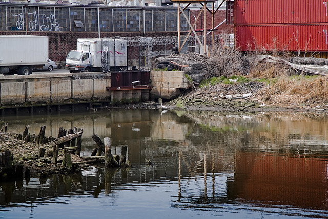
– photo by Mitch Waxman
This place, the very end of English Kills in East Williamsburgh, is non navigable and well beyond the containment boom that is observable from the Metropolitan Avenue Bridge. It hosts a rather large CSO (combined sewer outlet), and is crossed by a rail bridge which connects the massive Waste Management operation to infinite Brooklyn on one side and Queens on the other. The wooden structures which are so pleasingly posed, in their relict decay, are the remains of a former rail bridge which served the same purpose as the modern bridge.
The desk chair above is anybody’s guess.
from habitatmap.org
Combined Sewer Outfall – Newtown Creek 015
- Address Johnson Ave., Brooklyn, NY
- Neighborhood Newtown Creek
- Owner/Occupant NYC DEP
- Location Details Combined Sewer Overflow Outfall NC-015:
- discharges 344.4M gallons per year into English Kills
- Tier 2 outfall
- Ranked 20 out of over 400 in terms of volume
- located at Johnson Ave

– photo by Mitch Waxman
The shores were littered with death and disposal, and I spotted this sad little duck perched out on one of the rail structures. It didn’t seem to be moving very much, and its posture suggested sickness.
The City of New York has plans for this area. Check out page 29 of this PDF
DEP proposes to construct a 9 million gallon CSO storage facility to improve water quality by reducing the CSO discharged into the English Kills during rain storms when the CSO exceeds the capacity of the combined sewers. When this occurs, the CSO would be bypassed to the storage facility. At the end of the rain event the CSO would flow by gravity or be pumped back to the sewer system to be conveyed to the Newtown Creek Water Pollution Control Plant (WPCP) for treatment. This system was recommended by the Newtown Creek Water Quality Facility Planning Project (WQFP), a study that was part of the Citywide Combined Sewer Overflow abatement program.

– photo by Mitch Waxman
Here’s a close up of the duck, which is what I was shooting when my companions and I heard a series of voices and shuffling from the overgrown border of one of the warehouses that abuts the English Kills. Haste was made for a more advantageous position, as we were downhill and the water was at our backs. Strange gutterals were heard emanating from somewhere back in the forbidden brush, a sound almost reminiscent of a dog or bear attempting to speak as a man might- an imitation of speech rather than true use of language.
from epa.gov
Various sediment and surface water samples have been taken along the creek. Pesticides, metals, PCBs, and volatile organic compounds (VOCs), which are potentially harmful contaminants that can easily evaporate into the air, have been detected at the creek.
In the early 1990s, New York State declared that Newtown Creek was not meeting water quality standards under the Clean Water Act. Since then, a number of government sponsored cleanups of the creek have taken place. The New York City Department of Environmental Protection has sampled sediment and surface water at a number of locations along the creek since 1980. In 2009, EPA will further sample the sediment throughout the length of Newtown Creek and its tributaries. The samples will be analyzed for a wide range of industrial contaminants. EPA will use the data collected to define the nature of the environmental problems associated with Newtown Creek as a whole.

– photo by Mitch Waxman
2 men, whose macabre appearance and bizarre style of dress took me aback, emerged from down this trail. Something odd was happening back there, and it was decided that discretion was the best part of valor, and we prepared to exit. Allowing the two men to gain some distance from us (I did not photograph them, out of cowardice) I swung my camera back toward the water and the Waste Management fenceline just as music began to play somewhere back in this wood of suspicion and horror.
from wikipedia
Waste Management, Inc. (NYSE: WM) is a waste management, comprehensive waste, and environmental services company in North America. The company is headquartered in Suite 4000 at the First City Tower in Downtown Houston, Texas, in the United States.
The company’s network includes 367 collection operations, 355 transfer stations, 273 active landfill disposal sites, 16 waste-to-energy plants, 134 recycling plants, 111 beneficial-use landfill gas projects and 6 independent power production plants. Waste Management offers environmental services to nearly 20 million residential, industrial, municipal and commercial customers in the United States, Canada, and Puerto Rico. With 21,000 collection and transfer vehicles, the company has the largest trucking fleet in the waste industry. Together with its competitor Republic Services, Inc, the two handle more than half of all garbage collection in the United States.

– photo by Mitch Waxman
I shot this photo figuring it to be the end of this post, but that’s when I noticed it…
from wikipedia
The eastern half of East Williamsburg, roughly bounded by the Newtown Creek East and by the BQE and Flushing Avenue on the North and South, is mostly zoned for industry with some residential housing mixed among the warehouses and factories. The section is currently referred to by the city as the East Williamsburg Industrial Park (EWIP), or formally the East Williamsburg In-Place Industrial Park (EWIPIP)[8]. The western boundary runs approximately along Kinsgland Ave, then Morgan Avenue and then just East of Bushwick Avenue.
The EWIP is one of eight In-Place Industrial Parks in New York City and is managed by the East Williamsburg Valley Industrial Development Corporation (EWVIDCO), a company founded in 1982 with the goal of revitalizing East Williamsburg by attracting new businesses, providing business assistance to existing firms and grow overall job opportunities in the neighborhood
Historically, this neighboorhood was not part of the Village of Williamsburgh. In the late 1800s the region east of Smith Street (now Humboldt Street), west of the Newtown Creek, south of Meeker Avenue (now the BQE service road)), and north of Metropolitan Avenue was the 18th ward of the City of Brooklyn[10]. The north part of the EWIP is served by the Greenpoint Post Office and is considered by some to be part of Greenpoint. The portion of the EWIP to the South of Metropolitan Avenue was historically part of Bushwick and is still referred by many as being in Bushwick.

– photo by Mitch Waxman
I really have no idea what this is about, and I have read every crackpot theory that has ever been concocted. It very well could just be “ironic” hipster graffiti. I really don’t know, but it’s here at the end of English Kills, where at least two VERY odd characters are camped out. The things I noticed about these two fellows, you see, was this…
Two skinny white guys, late 40’s- early 50’s. Gray hair, both of them. They walked kind of stiff, and they had the colour on them. They lived back there, was my impression. A lot of “down on their luck” people live in these kinds of places- that’s not odd. What was odd- every item of clothing they were wearing still had price tags on them, and their shoes weren’t placed on their feet correctly- one of them had the left foot in the right shoe and so on. It was as if they weren’t used to wearing the clothing of men- or at least the men of this era.
from wikipedia
While it is generally accepted that some homeless people in large cities do indeed make use of accessible, abandoned underground structures for shelter, urban legends persist that make stronger assertions. These include claims that ‘mole people’ have formed small, ordered societies similar to tribes, numbering up to hundreds living underground year-round. It has also been suggested that they have developed their own cultural traits and even have electricity by illegal hook-up. The subject has attracted some attention from sociologists but is a highly controversial subject due to a lack of evidence.
Jennifer Toth’s 1993 book The Mole People: Life In The Tunnels Beneath New York City, [1] written while she was an intern at the Los Angeles Times, is allegedly a true account of travels in the tunnels and interviews with tunnel dwellers. The book helped canonize the image of the mole people as an ordered society living literally under people’s feet, reminiscent of the Morlocks of science fiction writer H.G. Wells.

– photo by Mitch Waxman
As the sign at English Kills says, the one with the little pitchfork in the lower left hand corner:
“In Gods Blessed Darkness Rambo Harnesses Light as Gods Gift to Pain”.
Bigskybrooklyn got some shots of the place during the defoliated winter, which shows a shack back there- check them out.
from nyc.gov
New York City has an estimated 3,306 unsheltered individuals according to HOPE 2008-a ratio of 1 unsheltered homeless individual to 2,485* of the general city population. San Francisco has a 1 in 269 ratio; followed by Seattle with 1 in 295; Miami-Dade County with 1 in 1,741; and Chicago with 1 in 1,798.
There were an estimated 1,263 unsheltered individuals in Manhattan; 279 in the Bronx; 336 in Brooklyn; 135 in Queens; and 152 in Staten Island for a total of 2,165 on the surface (meaning streets and parks). There were 1,141 unsheltered individuals in the subways. Additionally, the Single Adult Shelter Census showed a decline by 19 percent from 8,687 in 2005 to 6,998 in 2008.


