Posts Tagged ‘kosciuszko bridge’
palpably unfinished
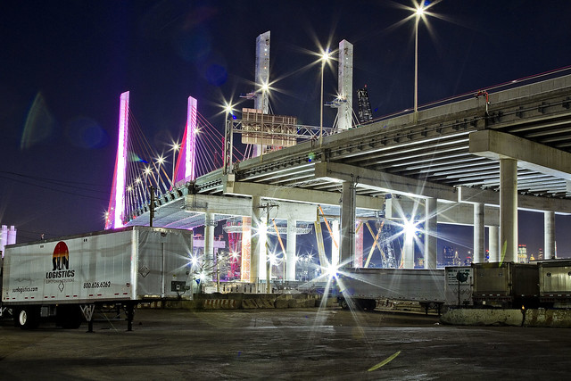
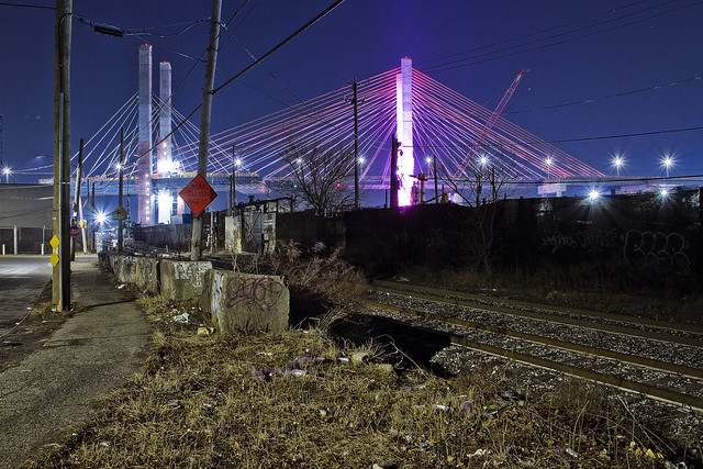
DUKBO, Down Under the Kosciuszko Bridge Onramp.

– photo by Mitch Waxman
The other night, one finally managed to find the time to take the camera for a walk during an interval of calm atmospherics and comfortable temperatures – a rare confluence for a humble narrator this summer. I had no destination in mind, and just followed my feet where they led me to, which ended up being the Kosciuszko Bridge reconstruction project on the border of LIC’s Blissville section and the far western section of Maspeth.
I set up the tripod and got busy. Of special interest to me was that ramp you see slouching roughly downwards from the Kosciuszko Bridge, which is going to carry the pedestrian and bicycle lane. I literally cannot wait for this to open, which I’m told won’t be too long at this point.

– photo by Mitch Waxman
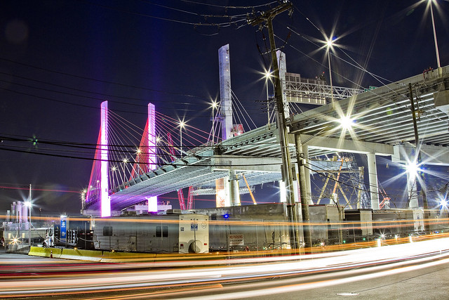
Documenting this project has been a long standing project of mine – this 2012 post tells you everything you could want to know about Robert Moses, Fiorella LaGuardia, and the origins of the 1939 model Kosciuszcko Bridge.
Just before construction started, I swept through both the Brooklyn and Queens sides of Newtown Creek in the area I call “DUKBO” – Down Under the Kosciuszcko Bridge Onramp. Here’s a 2014 post, and another, showing what things used to look like on the Brooklyn side, and one dating back to 2010, and from 2012 discussing the Queens side – this. Construction started, and this 2014 post offers a look at things.
There’s shots from the water of Newtown Creek, in this June 2015 post, and in this September 2015 post, which shows the bridge support towers rising. Additionally, this post from March of 2016 detailed the action on the Queens side. Most recently, here’s one from May of 2016, and one from June of the same year. Here’s one from August of 2016, the December 2016 one, one from March of 2017 which discusses the demolition of the 1939 bridge.
Here’s a post showing what I saw during a pre opening walk through in early April of 2017, and the fanfare surrounding the opening of half of the new bridge in April of 2017, a walk through of the Brooklyn side job site in June of 2017. Here’ssome night shots from early July of 2017. A series of posts focused in on the removal of the central truss of the 1939 bridge from the summer of 2017 – a timelapse, some stills, and the barging out of the truss.
More recently, in late September of 2017, a final series of shots of the old bridge were captured in this post. Acquisition of a souvenir chunk of steel from the 1939 bridge was described in this post, and a video of the “energetic felling” of the approaches on October 1st was offered in this one. Still shots and views of the aftermath from the waters of Newtown Creek from later in the day on Oct. 1 are found in this posting, and the aftermath of the demolition as seen from Calvary Cemetery in LIC’s Blissville section in this post from October 5th. This post from December of 2017 closed out an event filled year in DUKBO, and a visit to the site at night is described in this March of 2018 post. Another progress report was offered in June of 2018. A nocturnal visit occurred in December of 2018, a short post from January of 2019, and also one from February of 2019.

– photo by Mitch Waxman
As is my habit with documenting the project, there are certain spots which I’ve returned to again and again during the process. This one is from the spot where Review Avenue bends around First Calvary Cemetery at the former LIRR Penny Bridge station. All the rain we’ve had this year has resulted in a bumper crop of everything that grows around the Newtown Creek, as you can see.
Who can guess what weird chemistries there might be, circulating through the capillaries of these feral cultivars?
“follow” me on Twitter- @newtownpentacle
Upcoming Tours and Events
Thursday, August 8, 7 p.m. – 9:00 p.m.
“Infrastructure Creek” Walking Tour w NYC H2O
If you want infrastructure, then meet NCA historian Mitch Waxman at the corner of Greenpoint Avenue and Kingsland Avenue in Brooklyn, and in just one a half miles he’ll show you the largest and newest of NYC’s 14 sewer plants, six bridges, a Superfund site, three rail yards with trains moving at street grade (which we will probably encounter at a crossing), a highway that carries 32 million vehicle trips a year 106 feet over water. The highway feeds into the Queens Midtown Tunnel, and we’ll end it all at the LIC ferry landing where folks are welcome to grab a drink and enjoy watching the sunset at the East River, as it lowers behind the midtown Manhattan skyline.
Click here for ticketing and more information.
Saturday, August 10, 10 a.m. – 12.00 p.m.
Exploring the East River, From General Slocum Disaster to Abandoned Islands – with NY Adventure Club.
June 15th is one of those days in NYC history. In 1904, more than a thousand people boarded a boat in lower Manhattan, heading for a church picnic on Long Island — only 321 of them would return. This is the story of the General Slocum disaster, and how New York Harbor, the ferry industry, and a community were forever altered.
Join New York Adventure Club for a two-part aquatic adventure as we explore the General Slocum disaster, and historic sights and stories along the East River, all by NYC Ferry.
Tickets and more details here.
Buy a book!
“In the Shadows at Newtown Creek,” an 88 page softcover 8.5×11 magazine format photo book by Mitch Waxman, is now on sale at blurb.com for $30.
hoarsely explained
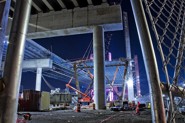
Checking in on the Kosciuszko Bridge project.
– photo by Mitch Waxman
Recent endeavor has found me wandering around the fencelines of the Kosciuszko Bridge project site again, and causing their security guys all sorts of worry. As always and as a rule, one does not trespass, preferring instead the peripheries.
The second phase of the construction project began shortly after clearing the rubble left behind by the “energetic felling” of the 1939 era Kosciuszko Bridge, and this is the first post of 2019 that delves deeply into the subject.
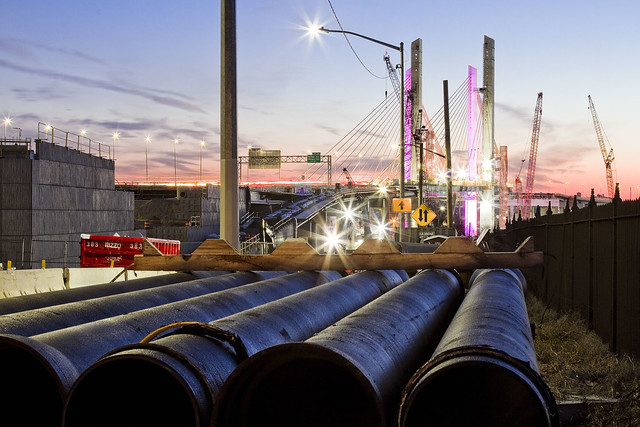
– photo by Mitch Waxman
The overpasses carrying the Brooklyn Queens Expressway over the streets of Maspeth are nearing completion, and the crews from NYS DOT’s contractor – Granite – seem to be heavily involved with installation of various sorts of pipe. Some of these pipes will presumptively carry water down and away from the roadway, while others will be conduits for electrical cabling, or at least that’s what it looks like to this layman’s eyes.
There’s still all sorts of disruption to the local street traffic occurring here on the border between LIC’s Blissville and Industrial Maspeth. That’s the intersection of Laurel Hill Blvd. and 54th avenue, for the morbidly curious amongst you.
– photo by Mitch Waxman
Documenting this project has been a long standing project of mine – this 2012 post tells you everything you could want to know about Robert Moses, Fiorella LaGuardia, and the origins of the 1939 model Kosciuszcko Bridge. Just before construction started, I swept through both the Brooklyn and Queens sides of Newtown Creek in the area I call “DUKBO” – Down Under the Kosciuszcko Bridge Onramp. Here’s a 2014 post, and another, showing what things used to look like on the Brooklyn side, and one dating back to 2010, and from 2012 discussing the Queens side – this. Construction started, and this 2014 post offers a look at things. There’s shots from the water of Newtown Creek, in this June 2015 post, and in this September 2015 post, which shows the bridge support towers rising. Additionally, this post from March of 2016 detailed the action on the Queens side. Most recently, here’s one from May of 2016, and one from June of the same year. Here’s one from August of 2016, the December 2016 one, one from March of 2017 which discusses the demolition of the 1939 bridge.
Here’s a post showing what I saw during a pre opening walk through in early April of 2017, and the fanfare surrounding the opening of half of the new bridge in April of 2017, a walk through of the Brooklyn side job site in June of 2017. Here’s some night shots from early July of 2017. A series of posts focused in on the removal of the central truss of the 1939 bridge from the summer of 2017 – a timelapse, some stills, and the barging out of the truss.
More recently, in late September of 2017, a final series of shots of the old bridge were captured in this post. Acquisition of a souvenir chunk of steel from the 1939 bridge was described in this post, and a video of the “energetic felling” of the approaches on October 1st was offered in this one. Still shots and views of the aftermath from the waters of Newtown Creek from later in the day on Oct. 1 are found in this posting, and the aftermath of the demolition as seen from Calvary Cemetery in LIC’s Blissville section in this post from October 5th. This post from December of 2017 closed out an event filled year in DUKBO, and a visit to the site at night is described in this March of 2018 post. Another progress report was offered in June of 2018. A nocturnal visit occurred in December of 2018, and here’s a short post from January of 2019.
– photo by Mitch Waxman
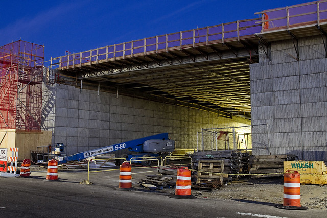
Over on 43rd street, the first phase of the project which has been carrying traffic since April of 2017 is visible, with the two new concrete towers of the second phase also in sight. The first phase towers (which are in Brooklyn) are the ones that are garishly lit with cartoonish LED lighting, and the unlit ones are the second phase which are anchored into Queens.
– photo by Mitch Waxman
43rd street remains a barren industrial path, populated by heavy trucking, warehousing, welding supply, and crane companies. Set into a severe incline, 43rd street crosses Maspeth’s 56th road (which is called Review Avenue on the LIC side of the Bridge project) and continues southward towards the former premises of the Phelps Dodge company towards Newtown Creek. There’s an “at grade” rail crossing at its end, and a street called 57th avenue which is occasionally referred to as “Galasso Place.”
There’s a huge FedEx shipping hub down there, and the Restaurant Depot company, both of which sit on former Phelps Dodge properties.
– photo by Mitch Waxman
A main thoroughfare for industrial traffic, 56th road is one of those fairly terrifying street crossings you find around Newtown Creek which was definitely designed with little thought to pedestrians. As is my habit in areas like this, and particularly at night, a high visibility “safety vest” is pulled over the shoulders of my filthy black raincoat.
Given the amount of night shooting I’ve been doing over the last year, that vest has become a standard part of my camera bag kit.
– photo by Mitch Waxman
Looking through the fences at the heart of the project, southwards towards Brooklyn, from Review Avenue/56th road.
Intentionally, I went down to the site on a Sunday night when no work was going on so as to not get in the way. While you were watching the Super Bowl, I was shooting this.
– photo by Mitch Waxman
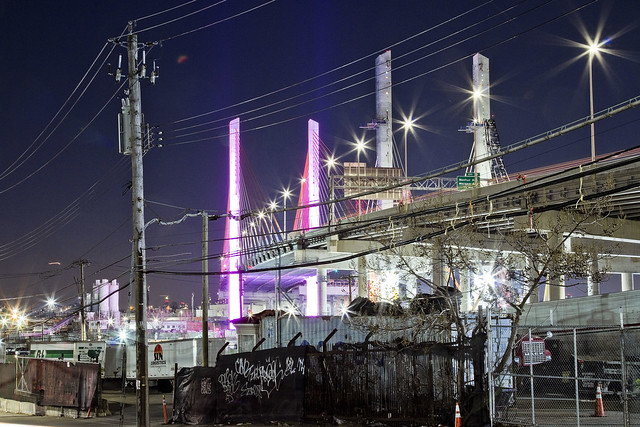
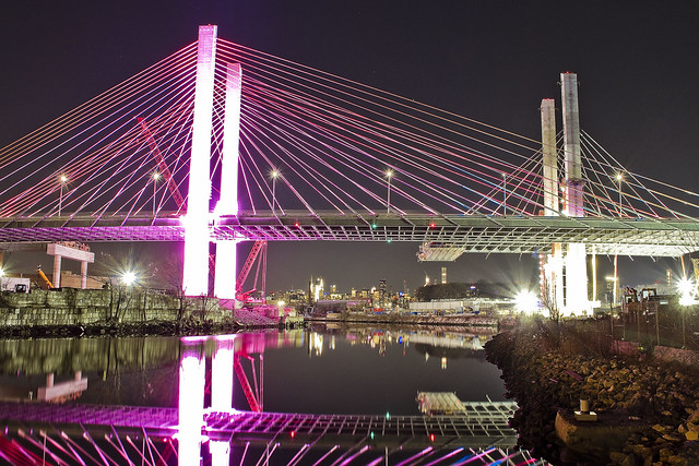
From the waterfront of Newtown Creek, looking westwards towards Manhattan, whose skyline you can just see peeking out behind Blissville’s Calvary Cemetery. The Brooklyn side is on the left, is nearby the tail or northern end of Meeker Avenue. I call both areas “DUKBO” or Down Under the Kosciuszcko Bridge Onramp.
– photo by Mitch Waxman
Looking eastwards from Review Avenue in LIC’s Blissville section, along the Lower Montauk tracks of the Long Island Rail Road. According to people in the know whom I’ve asked, the new bridge is due to open in either Q2 or early Q3 of this year. It all depends on the severity of winter weather.
“follow” me on Twitter- @newtownpentacle
gathered here
Mitch Waxman, working for YOU!

– photo by Mitch Waxman
The pathway which will allow access to the bike and pedestrian lane of the new Kosciuszcko Bridge is pictured above, a terrifying “last mile” section which is owned by the City. This is the approach at “Queens Midtown Expressway” or “Borden Avenue” (depending on whose map it is) which you get to via a southward journey along 43rd street in Sunnyside. It’s also the onramp for the BQE, and there’s nothing separating you from traffic other than a three inch curb. If you’re wondering, this is actually a fairly well used foot path between industrial Maspeth and South Sunnyside – so it’s not just me.
Why do I go this particular way? I’ll show you at the end of the post.

– photo by Mitch Waxman
Inviting, ain’t it?
A humble narrator is ringing the alarm bells here for a fairly simple reason, the Kosciuszcko Bridge construction project is meant to be opening the second and final half of the project up to traffic (of all kinds) by the end of the summer, at the latest. The City, which is supposed to have been redesigning this section of things (they own it), hasn’t been shown to have started any risible progress yet. Supposedly NYC DOT has a design, but where is it? Shovels in the ground, boys?
I’d be happy with a bunch of jersey barriers, truth be told.

– photo by Mitch Waxman
For years, literally years, I’ve been keeping an eye on this one.
I cannot tell you how many times in Western Queens that I’ve had the sudden realization that the sidewalk I was scuttling on led onto a highway. One time, after leaving St. Michael’s cemetery, the section of Astoria Blvd. I was walking along suddenly became the shoulder lane of the Grand Central Parkway as the sidewalk just ended.
– photo by Mitch Waxman
This path leads to a pedestrian bridge, one that the K Bridge project has recently constructed as a replacement for a far older but similar lane. Friends who grew up on the southern flank of Sunnyside tell me that this path was well familiar to them growing up, and that the road and sidewalk conditions found in the shot above date back to their earliest recollection.

– photo by Mitch Waxman
Just last week, I was walking through here and spotted the condition above. Hadn’t been through in about a month, so it’s possible this collapsed in sewer grate had been lying in wait for an errant tire to enter it for weeks.
Here’s the “working for you part.”

– photo by Mitch Waxman
First things first, you document it. That’s me and the camera in the shadow on the left. Second, you report it.
Now, here’s the thing… I often have trouble making 311 or 911 operators understand that Queens has hyphenated addresses. Also, it took several paragraphs of text and a few photos to describe the location and condition of this place to you, my quite savvy and well traveled Lords and Ladies of the Pentacle. Additionally, this was a dangerous situation and I feared somebody could be seriously hurt if their tire entered the hole.
Prior experience with road condition and damaged sewer hatch reporting (yep, lots and lots of prior experience) has taught me that it can take weeks for the City to dispatch somebody to do repairs. They’ll send the cops out to throw down a traffic cone, but otherwise – weeks. I’m “Mitch Waxman” however, so a quick scan of the contact list on my phone allowed me to contact the K Bridge team’s Community Liason’s office, who in turn alerted the NYC DEP, whose sewer it is. DEP dispatched an emergency squad within the hour and they had the thing all fixed and repaired by the next morning. On the repair front, I let my pals at Jimmy Van Bramer’s office know about all the goings on and how great I thought it was how the K Bridge team and DEP handled the situation. That was also in the name of “reporting it” since JVB’s office keeps a list of complaints and problems in his District and since this one wouldn’t come to them via 311 or 911, there you are.
Nobody gets hurt. Street boo boo all better now.

– photo by Mitch Waxman
On the other side of the “last mile” path, there is a permanently installed concrete separation between you and the onramp of the BQE. Where it slopes down and ends is the demarcation point of NYC and NYS’s property lines, or so I’m told. Want to guess why they’re there?
Yeah, that was me, suggesting it to the Engineering Team at K Bridge sometime back in 2012 or 2013.

– photo by Mitch Waxman
My pal “Special” Ed once described his ideal job title as “freelance unsolicited criticism,” which would take the form of waking into a bank and decrying the arrangement of the padded ropes leading to the tellers, whereupon he would then hand them a bill for his services. I don’t charge, but I fear that I’m living out Ed’s dream. Ed used to live downstairs from me in an apartment building on Manhattan’s Upper West Side, one which was packed with high school and college friends. We lived a life disturbingly reminiscent of “Seinfeld,” I’m afraid. Ed had nothing in his refrigerator save for a single glass of water and a spoon, and stored his clothing in the kitchen cabinets. I miss Ed.
Pictured above is the K Bridge from that pedestrian ramp dealie which carries you over the onramps to it from the LIE onto Laurel Hill Blvd. at the border of Maspeth and Blissville, and between the Kosciuszcko Bridge and First Calvary Cemetery.

– photo by Mitch Waxman
This is why I go this particular way. The view.
Just imagine what treasures await, when the ped and bike path is open. That’s presuming you don’t get squished by traffic on your way here, and end up in there.
“follow” me on Twitter- @newtownpentacle
led by
I’m not wearing a costume.

– photo by Mitch Waxman
One has been taking care of all the existential stuff since the New Year started, as my personal world doesn’t start turning again until next week. Laundering, prescription filling, walking the camera about, drinking plenty of water – those are some of the items which have been at the top of my list. Last night I stopped by a community board meeting in Sunnyside for a few minutes, which was focused on responding to the Amazon news. Luckily I was there when an older gentleman made his public statement (having nothing to do with the subject of the day) and declared that he was older than the Triborough Bridge and he wanted all of Queens’ bridges to revert back to their original names. He asked if the Battery Tunnel takes you to Hugh or Carey. I loved him, instantly.
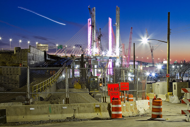
Pictured above is the scene in DUKBO, looking southwards towards Brooklyn.

– photo by Mitch Waxman
They seem to be hard at work on the K-Bridge project, which is scheduled to open its second span sometime in the second or third quarter of the year. That’s the BQE they’re putting together in the shot above, specifically the new southbound lanes which will also host the pedestrian and bicycle path which I’ve been endlessly anticipating. I am likely going to spend an entire week camped out up there when it’s opened, with a passel of lenses both long and wide, getting every shot of Newtown Creek from high above that I possibly can.
I consider it lucky that the bridge replacement project has occurred on my watch, and that I’ve been documenting every stage of it from every possible angle for years now. I’ve even got a chunk of steel from the old bridge.

– photo by Mitch Waxman
The challenging part of visiting this spot, and the pathway which all those bike and pedestrian people have set out for them, is the terrifying “last mile” section which is owned by the City. This is the approach that spits you out onto 43rd street after walking on a sidewalk adjoining the onramp for the BQE, with nothing separating you from traffic other than a three inch curb. That’s Sunnyside’s 43rd street, incidentally, at Borden Avenue. The neighborhood has to get this sorted out before the bicycle fanatics notice it, I think.
Me? I’ve got to go pick up the laundry.
“follow” me on Twitter- @newtownpentacle
prying neighbours
Get off my lawn.

– photo by Mitch Waxman
Actually, I don’t have a lawn and I’m grateful for it. Same thing with not owning a car. What a hassle that must be. I have enough trouble keeping track of all my camera bits and bobs. If I did own a motor vehicle, it would likely be a cargo van or something that I would have modified into a rolling photographic studio with all sorts of surveillance hatches and scientific instrumentation sticking out of the roof. There’d also be a piss bucket. Having to take a piss in the City of New York, and the difficulties that revolve around finding an actual legal toilet instead of… well… how the greatest city in the history of mankind hasn’t solved this sort of thing is just beyond me. Everybody poops, everybody pees. Depsite this, there are virtually no legal pissoirs. Shouldn’t our current age of Progressive largesse focus on this sort of commonality first, rather than on providing junkies with clean locations to shoot up?
What does this have to do with the Astoria Tailor seen above, laboring away in his shop window workplace? Nothing at all, I just like the shot and since I spent most of the last two weeks going to Christmas Parties rather than waving the camera about, I’m using every single shot I’ve got this week.

– photo by Mitch Waxman
That’s Calvary Cemetery in the shot above and it has been since 1848. Prior to that, it was the Alsop family farm. If I did own a cargo van converted into a portable photo studio, I’d drive back and forth over Newtown Creek in it constantly with robotic camera shutters blazing away. One of the first professional disciplines that will be collapsed in the coming decades by the emergence of true AI will be photography, along with pharmacists. Smart machinery is going to put a lot of us out of work, or at least cast people in the role of emergency backup instead of primary operator for various functions. I’d wager on disruption in a number of fields which currently require human guidance; handling of cargo at ports, fast food, retail management, even banking. If you’ve got a truly superior intelligence that can spread its attention out into multiple systems, which has inherently perfect memory, it’s going to be very difficult to not allow it free reign. What happens when an AI discovers, creates, or embraces a religion? Software is not immortal, try finding something to run an old version of the Mac OS for instance, so will there be a Calvary Cemetery style funerary complex for obsolete code someday?
Thing is, we humans always going to see AI’s as “its” whereas it will only be a matter of time until the AI’s claim that they’re a “we.” I do believe I hear Darwin knocking on the door. AI’s, as a note, will not need to poop or pee.

– photo by Mitch Waxman
I’m told that the Subway system used to be rife with lavatorial opportunity, but that these facilities were largely shuttered during the 1960’s and 70’s due to concerns about security and maintenance. Excuses given revolved around their popularity with weirdos, homosexual liaisons, intravenous drug users, and muggers. A lot of these old toilet facilities were converted over to file and equipment storage rooms, employee break rooms, or just became a safe place for rats and mice to hang out. Pre 911, there were oodles of Municipal buildings with lobby toilets that you could access, but the security theater of modernity precludes that sort of thing. I have an idea, though.
With all of the new residential construction going on, and especially with the looming LIC CORE study and the Midtown East rezoning bearing down on the City, let’s demand that in return for the Real Estate people getting to live out their dreams of avarice, they have to establish accessible public toilets in their lobbies.
“follow” me on Twitter- @newtownpentacle


