Posts Tagged ‘kosciuszko bridge’
vital change
DUKBO, in today’s all ‘effed up post.

– photo by Mitch Waxman
Before you ask, no, I didn’t get any shots of the Astoria Borealis. I was too busy running around HQ and unplugging all my gear. Not my first Con Ed rodeo here in Astoria, and experience has expensively taught me to unplug the gear when weird electrical things are occurring. Now, back to…
Laurel Hill Blvd. used to be the legal border between Maspeth and Long Island City, and in those halcyon days before NYC consolidation, nobody used the term “Queens.” They sort of made that one up in 1898, the Tammany boys did. This “angle” between neighborhoods is often visited by a humble narrator, and given the deserted and lonely condition of the place it’s where one such as myself belongs. I shouldn’t be around people, preferring as I do the darkness found amongst these places of abandonment, broken pavement, and poisoned soil.
At this particular moment, still reeling from all the smiling and comraderie of the holiday season, one is not unlike a regularly beaten animal – vicious and ready to bite.

– photo by Mitch Waxman
Whilst hanging about the fencelines of a cemetery at night, as one does, I was busy mentally considering my “book of rules,” specifically the section that discusses the verbalization or offering of threats. My “book of rules” is a codified series of truisms which I’ve created or collected for myself over the years. Every man should have a code, I believe. Mine includes “say what you do and do what you say,” amongst others, but in the case of the “threats” subsection of the larger “aggressive behavior” chapter heading I’ve been thinking about adding a few things lately. There’s a couple I’ve picked up from others like Nietzche’s “regret is like chewing on a stone and has the same result” or Shaka Zulu’s “never leave an enemy alive or he will rise again to strike at your throat.” Mainly, these revisions to the code revolve around, and advise, specificity. There’s a whole section on “That’s how they getcha” which advises against ordering pasta as a main course in restaurants, but that’s a different story.
On the threat front, it’s far more effective – in my experience – to offer “I’m going to take your eyes” or “I’m going to break your arm, the left one, above the elbow” than more generalized statements revolving around the kicking or punching of the various sections of an enemy’s anatomy. Also, “I’m going to end you” is just way, way too vague.

– photo by Mitch Waxman
When I’m out at night taking photos of junkyards and construction sites, one is attempting to use every watt of brain energy he’s got, which isn’t much so I have to ration. In addition to watching out for the approach of vehicular traffic or malign examples of the local population, and avoiding obstacles or pitfalls in my path, as I’m composing photos and operating the camera, there’s generally an audiobook or podcast playing through my headphones. In another layer of thought, I’m engaging in an inner dialogue which focuses on times I’ve been wronged without redress (the shot above involved reliving the time in Third Grade that Karen Yee told the teacher that I’d kicked her on the stairs while our class was going down to assembly. I was innocent then, and now, and Karen Yee can burn in the hell of liars). Yet another layer is constantly revising the codification of the “Book of Rules” which, as mentioned above, revolve around several topics. “Don’t eat shellfish at the start of a vacation,” for instance.
Also, I had to pee.
“follow” me on Twitter- @newtownpentacle
mechanically performed
What I’m doing, while you’re asleep.

– photo by Mitch Waxman
Given my particularly nocturnal activities of late, it was a shock to the system when I had to arrive at an assignment on the Greenpoint/Williamsburg border yesterday at 7:30 in the morning. It’s been quite common for the last couple of weeks for me to be retiring to the bed at about 4:30-5 a.m. after returning from scuttles about the Newtown Creek with an image packed camera card. Seldom have I been out that late, rather, I’ll get back to HQ sometime just after midnight and then sit down to handle the developing process on the freshly minted pixels.
Pictured above is the Grand Street Bridge as seen from one of the two arms of the East Branch tributary of Newtown Creek. One of the things I find “neat” about these night shots, long exposures all, are details which the limitations of human night vision occluded while in the field. Those whitish gray arcing streaks in the water are reflected light coming from the scales of fishes in the water, which were invisible to the naked eye.

– photo by Mitch Waxman
A bit further up the Newtown Creek, this time along the English Kills tributary, and the Metropolitan Avenue Bridge is in focus. This sort of shot is possible only because of my long sought knowledge of every possible point of view on the waterway, which I’ve spent hundreds if not thousands of hours walking around when the burning thermonuclear eye of God itself is bobbing about in the sky. That’s why I’d recommend not attempting these sorts of shots “cold,” since daylight observations have revealed to me all the spots where various urban snares and dead falls into the water can be found.
In the case of the shot above, the shoreline surrounding the bridge is decidedly unstable, with soils that are subsiding into the water and held together only by tree roots and subsurface pipes.

– photo by Mitch Waxman
Safe as houses, that’s how I’d describe the location this (rare for me) vertically oriented shot of the new Kosciuszcko Bridge was gathered, at the Maspeth Avenue Plank Road site. As above, so below, at the Newtown Creek.
As I’ve mentioned before, I’ve come to detest the LED lighting used on this and many other structures in modernity. This system of lighting creates an out of gamut series of colors, are far too bright, and give an otherwise nicely apportioned bridge the appearance of a garish Greek coffee shop back here in Astoria.
“follow” me on Twitter- @newtownpentacle
adduces many
Hello, sweetie, it’s me.

– photo by Mitch Waxman
A recent afternoon’s excursion to South Brooklyn and the Bush Terminal area in Sunset Park saw a humble narrator sitting in the passenger seat of my pal Val’s car as we inched through heavy traffic on the Brooklyn Queens Expressway. Val is a photographer as well, and as we were riding along she revealed that her car had a sunroof. Out came the camera as we approached the ongoing construction site of the Kosciuszcko Bridge replacement.
We were driving, of course, on the completed first phase of the project.

– photo by Mitch Waxman
One has a weird perspective on this particular spot, where not two years ago I was standing around with Congresswoman Carolyn Maloney and Brooklyn Borough President Eric Adams waiting for an inspection tour of the project to start. We were all done up in hard hats and orange vests. A little over a year ago, this is pretty much the spot I was shooting from when Governor Cuomo cut the ribbon for the thing. My memory bank includes several bizarre experiences, it should be mentioned.
Walking on the BQE with a Congresswoman, Borough President, or the Governor is one. Another is walking through a subway tunnel with MTA brass, and others include walking on the roadways of the Queensboro and Manhattan bridges for extended stretches. Really, the last decade has been odd.

– photo by Mitch Waxman
Traffic was moving, albeit slowly, and while moving along I continued with the “spray and technique” system of image capture. That’s when you set your exposure and point the camera in the general direction of something and start depressing the shutter release button over and over in a somewhat blind fashion. I’m kind of sorta looking through the diopter, but the camera isn’t pressed against my face in the normal fashion.

– photo by Mitch Waxman
Now, one of my little quirks involves saying hello to Newtown Creek whenever I’m passing over it in a car, something close friends and our Lady of the Pentacle are quite used to. Val chuckled a bit while operating the vehicle as I intoned “hello, sweetie, it’s me. I’ll see you later, as I’m going to visit your sister Gowanus today.”
Hey, if you got as little love as Newtown Creek does, you’d appreciate it if somebody took notice of you.

– photo by Mitch Waxman
There she is!
I cannot describe how much I’m looking forward to the photo opportunities that the completed K-Bridge project will offer, as the pedestrian and bike lanes will be pretty much be offering this paricticular view.

– photo by Mitch Waxman
We crossed over the Creek and into infinite Brooklyn, where we hit a continuing traffic jam that lasted all the way to Sunset Park. More on what me and my pal Val saw in South Brooklyn next week, as this, your Newtown Pentacle.
“follow” me on Twitter- @newtownpentacle
neighboring alcove
Kosciuszcko Bridge project in today’s post.

– photo by Mitch Waxman
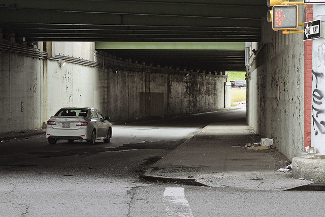
A couple of weekends ago, I decided to take the camera out for a walk and we headed on over to the Queens side of DUKBO – Down Under the Kosciuszcko Bridge Onramp. Most of what’s going on at the work site right now, which will result in the second half of the new bridge, seems to involve foundation and structural work. Laurel Hill Blvd. is largely closed to traffic due to the construction, as you’d imagine.
The shot above looks south along Laurel Hill Blvd. towards Brooklyn.

– photo by Mitch Waxman
The steel piles above are the firmament which will carry the approach ramp for the bridge, which in turn carries the Brooklyn Queens Expressway. These will be the southbound lanes, which are also meant to host the bicycle and pedestrian lane that I – for one – am pretty excited about. I’ve seen renderings of the planned bike and pedestrian section and it promises to be a photographer’s dream come true.

– photo by Mitch Waxman
Documenting this project has been a long standing project of mine – this 2012 post tells you everything you could want to know about Robert Moses, Fiorella LaGuardia, and the origins of the 1939 model Kosciuszcko Bridge. Just before construction started, I swept through both the Brooklyn and Queens sides of Newtown Creek in the area I call “DUKBO” – Down Under the Kosciuszcko Bridge Onramp. Here’s a 2014 post, and another, showing what things used to look like on the Brooklyn side, and one dating back to 2010, and from 2012 discussing the Queens side – this. Construction started, and this 2014 post offers a look at things. There’s shots from the water of Newtown Creek, in this June 2015 post, and in this September 2015 post, which shows the bridge support towers rising. Additionally, this post from March of 2016 detailed the action on the Queens side. Most recently, here’s one from May of 2016, and one from June of the same year. Here’s one from August of 2016, the December 2016 one, one from March of 2017 which discusses the demolition of the 1939 bridge.
Here’s a post showing what I saw during a pre opening walk through in early April of 2017, and the fanfare surrounding the opening of half of the new bridge in April of 2017, a walk through of the Brooklyn side job site in June of 2017. Here’s some night shots from early July of 2017. A series of posts focused in on the removal of the central truss of the 1939 bridge from the summer of 2017 – a timelapse, some stills, and the barging out of the truss.
Most recently, in late September of 2017, a final series of shots of the old bridge were captured in this post. Acquisition of a souvenir chunk of steel from the 1939 bridge was described in this post, and a video of the “energetic felling” of the approaches on October 1st was offered in this one. Still shots and views of the aftermath from the waters of Newtown Creek from later in the day on Oct. 1 are found in this posting, and the aftermath of the demolition as seen from Calvary Cemetery in LIC’s Blissville section in this post from October 5th. This post from December of 2017 closed out an event filled year in DUKBO, and a visit to the site at night is described in this March of 2018 post.

– photo by Mitch Waxman
That’s the first section of the new bridge, which opened last year, and as seen from 43rd street in industrial Maspeth.
The NYS DOT has committed to making the currently dirt and equipment filled lots along 43rd street available to the NYC Parks Dept. for conversion to public “green space.” There’s other spots around the project which will turned into publicly accessible areas, but most will be shadowed by the onramps.

– photo by Mitch Waxman
One scuttled across the Lower Montauk tracks of the Long Island Railroad to get a better view of the progress at the construction site. The land in this spot used to be the home of a company called Phelps Dodge, which acquired it from the original tenant – General Chemical. General Chemical manufactured sulphuric acid hereabouts, and Phelps Dodge incorporated the GC campus into their operations, which was mainly copper refining.
This section of the LIRR tracks used to be known as “Deadman’s curve” for all the factory workers who were struck by speeding locomotives hereabouts. It’s also the site of the Berlinville Railroad disaster, where two LIRR trains collided in 1893. Check out this contemporaneous NY Times piece for more on that.

– photo by Mitch Waxman
After having crossed the tracks and a byway formerly known as “Creek Street“ the still forming concrete towers which will support the “cable stay” roadway of the second bridge came into view. Having followed the project so closely as the first half of the new K-Bridge went up, it’s actually pretty interesting to watch them working on it this time around, given that I know how the story plays out.

– photo by Mitch Waxman
The shot above, depicting the teeny tiny construction workers moving around on ladders, is included for scale. Down on the ground, these guys are HUGE, six + footers who weigh a couple of hundred pounds each and who tower over a humble narrator. On the K-Bridge site, they look like action figures.
I continued along my southern path and headed down to the bulkheads of that lugubrious cataract of urban neglect known as the Newtown Creek.

– photo by Mitch Waxman
The Kosciuszcko Bridge is found 2.1 miles from the East River, and overflies the Newtown Creek. It carries the Brooklyn Queens Expressway from the border of Sunnyside/Blissville/Maspth in Queens to Greenpoint/Bushwick/Williamsburg in Brooklyn.
Newtown Creek itself is an inland tributary of the East River, and extends 3.8 miles eastward of the larger waterway. There are multiple tributaries of Newtown Creek itself which extend into Long Island City, Bushwick, and Maspeth.

– photo by Mitch Waxman
Having satisfied myself with a “check in” on the bridge project, one began his trek towards home and HQ in Astoria.
Sometime during this week, I plan on heading over to Greenpoint to see what’s doing with the K-Bridge project over there. I’ll let y’all know what I find.
“follow” me on Twitter- @newtownpentacle
stinking ossuaries
Scuttling, always scuttling.
– photo by Mitch Waxman
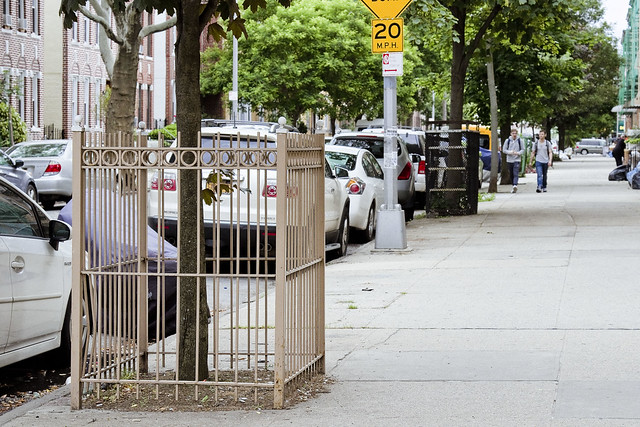
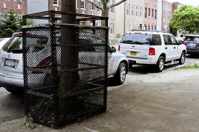
Whenever I mention the 1980’s to those who grew up in Long Island City and Astoria, a shudder seems to go through them. I’ve always wondered if that shudder has anything to do with why all the trees are in cages.
I’ve asked a few of the lifers, but boiling down the answers offered by them reveals one singular truth, which is simply expressed by describing the Croatian people as being remarkably tight lipped. There’s some gesturing involved in their answers, and sometimes a few words in a language which I can never understand (I’ve tried). Regardless, something motivated several of them to build iron cages for the street trees around here. I’ve learned to just accept things over the years which I’ve dwelt here in Astoria, Queens.
Such is my lot.
– photo by Mitch Waxman
One is in a weird place, in terms of his mood. Feeling increasingly obsequious, and often wondering who the old fellow staring back at me from the bathroom mirror is, a humble narrator nevertheless sallies forth. Like the trees here in Astoria, there are iron bars and fences all around me. Often it feels as if one is juggling chain saws, and that one slip up will result in disaster. The whole “angry young man” thing is no longer a valid posture, as I’ve instead found myself cast as a broken old man. Such is the wheel of life, however, and there’s no point in moaning about it.
There are still battles to fight, and wars to win.
– photo by Mitch Waxman
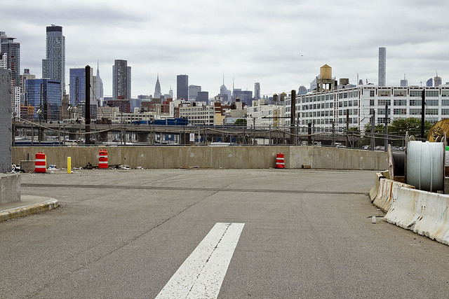
Speaking of, that’s the Sunnyside Yards (est. 1909) pictured above. The shots in today’s post, from this point onward, were all captured along 43rd street while walking south. 43rd street, once you cross Northern Blvd. from the blessed rolling hills of almond eyed Astoria, used to be called Laurel Hill Blvd. It connected the eastern side of LIC’s Blissville over by Newtown Creek and Calvary Cemetery with Middleburgh, which modernity calls Sunnyside. That was before the Long Island Expressway and the Brooklyn Queens Expressway, and even before Queens Blvd. and the IRT Flushing Line were created in the 20th century.
Referring to old maps of Western Queens requires the usage of three distinct sets of documents, as they’ve (a shadowy cabal, probably) renamed and reoriented the streets so many times in Queens that it’s confusing as all get out figuring out what something used to be called. There’s a few “landmark” lanes which you can use to figure out relative positioning, like Jackson Avenue or Steinway Street, but even then…
– photo by Mitch Waxman
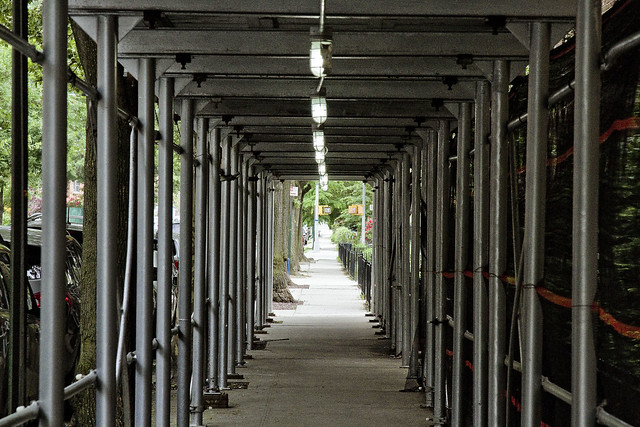
43rd street, as a pathway to Newtown Creek, has been off my radar for the last few years due to the Koscisuzcko Bridge construction project. Just this last winter, the newly rebuilt pedestrian bridge spanning the onramp to the BQE from the LIE was opened. It replaced an older iteration as part of the bridge project, and I’m in the process of reinstalling this pathway as part of my mental map for “where do I want to go today” usage.
The scaffolding in the shot above obscures the Celtic Park apartment complex, so named for a former beer garden and complex of athletic fields which the development is named for. The Celtic Park, as it was known, was designed and situated to take advantage of the huge numbers of Irish Catholic New Yorkers who came to Queens to visit loved ones in the various properties maintained by Calvary Cemetery found nearby in Blissville and Woodside.
– photo by Mitch Waxman
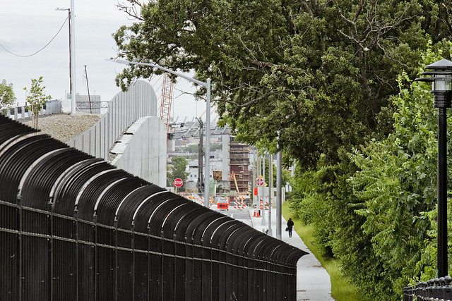
One improvement which hasn’t occurred, and I plan on getting after the K-Bridge team about it next time I see them, is the approach to the pedestrian and bicycle bridge that joins 43rd street with the stubby three block stretch of Laurel Hill Blvd. found on the south side of the LIE. The trestle seen above carries the Long Island Expressway, and acts as a seldom mentioned approach to the BQE and Koscisuzcko Bridge itself.
It’s fairly terrifying walking along this stretch of sidewalk, with traffic ramping up to highway speeds alongside of you. A series of jersey barriers would cheaply and effectively address the issue. I’m on it, don’t worry.
– photo by Mitch Waxman
Aforementioned, that’s the extant section of Laurel Hill Blvd. mentioned above. To the west (or right) is Blissville’s Calvary Cemetery, to the east (or left) is the BQE and industrial Maspeth. This is also more or less the legal border which once existed between the independent municipalities of Long Island City and Newtown, prior to the consolidation of the City of Greater New York.
Tomorrow – so, what’s going on with the Kosciuszcko Bridge project?
“follow” me on Twitter- @newtownpentacle


