Posts Tagged ‘New York City’
grassy cobbles
Monday

– photo by Mitch Waxman
Last week, one described the circumstances of a navigation of Newtown Creek on September 27th during which the photos in today’s, and prior postings, were captured. The small boat I was riding in had been navigated all the way back to the Metropolitan Avenue Bridge by it’s Captain – Carter Craft. There’s still a bit of navigable water beyond this span, a double bascule drawbridge owned and operated by the NYC DOT, but I seldom go back there in anything larger than a rowboat and I don’t do that often at all.
Down Under the Metropolitan Bridge Onramp or DUMABO, that’s how I “tag” anything which I’ve written about this bridge, or the area directly surrounding it in Brooklyn. The English Kills tributary of Newtown Creek is entirely contained within the political boundaries of the Borough of Brooklyn, in its East Williamsburgh section.

– photo by Mitch Waxman
English Kills is entirely hidden from view on the surrounding streets. A once natural waterway canalized by the various Corporate entities which once housed themselves here, and the United States Army Corps of Engineers. From the surrounding streets, you’d never know it was there if it wasn’t for the industrial noises and horrific smell. The odor is not unlike what you’d expect were you were to shit into a bucket of rubber cement thinner, and then set it out to sit in direct sunlight, while a running diesel engine out gassing exhaust. The sound is a “constant din” as in there’s no specific point source for it, rather there’s an atmosphere of noise echoing off the factory and warehouse walls.
The canalized shape of English Kills follows the jigsaws grid of the surrounding streets, which causes its waters to stagnate around the right angled turns. The presence of CSO’s – or Combined Sewer Outfalls – all along Newtown Creek means that the only fresh water entering English Kills comes from these upland drains. This flow is a mix of storm water, road runoff, and sewage. The latter is full of piss and poop, if you need me to point that out. The runoff and storm water washes through the neighborhoods first, carrying garbage and whatever might have dripped out of vehicles passing by on the roadways, and then into the stagnant water column of the tributary.
Because of the stagnation, a bed of sedimentation sits 15-20 feet thick under the surface of the water, sometimes poking out into the air at low tide. The sediments are referred to as “Black Mayonnaise.”

– photo by Mitch Waxman
Historic records suggest that the natural waterway that was once here, prior to colonization by the Dutch, was fed by upland streams and rock springs running down into the waterway’s basin from the highlands surrounding it, in modern day Maspeth, Ridgewood, and Bushwick. It’s the availability of that fresh water bubbling up from the rock springs that drew German beer breweries to establish themselves in these areas. The springs were capped, and the ground water claimed. That was the first industrial nail in the coffin of this part of the larger waterway. Contaminants and pollution from industrial plants literally miles away on the Creek would end up getting pushed back here and since there was nothing tidally pushing back, the bad stuff settled to the bottom. The Black Mayonnaise encountered “here” can be very different from conditions encountered “there,” despite the fact that it’s the same water body. Even on English Kills, the section you’re looking at in the shot above is entirely different from the hellscape found a half mile away in the zone around the apocalyptic Montrose Avenue Railroad Bridge nearby Newtown Creek’s terminus, at Bushwick’s Johnson Avenue.
Few of the modern businesses on English Kills use their maritime bulkheads, once amongst the most valuable in NY Harbor or even the world due to the nearby Evergreen Line Railroad tracks – which are today’s Long Island Railroad Bushwick Branch tracks.

– photo by Mitch Waxman
Open sewers dating back to the Civil War are seen here.
English Kills is the extermination of ration and hope, and a cautionary tale about municipal indifference. The NYC DEP, who operate those CSO drains mentioned above, found themselves under regulatory scrutiny by New York State a few years ago due to the low levels of oxygen present in these waters. The low oxygen situation is caused by sewage bacteria, which they allow into the Newtown Creek via the CSO’s. The answer DEP came up, since doing anything at all about the outflows themselves would be very expensive to the City, was to instead build an aeration system into the waterway. Giant bubble wands, reminiscent of a hobbyist aquarium’s setup, pump air into the water, which causes surface turbulence. These bubbles theoretically cause atmospheric oxygen to diffuse into the water.
The air flow also introduces mechanical energy into the bottom sediments and causes them to rise and coat the shorelines, where the so called black mayonnaise becomes exposed to the air.

– photo by Mitch Waxman
Grand Street Bridge, a swing bridge, is pictured above. The center of that bridge is where the currently undefended border of Brooklyn and Queens is found. If hostilities ever break out, this will be a flash point and no man’s land where campaigns of armed attrition will play out.
Our time on Newtown Creek was nearing an end and my pal Carter captained us back toward Greenpoint, and the Manhattan Avenue Street End where he picked us up earlier in the day. A humble narrator was on an emotional roller coaster, it should be admitted.
“Every time might be the last time.”

– photo by Mitch Waxman
Along our journey back in the direction of the East River, nearly three miles back on the Maspeth side, we saw a guy fishing in Newtown Creek.
Tomorrow, more! And then even more! More all the time, now with extra more! Now – more than ever – more!
“follow” me on Twitter- @newtownpentacle
Buy a book!
“In the Shadows at Newtown Creek,” an 88 page softcover 8.5×11 magazine format photo book by Mitch Waxman, is now on sale at blurb.com for $30.
formal blessing
Wednesday

– photo by Mitch Waxman
“Every time might be the last time,” I keep saying. On the 27th of September, one was traveling during the late morning to Brooklyn’s Greenpoint section. Specifically, I was heading for the Manhattan Avenue street end. An appointment was involved, and to ensure my timeliness the Subway was invoked.
Moving through the transit portals I do, one inevitably found himself over at the MTA’s Court Square facility, and the G line subway.

– photo by Mitch Waxman
A brief ride, and then one found himself in Greenpoint itself. The MTA has recently installed an elevator system in this station.
Its signage caught my eye.
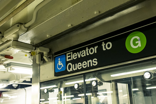
– photo by Mitch Waxman
That must be some elevator, thought I.
Since I like using things I’ve helped pay for, I hit the button and had a funny exchange about the improvement with another commuter, whose personal invective was framed by English spoken with a syrupy Polish accent. Ahh, Greenpoint, how I’ll miss the default state of sarcasm that you inspire, and that I always enjoy interacting with, in your residents.
– photo by Mitch Waxman
One scuttled down hill along Manhattan Avenue, towards the fabulous Newtown Creek.
“Every time might be the last time,” and this time around, I was meeting up with a friend that owns a boat. He offered to take me out for one last “from the water” photo session on my beloved Creek.

– photo by Mitch Waxman
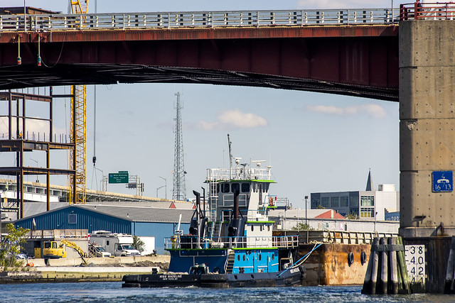
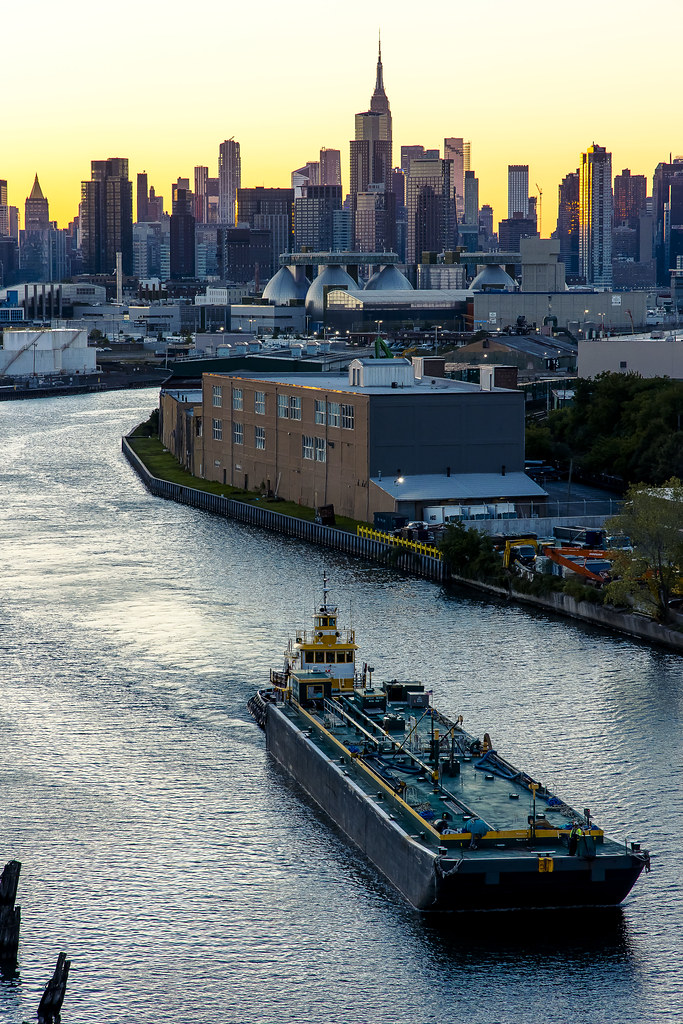
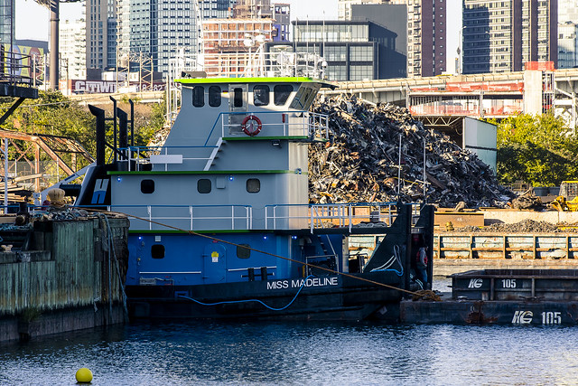
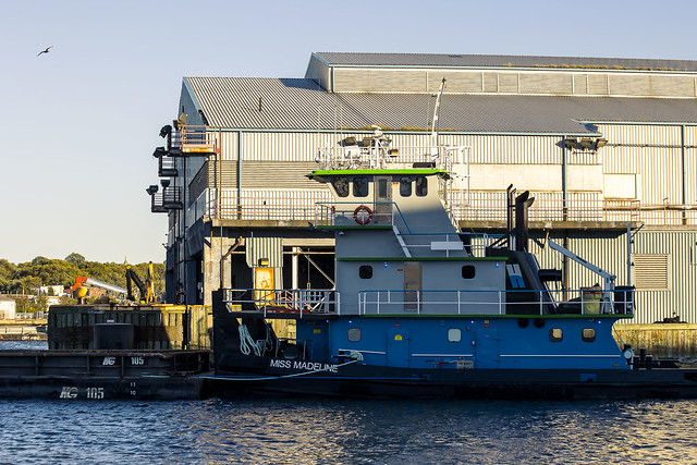
While I was waiting for him to arrive, the tug Miss Madeline reappeared in front of the camera.
Just a few days ago, shots of the selfsame vessel attempting to conquer the laws of physics and mechanical engineering were offered here.
– photo by Mitch Waxman
Tomorrow – I’ll show you what I captured on this particular day.
Miss Madeline navigated under the Pulaski Bridge, as we soon would.
More tomorrow.
“follow” me on Twitter- @newtownpentacle
Buy a book!
“In the Shadows at Newtown Creek,” an 88 page softcover 8.5×11 magazine format photo book by Mitch Waxman, is now on sale at blurb.com for $30.
tenebrous others
Tuesday

– photo by Mitch Waxman
On the 26th of September, one perpetrated a short scuttle around a long set of railroad fence lines. A hurricane was tearing up Florida, and we got lucky hereabouts in terms of spectacular skies for about a week. Eventually, NYC was going to get hit with 6 or 7 dreary rain days due to the weather system, but on the evening of the 26th it was perfect photo weather, so off I went.
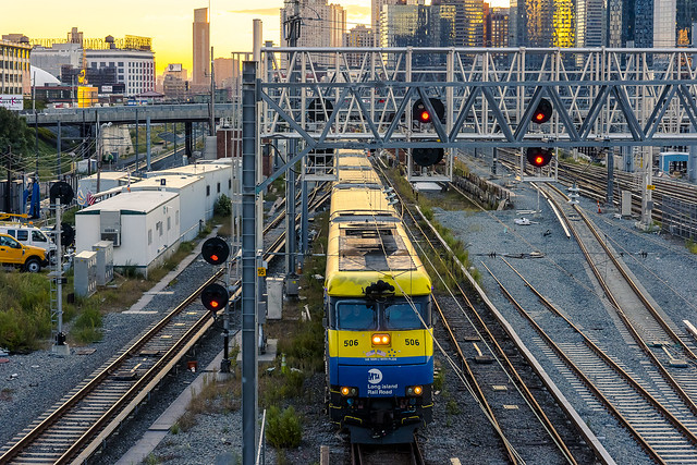
A humble narrator crossed Northern Boulevard out of Astoria heading south along 39th street – aka the Harold Avenue truss bridge over Sunnyside Yards.

– photo by Mitch Waxman
Progress was made towards “hole reliable,” a surveyor’s POV cut into the steel plate fences of the rail coach yard. There’s actually two holes there, reliable and “hole alright.” The shot above is from the alright one. It’s inferior to reliable because of that metal bar in the foreground. Reliable? Unoccluded!
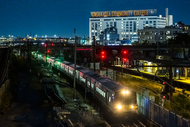
That’s the Long Island Railroad, heading towards the City, at the Harold Interlocking. This is one of the top ten bits of infrastructure in New York City, in terms of importance on a National level.
– photo by Mitch Waxman
An LIRR train set heading eastwards and away from the City.
What makes Harold Interlocking so important is the commuter rail, pictured above, which connects Nassau and Suffolk Counties to the five Boroughs of NYC. What makes it even more important is Amtrak’s Northeast Corridor service used to share this route. Amtrak moves north bound trains through a tunnel under the East River, then emerges at Sunnyside Yards, travels through the yards to the New York Connecting Railroad, and then over the Hell Gate Bridge. This Harold Interlocking is one of the strategic pinch points in our National system, which is the sort of thing that should make the Homeland Security crowd unable to sleep at night.

– photo by Mitch Waxman
One of the wonders which I’ve been privileged to get a LOT of photos of is due to the discovery of Hole Reliable. Since 2009, the East Side Access project has included an incredible amount of construction work at Sunnyside Yards. Part of that has been the addition of additional tracks here at Harold. Yeah, I know, I’m a nerd.
Saying that, a derailed LIRR train no longer shuts down rail traffic on the East Coast of the United States within a couple of hours as Amtrak’s resultant “situation” ripples out of Queens. LIRR service is fairly frequent, and actuaries will describe a predictable number of annual incidents of every type to prepare for – including derails.
– photo by Mitch Waxman
One scuttled down Skillman Avenue and headed for the 7 train station at Hunters Point Avenue. On my way, yet another LIRR train was spotted, this one heading towards Manhattan.
As mentioned, short walk for me. A constitutional during which I cracked out a bunch of photos. Managed to find about 90 minutes or so to stretch my legs, in the midst of all the tumult back at HQ. Moving is always stressful, and you lose all sense of comfort at home due to constant “have to” and stacks of boxes. Also, there’s always something to do. Never ends.

– photo by Mitch Waxman
The 7 train arrived, one boarded it, and whereas my plan was to linger around Queensboro Plaza for a bit while waiting for the N to arrive, my intended ride was arriving just as I did. Not wanting to look a gift subway in the mouth, I quickly transferred and headed back to HQ.
I had kind of a big thing coming up the next morning, after all.
More on that tomorrow.
“follow” me on Twitter- @newtownpentacle
Buy a book!
“In the Shadows at Newtown Creek,” an 88 page softcover 8.5×11 magazine format photo book by Mitch Waxman, is now on sale at blurb.com for $30.
times amidst
Monday
– photo by Mitch Waxman
A long walk continues! From Astoria to LIC’s Blissville, and then looping around and through Brooklyn’s Greenpoint section, on the 23rd of September of 2022. “Every time might be the last time…”
Scuttling along the hoary asphalt, which armors the oil choked loam of this ancient outpost of the decadent Dutch, a humble narrator suddenly realized that both altitude AND declination were warping, as he had blindly wandered onto those entirely euclidian angles which are offered by the New York State Department of Transportation via the bicycle and pedestrian pathway of the Kosciuszcko Bridge which said agency maintains.
Thoroughly modern in both function and design, the Kosciuszcko Bridge(s) nevertheless are visually pleasing to me – a barren creature, broken and bruised, bereft, bankrupt and often beleaguered – your always humble narrator. The Kosciuszcko Bridge carries, in addition to the path one scuttled atop, the Brooklyn Queens Expressway, and its teeming multitudes of automotive wanderers, high over the iridescent waveforms of an aqueous ribbon of urban neglect which is known, to modernity, as the Newtown Creek.

– photo by Mitch Waxman
The burning thermonuclear eye of God itself was descending behind New Jersey, just as the monocular of the camera was being moved into position high over the jellies and tepid currents of said waterway. One actuated the shutter button again and again while shuffling along…
It has been years since one has spoken to you, lords and ladies, in this sort of way. Colloquial verbiage and easy conversational voicing has been my intent in recent intervals. Nearing the end of all things, and the shadowy beginnings of a new chapter, one instead feels a deep desire to revisit the past. To plumb the depths.
Always have I been an outsider, attracted to things ancient and unloved.
– photo by Mitch Waxman
Who can guess, thereby, all that might be buried down there – beneath the waters buoying that tugboat? What foul truth might lurk, concealed in the black mayonnaise which sits patiently along the bottom of the glacier carved ancestral valley that Newtown Creek floods and calls its bed?
The “bad water place” is what one of the Lenape words for the Newtown Creek is said to translate into English as. That, and those, who are rumored to dwell in the broken stone floor of the nearby Hells Gate section of the East River, might know other words. Perhaps, and perhaps not. I’ve likely said too much.
Let’s change the subject… how about that sports ball team hereabouts? Might this be finally the year of affirmation for our civic and mutual worth, displayed to the globe by champion status in sports ball?
– photo by Mitch Waxman
The locale of the forbidden colony of New Arnheim, detested and personally destroyed by the Dutch Governor Peter Stuyvesant, is not too far away from this spot, just east and towards the Brooklyn side. So too is the forgotten Blissvillian tributary of Wolf Creek, and the overwhelming necropolis called Calvary Cemetery.
The latter hosts its own storm sewer and drainage systems, whose horrifying outflows into the Newtown Creek are not just splendiferous in coffin varnish, adipocere, and formaldehyde. The black mayonnaise underlying the waters here are rich with acrylonitrile concentrations – according to environmental scientists. Toxic, certain groupings of this type of organic chemicals are commonly referred to as “cadaverine” and “putrescine.” This and many other reasons underlie the presence of signage around this waterway adjuring the citizenry against consuming fish or crabs captured from its volume.
This outflow pipe for the cemetery is found directly below the railroad tracks in the photograph above, which are upon the former site of the Penny Bridge crossing demolished in 1939, and a former Long Island Railroad stop also called Penny Bridge which was eliminated by the MTA under mysterious circumstance in 1998. This is the part of Newtown Creek where hauntings of the Blissville Banshee were oft reported.
– photo by Mitch Waxman
Horror lurks everywhere along Newtown Creek. Approximately 170,000 vehicle trips cross the Kosciuszcko daily, as reported by Governmental agencies knowledgable about such statistical data. One wonders… statistically speaking, how many times a day does a murderer cross the bridge? Figure there’s two people in every car… how many murderers are there per hundred thousand New Yorkers?
As above, so below?

– photo by Mitch Waxman
One found his way back down to the poison ground, alongside First Calvary Cemetery, and its tomb legions, at the outskirts and border of both Blissville and ancient Maspeth, in Queens. The camera’s functional optics were swapped out, and a quick conversion over to the “night kit” was effected. The “daylight” zoom lenses were stored away, and my next steps considered. Into the darkness, yes, but which pathway?
Ahem… truth be told, my feet were hurting at this point so I just called a cab and headed back to HQ in Astoria. I had another busy couple of days coming up, and…
More tomorrow, at this – your Newtown Pentacle.
“follow” me on Twitter- @newtownpentacle
Buy a book!
“In the Shadows at Newtown Creek,” an 88 page softcover 8.5×11 magazine format photo book by Mitch Waxman, is now on sale at blurb.com for $30.
voyages incalculable
Friday
– photo by Mitch Waxman
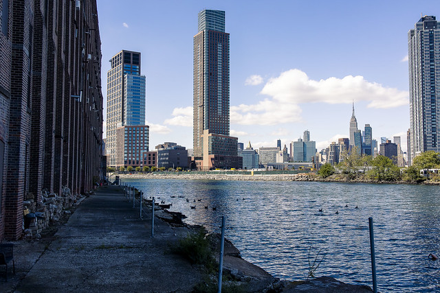
A humble narrator was accomplishing a longish scuttle on the 23rd of September, one which saw me perambulating from the rolling hills of almond eyed Astoria in Queens towards the concrete devastations of the lugubrious Newtown Creek and the Greenpoint section of Brooklyn. Pictured above is the view from mid span on the Greenpoint Avenue Bridge.
“Every time might be the last time.” That’s my mantra at the moment, and thereby I’m trying to visit everywhere one last time.
– photo by Mitch Waxman
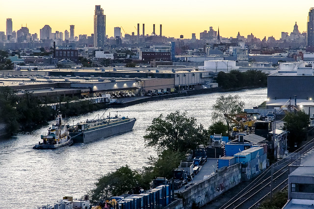
At the poetically named “Unnamed Canal” along Newtown Creek, I spotted the tug Miss Madeline struggling a barge against an incoming tide flooding in from the East River. There’s a bit of laminar or horizontal tidal movement in this section of Newtown Creek, whereas in other areas – notable the tributaries like Dutch Kills and Maspeth Creek, where tidal action is discernible only in a strictly vertical form.
Everybody tells me that I’ll be coming back to NYC within two years. This is extremely unlikely. If things go badly for me in Pittsburgh, Our Lady of the Pentacle and myself will just move on to the next place, or the one after that. I’m sure that there will be occasional visits here for work or extended family events, but my residence will be elsewhere.
– photo by Mitch Waxman
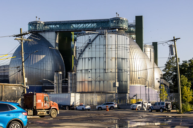
Hey, it’s the New York City Department of Environmental Protections’ Newtown Creek Resource Recovery and Wastewater Treatment Facility pictured above. Can you imagine being the person who answers the phones there? Due to my influence, everybody associated with the various Newtown Creek community groups have just started using “the sewer plant in Greenpoint” instead. Give DEP five years and they’ll have probably inserted the first stanza of “T’was the night before Christmas” into the place’s name by then. Jeez.
My next destination was the Newtown Creek Nature Walk, which was funded under the NYC Charter requirement known as “1% for art.” The stipulation commands NYC to commit one percent of the budget of any new municipal construction project to either public open space or to a work of public art. Phase 2 & 3 of this Nature Walk was a project which a humble narrator was deeply involved with, as a member of the community oversight “Newtown Creek Monitoring Committee” or NCMC. I ended up putting in a lot of hours for this one.
– photo by Mitch Waxman
From Phase 1 of the Nature Walk, one observed Miss Madeline still struggling against the physics of the tidal cycle. They had maneuvered out of Unnamed Canal and into Whale Creek, as pictured above.
The hour was beginning to grow late, and my desire was to find myself somewhere else, with an interesting and elevated point of view, when the descent of the burning thermonuclear eye of God itself behind New Jersey occurred in about 60 or so minutes.
– photo by Mitch Waxman
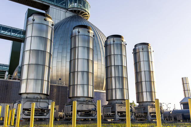
One leaned into it, and began quickly scuttling eastwards, past the largest source of greenhouse gas in the borough of Brooklyn, pictured above and found at the Department of Environmental Protection property known as “the sewer plant in Brooklyn.” Those four pipes are burning off the methane produced by the sewer plant. The venturi jet burner is tuned up to produce a clear flame, and you need to look for the heat distortion emanating from the things to visualize the horror of it all.
DEP has been working with the National Grid outfit for nearly a decade to work out a “waste to energy” program which would harvest the greenhouse gas, and will often talk about this project in public in a manner suggesting that it’s up and running, but in reality not a single visible screw has been turned yet and it’s kind of a scandal waiting to explode and embarrass them.
– photo by Mitch Waxman
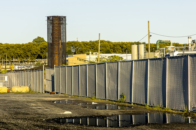
Every time might be the last time…
You may have noticed that I’m centering that scaffold clad chimney in a few of my shots lately. It’s all that remains of Van Iderstine, the ghastly fat rendering company who’s redolent presence defined the Queens side of the Greenpoint Avenue for nearly a hundred years. It’s being taken down and demolished currently, which feels like a quite appropriate thing for me to witness, as regarding my own situation. The edifices of the past and all that.
More next week, at this – your Newtown Pentacle.
“follow” me on Twitter- @newtownpentacle
Buy a book!
“In the Shadows at Newtown Creek,” an 88 page softcover 8.5×11 magazine format photo book by Mitch Waxman, is now on sale at blurb.com for $30.


