Posts Tagged ‘New York City’
whisper leeringly
Monday

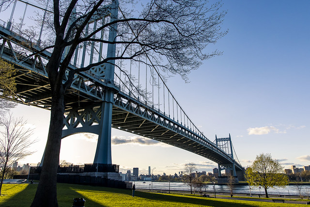
– photo by Mitch Waxman
On April 13th, I found myself at a rooftop bar on the east side of Manhattan, one which offered somewhat sweeping views of the East River. Queensboro Bridge was large and in charge, of course. In the lower right foreground, that’s “Four Freedoms Park” on Roosevelt Island. You’re looking in the general direction of Astoria, diagonally towards LaGuardia airport.
There you go, that’s what that looks like, and you didn’t have to pay $20 for an “old fashioned” to see it.
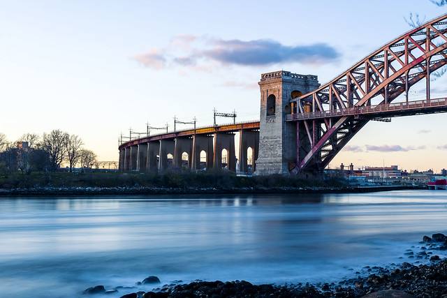
– photo by Mitch Waxman
On April 17th, a humble narrator felt like doing some shooting but didn’t want to return to Newtown Creek again, so Shore Blvd. alongside Astoria Park and the Hells Gate section of the East River was decided upon as a destination for the evening’s effort.
I’ve actually been trying to make it a point of being present during sunsets of late, as you may have noticed.

– photo by Mitch Waxman
Hell Gate Bridge is to the north, Mighty Triborough to the south. These waters are still pretty complicated from a maritime point of view – strong currents and eddies. The United States Army Corps of Engineers blew this part of the river up “back in the day” to cure up the navigation issues, but it’s still a part of the harbor that requires a bit of skill on the part of whomsoever is driving the boat.
– photo by Mitch Waxman
I set myself up for “landscape mode” with the tripod and an ND filter and started capturing a series of longish exposures. It was so bright out, in fact, that even with the filter on I was getting no more than ten seconds worth of exposure time.

– photo by Mitch Waxman
As I’ve mentioned several times, high flying clouds turn colorful during sunsets. No guarantee you’re going to get scarlets and crimsons, but when you do…

– photo by Mitch Waxman
I hung around until it got dark, then got scared by the presence of teenagers in Astoria Park so I rapid scuttled away from the area in a paroxysm of terror. One flew through the streets, his brain awash in the steroids of panic. Teenagers… brrr… no impulse control.
At HQ, I barred the doors behind me, and commanded Our Lady of the Pentacle to descend into the storm bunker with me and hunker down in case the adolescents had followed me home.
“follow” me on Twitter- @newtownpentacle
Buy a book!
“In the Shadows at Newtown Creek,” an 88 page softcover 8.5×11 magazine format photo book by Mitch Waxman, is now on sale at blurb.com for $30.
smiling dromedary
Friday

– photo by Mitch Waxman
My long walk around a short creek continued, and the Newtown Creek Nature walk allowed me an easy path through Brooklyn’s Greenpoint section. Pictured above is one of the lesser known tributaries of Newtown Creek – Whale Creek – and that’s a NYC DEP “Sludge Boat” docked along it.
Sludge Boats transport the processed/treatment sewer solids from the 12 sewer plants to the 13th one on Randall’s/Wards Island where it’s dewatered in centrifuges.

– photo by Mitch Waxman
Kingsland Avenue hugs the fences of the sewer plants, and it’s also where Newtown Creek Alliance HQ is found (520 Kingsland).
It’s a pretty crappy experience on foot, have to say.

– photo by Mitch Waxman
Those cylinders are exhaust pipes for the sewer plant, which burn off the methane produced by the treatment process, directly into the atmosphere. That makes the Department of Environmental Protection the single largest and most constant source of greenhouse gases in the entire Borough of Brooklyn.
Remember that when Eric Adams mandates that you need to spend $100,000 to convert your house over to electric from whatever you use to heat and cook in it right now.

– photo by Mitch Waxman
Kingsland Avenue carried my carcass to Greenpoint Avenue and it’s eponymous bridge. This shot is looking east along Newtown Creek. Brooklyn is on the right, Queens on the left.

– photo by Mitch Waxman
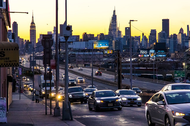
Things were getting pretty surreal, sky wise. Everything was painted in saturated radiates as the burning thermonuclear eye of God itself descended into whatever the hell might be on the other side of New Jersey.
– photo by Mitch Waxman
My very productive day wasn’t over yet, I’d mention.
Cannot tell you how many times this exact same route has disappointed. Part of the reason I walk it so often are days like the 12th of April.
Back next week with more wonders, at this – your Newtown Pentacle.
“follow” me on Twitter- @newtownpentacle
Buy a book!
“In the Shadows at Newtown Creek,” an 88 page softcover 8.5×11 magazine format photo book by Mitch Waxman, is now on sale at blurb.com for $30.
peradventure may
Thursday

– photo by Mitch Waxman
The estimable bridge tenders of the NYC DOT were on station at the Pulaski Bridge when a humble narrator scuttled by. What makes them “estimable” is that if you see them hanging around a draw bridge, odds are that the bridge will be opening soon, hence you can estimate.
These are more photos from an extremely productive walk I took on the 12th of April. Six photo posts have been offered here for awhile now, as I’m trying to “catch up” with the real world calendar.

– photo by Mitch Waxman
Pulaski Bridge is the first crossing of Newtown Creek you encounter when navigating in from the East River. Constructed in 1954 at the behest of Robert Moses’s DOT, Pulaski Bridge carries five lanes of auto traffic as well as dedicated pedestrian and bike lanes. It’s a double bascule draw bridge, electrically powered, and is part of the NYC DOT’s portfolio of movable bridges. It connects Greenpoint’s McGuinness Blvd. with LIC’s 11th street.
One thereby scuttled across “the red one” to Paidge Avenue in Brooklyn, which allowed me to enter the Newtown Creek Nature Walk.

– photo by Mitch Waxman
The sewer plant in Greenpoint was reconstructed beginning in the early 1990’s, and the NYC DEP was compelled to comply with the NYC Charter requirement of “1% for art,” which sets aside a percentile of every municipal construction project for art or public space. The Nature Walk, thereby, wraps around the sewer plant and is accessible via either Kingsland Avenue or Paidge Avenue between dawn and dusk. It’s proven to be quite a popular destination for Greenpointers.
As I arrived, I spotted two tugboats at work.

– photo by Mitch Waxman
Sea Lion, pictured above, was towing a recycling barge from the SimsMetal dock found on the Queens side of Newtown Creek. Sims does a lot of maritime shipping from this dock. They handle recyclables collected by DSNY, crushed cars, and all sorts of scrap metal here. The materials are brought in by truck, but shipped out by barge. A maritime barge carries the equivalent cargo of 38 heavy trucks.
Sea Lion is a harbor tug, as in its fairly small in size at 64.7 feet in length, but the 1980 vintage vessel is mighty – she produces 1,400 HP, which is more than that railroad engine I showed you the other day. Ocean going tugs are fairly enormous.

– photo by Mitch Waxman
A larger class tug, the Seeley, was waiting patiently for the bridge tenders to open up Pulaski Bridge. Sea Lion didn’t need the bridge to open, as the height of her conning tower and antennae were well below the bridge’s double bascule undersides.
The horns began to blow, and then the chiming of the signal arms sounded, and then traffic stopped flowing over the Pulaski Bridge for an interval so that a different type of traffic could pass.

– photo by Mitch Waxman
Seeley navigated through, and although I’m incapable of the emotional state called “happy,” a humble narrator was slightly less miserable than normal for a few minutes.
More tomorrow.
“follow” me on Twitter- @newtownpentacle
Buy a book!
“In the Shadows at Newtown Creek,” an 88 page softcover 8.5×11 magazine format photo book by Mitch Waxman, is now on sale at blurb.com for $30.
lute dancer
Wednesday

– photo by Mitch Waxman
The tunnels leading into Manhattan that are used by the Long Island Railroad are found within the Sunnyside Yards. On the south shore of Queens along Newtown Creek, however, you’ll find the LIRR’s Lower Montauk tracks which lead east. Used to be that the Lower Montauk could connect to the Yards via the Montauk Cutoff, but those tracks are now “abandoned,” and my friends and I have been working for a few years now to turn the cutoff into an “official” public open space – so no bueno for connecting anymore. The Montauk Cutoff is de facto “unofficial” public open space right now, but that’s another story.
Lower Montauk line starts at the LIRR’s Hunters Point Yard in Long Island City, found along Borden Avenue, which has been an active rail yard since the 1860’s.

– photo by Mitch Waxman
A siding leaves the Lower Montauk and crosses Borden Avenue at street grade, after traveling under the Pulaski Bridge. This siding first enters the Hunters Point Avenue LIRR station about two blocks from the spot pictured above, and those tracks then offer connection to the Main Line and the tracks heading to Woodside, and Jamaica. These latter connections are beyond that which I can speak intelligently about, so if you think you know more about this than I do – you’re right, you do.
LIC, though, that’s my jam.

– photo by Mitch Waxman
The Lower Montauk tracks almost always have a couple of idling engines sitting on them, which I’m told are kept ready to roll in case of an emergency or if a non functioning train on the busier parts of the system needs a rescue. They also tow work trains and “maintenance of way” equipment about.
That’s LIRR engine 105 pictured above, which was built sometime between 1968 and 1981. It’s a 1,000 HP locomotive engine.

– photo by Mitch Waxman
Engine 164 is pictured above, which I can’t tell you much about. It’s gloriously rusty, and can really use a paint job – that’s all I’ve got.
The tracks they’re sitting on are on the Lower Montauk line. Eastwards, these engines can connect first to the Wheelspur Yard, or travel over the DB Cabin bridge spanning Newtown Creek’s Dutch Kills tributary leading into the Blissville Yard, on their way eastwards to the interlocking at Haberman or all the way to the Fresh Pond yard. Along the way, in Ridgewood, the LIRR Bushwick Branch intersects and connects.

– photo by Mitch Waxman
MTA stores their “rolling stock” in between rush hours at the Hunters Point Yard, and twice a day there’s an absolutely terrific amount of activity down here in DUPBO, Down under the Pulaski Bridge Onramp.
This is one of the most infrastructure heavy areas I know. The draw bridge above, rail and vehicles traffic on the surface, and the Long Island Expressway is feeding traffic into the Queens Midtown Tunnel below.
In my experience, between 4 & 6 in the afternoons, you’re almost guaranteed to see something LIRR related happening here.

– photo by Mitch Waxman
Saying all that, my very productive day wasn’t over by a long shot, and I decided to crack out a “long shot” while climbing the Pulaski’s stairs and heading over towards Brooklyn’s Greenpoint section.
Wonders, I tell you, wonders.
“follow” me on Twitter- @newtownpentacle
Buy a book!
“In the Shadows at Newtown Creek,” an 88 page softcover 8.5×11 magazine format photo book by Mitch Waxman, is now on sale at blurb.com for $30.
budding branches
Tuesday

– photo by Mitch Waxman
April 12th offered an extremely productive evening up to me. The weather was perfect – crisp and clear – and I had no obligations to hold me back from just wandering around the “study area.” A long walk was on the menu, so here we go…
First stop was at “hole reliable” along the fence lines of the Sunnyside Yards, where a Long Island Railroad train was hurtling through the Harold Interlocking on its way into Manhattan.

– photo by Mitch Waxman
Next up was yet another visit to Long Island City’s 29th street to document the continuing collapse of a bulkhead into Newtown Creek’s Dutch Kills tributary.
Fill in the blanks: XXXXXXX matters, XXXXXX cares.

– photo by Mitch Waxman
Yup, getting worse, every time it rains.
Can’t wait to call out the elected officials and agency personnel at the funeral of whomsoever ends up dying here when the street collapses. I will happily testify at the court case too.

– photo by Mitch Waxman
One continued on his merry way, and decided that tonight would a good one to loop across the Newtown Creek at the Pulaski Bridge and then use the Newtown Creek Nature Walk to connect to the Greenpoint Avenue Bridge via Kingsland Avenue to get back to Queens.
As it turned out, this was a fortuitous idea, as you’ll see later on this week.

– photo by Mitch Waxman
Checked in on my beloved tree of Paradise, which was just beginning to bud with spring time foliage.
I continued up to Borden Avenue.

– photo by Mitch Waxman
Long Island Railroad 404 was crossing Borden Avenue, on its way to the Main Line tracks at Sunnyside Yards. There’s a bit of complicated rail infrastructure nearby.
I’ll attempt to talk about that in some detail tomorrow, at this – your Newtown Pentacle.
“follow” me on Twitter- @newtownpentacle
Buy a book!
“In the Shadows at Newtown Creek,” an 88 page softcover 8.5×11 magazine format photo book by Mitch Waxman, is now on sale at blurb.com for $30.


