Posts Tagged ‘newtown creek’
enchanting metamorphoses

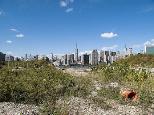
– photo by Mitch Waxman
Recent announcements have heralded the formal beginnings of the process which will transmogrify the ancient Hunters Point section of Long Island City irrevocably. The support of overt interests of the Manhattan political elite have been made in public, and the financial and real estate folks are in line behind the project.
Behold, the future home of an estimated 11,000 people, imagine Tower Town.
from nyc.gov
More than 5,000 new apartments are anticipated to be constructed in the primary neighborhood character study area by 2017, including completion of the residential development at Queens West and many other mid-size residential buildings throughout the immediate area. Almost 11,000 new residents are expected in the primary study area as a result of this new construction activity.
As the primary study area (and the secondary study area, discussed below) becomes more densely developed, traffic and pedestrian volumes will increase noticeably from the current levels. Intersections throughout the area will be more congested in the morning, midday, and evening peak hours. The intersections that currently experience some congestion on Vernon Boulevard will be noticeably more congested, with some levels of service D and even LOS F, indicating high to unacceptable delays. In addition, other intersections along Vernon Boulevard in the primary study area will also have moderate to high congestion in the peak hours. On the east-west avenues in the area near the project sites (i.e., 48th, 49th, 50th, and 51st Avenues) traffic volumes are expected to increase slightly.
Pedestrian volumes will also increase in the future without the proposed actions, but sidewalks, corners, and crosswalks will generally continue to operate at acceptable levels. The crosswalk across Vernon Boulevard on the north side of 50th Avenue will, however, become noticeably congested during the morning peak hour, as people cross to enter the subway station there. This crosswalk will operate at LOS E, as will the subway stair closest to the corner (Stair S8). Buses serving the primary study area will also be noticeably more crowded.

– photo by Mitch Waxman
Direct sightlines of the heroic Manhattan skyline will be offered by these new high rise buildings, and soar over the starry old coastline that has known only industrial usage since the first Europeans arrived on the archipelago we know as New York. Its value for industry has long been exhausted, and today it is a brutal waste of land.
also from nyc.gov
The proposed actions would almost double the study area’s population. However, the proposed actions’ mix of affordable and market-rate housing could serve to relieve rather than increase residential market pressure in the study area. Additionally, given the very strong trend already in place in the neighborhood, the new population at Sites A and B would not be expected to introduce or accelerate a trend toward increased market rents in the study area that might cause significant indirect residential displacement. The redevelopment of Site B would introduce new residential uses to the Long Island City industrial area south of Borden Avenue. It is possible that the introduction of this residential use could lead to some limited indirect business displacement because of increased rent pressures. However, the potential for indirect displacement resulting from increased rent pressure is limited, and would not result in significant adverse indirect displacement impacts.

– photo by Mitch Waxman
The new development, a planned community with parks and schools, will extend far from the river- nearly all the way to the Pulaski Bridge with a basketball court and green space sited for the location of the old Vernon Avenue Bridge. The shining city of Queens, and a monument to a revolutionary and aggressive group of city planners, the story of Tower Town has begun.
also from nyc.gov
The Hunter’s Point South Rezoning and Related Actions would allow Site A and Site B to be redeveloped with largely residential buildings with building components ranging in height from
40 to 400 feet. Ground floors would include local retail, lobby, and community facility uses. On Site A, a network of new streets, sidewalks, and bikeways would be developed, creating seven new city blocks from the single 30-acre parcel it is today. Center Boulevard would be continued southward onto Site A and would connect to the rest of the street network. On Site B, it is anticipated that a new publicly accessible private road and open space would roughly bisect the site. The new residential buildings would vary in height, with bases ranging in height from 40 to 70 feet and high rise elements ranging in height from 250 to 400 feet. Nine towers would be developed on Site A, and four towers would be developed on Site B. Ground floors would be occupied by local retail and other commercial uses and community facility uses. A new public school would serve the residents of the buildings and the surrounding neighborhood and create a varied and active streetscape.
In addition, a new public waterfront park would be developed along the East River and Newtown Creek frontages of Site A and a shore public walkway would be developed along the Newtown Creek frontage of Site B. An additional linear public park would also be developed on the south side of 55th Avenue between Center Boulevard and 2nd Street, and a similar public open space would be developed on the south side of the publicly accessible private road on Parcel B, creating a wide boulevard on that street. The new waterfront parks and open spaces on Sites A and B along the East River and Newtown Creek waterfronts would provide greatly increased public access to waterfront views. Wide views of the waterfront and Manhattan would be available from locations throughout the park.
Overall, the proposed actions would change the character of Sites A and B from a commercial and industrial neighborhood to a residential neighborhood. This new residential neighborhood would incorporate retail and park uses that would attract visitors. On both Site A and Site B, pedestrian activity and vehicular activity would increase substantially over existing conditions.
– photo by Mitch Waxman
Tower Town is impossible to argue against, this real estate- former home to rail and ferry docks, and 19th century barge based casinos, and printing plants, and refineries, and power plants- is a blight on the city, and an uncomfortable reminder of that earlier time when brick strewn lots were not remarkable but common.
An economic boom in construction and real estate sales will come, when it is built. A new tax base of luxury and glamour will come to western Queens, and a wildfire of enhanced valuation will spur growth throughout surrounding riverine communities- further enhancing the economy and strengthening their own tax base- Dutch Kills first, then Astoria, and Greenpoint.
Tower Town at Hunters Point South, Atlantic Yards in Brooklyn, Flushing Commons, Willets Point, the Kosciuszko Bridge replacement.
All at once.
from “Air Quality In Queens County” at synapse-energy.com
In the interest of protecting the environment and public health of Northwest Queens, the Natural Resource Defense Council (NRDC) and the Citizens Helping Organize for a Klean Environment (CHOKE) participated in the New York State Article X permitting process for several new power plants proposed in Northwest Queens. One of their objectives was to have a study conducted to analyze the contributors to air pollution in Northwest Queens and to identify possible strategies for improving air quality and reducing risks to public health. As part of the Article X permitting process for its 250 MW Ravenswood Combined Cycle project, KeySpan committed to funding such a study as a community benefit. CHOKE and NRDC contracted with Synapse to conduct this study. The conclusions and recommendations are those of the authors but do not necessarily reflect the position of KeySpan.
One of the reasons that Queens County was chosen for this study is that it is home to many sources of air pollution. In the northwest corner of the county there currently are four large power plants, which together house 46 electric generating units. The county also contains an extensive transportation network that includes the Long Island Expressway, the Brooklyn Queens Expressway, the Grand Central Parkway, two highway bridges, a tunnel to Manhattan, and two airports, along with over 400 miles of arterial and local roads. Queens also has several large industries, and some 2.2 million residents, leading to significant economic activity which contributes to air quality problems.

– photo by Mitch Waxman
A small and insignificant scuttling thing who some might describe as a man, your humble narrator has spent a good deal of time wandering about the lonely industrial frontages of Hunters Point and expended some effort into learning its past. My opinion of this project is meaningless, it is a gathering thunderhead, and Manhattan is coming to Queens. There is just one thing that has been glossed over in mainstream reports about this place…
…this waterfront property…
from a Newtown Pentacle post of 6/7/2009
In 1697, a Dutch sea captain named Peter Praa bought the Bogardus properties and set up farming. He died in 1740, and the land was left to his granddaughter Anne Bennet. Her son, Jacob Diks, inherited next and he passed the land to his daughter- Anna Hunter. In 1817, Hunter, who had three sons, left the land to her children under the proviso that it be sold and the moneys divided evenly between them. This is why the “Mispat” became known as “Hunter’s Point”.

– photo by Mitch Waxman
For the water that promoters of this plan mention is the East River, not the water that has defined it throughout all recorded time.
from a Newtown Pentacle post of 2/28/10:
3.8 miles long, its mouth is directly opposite the Bellevue Psychiatric Hospital in Manhattan, and defines the currently undefended border between North Brooklyn and Western Queens. Estimates state that some 14 million gallons of combined sewage, storm runoff, and industrial waste provide the only flow of water into the Creek. It’s waters are opaque, and in the height of summer turn an unnatural shade of green.
The soft bottom of the waterway is 15-20 feet below the surface of the water, and the hard bottom is occluded by a gelatinous sediment known as “Black Mayonnaise”. Composed of petroleum residues, coal tar, PCB’s, and human excrement- it lies 15 feet thick on the bed. The oxygen content of the water drops precipitously as soon as one leaves the East River. The first of the drawbridges which cross it- known as the Pulaski Bridge, is the borderline beyond which immersion in this water is worthy of full HAZMAT gear and first responders institute biological decontamination procedures for anyone who finds themselves in it.
As I’ve mentioned in the past… the chemicals Putrescine (an organic chemical compound NH2(CH2)4NH2 (1,4-diaminobutane or butanediamine) and Cadaverine (a toxic diamine with the formula NH2(CH2)5NH2)which are produced by the rotting and putrefaction of animal flesh are abundantly found in the Newtown Creek under industrial aliases like Acrylonitrile and are prominent members on the EPA’s list of Volatile Organic Compounds– or VOC’s..
Who can guess, what it is, that may be buried down there?

– photo by Mitch Waxman
Tower Town, you see, will be built along the Creek as well…
…the Newtown Creek…
from epa.gov
“Newtown Creek is one of the most grossly-contaminated waterways in the country,” said Acting Regional Administrator George Pavlou. “By listing the creek, EPA can focus on doing the extensive sampling needed to figure out the best way to address the contamination and see the work through.”
EPA responded to requests by members of Congress to evaluate specific sites along the creek by publishing a September 2007 report that contained a review of past work and recommendations regarding future work at Newtown Creek. The state of New York referred the site to EPA due to the complex nature of the contamination along the creek.
Newtown Creek is part of the core area of the New York-New Jersey Harbor Estuary, which has been designated by EPA as an “estuary of national significance.” Despite the ongoing pollution problems, some residents currently use the creek for recreational purposes such as kayaking, while others catch fish for consumption out of it. Various sediment and surface water samples have been taken along the creek and reveal the presence of pesticides, metals, PCBs, and volatile organic compounds (VOCs), which are potentially harmful contaminants that can easily evaporate into the air.
In the mid -1800s, the area adjacent to the 3.8-mile Newtown Creek was one of the busiest hubs of industrial activity in New York City. More than 50 industrial facilities were located along its banks, including oil refineries, petrochemical plants, fertilizer and glue factories, sawmills, and lumber and coal yards. The creek was crowded with commercial vessels, including large boats bringing in raw materials and fuel and taking out oil, chemicals and metals. In addition to the industrial pollution that resulted from all of this activity, the city began dumping raw sewage directly into the water in 1856. During World War II, the creek was one of the busiest ports in the nation. Some factories and facilities still operate along it, and various adjacent contaminated sites have contributed to its contamination. Today, as a result of its industrial history, including countless spills, Newtown Creek is badly polluted.
MV Red Hook at Brooklyn Bridge

– photo by Mitch Waxman
Our Lady of the Pentacle suffers much for my obsessions with the municipal sewage infrastructure of the City of Greater New York. Endless hours of monotone exposition greets her whenever a significant appliance or facility is encountered, and today you- lords and ladies- will share her pain. That’s the M/V Red Hook sludge boat soldiering down the East River, and passing beneath the Brooklyn Bridge.
from wikipedia
Contemporaries marveled at what technology was capable of and the bridge became a symbol of the optimism of the time. John Perry Barlow wrote in the late 20th century of the “literal and genuinely religious leap of faith” embodied in the Brooklyn Bridge … “the Brooklyn Bridge required of its builders faith in their ability to control technology.”
References to “selling the Brooklyn Bridge” abound in American culture, sometimes as examples of rural gullibility but more often in connection with an idea that strains credulity. For example, “If you believe that, I’ve got a bridge to sell you.” References are often nowadays more oblique, such as “I could sell you some lovely riverside property in Brooklyn …”. George C. Parker and William McCloundy are two early 20th-century con-men who had (allegedly) successfully perpetrated this scam on unwitting tourists. The 1949 Bugs Bunny cartoon Bowery Bugs is a joking reference to Bugs “selling” a story of the Brooklyn Bridge to a naive tourist.

– photo by Mitch Waxman
Speculative destinations for the Red Hook could include storied Greenpoint, where the product of the Temple of Cloacina might require transport, or the Wards Island facility where the syrupy product of New York’s human infestation will be dewatered and processed into cakes of concentrated nightsoil.
Sludge treatment
The following are typical stages of the sludge treatment process.
Thickening
The sludge produced by primary and secondary treatment is approximately 99% water and must be concentrated to enable its further processing. Thickening tanks allow the sludge to collect, settle and separate from the water for up to 24 hours. The water is then sent back to the head of the plant or to the aeration tanks for additional treatment.
Digestion
After thickening, the sludge is further treated to make it safer for the environment. The sludge is placed in oxygenfree tanks, called digesters, and heated to at least 95 degrees Fahrenheit for between 15 to 20 days. This stimulates the growth of anaerobic bacteria, which consume organic material in the sludge. Unlike the bacteria in the aeration tanks, these bacteria thrive in an oxygen-free or “anaerobic” environment. The digestion process stabilizes the thickened sludge by converting much of the material into water, carbon dioxide and methane gas. The black sludge that remains after digestion has the consistency of pea soup and has little odor. This is called digested sludge.
Methane gas is often used as an energy source at the City’s wastewater treatment plants. The gas may be used in engines to produce electricity or directly drive plant equipment. Gas is also used in boilers to provide heat for digestion and plant-wide buildings. Currently, DEP and the New York Power Authority (NYPA) have jointly installed fuel cells at four of the City’s water pollution control plants; 26th Ward, Red Hook, Oakwood Beach and Hunts Point. Fuel cells convert the methane gas and carbon dioxide into heat and electricity that is then used to operate the plants. This technology contributes to New York City’s efforts to enhance clean air operations at its facilities. There is a significant reduction in air emissions as a result of using fuel cells.
Digester sludge is pumped from sludge storage tanks to a dewatering facility. At some treatment plants, where there are no dewatering facilities on site, the sludge is transported for processing through a pipeline or by a sludge boat to a plant that has a dewatering facility.
opiate peace

– photo by Mitch Waxman
This is not a dead place, this Creek which forms the currently undefended border between much of Brooklyn and Queens, despite wholly inaccurate statements to the contrary recently presented by major publications. To begin with, there is the teeming human infestation, whose population is in the millions. Additionally- migratory birds, invertebrate and vertebrate water fauna, and an enormous hidden population of higher mammals lurk amongst the canalized shorelines of the Newtown Creek.
from the nytimes.com– an article that gets a lot of things completely wrong, which is surprising for the times, and seems to be shilling against “Big Oil”
People don’t often think of urban creeks as biodiverse waterways, but Newtown Creek was once a rich tidal estuary popular among hunters and fishermen. Starting in the 1870s, however, Standard Oil and other refineries began spilling or dumping excess fuels and toxic chemicals into the water or onto the soil, slowly poisoning the ecosystem.

– photo by Mitch Waxman
Famously and recently, a Dolphin’s appearance near the Pulaski Bridge excited the neighboring communities, but such extravagances of nature would have a difficult time at Newtown Creek. There are ocean going and brackish water fish that get swept into the Creek by the East River’s irresistible tidal cycles, which actually drown in the oxygen poor water, but I’ve observed other things swimming in its shallow depths. Weird squamous things that defy description, burrowers and soft bodied tunnelers which thrive in the putrid muds that line its soft bottom. Perhaps, when the federal EPA superfund work begins, studies of these uncommented organisms will commence.
Hey, not everything that lives is beautiful, but against all the odds- life is tenacious and nature will find a way to get by.
from epa.gov
Newtown Creek is a part of the New York – New Jersey Harbor Estuary that forms the northernmost border between the New York City boroughs of Brooklyn and Queens. In the mid 1800s, the area adjacent to the 3.8 mile Newtown Creek was one of the busiest hubs of industrial activity in New York City. More than 50 refineries were located along its banks, including oil refineries, petrochemical plants, fertilizer and glue factories, sawmills, and lumber and coal yards. The creek was crowded with commercial vessels, including large boats bringing in raw materials and fuel and taking out oil, chemicals and metals. In addition to the industrial pollution that resulted from all of this activity, the city began dumping raw sewage directly into the water in 1856. During World War II, the creek was one of the busiest ports in the nation. Currently, factories and facilities still operate along the creek. Various contaminated sites along the creek have contributed to the contamination at Newtown Creek. Today, as a result of its industrial history, including countless spills, Newtown Creek is one of the nation’s most polluted waterways.
Various sediment and surface water samples have been taken along the creek. Pesticides, metals, PCBs, and volatile organic compounds (VOCs), which are potentially harmful contaminants that can easily evaporate into the air, have been detected at the creek.
In the early 1990s, New York State declared that Newtown Creek was not meeting water quality standards under the Clean Water Act. Since then, a number of government sponsored cleanups of the creek have taken place. The New York City Department of Environmental Protection has sampled sediment and surface water at a number of locations along the creek since 1980. In 2009, EPA will further sample the sediment throughout the length of Newtown Creek and its tributaries. The samples will be analyzed for a wide range of industrial contaminants. EPA will use the data collected to define the nature of the environmental problems associated with Newtown Creek as a whole.
Circumnavigation 4

– photo by Mitch Waxman
After sliding past the Williamsburg Bridge, the Circle Line narrator began to talk about Queensboro (he called it 59th street bridge- grrrr) and didn’t mention the Newtown Creek. Tourists wouldn’t want to hear about that story, I guess. One thing that really annoyed your humble narrator were the constant references to pop culture icons like the Seinfeld sitcom and the Spiderman movies. Realization that that’s what tourists have as touchstones for NYC is obviated, but still… blurring the line between fantasy and reality is a real issue in the modern world.
from wikipedia
George Louis Costanza is a fictional character in the American television sitcom Seinfeld (1989–1998), played by Jason Alexander. He has variously been described as a “short, stocky, slow-witted, bald man” (by Elaine Benes and Costanza himself), “Lord of the Idiots” (by Costanza himself), and as “the greatest sitcom character of all time”. He is friends with Jerry Seinfeld, Cosmo Kramer, and Elaine Benes. George appears in every episode except for “The Pen” (third season). The character was originally loosely based on Seinfeld co-creator Larry David, but surnamed after Jerry Seinfeld’s real-life New York friend, Mike Costanza.

– photo by Mitch Waxman
The power of cinema and television to present a cogent and absorbing telling of historical events is actually a dangerous thing. Again, I realize that the tourists aboard the Circle Line aren’t looking for hardcore history, but there’s a lot to say about the Queensboro bridge that doesn’t involve the Green Goblin or George Costanza. History is made not by accurate or cogent catalogs of events, but by distribution. The reason we know about Aristotle or Voltaire is that MANY copies of their work were made, distributed across a wide area, and were quoted by others. This means that distaff copies of their work survived the fires and floods. This means that to future eyes, the surviving copies of Spiderman and Goodfellas might be all they have.
Which makes me wonder if Pliny the Younger might have been the Dean Koontz of his time.
from wikipedia
As they watch over May in the hospital, Mary Jane tells Peter she has a crush on Spider-Man, and Peter expresses his own feelings for her. Harry catches them holding hands and tells his father about their love for each other. Now knowing that Spider-Man has feelings for Mary Jane, the Goblin lures him to the top of the Queensboro Bridge by taking Mary Jane and a Roosevelt Island Tramway car full of children hostage, then drops both at the same time. Spider-Man saves them all, but the Goblin takes him to an abandoned building for a fight. Spider-man eventually defeats and unmasks the Goblin, and Norman dies after asking Peter not to tell Harry that he (Norman) was the Goblin.

– photo by Mitch Waxman
As the boat passed Roosevelt Island, the looming hotel construction sites of Queens Plaza rise behind it. Within a few years, tens of thousands of Queens Plaza and Dutch Kills hotel rooms will be serving the self same tourist trade which is satisfied by attractions like these Circle Line cruises. Perhaps this is what we New Yorkers are destined to become, apes in a steel and glass cage put on display for foreigners as we live out our funny lives. Just like on Seinfeld.
from wikipedia
Tourism in New York City includes nearly 47 million foreign and American tourists each year. Major destinations include the Empire State Building, Ellis Island, Broadway theatre productions, museums such as the Metropolitan Museum of Art, and other tourist attractions including Central Park, Washington Square Park, Rockefeller Center, Times Square, the Bronx Zoo, South Street Seaport, New York Botanical Garden, luxury shopping along Fifth and Madison Avenues, and events such as the Tribeca Film Festival, and free performances in Central Park at Summerstage and Delacorte Theater. The Statue of Liberty is a major tourist attraction and one of the most recognizable icons of the United States. Many New York City ethnic enclaves, such as Jackson Heights, Flushing, and Brighton Beach are major shopping destinations for first and second generation Americans up and down the East Coast.

– photo by Mitch Waxman
Of course, the folks whose lives are a little too funny can be found on Ward’s Island at the psychiatric hospitals that serve the City of Greater New York. I’m never quite sure which building is which in this complex, as your humble narrator is convinced that getting too close to a madhouse would be injurious to his freedoms, but this is either the 509 bed Manhattan Psychiatric Center (I lean toward this) or the maximum security Kirby Forensic Psychiatric Center. The Circle Line narration didn’t mention either.
from soundportraits.org
There seem to be two constants to life on Ward 2-West. One of these is violence. The state considers the staffers who work on the ward to hold the single most dangerous job in New York, with the highest injury rate of any profession. The other constant on the ward is noise. There is nowhere to escape it, although there is one patient who seems to have adapted to it quite well. His name is Peter, and you can always find him at the front of the dayroom, hunched over a table peacefully drawing with yellow plugs stuffed deep into his ears. He is about 50 years old, has curly brown hair and a graying beard, gentle eyes behind thick glasses. Before committing his crime, Peter was a successful commercial artist. Today he’s working on a still life with pastels.

– photo by Mitch Waxman
Amongst the more pleasant realities of the trip was this view of the Hell’s Gate with its two spans- the Triborough Bridge(s) and the Hellgate railroad Bridge. The plane taking off from nearby LaGuardia airport was pure serendipity.
from wikipedia
Hell Gate is a narrow tidal strait in the East River in New York City in the United States. It separates Astoria, Queens from Randall’s Island/Ward’s Island (formerly two separate islands that are now joined by landfill).
It was spanned in 1917 by the New York Connecting Railroad Bridge (now called the Hell Gate Bridge), which connects the Ward’s Island and Queens. The bridge provides a direct rail link between New England and New York City. In 1936 it was spanned by the Triborough Bridge (now called the Robert F. Kennedy Bridge), allowing vehicular traffic to pass between Manhattan, the Bronx, and Queens.

– photo by Mitch Waxman
The Hellgate Bridge has long graded approaches which sprawl out all the way to the Sunnyside Yards on one side and continental North America on the other, providing a freight and rail link between the archipelago of islands which form this City-State of ours. Triborough’s approaches and ramps are almost too numerous for me to count.
from wikipedia
The Robert F. Kennedy Bridge, better known as the Triborough or Triboro Bridge, is a complex of three separate bridges in New York City, United States. Spanning the Harlem River, the Bronx Kill, and the Hell Gate (part of the East River), the bridges connect the boroughs of Manhattan, Queens, and The Bronx via Randall’s Island and Ward’s Island, which are joined by landfill.
Often historically referred to as simply the Triboro, the spans were officially named after Robert F. Kennedy in 2008.

– photo by Mitch Waxman
As the boat motored past Ward’s Island, where the Canadian theatrical provocateur’s called Cirque du Soleil had set up a circus tent, the Amtrak Acela rumbled over the Hellgate tracks. The last part of this trip that I can claim intimacy with until we returned to the Hudson, the Circle Line continued Northward.
Venturing into the “not part of my beat” areas of the City of Greater New York which your humble narrator is least familiar with- specifically the northeast sections of Manhattan and La Bronx, I actually got see a few things I didn’t even suspect…
from wikipedia
Acela Express (often simply Acela) is Amtrak’s high-speed rail service along the Northeast Corridor (NEC) in the Northeast United States between Washington, D.C., and Boston via Baltimore, Philadelphia, and New York. It uses tilting technology which allows the train to travel at higher speeds on the sharply curved NEC without disturbing passengers, by lowering lateral centrifugal forces, based on the concept of banked turns.
Acela Express trains are the only true high-speed trainsets in the United States; the highest speed they attain is 150 mph (240 km/h), though they average less than half of that. Acela has become popular with business travelers and by some reckoning has captured over half of the market share of air or train travelers between Washington and New York. Between New York and Boston the Acela Express has up to a 37% share of the train and air market.
Searching for Gilman

– photo by Mitch Waxman
For several months I have been searching Calvary Cemetery in a non systematic manner for 2 particular locations. Thwarted time and again by false leads and incorrect addressing, both sites have remained elusive. One grave is the final resting place of Tess Gardella– the actress who portrayed Aunt Jemima- and the other is that of an enigma from the early 20th century whose name was Gilman.
from wikipedia
Aunt Jemima is a trademark for pancake flour, syrup, and other breakfast foods currently owned by the Quaker Oats Company. The trademark dates to 1893, although Aunt Jemima pancake mix debuted in 1889. The Quaker Oats Company first registered the Aunt Jemima trademark in April, 1937.
The name “Jemima” is biblical in origin. Jemima is the King James Version’s rendering of the feminine Hebrew name יְמִימָה (Yəmīmā), the first of Job’s daughters born to him at the end of his namesake book of the Bible.
The term “Aunt Jemima” is sometimes used colloquially as a female version of the derogatory label “Uncle Tom”. In this context, the slang term “Aunt Jemima” falls within the “Mammy archetype”, and refers to a friendly black woman who is perceived as obsequiously servile or acting in, or protective of, the interests of whites. The 1950s television show Beulah came under fire for depicting a “mammy”-like black maid and cook who was somewhat reminiscent of Aunt Jemima. Today, the terms “Beulah” and “Aunt Jemima” are regarded as more or less interchangeable as terms of disparagement in popular discourse.

– photo by Mitch Waxman
Somewhere in the viridian depths of Calvary Cemetery lies an unremarked merchant from Massachusetts, who died in an accident along the delirious Newtown Creek in 1931. No obituary I can find discusses him, and Gilman slid unnoticed into the hallowed loam of Calvary’s charitable sections. His anonymity came to an end when, according to neighborhood sources and contemporary diarists, a relict 3 masted schooner arrived at the Penny Bridge docks and ordered an eccentric monument be erected on Gilman’s resting place. The captain of that black ship, a leathery bastard named Marsh, collected Gilman’s belongings and sailed via Newtown Creek to the East River, turning North toward Hell Gate- ultimately disappearing into the mists of Long Island Sound heading for New England.
from noaa.gov
Click here for : Hell Gate and Its Approaches
This nautical chart depicts Hell Gate, a narrow channel on the East River, at the confluence of the Harlem River, which connects Long Island Sound with New York Harbor. The chart shows Hell Gate in 1851, which is the year that the U.S. Army began blasting ledges and rocks within Hell Gate to ensure safe passage through the channel.

– photo by Mitch Waxman
Rumors that this man was the same Gilman mentioned by members of the Boston Police Department in 1920, in connection with investigations into a string of sensational murders and for connections to a certain group of anarchists thought to be operating within the city. The Back Bay area of Boston, of course, is associated with the illustrious architect Arthur Delevan Gilman– but there doesn’t seem to be any involvement with Calvary’s mysterious Gilman other than a tangential coincidence of names.
from wikipedia
The Back Bay neighborhood was created when a parcel of land was created by filling the tidewater flats of the Charles River. This massive project was begun in 1857. The fill to reclaim the bay from the water was obtained from Needham, Massachusetts. The firm of Goss and Munson, railroad contractors, built 6 miles (9.7 km) of railroad from Needham, and their 35-car trains made 16 trips a day to the Back Bay. The filling of present-day Back Bay was completed by 1882; filling reached the existing mainland at Kenmore Square in 1890, and finished in the Fens in 1900. The project was the largest of a number of land reclamation projects, beginning in 1820, which, over the course of time, more than doubled the size of the original Boston peninsula. It is frequently observed that this would have been impossible under modern environmental laws.
Back Bay’s development was planned by architect Arthur Gilman with Gridley James Fox Bryant. Strict regulations produced a uniform and well-integrated architecture, consisting mostly of dignified three- and four-story residential (or once-residential) brownstones.

– photo by Mitch Waxman
Both saint and sinner alike can be found in the emerald devastations of First Calvary- governors, mayors, and priests share in the loam with common laborer and notorious gangster. There are multitudes here, vast tomb legions awaiting only the advent of their messiah to rise and walk the earth. Gilman is amongst the many, lost in the crowd. I will find him, and the notable monument raised in his honor- it is just a matter of time.
from wikipedia
While the Christian doctrine of resurrection conforms to Jewish belief, there is, however, a minority point of view, held by certain Jewish mystics and others,[who?] which asserts that those Jewish beliefs are in contradiction with the resurrection as taught by Isaiah (Isaiah 8:16 and 26:19) and Daniel (12:1 and 13) in which the resurrection was understood as being a doctrine of physical ‘Rebirth’.
Jesus appears to have been in general agreement with the position held by the Pharisees, as illustrated by his response to a question regarding marriage at the resurrection (Matthew 22:23-32, Mark 12:18-27 and Luke 20:27-40).
Most Christian churches continue to uphold the belief that there will be a general resurrection of the dead at “the end of time”, as described Paul when he said, “…he hath appointed a day, in the which he will judge the world…” (Acts 17:31 KJV) and “…there shall be a resurrection of the dead, both of the just and unjust.” (Acts 24:15 KJV).
Many of the early Church Fathers cited the Old Testament examples listed in the Judaism section above as either foreshadowing Jesus’s resurrection, or foreshadowing or prophesying a future resurrection of all the dead.

– photo by Mitch Waxman
Gilman, I have no first name or exact date of interment- which intensifies the difficulty in locating him- was supposedly a dealer in far eastern art. What his purpose was in coming to the Newtown Pentacle remains shadowed. Veiled references to the illegal importation of statuettes from the south Pacific, and distribution of these items to radical theosophists and heretic Masons in the Greenpoint and Maspeth neighborhoods can be gleaned from antiquarian sources but nothing definite enough for the consideration of the Lords and Ladies of Newtown has emerged. The statuettes it is said, are the product of the lost Saudeleur culture from Nan Madol found on fabled Pohnpei, and an item of particular interest to certain occultists.
from wikipedia
Nan Madol was the ceremonial and political seat of the Saudeleur dynasty, which united Pohnpei’s estimated 25,000 people. Set apart on the main island of Pohnpei, it was a scene of human activity as early as the first or second century AD. By the 8th or 9th century islet construction had started, but the distinctive megalithic architecture was probably not begun until perhaps the 12th or early 13th century.
Little can be verified about the megalithic construction. Pohnpeian tradition claims that the builders of the Lelu complex on Kosrae (likewise composed of huge stone buildings) migrated to Pohnpei, where they used their skills and experience to build the even more impressive Nan Madol complex. However, this is unlikely because radiocarbon dates have placed the construction of Nan Madol prior to that of Lelu. Like Lelu, one major purpose of constructing a separate city was to insulate the nobility from the common people.
A local story holds that when Nan Madol was being built a powerful magician living in the well inhabited region on the northwest of the island was solicited, and that his help was a major factor in completing the buildings. In particular, he was responsible for supplying the huge stone “logs” used in much of Nan Madol by “flying” them from their source to the construction site.
…Supposedly there was an escape tunnel beginning at the center of Nan Madol and boring down through the reef to exit into the ocean. Scuba divers continue to look for this “secret” route, but so far a complete tunnel has yet to be discovered.

– photo by Mitch Waxman
Gilman is meant to have been killed in a curious accident on the Queens bank of Newtown Creek in Blissville, when a bail of paper fell from a second story warehouse window along the negligent shoreline of the Newtown Creek. Crushed, the peculiar condition of his body was remarked on by several hardened Detectives used to such sights. Speculations that he had been previously deformed by Polio or some other childhood disease were made, but before our era of “antigenic vaccination as public policy” was enacted, monstrous alterations of the human form by disease organisms were a common sight. Disfigurements caused by Smallpox and Leprosy or the ravages of Tertiary Syphilis are seldom observed by we happy few that enjoy the luxury of western modernity.
from wikipedia
Tertiary syphilis usually occurs 1–10 years after the initial infection, however in some cases it can take up to 50 years. This stage is characterized by the formation of gummas, which are soft, tumor-like balls of inflammation known as granulomas. The granulomas are chronic and represent an inability of the immune system to completely clear the organism. They may appear almost anywhere in the body including in the skeleton. The gummas produce a chronic inflammatory state in the body with mass effects upon the local anatomy. Other characteristics of untreated tertiary syphilis include neuropathic joint disease, which is a degeneration of joint surfaces resulting from loss of sensation and fine position sense (proprioception). The more severe manifestations include neurosyphilis and cardiovascular syphilis. In a study of untreated syphilis, 10% of patients developed cardiovascular syphilis, 16% had gumma formation and 7% had neurosyphilis.
Neurological complications at this stage can be diverse. In some patients manifestations include generalized paresis of the insane, which results in personality changes, changes in emotional affect, hyperactive reflexes and Argyll-Robertson pupil. This is a diagnostic sign in which the small and irregular pupils constrict in response to focusing the eyes, but not to light. Tabes dorsalis, also known as locomotor ataxia, a disorder of the spinal cord, often results in a characteristic shuffling gait.

– photo by Mitch Waxman
Somewhere, amongst those who eternal lie, is Gilman. The disturbing detail that troubled the Detectives who investigated the reports of his death, the one that made for saloon conversation and idle speculation by neighborhood wags, was the fact that this deceased dealer in illicit eastern art had six fingers on both hands and that these polydactyl appendages were webbed all the way to the nail beds. Not much could be said about Gilman’s face, for the rodent population of Newtown Creek had discovered him long before the Police did.
Additionally, his shorter than normal legs also bore long healed scars that suggested some intense surgical experience- participation in the Civil War was speculated on by area Police, when Gilman would have been a young man. Amongst his few possessions was a watercolor postcard of some southern Plantation labeled as “Carfax Plantation, James River, Virginia”, which was quite out of place in the pockets of a Massachusetts trader who died alone during the middle of the night along Newtown Creek. Further speculations held out the possibility that Gilman hailed from a degenerate or illegitimate offshoot of the famed Gilman family of Exeter, New Hampshire.
Where and who is he? Where is Gilman?
from wikipedia
Winthrop Sargent Gilman (1808-1884) was head of the banking house of Gilman, Son & Co. in New York City. He was born in Marietta, Ohio to merchant Benjamin Ives Gilman and Hannah (Robbins) Gilman. Benjamin Ives Gilman, born in 1766, was a native of Exeter, New Hampshire, where his ancestors were among the most prominent early settlers and where he graduated in the first class of the Phillips Exeter Academy.
In 1837 Winthrop Sargent Gilman let the abolitionist Elijah Parish Lovejoy hide his printing press in one of Gilman’s warehouses in Alton, Illinois. In the ensuing riot the angry mob burned Gilman’s warehouse to the ground and killed Lovejoy. Following the Alton riots, Gilman moved to New York City and entered the family banking business.
He was married to Abia Swift Lippincott Gilman, who in 1900 narrowly escaped burning to death from a gasoline torch in front of the Charles Scribner mansion at 12 East Thirty-eighth Street.
Winthrop Gilman had an abiding interest in science and built a private observatory at his home ‘Fern Lodge’ at the Palisades, New York, where he frequently observed meteors.


