Posts Tagged ‘newtown creek’
strange and brooding apprehensions
CREEK WEEK continues… for the first installment, from the mouth at the East River to the Pulaski Bridge, click here. For more on just the Pulaski Bridge, click here.

– photo by Mitch Waxman (from the Queens Museum of Art’s “Panorama of the City of New York”)
Moving a quarter mile eastward along the Queens bulkheads of the Newtown Creek from the Pulaski Bridge, the first tributary encountered by the intrepid urban explorer and photographer is a canalized horror called the Dutch Kills.
This branch of the Newtown Creek watershed is about an hour’s walk from Newtown Pentacle HQ, and its locale is visited or transited rather regularly by your humble narrator, as I perform the penitential exertions ordered by my physicians as the curative for certain extant health issues. All ‘effed up, my version of such wholesome activity requires the presence of the macabre, and some element of existential danger. Luckily- the Newtown Creek offers, to those who seek it, succor and salvation for a variety of desires.
Detailed postings, in and around the immediate neighborhood of the Dutch Kills waterway, include:
- Dutch Kills, or let the Photos do the Walking
- Long Island City Zen 2 -The Empty Corridor
- Weird Synchronicity
- After the Fire
- affordable housing development on Borden Avenue
- cry fowl, and let slip…
from wikipedia
Dutch Kills is a sub-division of the larger neighborhood of Long Island City in the New York City borough of Queens. It was a hamlet, named for its navigable tributary of Newtown Creek, that occupied what today is centrally Queensboro Plaza. Dutch Kills was an important road hub during the American Revolutionary War, and the site of a British Army garrison from 1776 to 1783. The area supported farms during the 19th Century, and finally consolidated in 1870 with the villages of Astoria, Ravenswood, Hunters Point, Middletown, Sunnyside and Bowery Bay to form Long Island City.

– photo by Mitch Waxman
Leaving the main course of the Newtown Creek, just .8 of a mile beyond its mouth, the first thing one encounters is a somewhat worse for wear railroad swing bridge- called the Long Island Railroad Bridge. Reports from “railfans” and “foamers” (and confirmed by the Coast Guard) state that the bridge hasn’t opened since 2002, which has orphaned the Dutch Kills from its parent waterway and cut the canal off from its intended usage. If my readings of old maps are correct (they often aren’t), these two tracks carry (or at least carried) rail traffic from either the Montauk Cutoff and Montauk Branch tracks, connecting the LIRR to the Sunnyside Yard and Wheelspur Yard with the tracks leading west to Hellsgate and east to Long Island. Notable former sights along this bank of the Newtown Creek would have been the City of New York’s Poultry Yard and the still extant Texas Oil Co.
For an extensive series of historical photos, discussion of the function and design of these tracks, and the industrial centers they once served- trainsarefun.com is the place to go. Special attention is called to this 1860 map of the area– which details the natural flow of the wetlands and shows the Dutch Kills as being a far larger body of water than it is today.
from Queens Borough, New York City, 1910-1920
During 1914 bulkhead lines were established by the United States Government for Dutch Kills Creek, a tributary of Newtown Creek, thus putting this stream under the jurisdiction of the War Department. The bulkhead lines as approved on October 29, 1914, give a width varying from 200 feet at its junction with Newtown Creek to 150 feet at the head of the stream, and include a large basin in the Degnon Terminal where car floats can be docked. The widths of the channel to be dredged under the appropriation of $510,000 mentioned previously, range from 160 feet at Newtown Creek to 75 feet at the turning basin. The Long Island Railroad plans to establish at this point a large wholesale public market, estimated to cost nearly $5,000,000.
Among the larger industrial plants in the Degnon Terminal served by this stream are : Loose Wiles Biscuit Company, American Ever Ready Works, White Motor Company, Sawyer Biscuit Company, Defender Manufacturing Company, Pittsburg Plate Glass Company, Marcus Ward, Brett Lithograph Company, Waldes, Inc., Norma Company of America, Manhattan-Rome Company, American Chicle Co. and The Palmolive Co.

– photo by Mitch Waxman
From Borden avenue, the second rail bridge is observed, which I believe to be the Montauk Cutoff track and a bascule type drawbridge. The canalized Dutch Kills, with its high bulkheads and rail connections, served as a water connection to NY Harbor for several heavy manufacturers in the area including F.A. Hunt, Holdtronics, New York Envelope, and American Chicle. The rail/dock complex, collectively, was known as the Degnon terminal. A short but sweet history of the Degnon Terminal can be accessed at members.trainweb.com. Michael Degnon was a master builder, one of the great men of the early 20th century in Queens, and is buried in Calvary Cemetery. Check out this nytimes.com article which discusses an expansion of his operations at the Dutch Kills in 1922 that brought floor space at his Degnon Terminal up to an astounding three million square feet.
from forgotten-ny.com
Michael Degnon was the contractor for the Steinway Tunnel, the first rail link to connect Manhattan and Queens, and also the contractor for the Sunnyside Yards. He decided to build his own railway, called Degnon Terminal, adjacent to the Sunnyside Yards and constructed large factories and warehouses complete with sidings facing the railroad tracks. This was attractive to his clients, since shipping goods via rail was now more accessible and less expensive for them. Some of the Terminal’s early clients were Sunshine Biscuit Company, Packard Automobile Company, American Ever Ready Company, and American Chicle Company. Of course, the rising cost of doing business in New York forced all of these companies to find other cities in which to manufacture. The sidings haven’t seen rail traffic since 1989, and the tracks are now either paved over or overgrown with weeds (some of which can be seen on FNY’s Disappearing Railroad Blues page). In its heyday, Degnon Terminal employed 16,000 workers.

– photo by Mitch Waxman
The currently “under construction” Borden Avenue Bridge allows vehicle and pedestrian traffic to cross the Dutch Kills. This is the point at which the water quality declines seriously, as the only fresh water entering its stagnant depths are combined sewer outputs (CSO’s) and runoff from the concretized industrial landscape surrounding it (which carry a stream of road salt, engine and exhaust residue, and whatever else might be on the road or sidewalk into the water every time it rains). The bridge recently celebrated its centennial, incidentally.
from the army corps of engineers, discussing precautions for the collecting, handling, and testing of Dutch Kills underwater sediments:
All individuals involved in handling contaminated sediment are required to use protective equipment and to submit to blood and urine tests. The protective equipment consists of:
from nyc.gov
As part of the construction of Borden Avenue in 1868, a wooden bridge was built over Dutch Kills. This bridge was later replaced by an iron swing bridge, which was removed in 1906. The current bridge was opened on March 25, 1908 at a cost of $157,606. The deck’s original design consisted of creosote-treated wood blocks, with two trolley tracks in the roadway. Character-defining features of this bridge include the stucco-clad operator’s house, four pairs of rails, and a rock-faced stone retaining wall. The gable-on-hip roof of the operator’s house retains the original clay tile at the upper part. Although alterations have been made, the bridge is a rare survivor of its type and retains sufficient period integrity to convey its historic design significance.
The Department of Transportation has identified a pocket of contaminated soil which has been classified as “contaminated non-hazardous”. As such, it poses no significant health risk to workers or the surrounding community. However, precautionary measures will be taken and every effort is being made to remove and dispose of the contamination quickly, yet safely, within all New York City and State guidelines. A Corrective Action Plan (CAP) for the removal and disposal of the contamination has been submitted to the NYS Department of Environmental Conservation (NYSDEC) for review and approval.

– photo by Mitch Waxman
Sewer construction projects along Hunters Point Avenue revealed that the swampy nature of western Queens is unchanged. These ground waters, as you might observe by the chalk markings on the pilings, would be some 13 feet beneath the streets. The vertical clearance of the nearby Hunters Point Avenue Bridge (and street grade) is approximately 15 feet over the water, so this would make sense.
Never forget, lords and ladies, that this Long Island City of ours is a swamp which was “reclaimed” by industrial means just within the last 150 years. The “ground” in most of the area is actually a sort of pier or dock, with timber pilings supporting cement clad fill. Just two stories down are the waters of the Newtown Creek and it’s tributaries, and this sort of subterrene terraforming is typical for most of the spongy land directly surrounding the Newtown Creek.
Who can guess, what poisons there are, laying in the mud waiting to hatch out?
from hydroqaul.com
Like a number of other local tributaries to New York Harbor, Newtown Creek is now simply a peripheral canal system fed by tides, CSO and stormwater discharges. None of its original freshwater creeks and extensive wetlands exist anymore, the whole area having been transformed into a series of canals by channelization, land reclamation (filling) and bulkheading. Biological abundance and diversity is impaired by reductions in the amount and variety of physical habitat, and by a vulnerability of the remaining habitat to retention and accumulation of pollutants. Although no scientific studies have been identified prior to 2001, it can be expected that biota of Newtown Creek reflect similar conditions in other highly impacted waterbodies around the harbor. Thus, a fouling community composed of epibenthic invertebrates such as barnacles and sea squirts should be present on pilings and bulkheads; a fairly homogenous community of benthic invertebrates dominated by tolerant forms of polychaete worms should be found in the sediments, and a typical assemblage of regionally indigenous fish such as striped bass, winter flounder, bay anchovy, Atlantic menhaden, snapper bluefish, sea robin and tautog may come and go as water levels and quality permit.

– photo by Mitch Waxman
The Hunter’s Point Avenue Bridge offers spectacular views of the Long Island Expressway with Brooklyn beyond, and from its walkway; the bulkheads marking the end of the Dutch Kills are visible. This is a dead zone, check out riverkeeper.org’s analysis of the waters here over a multiple year period. The foulness of these waters are part of the historical record, which an a New York Times article from March of 1871 proves, and the evidences of one’s own senses suggest.
from nyc.gov
The Hunters Point Bridge over Dutch Kills is situated between 27th Street and 30th Street in the Long Island City section of Queens, and is four blocks upstream of the Borden Avenue Bridge. It is a bascule bridge with a span of 21.8m. The general appearance of the bridge has been significantly changed since it was first opened in 1910. The bridge provides a channel with a horizontal clearance of 18.3m and a vertical clearance, in the closed position, of 2.4m at MHW and 4.0m at MLW. The bridge structure carries a two-lane, two-way vehicular roadway with sidewalks on either side. The roadway width is 11.0m, while the sidewalks are 1.8m wide. The width of the approach roadways vary from the width of the bridge roadway. The west approach and east approach roadways are 13.4m and 9.1m, respectively.
The first bridge at this site, a wooden structure, was replaced by an iron bridge in 1874. That bridge was permanently closed in 1907 due to movement of the west abutment, which prevented the draw from closing. It was replaced in 1910 by a double-leaf bascule bridge, designed by the Scherzer Rolling Lift Bridge Company. The bridge was rebuilt in the early 1980’s as a single-leaf bascule, incorporating the foundations of the previous bridge.

– photo by Mitch Waxman
At the end of the Dutch Kills, one finds a concrete company, and the former Degnon Terminal home of Sunshine Biscuits, which today serves as the “C’ building of the LaGuardia Community College campus (found between 29th and 30th streets and between 47th avenue and the intersection of Skillman and Thompson avenues). Additionally, the greater astoria historical society has posted a photo at smugmug that shows the rest of the scene in the shot above dating from 1966.
speaking of gahs, they have a short history of Sunshine Biscuit’s “thousand window factory” which can be accessed by clicking here

– photo by Mitch Waxman
A quick glance down at the banks of Dutch Kills reveal the true nature of things here, it is not uncommon to half glance at dead things floating by, suspended by their internal gases. At high tide on the East River, aquatic life often finds its way into the Newtown Creek and become entrapped in the oxygen deprived water. This provides ample food for thriving colonies of carnivorous worms and shore line scavengers- mainly river rats, the cats that prey on them, and various birds.
Few if any dogs have I observed down here, even where you’d expect them to be. Guard dogs are unemployed around these parts, and I’ve never seen a feral dog roaming around in all the time I spend scuttling around the area- but that’s probably because of all the trucks. I do know a fat old dog who’s chained to a fish butcher on 51st avenue, but she’s mainly interested in her sunny sidewalk and sleeping.
from nytimes.com
Hunters Point South, for its part, will have 5,000 homes built on 30 acres on the edge of the East River, near Newtown Creek. Three thousand of the homes will be set aside for families whose annual income totals $126,000 or less, with 800 of them destined specifically to families who earn less than $61,400 a year. There will also be 300 units built for low-income senior citizens and at least 225 units devoted to a middle-class homeownership program.
“We’re creating a model,” said Councilman Eric N. Gioia, whose district includes the area where the project will be built. “We’re creating housing where all New Yorkers can live together, in the same neighborhood.”

– photo by Mitch Waxman
At the end of Dutch Kills, near 47th avenue, illegal dumping seems to be a community passion. There is even a rusted out and derelict barge which seems to finally be sinking. As always, admonishment and advice for the urban explorer to ignore the temptation to climb out and take a look applies. The wet filth that lines the shore here stinks of sulphur compounds, and the smell of a sick aquarium permeates the breeze. This is also a HAZMAT zone, and nautical charts reveal that the water depth here is 13-15 feet, roughly a third deeper than it is in the channel. Don’t screw around back here, lords and ladies, you can get seriously hurt.
from nyc.gov, on the waterfront revitalization section of the Hunters Point South development plan
Policy 6.2: Direct public funding for flood prevention or erosion control measures to those locations where the investment will yield significant public benefit.
The proposed actions do not include public structural flood and erosion control projects. The central and eastern portion of Site A and much of Site B are within the 100-year floodplain.
The New York City Building Code (Title 27, Subchapter 4, Article 10) requires that residential buildings have a finished floor elevation (FFE) at or above the 100-year floodplain, while the Federal Emergency Management Agency (FEMA) requires the FFE to be one foot above the 100-year floodplain. In accordance with these regulations and as stated above, clean fill would be used to raise the development area, including the areas for new streets and buildings, as well as portions of the project sites designated for the waterfront park or other open space areas that would not be covered by impervious surface or structures. Raising the elevation of the project sites above the 100-year flood elevation would ensure protection of public health and safety, the new buildings and open space areas, public investment of city infrastructure, and enhancement of natural habitats. The proposed actions are consistent with this policy.

– photo by Mitch Waxman
On the Brooklyn side of the Newtown Creek is another tributary called Whale Creek (don’t worry, we’ll be going there soon enough), alongside which the magnificent Newtown Creek Wastewater Treatment Plant hums and belches methane in storied Greenpoint. This spot on 29th street, at the end of the Dutch Kills, is just under a half mile from the main channel.
A Newtown Pentacle posting from October of 2009 explored this Temple of Cloacina, which is a 24 hours a day municipal workhorse. The plant processes a significant percentage of the 1.1 billion gallons of sewage New York produces every day, delivering it in a milled and concentrated form to a pumping tank and dock in Greenpoint directly across the Creek from the forthcoming Hunters Point South development which is just starting on the Queens shoreline. In still another posting, we followed some sludge boats- the M/V Newtown Creek, North River, and the Red Hook, as they traveled past Hallet’s Cove and Astoria up the East River.
from nyc.gov
Dewatering reduces the liquid volume of sludge by about 90%. New York City operates dewatering facilities at eight of its 14 treatment plants. At these facilities, digested sludge is sent through large centrifuges that operate like the spin cycle of a washing machine. The force from the very fast spinning of the centrifuges separates most of the water from the solids in the sludge, creating a substance knows as biosolids. The water drawn from the spinning process is then returned to the head of the plant for reprocessing. Adding a substance called organic polymer improves the consistency of the “cake”, resulting in a firmer, more manageable product. The biosolids cake is approximately 25 to 27 percent solid material.

Hunters Point to Dutch Kills with Whale Creek on the left – photo by Mitch Waxman (from the Queens Museum of Art’s “Panorama of the City of New York”)
Creek Week continues… at this, your Newtown Pentacle. Prepare to penetrate into the darkness of the tomb legions, lords and ladies… as we move eastward.
horrible and unearthly ululations…

– photo by Mitch Waxman (from the Queens Museum of Art’s “Panorama of the City of New York”)
Loathsomeness awaits, in the deep.
At the end of the Pleistocene, when the ice of the Wisconsinan glaciation was at last defeated by ocean and sun, the rubble which spilled from its ruptured facings piled up to form the terminal moraine of a cyclopean coastal sandbar, as well as many smaller islands. The torrents of flowing mud and water – acting in the manner of icy Lahars– interacted with this loose fill of titan boulders and frosty soil, amalgamating around stoney knobs of bedrock. These rough bits of rock, exposed by the motive traction exacted by ten thousand years of mile high ice, formed and agglutinated into an archipelago and estuary familiar to modernity as New York Harbor.
At the western tip of the sandbar, which european cartography called Long Island, an arabesque web of waterways was carved out of this turbulent tidal and river environment.
Welcome to the Newtown Creek.
from wikipedia
The Wisconsin Glacial Episode was the last major advance of continental glaciers in the North American Laurentide ice sheet. This glaciation is made of three glacial maxima (sometimes mistakenly called ice ages) separated by interglacial warm periods (such as the one we are living in). These glacial maxima are called, from oldest to youngest, Tahoe, Tenaya and Tioga. The Tahoe reached its maximum extent perhaps about 70,000 years ago, perhaps as a byproduct of the Toba super eruption. Little is known about the Tenaya. The Tioga was the least severe and last of the Wisconsin Episode. It began about 30,000 years ago, reached its greatest advance 21,000 years ago, and ended about 10,000 years ago. At the height of glaciation the Bering land bridge permitted migration of mammals such as humans to North America from Siberia.
It radically altered the geography of North America north of the Ohio River. At the height of the Wisconsin Episode glaciation, ice covered most of Canada, the Upper Midwest, and New England, as well as parts of Montana and Washington. On Kelleys Island in Lake Erie or in New York’s Central Park, the grooves left by these glaciers can be easily observed. In southwestern Saskatchewan and southeastern Alberta a suture zone between the Laurentide and Cordilleran ice sheets formed the Cypress Hills, which is the northernmost point in North America that remained south of the continental ice sheets.
The Great Lakes are the result of glacial scour and pooling of meltwater at the rim of the receding ice. When the enormous mass of the continental ice sheet retreated, the Great Lakes began gradually moving south due to isostatic rebound of the north shore. Niagara Falls is also a product of the glaciation, as is the course of the Ohio River, which largely supplanted the prior Teays River.
With the assistance of several very large glacial lakes, it carved the gorge now known as the Upper Mississippi River, filling into the Driftless Area and probably creating an annual ice-dam-burst.
In its retreat, the Wisconsin Episode glaciation left terminal moraines that form Long Island, Block Island, Cape Cod, Nomans Land, Marthas Vineyard, and Nantucket, and the Oak Ridges Moraine in south central Ontario, Canada. In Wisconsin itself, it left the Kettle Moraine. The drumlins and eskers formed at its melting edge are landmarks of the Lower Connecticut River Valley.

– photo by Mitch Waxman (from the Queens Museum of Art’s “Panorama of the City of New York”)
3.8 miles long, its mouth is directly opposite the Bellevue Psychiatric Hospital in Manhattan, and defines the currently undefended border between North Brooklyn and Western Queens. Estimates state that some 14 million gallons of combined sewage, storm runoff, and industrial waste provide the only flow of water into the Creek. It’s waters are opaque, and in the height of summer turn an unnatural shade of green.
The soft bottom of the waterway is 15-20 feet below the surface of the water, and the hard bottom is occluded by a gelatinous sediment known as “Black Mayonnaise”. Composed of petroleum residues, coal tar, PCB’s, and human excrement- it lies 15 feet thick on the bed. The oxygen content of the water drops precipitously as soon as one leaves the East River. The first of the drawbridges which cross it- known as the Pulaski Bridge, is the borderline beyond which immersion in this water is worthy of full HAZMAT gear and first responders institute biological decontamination procedures for anyone who finds themselves in it.
As I’ve mentioned in the past… the chemicals Putrescine (an organic chemical compound NH2(CH2)4NH2 (1,4-diaminobutane or butanediamine) and Cadaverine (a toxic diamine with the formula NH2(CH2)5NH2) which are produced by the rotting and putrefaction of animal flesh are abundantly found in the Newtown Creek under industrial aliases like Acrylonitrile and are prominent members on the EPA’s list of Volatile Organic Compounds– or VOC’s..
Who can guess, what it is, that may be buried down there?
from brookhaven national laboratories
Sediments from the New York/New Jersey Harborareas are dredged routinely to maintain navigable water depths for shipping channels and berthing areas to facilitate commerce and safe navigation. Historically, the dredged materials was disposed in the ocean. However, ocean disposal has been restricted due to greater regulatory restrictions on contaminant concentrations in the dredged sediments. The dredged sediments typically contain elevated levels of metals, polynuclear aromatichydrocarbons (PAHs) (tars, oils, fuels) polychlorinated biphenyls (PCBs), chlorinated pesticides and herbicides, dioxins (PCDDs), andfurans (PCDFs) as shown in Table 1-1[l] for Newtown Creek. Table 1-1, included at the end of this section, lists both the range previously available from the Request for Proposal and the average of six samples available to date for the treatability studies.The actual sediment used for the test was a black mayonnaise-like paste that contained few particles (or 0.2% on dry basis) greater than 2 mm, and exhibited an oily, foul odor.
BNL and other governmental federal and state agencies are in the process of developing risk-based and/or specific clean-up standards for the various locations where the treated sediment products are to be used. These standards are likely to be related to the soil clean-up criteria used based on direct soil contact (residential and non-residential) and/or impact to groundwater. For example, Appendix A contains the current soil clean-up criteria used by the State of New Jersey and the Maximum Concentration of Contaminants for the Toxicity Characteristic. Based on the sediment from Newtown Creek and the soil clean-up criteria for direct soil contact, some contaminants already meet the clean-up criteria while some need up to one or two orders-of-magnitude removal. The TCLP values for the Newtown Creek sediment are below the maximum toxicity characteristic value.

– photo by Mitch Waxman
There are 5 major vehicular traffic bridges which hurtle over the Newtown Creek, 3 of which are drawbridges and one is a non functioning swing bridge. It’s tributary branches are also crossed by a variety of other spans, from the high flying Queens Midtown Expressway section of the Long Island Expressway and the grade level Hunter’s Point Avenue drawbridge to the Borden Avenue retractile bridge over the Dutch Kills. Additionally, atavist rail bridges and trackbeds stretch from no longer existing car docks at Hunters Point to the massive rail terminals and switchings in Maspeth and lead to points further East. Municipal neglect has rendered many of these bridges dangerously decayed, non functional, or dangerous to operate. Once, this was the busiest industrial waterway in North America.
A spate of emergency repairs and reconstructions was conducted in the 1980’s and 90’s to shore up these crossings. For instance, the 1910 Hunter’s Point Avenue Bridge, originally a double leaf bascule design like the Pulaski, was replaced by a single leaf design and in 1987- the 1929 Greenpoint Avenue Bridge was rebuilt- and the 1959 Pulaski was rebuilt in the early 1990’s.
from nyc.gov
The Pulaski Bridge, which carries six lanes of traffic and a pedestrian sidewalk over Newton Creek and the Long Island Expressway, is orientated north-south and connects Greenpoint in Brooklyn to Long Island City in Queens. McGuinness Boulevard approaches the bridge from the south and Eleventh Street from the north. The Pulaski Bridge is a 54m double leaf, trunnion type bascule bridge. It has two 10.5m roadways divided by a concrete median barrier. It also carries a 2.7m pedestrian sidewalk. The bridge provides a channel with a horizontal clearance of 45.7m and a vertical clearance of 11.9m in the closed position at MHW and 13m MLW.

– photo by Mitch Waxman
There is a “colour” observed around the Newtown Creek. An iridescent sheen which seems to have been drawn from a palette not of this earth, rather it is best described as looking like some “Colour out of space“. Observable on every oil soaked cobblestone which pushes up through the asphalt, and pulsing through thorny vines which line the rotting bulkheads and sway against the putrid breeze, this colour is only the visible manifestation of a detestable lament which has infected the land and percolates in the swampy underworld hidden by piling and cement some 10-20 feet beneath the so called land. Wild catalogs of chemical compounds congeal in unknowable combinations, pooling in vast subterrene chambers and mixing with an underground water table that feed the sickly trees lining area streets.
Fish and invertebrates harvested from the Newtown Creek display open sores, unexplained tumors, and queerly mutated organs. Weird eyeless things can be seen wriggling in the filth, at low tide.
The surface of the water has tested positive for a variety of bacterial specie including Gonorrhea, Typhus, and Cholera.
from epa.gov
“Newtown Creek is one of the most grossly-contaminated waterways in the country,” said Acting Regional Administrator George Pavlou. “By listing the creek, EPA can focus on doing the extensive sampling needed to figure out the best way to address the contamination and see the work through.”
EPA responded to requests by members of Congress to evaluate specific sites along the creek by publishing a September 2007 report that contained a review of past work and recommendations regarding future work at Newtown Creek. The state of New York referred the site to EPA due to the complex nature of the contamination along the creek.
Newtown Creek is part of the core area of the New York-New Jersey Harbor Estuary, which has been designated by EPA as an “estuary of national significance.” Despite the ongoing pollution problems, some residents currently use the creek for recreational purposes such as kayaking, while others catch fish for consumption out of it. Various sediment and surface water samples have been taken along the creek and reveal the presence of pesticides, metals, PCBs, and volatile organic compounds (VOCs), which are potentially harmful contaminants that can easily evaporate into the air.
In the mid -1800s, the area adjacent to the 3.8-mile Newtown Creek was one of the busiest hubs of industrial activity in New York City. More than 50 industrial facilities were located along its banks, including oil refineries, petrochemical plants, fertilizer and glue factories, sawmills, and lumber and coal yards. The creek was crowded with commercial vessels, including large boats bringing in raw materials and fuel and taking out oil, chemicals and metals. In addition to the industrial pollution that resulted from all of this activity, the city began dumping raw sewage directly into the water in 1856. During World War II, the creek was one of the busiest ports in the nation. Some factories and facilities still operate along it, and various adjacent contaminated sites have contributed to its contamination. Today, as a result of its industrial history, including countless spills, Newtown Creek is badly polluted.

– photo by Mitch Waxman
The northern bank of the Newtown Creek forms the border of Long Island City, and swirls through Laurel Hill (or Blissville), Sunnyside, Ridgewood, and Maspeth in Queens. The southern bank in Brooklyn is dominated by the ancient cities of Greenpoint, Bushwick, and Williamsburg.
from wikipedia
Greenpoint was originally inhabited by Keskachauge (Keshaechqueren) Indians, a sub-tribe of the Lenape. Contemporary accounts describe it as remarkably verdant and beautiful, with Jack pine and oak forest, meadows, fresh water creeks and briny marshes. Water fowl and fish were abundant. The name originally referred to a small bluff of land jutting into the East River at what is now the westernmost end of Freeman Street, but eventually came to describe the whole peninsula.
In 1638 the Dutch West India Company negotiated the right to settle Brooklyn from the Lenape. The first recorded European settler of what is now Greenpoint was Dirck Volckertsen (Dutchified from Holgerssøn), a Norwegian immigrant who in 1645 built a one-and-a-half story farmhouse there with the help of two Dutch carpenters. It was in the contemporary Dutch style just west of what is now the intersection of Calyer St. and Franklin Street. There he planted orchards and raised crops, sheep and cattle. He was called Dirck de Noorman by the Dutch colonists of the region, Noorman being the Dutch word for “Norseman” or “Northman.”
COOPER!!!
First, for almost every correct pronunciation of the name “Cooper”- as enunciated by Tony Todd and Patricia Tallman, click here.
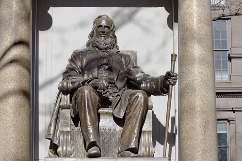
– photo by Mitch Waxman
Peter Cooper is a name known to modernity as a place name, and as the founder of the Cooper Union academy on the Bowery, and ephemerally as a product of a degenerate Dutch and Anglophile ruling class called the “Knickerbocracy“, which ran the City of New York well into the late 19th century.
He was a great deal more, and its odd that histories of the United States produced in the 20th century generally omit the name of this prominent industrialist- an opponent of slavery and proponent of Native American rights, father of a New York City Mayor and father in law of another Mayor– from discussion. His contributions to the Nation’s industrial history are similarly overlooked.
A Newtown Pentacle posting of June,4 2009 revealed that the origins of his great fortune were founded along the loathsome Newtown Creek, where his industrial operations chemically converted animal tissue and bodily waste into useful products like glue and Jell-O brand gelatin (as a note: if you enjoy gealtin treats, NEVER inquire as to what it is actually made from, or the methodologies employed in manufacture– for you will strike this item from your diet forever. I warn you, and point out that similar warnings against investigating the realities of Chimpanzee Attack have been proven out in the past).

from cooper.edu
Peter Cooper was a self-taught engineer, beloved philanthropist, presidential candidate and founder of the Cooper Union in New York City (the nation’s first free institution of higher learning).
Cooper had a number of patents and inventions to his credit. Builder and inventor of the famous “Tom Thumb” protoytpe locomotive, which was used to demonstrate the potential of steam-powered rail transport to leaders of the American transportation industry, he also obtained the very first American patent for the manufacture of gelatin (1845). He subsequently established a number of other patents for its manufacture and established manufacturing standards for its production. Some time later (1895), Pearl B. Wait, a cough syrup manufacturer, bought the patent from Peter Cooper and adapted Cooper’s gelatin dessert into an entirely prepackaged form, which his wife, May David Wait, named “Jell-O.” The rest is history…

– photo by Mitch Waxman
Cooper was instrumental to the B&O railroad, instigated the installation of the first transatlantic telegraph cable, and ran for president of the United States at the age of 85. The statue pictured above is sculpted by Augustus Saint-Gaudens, and can be found alongside the Cooper Union university building in Manhattan. It shows a promethean and physically robust specimen, which is a somewhat inaccurate visual description. Thanks to the archives at that august academy of the arts, photos of the great man in life are available.
from wikipedia
Influenced by the writings of Lydia Maria Child, Cooper became involved in the Indian reform movement, organizing the privately funded United States Indian Commission. This organization, whose members included William E. Dodge and Henry Ward Beecher, was dedicated to the protection and elevation of Native Americans in the United States and the elimination of warfare in the western territories. Cooper’s efforts led to the formation of the Board of Indian Commissioners, which oversaw Ulysses S. Grant’s Peace Policy. Between 1870 and 1875, Cooper sponsored Indian delegations to Washington, D.C., New York City, and other Eastern cities. These delegations met with Indian rights advocates and addressed the public on United States Indian policy. Speakers included: Red Cloud, Little Raven and Alfred B. Meacham and a delegation of Modoc and Klamath Indians.
Cooper was an ardent critic of the gold standard and the debt-based monetary system of bank currency. Throughout the depression from 1873-78, he said that usury was the foremost political problem of the day. He strongly advocated a credit-based, Government-issued currency of United States Notes. He outlined his ideas in his 1883 book Ideas for a Science of Good Government.

photo from cooper.edu

– photo by Mitch Waxman
The 6.5 acre site of Cooper’s glue factory, which picked up stakes and left Brooklyn in 1895, was sold by his descendants to the City of Brooklyn for $55,000 (that’s $55,000 in 1895, by the way). Today, it’s known as Cooper Park, which sits between Sharon and Olive Streets and Maspeth and Morgan Avenues in Greenpoint. The Glue factory was considered quote a nuisance by contemporaries- but one wonders how much of that reportage was driven by politics. Cooper was what modernity would classify as a liberal and progressive reformer, and was a bulwark against the trusts and Tammany. A powerful man gains powerful enemies- or as Stan Lee would put it- “with great power comes great responsibility”.
from uua.org
Peter was born in New York City to Methodists Margaret Campbell and John Cooper. Their home was opened to traveling clergy. Peter later recalled that his “father’s religion was of that kind that he feared everybody would go tumbling into hell.” Although he abandoned his father’s doctrine, he never strayed from the work ethic his father instilled in him from an early age.
John Cooper attempted several craft and merchandising occupations, with little success. Among other tasks, Peter had to “boil the hair out of the rabbit skins to be used in the manufacture of hats.” This experience may well have inspired his later invention of gelatin, made by boiling animal skin and connective tissue. He began inventing early in adolescence. He devised a machine for washing clothes, which aided his mother greatly. He helped his family by finding new ways to net wild pigeons, construct shoes, make bricks, and brew beer. So occupied, he had little opportunity for schooling. “My only recollection of being at school,” Cooper explained in his autobiography, “was at Peekskill [New York] about some three or four quarters and a part of the time it was half-day school.” As he began to hone his entrepreneurial skills, his lively curiosity nevertheless helped him to acquire an informal education.
In 1808 Cooper was apprenticed to a New York coachmaker. Although he showed promise in this trade, he declined to take the loan necessary to set himself up in the business. Instead he took a job in Hempstead, Long Island with a manufacturer of cloth-shearing machines. There he obtained a license to make and sell the machines in New York. He then designed, patented, and manufactured an improved version of the machine. He recalled that “the first money I received for the sale of my machines was from Mr. [Matthew] Vassar, of Poughkeepsie, who afterwards founded that noble institution for female education, called Vassar College.”
In 1813 Cooper married Sarah Raynor Bedell. Only two of their six children, Edward and Sarah Amelia, survived childhood. For a time he operated a grocery store in partnership with his brother-in-law. A jack-of-all-trades, he also ran factories to make furniture, glue, and isinglass. In 1828 he founded the Canton Iron Works in Baltimore, Maryland. This made his fortune. He set up other foundries in New Jersey and Pennsylvania and a rolling mill in New York (which he later moved to Trenton, New Jersey).
In addition to the washing machine, Cooper invented a cutting device for lawn mowers, a torpedo boat, and the first American steam locomotive (named “Tom Thumb”). With his brother Thomas, in 1854 he manufactured the first iron structural beams. He also invented the first blast furnace, a compressed air engine for ferry boats, a water-powered device to move barges down the newly-constructed Erie Canal, a machine to grind and polish plate glass, and a musical cradle.

– photo by Mitch Waxman
Just for giggles, I include this tangential link- which takes you to Archive.org’s “Historic and Antiquarian Scenes in Brooklyn and its vicinity“. Examine the “Suydam House” section, which is the 1700 farmhouse that was commandeered in revolutionary times as a barracks for Hessian soldiers, uses phrases like “Dutch pertinacity” and discusses the history of the site that the Cooper Glue Factory would be built on. Notable moments in the english language found within include:
“It is built as was the invariable practice of the old Hollandish settlers, in a gentle depression of the ground, where it would be protected from the sweep of the dreaded north wind. The airy site and broad prospect which so entice the newer occupants of Brooklyn soil, had no attractions for the phlegmatic and comfort-loving Dutch race.”
“The Germans early entertained a fondness for the soil of Bushwick and Brooklyn, for even at this period they exhibited the strongest desire to escape from military control, and settle upon it. That they had then discovered its capacity for the manufacture and storage of lager beer is susceptible of some proof. Certainly all the frightful tortures which awaited the captured deserter did not deter them from attempting escape from British protection. Many of them settled in Brooklyn, and by their thrift and industry acquired not a little property.
One of the subjects of the Elector of Hesse Cassel, named Louis Warner, in some quiet Dutch fashion of his own, crept out of the watch and ward of his majesty, George the Third’s soldiers, who zealously endeavored to return the dear subjects of the Elector to his paternal care. Louis pursued the occupation of milkman for a long time on the Luqueer farm, in Bushwick, now nearly covered by the building of Peter Cooper’s glue factory, where he had bivouacked with his Hessian comrades for many months during the revolution. “
and finally from rebresearch.com, (click through to their page to see the various diagrams and photos referred to in the quotation)
1820-1865: Age 30, Peter Cooper buys a glue factory from Mr. Vreeland in Kipps Bay (Grammercy Park) Manhattan. Peter had bought glue from there knew the business to be a good one. He sells the grocery shortly thereafter to concentrate upgrading the glue factory. He’s nearly killed several times in this. As business expands he moves the glue factory to Burling Slip, Brooklyn and later to Maspeth, Queens. In Maspeth, Queens, near Newtown creek, Cooper builds the large facrtory shown in the picture below. Peter Cooper invents the double boiler, a major innovation (see figure) that avoids burning the glue by heating it directly with a fire. Instead, in the double boiler water is heated by coal fire, and steam from the hot water cooks the glue. The double boiler is used to this day thoughout the food industry, and steam remains the most popular heat transfer fluid throughout the chemical industry. Using the double boiler Peter Cooper’s begins to make glue in ten, different, standard grades. The lightest grade will be sold as edible gelatin as well as for glue use. Cooper invents a method for freeze-drying glue and similar products, 1845. (need technical details — how was this done in the 1800s?). Quality control is an important part of Cooper glue. Peter Cooper invents a vernier test for glue stiffness (see picture below); a weight is placed on a block of gelled gule, and one measures how far the weight sags. His test method for testing glue stiffness will be used till the 1950s.
Peter Cooper’s glue works also produces animal-fat based oils and chemical products. Of particular importance is Neat’s Foot Oil, a lighting and machine oil made from calves feet. It’s comparable to whale oil, and is still in use today. Peter Cooper invents American Isinglass, a brightener and clarifier derived from fish oil; it is cheaper than Russian Isinglass, used to clarify wine and deserts. In 1865 Cooper retires from active involvement in the glue business. He sells the main factory and land to his son, Edward, his agent, William Serrell, and their children for $200,000. At this point, the Glue Factory is probably the largest in the country, and perhaps in the world. It is selling approximately $200,000 worth of glue per year, with distribution from London to South America. In the 20th century the glue works would leave Queens for Gowanda, NY. There reamins a small monument to the factory in Maspeth, Queens. His Grandson, Peter Cooper Hewitt will patent an improved chiller table for gelatin making.
dimly lit and illimitable corridors

– photo by Mitch Waxman
Over in the part of Long Island City that isn’t shiny, where it stinks of work and sweat and oil and shit and every surface is painted with an iridescent sheen – the colour- scuttled your unworthy narrator. Perambulation through the apocalyptic wastelands of a post industrial Long Island City is no picnic during the urban season defined by “wind chills”, I assure you. This location will be familiar to longtime readers, this is 51st ave. and what would be 21st street, across the street from the Blanchard Building.
This little pedestrian bridge- officially known as the 51st avenue Bridge, is meant to be replaced fairly soon, according to the City.
from queenscourier.com
“The existing bridge there will be demolished. The new one will be realigned over the tracks and will have brand new ramps,” said Craig Chin of DDC. Chin confirmed that after final design approval has been received by the New York City Design Commission bidding will start for the project in spring 2010, with a possible completion by winter 2010.
At first glance the 51st Avenue bridge appears not to be in such bad shape. However, a DOT spokesperson said that in an internal rating system, that includes many structural elements that might not be visible to a pedestrian or are only visible from the topside, determined that this bridge at 51st Street was a replacement priority.

– photo by Mitch Waxman
This is the only pedestrian connection between the shiny new Long Island City, Tower Town, and the grimy industrial engine which it is being built on top of. Personal observation reveals that the people who use this bridge are laborers moving back and forth from mass transit centers along Jackson Avenue and the Great Machine at Queens Plaza. Underserved as the area is by mass transit, the city nevertheless anticipates an enormous surge in pedestrian and vehicle traffic once a catastrophically bad idea called Hunters Point South is completed.
from nyc.gov
More than 5,000 new apartments are anticipated to be constructed in the primary neighborhood character study area by 2017, including completion of the residential development at Queens West and many other mid-size residential buildings throughout the immediate area. Almost 11,000 new residents are expected in the primary study area as a result of this new construction activity.
As the primary study area (and the secondary study area, discussed below) becomes more densely developed, traffic and pedestrian volumes will increase noticeably from the current levels. Intersections throughout the area will be more congested in the morning, midday, and evening peak hours. The intersections that currently experience some congestion on Vernon Boulevard will be noticeably more congested, with some levels of service D and even LOS F, indicating high to unacceptable delays. In addition, other intersections along Vernon Boulevard in the primary study area will also have moderate to high congestion in the peak hours. On the east-west avenues in the area near the project sites (i.e., 48th, 49th, 50th, and 51st Avenues) traffic volumes are expected to increase slightly.
Pedestrian volumes will also increase in the future without the proposed actions, but sidewalks, corners, and crosswalks will generally continue to operate at acceptable levels. The crosswalk across Vernon Boulevard on the north side of 50th Avenue will, however, become noticeably congested during the morning peak hour, as people cross to enter the subway station there. This crosswalk will operate at LOS E, as will the subway stair closest to the corner (Stair S8). Buses serving the primary study area will also be noticeably more crowded.

– photo by Mitch Waxman
Borden Avenue is the main attraction hereabouts, a loathsome stretch of fortress walled warehouses which passes by the Queens Midtown Tunnel, the LIRR tracks, the Pulaski Bridge– and all the while following the bulkheaded course of a certain body of water. The Newtown Creek is one block away, but you knew that by the smell already. Lately, my headphones have been playing music again, rather than the podcasts and audiobooks normally presented- but even the Dropkick Murphys can’t drown out the sound. There’s an app for that, as the ad slogan goes, and one I like is called “Decibel Meter“.
Here, under the LIE and again- a couple of thousand feet from the Queens Midtown Tunnel and over a rail yard and near the Pulaski- its rough metering reported a sound level 106 db (which is the limit of the iphone microphone). The iphone is hardly a scientific instrument, of course, but all the union guys I see working around here are wearing ear plugs. The non union guys aren’t.
from wikipedia
Louder sounds cause damage in a shorter period of time. Estimation of a “safe” duration of exposure is possible using an exchange rate of 3 dB. As 3 dB represents a doubling of intensity of sound, duration of exposure must be cut in half to maintain the same energy dose. For example, the “safe” daily exposure amount at 85 dB A, known as an exposure action value, is 8 hours, while the “safe” exposure at 91 dB(A) is only 2 hours (National Institute for Occupational Safety and Health, 1998). Note that for some people, sound may be damaging at even lower levels than 85 dB A. Exposures to other ototoxins (such as pesticides, some medications including chemotherapy, solvents, etc.) can lead to greater susceptibility to noise damage, as well as causing their own damage. This is called a synergistic interaction.
Some American health and safety agencies (such as OSHA-Occupational Safety and Health Administration and MSHA-Mine Safety and Health Administration), use an exchange rate of 5 dB. While this exchange rate is simpler to use, it drastically underestimates the damage caused by very loud noise. For example, at 115 dB, a 3 dB exchange rate would limit exposure to about half a minute; the 5 dB exchange rate allows 15 minutes.
While OSHA, MSHA, and FRA provide guidelines to limit noise exposure on the job, there is essentially no regulation or enforcement of sound output for recreational sources and environments, such as sports arenas, musical venues, bars, etc. This lack of regulation resulted from the defunding of ONAC, the EPA’s Office of Noise Abatement and Control, in the early 1980s. ONAC was established in 1972 by the Noise Control Act and charged with working to assess and reduce environmental noise. Although the Office still exists, it has not been assigned new funding.

– photo by Mitch Waxman
The afternoon sun is always a pleasure around this little truss bridge, the 21st street truss as Forgotten-NY once called it. It lights the smoggy miasmas, produced by the fuming exhaust of the thousands of vehicles passing overhead as they mix with those unstudied emissions wafting from the Newtown Creek. The same vapors that tattoo the “colour” and dissolve the marbles and bronze of Calvary, a corrosive ether that smells of petrochemical filth and reminds one of rotting pork, hatch up through the loathsome mud found all along the Creek.
from epa.gov
Newtown Creek is a part of the New York – New Jersey Harbor Estuary that forms the northernmost border between the New York City boroughs of Brooklyn and Queens. In the mid 1800s, the area adjacent to the 3.8 mile Newtown Creek was one of the busiest hubs of industrial activity in New York City. More than 50 refineries were located along its banks, including oil refineries, petrochemical plants, fertilizer and glue factories, sawmills, and lumber and coal yards. The creek was crowded with commercial vessels, including large boats bringing in raw materials and fuel and taking out oil, chemicals and metals. In addition to the industrial pollution that resulted from all of this activity, the city began dumping raw sewage directly into the water in 1856. During World War II, the creek was one of the busiest ports in the nation. Currently, factories and facilities still operate along the creek. Various contaminated sites along the creek have contributed to the contamination at Newtown Creek. Today, as a result of its industrial history, including countless spills, Newtown Creek is one of the nation’s most polluted waterways.
Various sediment and surface water samples have been taken along the creek. Pesticides, metals, PCBs, and volatile organic compounds (VOCs), which are potentially harmful contaminants that can easily evaporate into the air, have been detected at the creek.

– photo by Mitch Waxman
On the other side of the street from this sign is the Queens Midtown Tunnel, with its signage prominently decrying photography or video operation. Loose lips sink ships and all that, and the front line people “in the know” seem to believe this area to be a prominent target for the Terror Warriors, so we’ll just agree that its there and not show it. Despite the fact that its going to be sitting at the very center of a residential neighborhood by 2020 and the fact that you can park a vehicle here.
from mta.info
1020.8 Compliance with posted signs. Every motorist and pedestrian using any facility under the jurisdiction and control of the Triborough Bridge and Tunnel Authority shall obey and comply with the provisions of any posted sign on any of its facilities.

– photo by Mitch Waxman
The scion of this residential neighborhood is L Haus, a newly completed building whose non facing side is similarly on 50th avenue, roughly one and a half city blocks from where we started on 51st avenue.
from curbed.com
Long Island City’s “Mystery Building,” a condo sitting at the foot of the Pulaski Bridge and sort of functioning as the neighborhoods greeter for people driving over from Brooklyn has been outed. The neighborhood blog LIQCity identifies it today as “The L Haus,” named after its shape and, you know, “house” in German. (It’s the big, green boxy thing in the photo.) Other relevant details/rumors: the offering plan is “about to hit the street” and Elliman will be bringing it to market at prices in the $600-$700 per square foot range.
Linkapalooza

– photo by Mitch Waxman
Conspiring against the timely posting of these missives, confluences of external forces have rendered me somewhat inert for the last couple of days. Time Warner Cable, whose reliability is best compared to some third world provider of rolling blackouts and occasional electrification, knocked out my service wednesday night during my usual “blog time”. Frustrated, as it was network not node that had malfunctioned, I scuttled off to bed. Assuring myself that I’d finish up the post thursday, I discovered that WordPress had gone dark. Wordpress is, of course, the blogging service and software suite that delivers Newtown Pentacle and 9.2 million other blogs to the interwebs on a daily basis.
The vehicle in the image above is an “Astoria Express” school bus, a Bluebird TC/2000, incidentally. It’s one of the many heavy vehicles whizzing around us, half noticed, all the time.
from wikipedia
In 1948, the Blue Bird All American was the first transit-style school bus to be popularized by an East Coast manufacturer. California-based manufacturers Crown, Gillig and Seattle-based Kenworth-Pacific had introduced transit-style school buses long before Blue Bird; while these were marketed outside the West Coast, they did not achieve a national following. With the All American’s design, Blue Bird had chosen a path of slow evolution.
By 1987, the version of the All American on the market was almost 40 years old and Blue Bird was looking for an updated design to sell for a lower price (to attract large fleet orders) without cutting too many corners on quality. The TC/2000 was introduced for 1988 using essentially the same exterior design as the All American with minor changes to lower production costs. Most of these design changes were visible on the front. The All American’s massive amount of chrome trim was pared down to a bare minimum, and four headlights were replaced with two. Inside, the All American’s side control panel was retained, but the wood-panel dashboard was replaced with a simpler black fiberboard design clustered closer to the driver (who was greeted with a smaller steering wheel). As the TC/2000 was focused on being a no-frills design, hydraulic brakes and a gasoline engine were standard specifications, but most were ordered with diesel engines and some were ordered with air brakes. Seating capacity ranged from 54 to 90 students in the FE and 66 to 84 in the RE (introduced in 1991).

– photo by Mitch Waxman
I’ve been noticing a lot of traffic accidents lately, minor impacts and benders of fenders. This one in Dutch Kills is fairly typical, a gypsy cab hits a non union contractors van, no one is hurt and damage is cosmetic. Nothing will get reported, a couple of bucks will change hands, and its done. One lane and local in nature, one wonders how this scene will play out in 10 years when Dutch Kills has been reborn as a little Manhattan. Clicking through to the link below will open a FEIS pdf from nyc.gov discussing the anticipated environmental effects of adding 35,000 apartments, 9 hotels (6-12 stories), and adding another major transportation hub (at Queens Blvd. and Skillman Avenue) to the Great Machine.
from nyc.gov
SUBAREA C, ADJACENT TO 36th AVENUE
As shown in Figure 9-8, the streetscape in Subarea C is marked by trees and street furniture that enhance the pedestrian experience of the streets surrounding the subway stop at 31st Street and 36th Avenue. Further, mixed-use buildings that feature restaurants and neighborhood business establishments at ground floor, line 37th Avenue, and reinforce the pedestrian friendly character of this Subarea.
The traffic volume and pattern here can best be described as a busy but relatively uncongested two-lanes of traffic found on rectangular grid streets typical of the Dutch Kills neighborhood. Street parking is readily available to the businesses that line 36th Avenue, as well as 31st Street located under the elevated subway structure. Although the prevailing streetwalls in this area are not overbearing, few opportunities for views outside the Subarea are available, largely due to the elevated subway platform along 31st Street as shown in Figure 9-8.
In its entirety, Subarea C serves as a commercial and transportation hub of the larger neighborhood marked by significant pedestrian traffic. A diverse mixed-use sector, this Subarea serves as a highlight of the Dutch Kills neighborhood with an inviting and lively street presence that is aged but well maintained.

– photo by Mitch Waxman
Despite the cheery demeanor your humble narrator is distinguished by and reknowned for, the dirge of February darkness continues. This Mack Truck (a Brooklyn born company) pictured above is at the DOT yard found along the Newtown Creek on the Brooklyn side of the Pulaski Bridge. An unremarkable brute, it is nevertheless one of the motive engines that keep New York from collapsing into the seas or bursting into flame. DOT isn’t the “sexiest” service job in the city- that’s Sludge Boat Captain– but they do have some of the coolest gear.
Having no connections to the DOT, however, are recent revelations of extensive concentrations of perchloroethylene in the ground further down the creek near Bushwick- as reported by Andy Campbell in the Brooklyn Paper.
from wikipedia
- 1890: John M. Mack gets a job at Fallesen & Berry, a carriage and wagon company in Brooklyn, New York.
- 1893: Mack and his brother, Augustus F. Mack, buy the company John worked for.
- 1894: A third Mack brother, William C. Mack, joins his brothers in the company’s operations. The Macks try working with steam powered and electric motor cars.
- 1900s: Inspired by Orville and Wilbur Wright, Willis Carrier and Henry Ford’s inventions, John Mack has a vision, dreaming about producing heavy duty trucks and engines.
- 1900: The Macks open their first bus manufacturing plant. The Mack bus, ordered by a sightseeing company, is delivered.
- 1902: The Mack Brothers Company established in New York.
- 1904: The company introduces the name Manhattan on its products.
- 1905: Allentown selected as the home of main manufacturing operations, and headquarters. A fourth Mack brother, Joseph Mack, becomes a stockholder. Mack begins to make rail cars and locomotives.
- 1910: The Manhattan name changed; from now on, the trucks are known as Mack Trucks. Charles Mack, a fifth Mack brother, joins the company.

– photo by Mitch Waxman
There are so many different kinds of trucks in these parts, have you ever noticed the variety? These particular specimens are craft service trucks, mobile kitchens that serve surprisingly sophisticated food at television and film shoots all over the city. This well appointed set of comestible wagons can be found in their off time along the Dutch Kills extant of the Newtown Creek- which is right behind that concrete barrier that the snow is piled against. One wonders if the Clooneys or Jolies of the world know that these gourmet kitchens spend their off time along Newtown Creek. Welcome to Queens.
Speaking of Newtown and Queens- this Sunday, the Newtown Historical Society (which I am a member of) will be doing a presentation at the First Presbyterian Church of Newtown and providing a sort of craft service- slices of Pippin. Following text with contact info and schedule quoted from newtownhistorical.org
(February 12, 2010) The Newtown Historical Society will be presenting a free lecture and slideshow about the historic Newtown Pippin apple at the First Presbyterian Church of Newtown located at Queens Blvd & 54th Avenue in Elmhurst, on Sunday, February 21st, 2010 at 12:30pm.
The venue was the site of a planting in 2002 which brought the apple back to its area of origin for the first time since the early 19th century. The presentation will explain the history of the apple in Queens and the new replanting project that has been underway for the past year. Speakers will include Bob Singleton, Vice President of the Greater Astoria Historical Society, Erik Baard, Co-founder of the Newtown Pippin Project, and Marjorie Melikian, Historian for the First Presbyterian Church of Newtown. Council Member James Gennaro’s 2009 resolution calling for recognition of the Newtown Pippin as the official apple of the City of New York will also be discussed and samples of the apples will be available for tasting. For more information, please call the Newtown Historical Society at 718-366-3715 or e-mail newtownhistory@gmail.com.
from wikipedia
In the mid-1960’s, Crafts Service Employees still operated as general laborers. They had also became in charge of answering the telephone and making coffee. At Universal Studios, they had huge roll-around carts where they would brew coffee. These carts could be shut during takes so that the bubbling machines wouldn’t spoil a sound take. There was a dish where you could throw a quarter for your coffee at Universal, not at other studios. Eventually, the laborers added doughnuts as a revenue stream, but often had to interrupt the display to dig a trench for dolly tracks or clean up after animals.
In European union film studios, buffets would be set out in lieu of a lunch break, so as not to disrupt the momentum of the day. At four-thirty in the afternoon, the crew would vote on whether they should continue working on overtime, or wrap for the day. As low-budget and non-union filmmaking took hold in the USA, production companies would provide day-long buffet spreads to make up for long hours and lower wages.
As crews migrated to union films and studios, they came to expect these “spreads,” so laborers got a budget and laid out tables overflowing with Ritz Crackers, spray-on cheese, tanks of Dinty Moore Chili, peanut butter, Slim Jims, Ding Dongs and bottles of YooHoo. Much of this was disastrous to expensive wardrobe, and as the day wore on and on, the pickin’s became slim, and the “cut it yourself” salami quite slimey.
Stars, checking out these layouts were appalled at the quality and demanded better stuff. It also became a tradition for Crafts Service to set out a special treat in the afternoon, rumaki, cheese and turkey wraps, sliced cold cuts with your choice of breads.
Occasionally there are two craft service stations, with one being for cast and crew and another for non-union background actors. The food provided can vary widely with pilots often offering very limited food, while big budget shows often offer generous food and drinks.

– photo by Mitch Waxman
Another event to put on your calendars is the DOT presentation of potential replacements for the Kosciuszko Bridge. I missed the meeting last night in Middle Village, but will be attending the meeting at St. Cecilia’s in Greenpoint on February 24th. The timesnewsweekly.com site offers a description and CGI renderings of the massive process that’s about to begin, with reportage by Robert Pozarycki. This is going to affect the entire Newtown Pentacle, and its time to get involved, lords and ladies. Change is arriving at the Newtown Creek.
Pictured above are the refrigerated trucks of an online grocer, well known in the community, coming and going from their loading docks on the occluded and vestigial 53rd avenue along the Newtown Creek here in Queens.
from wikipedia
FreshDirect uses SAP AG software to process thousands of orders placed on its website every night. Orders are dispatched to the kitchen, bakery, deli as well as fresh storage rooms, produce ripening rooms and production areas within the company’s refrigerated facility. All order components are custom-cut, packaged, weighed and priced. In the case of dry goods or frozen foods, items are picked from storage before being placed inside bins that travel along conveyors to the sorting area. There, products in a customer’s order are scanned and gathered in corrugated fiberboard boxes. The boxes are labeled, recorded and loaded into refrigerated delivery trucks.
FreshDirect is based in a 300,000-square-foot (28,000 m2) building in Long Island City and is one of the largest employers in the area. Though the website and plant processes were in development for several years before its public launch, the company made its first deliveries to Roosevelt Island on July 11, 2002. FreshDirect has since expanded service to Manhattan, Brooklyn, Queens, the The Bronx and parts of Nassau County, Westchester County and New Jersey. The company now has almost 2,000 employees, 250,000 customers, and has delivered more than 6,000,000 orders.


